
Brad L. Schultz Jr., Memorial Park Photos


More like Brad L. Schultz Jr., Memorial Park
Recommended Reviews - Brad L. Schultz Jr., Memorial Park
Start your review...

5 years ago
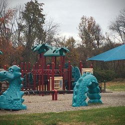
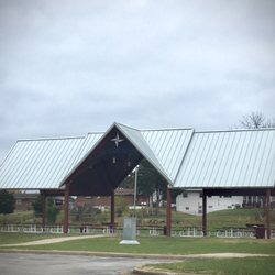
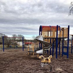
This 1-acre park managed by the village of Riverview has a picnic pavilion, a couple of playgrounds, and green space. It's easy to miss since there's absolutely no signage. Also, Riverview lists the location as Toelle and Chambers roads. Parents needn't worry much about a toddler making their way onto busy Chambers: the park is actually on the cross street and sits considerably back from Chambers. No restrooms here. The park was named for a Riverview fallen police officer. read more
More info about Brad L. Schultz Jr., Memorial Park
Toelle Ln & Chambers Rd
Riverview, MO 63137
Directions
Hours
Outdoor Amenities


Brad L. Schultz Jr., Memorial Park - parks - Updated July 2026
Best of Riverview
People found Brad L. Schultz Jr., Memorial Park by searching for…
Toddler Playground in Riverview, MO
Toddler Parks in Riverview, MO
Places to Take Pictures in Riverview, MO
Walking Trails in Riverview, MO
Running Trails in Riverview, MO
Fishing Spots in Riverview, MO
Parks for Picnics in Riverview, MO
Swimming Lakes in Riverview, MO
Running Tracks Open to the Public in Riverview, MO
Playgrounds for Kids in Riverview, MO
Trending Searches in Riverview, MO
Browse Articles
Browse Nearby
BEST of Riverview, Missouri Coffee near Brad L. Schultz Jr., Memorial Park
BEST of Riverview, Missouri Restaurants near Brad L. Schultz Jr., Memorial Park
BEST of Riverview, Missouri Things to Do near Brad L. Schultz Jr., Memorial Park
BEST of Riverview, Missouri Hiking near Brad L. Schultz Jr., Memorial Park
BEST of Riverview, Missouri Breakfast near Brad L. Schultz Jr., Memorial Park
BEST of Riverview, Missouri Fishing near Brad L. Schultz Jr., Memorial Park
Browse Brands
Related Searches in Riverview, MO
Best Fishing Locations and Guides in Riverview, Missouri
Best Off Leash Dog Parks in Riverview, Missouri
Best Parks for Parties and Events in Riverview, Missouri
Best Water Parks for Kids in Riverview, Missouri
Check Out Great Playgrounds in Riverview, Missouri
Discover Baseball Fields Around Riverview, Missouri
Discover Fun Activities to Do in Riverview, Missouri
Discover Fun Toddler Parks in Riverview, Missouri for Your Little One
Discover Lakes & Ponds to Explore in Riverview, Missouri
Discover Soccer Fields in Riverview, Missouri Near You
Discover Top Nature Parks to Visit in Riverview, Missouri
Enjoy Arts & Entertainment in Riverview, Missouri
Enjoy Hiking Adventures in Riverview, Missouri
Enjoy the Best Picnic Spots and Ideas in Riverview, Missouri
Experience Stunning Sunset Views in Riverview, Missouri
Explore Free Picnic Areas Around Riverview, Missouri
Explore Parks With Pull Up Bars in Riverview, Missouri
Explore Picnic Parks Near Riverview, Missouri
Explore Popular Campgrounds Near Riverview, Missouri
Explore Popular Picnic Areas Around Riverview, Missouri
Explore Popular Recreation Centers Around Riverview, Missouri
Explore Popular Scenic Views Near Riverview, Missouri
Explore Scenic Lakes to Visit in Riverview, Missouri
Explore Summer Camps for All Ages in Riverview, Missouri
Explore Top Dog Parks in Riverview, Missouri Near You
Explore Top Gyms in Riverview, Missouri Now
Explore Venues & Event Spaces in Riverview, Missouri
Find Beautiful Views in Riverview, Missouri
Find Great Places to Feed Ducks in Riverview, Missouri
Find Parks and Recreation Activities in Riverview, Missouri
Find Top Dog Friendly Parks to Visit in Riverview, Missouri
Find Top Skate Parks in Riverview, Missouri for All Skill Levels
Find Top Skating Rinks in Riverview, Missouri for All Ages
Find a Park With BBQ Pits in Riverview, Missouri
Find the Best Parks BBQ Grills in Riverview, Missouri
Find the Best Parks for Picnics in Riverview, Missouri
Fun Indoor Activities to Try in Riverview, Missouri
Have Fun at a Splash Pad in Riverview, Missouri
Picnic Areas With BBQ Pits Available in Riverview, Missouri
Popular Kids Activities in Riverview, Missouri
Popular Picnic Spots to Visit in Riverview, Missouri
Popular Things to Do in Riverview, Missouri
Safe and Fun Parks for Kids in Riverview, Missouri
See Top Fireworks Events in Riverview, Missouri
Top Amusement Parks to Visit in Riverview, Missouri
Top Hiking Trails to Explore in Riverview, Missouri
Top Playgrounds for Kids to Enjoy in Riverview, Missouri
Top-Rated Basketball Courts to Play at in Riverview, Missouri