Cancel

    Open app

    Search

    Daniel Frost Historical Marker

    3.0 (1 review)

    Daniel Frost Historical Marker Photos

    Recommended Reviews - Daniel Frost Historical Marker

    Your trust is our priority, so businesses can't pay to alter or remove their reviews. Learn more about reviews.
    Yelp app icon
    Browse more easily on the app
    Review Feed Illustration
    Photo of Bruce K.
    2415
    25979
    76354

    6 months ago

    Helpful 9
    Thanks 3
    Love this 3
    Oh no 0

    Verify this business for free

    Get access to customer & competitor insights.

    Verify this business

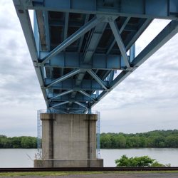
    William S. Ritchie Jr. Bridge - unders

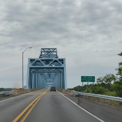
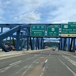
    William S. Ritchie Jr. Bridge

    4.0(2 reviews)
    0.5 mi

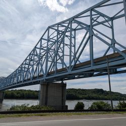
    Officially the William S. Ritchie Jr. Bridge, the Ravenswood bridge connects Ravenswood West…read moreVirginia with Meigs County Ohio. It was completed in 1981, replacing a ferry service that operated here at least to 1908. It carries US Route 33 across the Ohio River. It is a cantilever bridge with a total length of 2710 feet and a main span of 900 feet. There are two lanes. William S. Ritchie Jr. (1928-2006) was a pioneering civil engineer and public servant whose legacy helped shape West Virginia's modern transportation infrastructure. Ritchie served two terms as Commissioner of Highways for the state, first in 1968 and again in 1985, overseeing the planning and construction of hundreds of miles of interstate and local roads--including the completion of Interstate 64 and the iconic New River Gorge Bridge. In retirement, he served three terms as Mayor of Ravenswood. There is no toll to cross the bridge. [Review 583 of 2025 - 167 in West Virginia - 24144 overall]

    came across this bridge going to Columbus on a Saturday afternoon hot dog run out of northern…read morecarolina. access from the east involves circling a mobile home community fronting the river, to the west it's Ohio as far as the eye can see... named in honor of the former state highways commissioner the WSR bridge clocks in at just over 2700 feet long and about 75 feet above the water. completed in 1981 this wonderful specimen of cantilevered through trussedness spans the Ohio River at Ravenswood, West Virginia carrying US Route 33 towards Columbus and parts west.

    Photos
    William S. Ritchie Jr. Bridge - Plaque

    Plaque

    William S. Ritchie Jr. Bridge - William S. Ritchie Jr. Bridge from the West Virginia side

    William S. Ritchie Jr. Bridge from the West Virginia side

    William S. Ritchie Jr. Bridge - William S. Ritchie Jr. Bridge from the West Virginia side

    See all

    William S. Ritchie Jr. Bridge from the West Virginia side

    Sarvis Fork Covered Bridge - Sarvis Fork Covered Bridge, Sandyville

    Sarvis Fork Covered Bridge

    4.5(2 reviews)
    6.3 mi

    With signs along the way clearly pointing out that the bridge has only nine feet of clearance and…read moremy Sprinter van is ten feet tall with the solar panels on the roof, I was hoping that there would be a spot nearby that I could stop and u-turn. There was and I was able to walk the bridge that is open to vehicular traffic. The Sarvis Fork Covered Bridge, also known as the Sandyville Covered Bridge, is a beautifully preserved Long Truss structure that was completed in 1890. It first spanned John Carnahan's Fork, a branch of Mill Creek. When a newer modern bridge was completed, the covered bridge was relocated here in 1924 and rebuilt in 2000 with the original timber decking and siding. This is one of two remaining covered bridges in Jackson County (the other is the Staats Mill Covered Bridge). It measures 101 feet 3.5 inches long and 11 feet 8 inches wide with 13 Long Truss panels, reinforced with steel stringers and a dual-bent support system, allowing it to carry modern traffic. [Review 581 of 2025 - 165 in West Virginia - 24142 overall]

    Sarvis Fork Covered Bridge Sandyville, WV - Jackson Co., WV…read more Sarvis Fork Covered Bridge built in 1890, originally spanned over John Carnahan's Branch of Mill Creek. 101 feet Bridge was moved and rebuilt in 2000 and is opened to public traffic still today. The Bridge is located not to far off the main highway leading to Parkersburg from Ripley. Easy to locate.

    Photos
    Sarvis Fork Covered Bridge - Sarvis Fork Covered Bridge, Sandyville

    Sarvis Fork Covered Bridge, Sandyville

    Sarvis Fork Covered Bridge - Sarvis Fork Covered Bridge, Sandyville

    Sarvis Fork Covered Bridge, Sandyville

    Sarvis Fork Covered Bridge - Sarvis Fork Covered Bridge, Sandyville

    See all

    Sarvis Fork Covered Bridge, Sandyville

    South Side Bridge - South Side Bridge, Charleston

    South Side Bridge

    5.0(2 reviews)
    41.7 mi

    As a city on a river, Charleston has a handful of bridges that ensure the two sides are able to…read moreconnect. While the upriver Chuck Yeager Bridge carries both I-77 and I-64 over the river, this one is downriver from the city and is simply named the South Side Bridge. Perhaps one day it will get named after a worthy West Virginian. In the meanwhile, the South Side Bridge was built in 1936 by the Wisconsin Bridge and Iron Company and was updated in 1990. The bridge spans 1146 feet with a main span of 420 feet and is 38.7 feet wide. It is a Parker through truss bridge. It brings I-64 over not only the Kanawha River but also Kanawha Boulevard and MacCorkle Avenue and a railroad line. My two crossings of the bridge today were easy and smooth thanks to low weekend traffic. As there are signs on the bridge that note the "exit only" lanes, it is likely much more challenging during rush hour. There is no toll here which is a positive. [Review 566 of 2025 - 151 in West Virginia - 24127 overall]

    The 1148-foot South Side Bridge opened in 1936 and carries Dickinson Street over the Kanahwa River…read morein the middle of Charleston WV. It is a through truss bridge with clearance enough for a Lockheed F-80 Shooting Star doing 500mph to miss the water and the deck. According to an April 2010 item in the Charleston Gazette this is the bridge Chuck Yeager famously flew under in 1948 - a year after breaking the sound barrier: one pass, heading west, to impress/scare the locals and then back to work. No more, no less, the general was just having a little too much fun. Yea Chuck!

    Photos
    South Side Bridge - South Side Bridge, Charleston

    South Side Bridge, Charleston

    South Side Bridge - South Side Bridge, Charleston

    South Side Bridge, Charleston

    South Side Bridge - South Side Bridge, Charleston

    See all

    South Side Bridge, Charleston

    Criel Mound - Indian Mound Historical Marker at Criel Mound, South Charleston

    Criel Mound

    5.0(5 reviews)
    39.8 mi

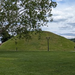
    If you're cruising through South Charleston and spot a big grassy hill tucked between antique shops…read moreand quiet streets, that's the Criel Mound. It's worth a stop. It's not flashy, but there's something grounding about standing next to a structure built over 2,000 years ago by the aboriginal people. The steps leading up are wide and gentle, and once you reach the top, you get a surprisingly peaceful view of the neighborhood. It's a quick visit. The mound itself is steeped in mystery and history. Archaeologists found 13 skeletons inside, including a central figure surrounded by others. There's a small park around the mound with interpretive signs that give you just enough context to spark curiosity. Some locals say horse races were once held around it, and there's even talk of burials that might represent alliances between different tribes. It's wild to think about how much has happened on that patch of earth, and how little we still know. The Criel Mound stands to quietly anchor the town. Kids run up the steps, people are walking dogs, and there's me, pausing to read the plaques. There is a sense of reverence here if you feel it. It's not at all a playground. [Review 569 of 2025 - 154 in West Virginia - 24130 overall]

    The Criel Mound is a historic and cultural gem nestled in South Charleston, WV…read more The small park which houses it has plenty of street parking available and several interpretive signs around the mound explaining its history, importance, and what archaeologists discovered inside the mound when excavating. The mound is the second largest Adena mound in West Virginia and is believed to have been developed between 250 and 150 B.C. The Criel Mound was originally one of 50 mounds and prehistoric earthworks located in WV but unfortunately most have since been destroyed due to industrialization. It's definitely worth a visit (plan on about 30 minutes) if you're in the area.

    Photos
    Criel Mound
    Criel Mound
    Criel Mound - Criel Mound, South Charleston

    See all

    Criel Mound, South Charleston

    Blennerhassett Island Historical State Park

    Blennerhassett Island Historical State Park

    4.4(29 reviews)
    24.6 mi

    What a great experience!…read more Ferry tickets have to be purchased at the Museum, which is a short walk from where you board the ferry. You can also purchase a package for the ferry, mansion tour, wagon ride, and museum ($39 as of May 2024). The mansion tour is really excellent. The docents are very knowledgeable. The wagon ride is a must - fun and informative. This is a great day trip!

    Located on a small island in the Ohio River, Blennerhassett Island Historical State Park features a…read morerecreated Palladian mansion to explore, horse drawn buggy tour, and back on the mainland an extensive museum to visit. We started our visit at the museum on the mainland which features many artifacts chronicling the history of the local area as well as several belongings of the original owners of the mansion (the Blennerhassetts) who fled to the US from Ireland after the Uncle and Niece duo decided to get married to much scandal. There is a free parking lot available to park in for visitors. The museum covers three floors and We started in the basement of the museum and made our way up. In the basement you'll find an extensive collection of Native American artefacts, as well as a short film about the island and their entangelment with Aaron Burr. The Blennerhassetts and their island home owe their notoriety to when they allowed their estate to become headquarters for Aaron Burr's military expedition to the Southwest back in 1805 which resulted in them all being arrested and tried for treason and sedition. One of the most interesting finds in the museum includes replicas of Aaron Burr's death mask as well as the pistols used by Burr and Hamilton in their infamous duel. After spending over an hour in the museum, we made the short 2 minute drive from the museum to the pier to wait for the riverboat to ferry us to the island. It was a bit of a drizzly overcast day and their was no signage out anywhere indicating where the ferry would be. Your ticket that you purchase to board the ferry will include the pick up times at the dock and on the island. The island itself and the structure on it are a trove of historical gems and natural beauty. Our guide for the house, Scott, was a wealth of knowledge and was very thorough in his stories about the people who made the island famous and the ultimate downfall of the entire Blennerhassett family. This was a highlight of our trip to West Virginia!

    Photos
    Blennerhassett Island Historical State Park
    Blennerhassett Island Historical State Park
    Blennerhassett Island Historical State Park

    See all

    Staats Mill Covered Bridge - Staats Mill Covered Bridge Historical Marker

    Staats Mill Covered Bridge

    5.0(3 reviews)
    10.1 mi

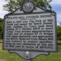
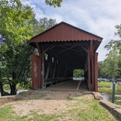
    This beautiful red bridge was completed in 1887 and it originally spanned the Tug Fork of Big Mill…read moreCreek. It was named after Enoch Staats, whose water-powered mill and store anchored the surrounding community. The Staats family were early settlers, arriving around 1780. Enoch's father, Isaac Staats, built the first mill on the site. H.T. Hartley built it using the Long Truss system, patented by Stephen Long in 1830, featuring distinctive "X"-braced diagonals across 11 panels. In 1971, the bridge was modified with steel girders inside the original trusses to support modern loads and in 1983, it was relocated about three miles to here and converted to pedestrian only use. The park can get quite busy on beautiful summer days so be prepared to be challenged finding a parking space. [Review 571 of 2025 - 156 in West Virginia - 24132 overall]

    This lovely piece of history has been a constant in my life growing up. We have many outings at…read moreCedar Lakes Park in Ripley, and this lovely red wooden historical covered bridge has been in the scenery backdrop all those many years. The bridge is well built since 1887. Built in 1887, the Staats Mill Covered Bridge originally crossed the Tug Fork of Big Mill Creek and was named for Enoch Staats' water-powered mill.. The Staats family were early settlers to the area, arriving around 1780. The bridge is a 97-foot-long "long truss" built by Henry Hartley This location is not the original location it was moved here for safe keeping and easy public access. My people use this lovely old bridge as a back drop in photo ops for weddings, prom, graduation, birthday pics, various different ideas. This is a lovely bridge and FREE to enjoy

    Photos
    Staats Mill Covered Bridge - Staats Mill Covered Bridge, Ripley

    Staats Mill Covered Bridge, Ripley

    Staats Mill Covered Bridge - Staats Mill Covered Bridge, Ripley

    Staats Mill Covered Bridge, Ripley

    Staats Mill Covered Bridge - Staats Mill Covered Bridge, Ripley

    See all

    Staats Mill Covered Bridge, Ripley

    Daniel Frost Historical Marker - landmarks - Updated July 2026
    Loading...
    Loading...
    Loading...