Cancel

    Open app

    Search

    David S Ammerman Trail

    4.0 (1 review)

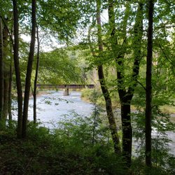
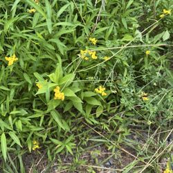
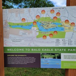
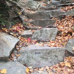
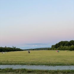
    David S Ammerman Trail Photos

    Recommended Reviews - David S Ammerman Trail

    Your trust is our priority, so businesses can't pay to alter or remove their reviews. Learn more about reviews.
    Yelp app icon
    Browse more easily on the app
    Review Feed Illustration
    Photo of Susan D.
    202
    828
    14

    14 years ago

    Helpful 4
    Thanks 1
    Love this 3
    Oh no 0

    Verify this business for free

    Get access to customer & competitor insights.

    Verify this business

    Lower Trail - Lower Trail

    Lower Trail

    5.0(2 reviews)
    36.2 mi

    By far the best! The service, atmosphere, the food! You get that small town hospitality that it's…read moreknown for. It's the only ice cream place in Williamsburg and they get a good many people from different areas (furthest I met lived in Ebensburg!) just for their tasty food! The owners are so down to earth and take their time with each and every customer. They don't rush you or look overwhelmed. They employ a good many high schoolers, personally I never had a problem with any of them they are just like the owners. A few years ago they put a car port with tables up which is nice! There's also another seating facing the river, a pravillion, and many other shady seating. The trail is right beside them it's my favorite part of Williamsburg. The river sound and shade can make you lose track of time peaceful and certain areas have beaches to picnic or swim. A hot summer day here will make the life stresses leave. With lower trail you'll never stop going it's worth it all.

    This is a well maintained trail winding through the woods along the Frankstown Branch of the…read moreJuniata River and made over an old railroad bed so it's nice and flat for the most part. It goes from Alexandria, PA to Williamsburg, PA and a bit beyond. It's great for biking, horseback riding or just walking. You can park at the Alfarata Station in Alexandria or at the Water Street Flea Market, or at the Flowing Spring Station if you're coming from the other direction. There are four other stations along the way.

    Photos
    Lower Trail - The Old Canal

    The Old Canal

    Lower Trail - Lower Trail

    Lower Trail

    Lower Trail - Lower Trail Alfarata Entrance

    See all

    Lower Trail Alfarata Entrance

    Sandy Creek Trail - Gorgeous rails to trails paved bike route. 24 mile round trip through some amazing scenery!!

    Sandy Creek Trail

    5.0(4 reviews)
    76.8 mi

    One of the prettiest bike rides I've ever taken! This amazing rails to trail fully paved bike path…read moreis 24 miles round trip through some truly spectacular scenery and woodlands. The largest of 7 wooden bridges along the path spans the Allegheny River and the smaller ones cross several creeks. What you don't see are any roads along this gorgeous wilderness path. There is a slight upward grade during much of the 12 miles from Fishermans Cove to the end of the line - the good news is it's nearly imperceptible until you turn around and head back. You feel like you're flying on your return trip which is really fun! This area is the definition of remote so go prepared with food, water & flat tire supplies. There's decent cell service, so bring your phone. There is also a fairly long tunnel mid-trail with reflectors down the center. A light would likely make you feel a tad more comfortable on a cloudy day. The reflectors work decently to direct you on a sunny day. This bike trail is located slightly over an hour north of Cranberry Township. Google map Seneca Hills Bible Camp which is where you turn off Old Route 8 off I-80. At the T heading to the Bible Camp you head right to Fisherman's Cove to the trailhead. If you're interested in more information and specific directions, here is a link: www.avta-trails.org ' sandy-creek-trail

    Wow. This is a spectacular trail!! Such a pleasant ride through the woods crossing the river and…read morecreek multiple times on a paved surface. I don't even know how they managed to get blacktop back into some of these remote areas but they did!! It's mostly shaded as well so even on hot days this would be a great choice when you just want to ride! We started at the western end of the trail called Fisherman's cove. A little tricky to find and accessible by a gravel road about 3 miles off old route 8. Parking here is limited and is roadside so I can imagine it getting pretty crowded on weekends. But it is so worth it. The eastern end is 12 miles out at Van. The ride back seemed a lot quicker since there appears to be a minor downhill heading back although it is an easy ride in both directions. The fact that it's quite remote means there are no road crossings so you can just ride completely carefree!! If you feel up to it you can extend the ride by joining up with other rails to trails and make a long day out of it!! We absolutely loved it and will no doubt be heading back there this fall to enjoy the ride and the scenery! Highly recommended!!

    Photos
    Sandy Creek Trail - The turn around point where the paved trail ends - or you could start here

    See all

    The turn around point where the paved trail ends - or you could start here

    Coal and Coke Trail

    Coal and Coke Trail

    4.5(2 reviews)
    82.7 mi

    The Coal & Coke Trail is a neat little biking and hiking trail in Westmoreland County connecting…read moreMount Pleasant with Scottdale. A mere 5 miles in length, it's one of the few Rails-to-Trails I hadn't covered yet. Really, I couldn't justify the time or gas money to do a 10 mile round trip bike ride. A 10 mile hike is of course another story! And that's just what I did as part of my employer's wellness program. I planned the whole thing and of course headed up the hardy group of hikers able to complete the entire 10 mile round trip. The trail begins and ends in city parks at both ends. We began at Willows Park in Mount Pleasant. The address I gave you above is the parking lot and it's based on information from www.traillink.com Drinking water and restrooms are available in the park, but the restrooms appear to be closed in winter. We began by working our way southbound. The trail was built on the roadbed of a Pennsylvania RR branch. As ts name implies, the railroad hauled coke ad coal over the line. The railroad was abandoned for many years, however after 8 years of planning, the trail opened in 2007. Upon leaving town, we hiked through some scenic wooded areas to the town of Bridgeport. At one point we noticed the trail paralleling an active rail line. The forest here is old growth and we crossed one of a few small streams. Beyond the town of Bridgeport, we again entered the woodlands while paralleling Jacobs Creek. Curving to the west as we approached Scottdale, we arrived at the scenic high point of the day. The sewage treatment plant. Yep! The trail even goes through plant's parking lot and is routed onto Sewage Treatment Lane! Well no worries--we crossed Old US 119 and then ducked under the new highway before entering our last stretch of woodlands. Part of the trail is incomplete at Scottdale, so we had to walk down Mildred Street , Bessemer Street, and Mt. Pleasant Road (they're actually all the same street) before reaching Kendi Park. The trail resumes briefly here but this was our rest stop and turnaround point. So this is a pleasant and relatively easy trail to hike or bike. Just remember, there aren't any places to obtain food or water along the path, so be sure to bring adequate supplies of each.

    Great place to walk. You can choose to challenge yourself or take it easy. Got lots of great pics…read moreas well

    Photos
    Coal and Coke Trail - Quaint short trail.. Very nice

    See all

    Quaint short trail.. Very nice

    6 to 10 Trail

    6 to 10 Trail

    4.5(2 reviews)
    38.4 mi

    The Allegheny Portage Railroad National Historic Site is not only a collection of industrial…read moreartifacts, it's also got a great hiking trail, the 6 to 10 Trail System. The 6 to 10 Trail System is the only way you can see many of the attractions here. But for serious hikers, it's also a great trail for just plain ol' hiking. In fact, the NPS website encourages use of the trail, stating that not only is it good for your health, but also for the health of the national parks. The 6 to 10 Trail System is so named because it connects Engine House #6 and the site of Engine House #10. It's not a circular trail, so it's same-way-out/same-way-back walk. Mountain biking is allowed on east end of the trail only, from Muleshoe Bridge to Engine House #10. But before hiking, I warn you--there are some steep slopes along the way and you should have some experienced hikers in your group. In our foursome, the experienced hikers were the females (Susan and Cindy). Rick and Bob, not so much--but in all fairness to my guy, he's quite the cyclist. Comfortable clothing and sturdy hiking shoes are a must. The 6 to 10 Trail Systems follows the route of the old railroad, but it's not really a rails-to-trails. Not all sections are on the roadbed of the old railway. The construction of a portion of "New" US #22 saw to that! We began our hike upon leaving the Lemon House. We proceeded eastward, coming up on the site of Incline #6, a portion of which has been reconstructed. From Incline #6, we go down the slope and pass under the westbound lanes of "Old" US 22. The next site we encountered was the Skew Arch Bridge. With the construction of the highway, it is actually located between the eastbound and westbound lanes. The bridge can be reached via the trail or the mowed incline. After the bridge, the trail briefly curves to the west before heading east again. There aren't many sites to see on this portion of the trail, but it is a beautiful hike in through here. The trail hugs the park boundary along here before curving to the north again. Ah, here begins the fun part of the trail. The slopes get really steep in through here and they'll test your hiking abilities. But hey, Cindy and I are veterans and if we can tackle the Firelane Trail and the Lower Riverview Trails in Frick Park, we can handle this. "C'mon boys, ya gotta keep up with us! We've barely begun the hike!" I shouldn't talk--I know I'm gonna have to test my sugars soon. We then pass an historic culvert and then come upon the ruins of Engine House #6 and Incline #6. The next site we saw was Muleshoe Bridge. This is a stone arch bridge over "Old" US 22 and is presently closed to hikers and cyclists. This was also built on the Alegheny Portage Railroad right of way, but is much newer. The Pennsylvania Railroad built a freight train bypass line here in 1904 and it remained in use until 1981. The Pennsylvania called it the New Portage Line and a portion of "New" US 22 was built on that too. There is a tunnel up in Gallitzin called New Portage Tunnel and it remains in use by freight and Amtrak trains today. New Portage Tunnel is the sole remaining railroad operating part of the New Portage Line. But back to the Muleshoe Bridge, here is where the bike trail begins. We then passed some more historic culverts and a shout out to my Yelp friend Mike O--no these aren't the "Culverts" where you can get yummy frozen custard. We also passed the Hollidaysburg Reservoir. The State Gamelands are located along here. During hunting season, it is recommended that you wear bright clothing, even though hunting is not allowed on the trail itself. Further east of here, the bike trail splits from the hiking trail. If you're on foot, you will want to remain on the hiking trail. The trail passes the site of Incline #9, although nothing remains. It's mostly a pleasant hike from here and about a mile from the trailhead, the hiking and biking trails rejoin. The Foot of Ten Trail veers off to the left just east of Historic Culvert #1692 and goes to the Engine House #10 ruins at Foot of Ten. The ruins was the end of the line for us too and we decided to take a snack and water break before heading back. Remember, there are no restroom facilities anywhere on the trail. There are no places anywhere on the trail or in the park to obtain food and beverage. Make sure you have an adequate supply before setting out. There are no trashcans along the trail. This is because the park doesn't want furry little creatures scavenging through them. So whatever you bring in, make sure you take out. Finally this is an out-n-back trail. So hike to your abilites. Remember, if you make it to the end, you're really only 1/2 way done because you have to hike back. Thanks to my husband Rick for help in writing this.

    I am training to hike the grand canyon to the bottom and back in one day next month, so this trail…read moreis good prep for that because by starting at the lemon house, you go down first then up. Parts of the 6 to 10 are much steeper than what I will encounter in Arizona. I only did the hiking portion of the trail, as the rest is just flat. Well marked, with a couple exceptions, as I actually veered off the trail unknowingly once. This trail will test your hiking abilities, and will disappoint few serious hikers.

    Photos
    6 to 10 Trail
    6 to 10 Trail
    6 to 10 Trail

    See all

    Mahoning Shadow Trail

    Mahoning Shadow Trail

    4.0(1 review)
    33.7 mi

    4.5 stars. The…read moreMahoning Sghadow Trail is a 15 mile rails-to-trails conversion that connects Valier, PA with the tiny hamlet of Winslow via the famous Punxsutawney, PA. It follows the right-of-way of the Pennsylvania and Northwestern Railroad Line, which served the coal industry in southern Jefferson County. The tracks west of Punxsutawney served the Eureka mines of the Berwind-White Coal Company. Along the way the hiker or cyclist will find a lot of hidden remains of the once flourishing coal and coke industries in the area, including several remnants of coke furnaces. A few of them have been restored with signs saying how and when they were used. My husband Rick and I did a full 30 mile round trip on the trail. We began our ride at the western trailhead in Valier, PA. The trailhead is located on County Road 3015, Fordham Road, about 3/10s of a mile in from County Road 3013. Most on line maps will recognize the address I gave you above. Google Maps is best because it shows bike trails. It's best to start at this end of the trail because there is ample parking available. This section of trail follows the beautiful Mahoning Creek. After following the creek for a little bit, we encountered a second trailhead with limited parking along County Highway 3008. We headed NNE then turned south, passing Saints Peter and Paul Cemetery. We curved away from the creek for a bit, going through a wooded area intermixed with some small fields and homes before re-joining it at Gresock Road. Coming in to Punxsutawney, we passed the Punxsutawney Water Treatment Plant and while that might not have been the historical or scenic highpoint, the remnants of 50 beehive coke ovens are located just west of here. We then crossed the creek on an old railroad bridge that has been re-decked for cyclists. Punxsutawney is the only major town on the trail, and as there are no restrooms or even water pumps or fountains along the way, it's an appropriate rest stop. There is a bit of a detour on city streets, however it's well marked. Leaving Punxsutawney we went through some beautiful woodlands along the creek. The eastern section runs along the tranquil Mahoning to the village of Cloe and from there strays from the waterway a bit. We noticed that the trail is interrupted in Cloe for about 1/4 mile or so. We had to use PA 236 tp pick up the trail again, however we noticed it is well marked. And while we thought the western half of the trail is pretty scenic, we really liked the eastern half. This half of the trail has some steep grades, especially for a former railway line. We climbed through the scenic highlands until we reached the small village of Hudson. There are some deep hemlock forests in through here too. We rode all the way to the eastern trailhead which is at County Raod 2001. The trail pretty much ends here with no parking available. Although it appears to cross the highway, it's a private driveway on the other side. So we did a good 30 mile round trip and although the Mahoning Shadow Trail isn't the longest of our rails-to-trails, it's very scenic and it makes for a good morning's or afternoon's cycling. In addition to my usual bike trips, just remember there are no facilities along the trail except in Punxsutawney.

    Ghost Town Trail

    Ghost Town Trail

    4.7(3 reviews)
    54.0 mi

    This is a gorgeous trail. It is very easy and you can walk as far as you want. The trail is well…read moremaintained (mostly crushed gravel) and a fun place to go for a walk, run, or bike ride. You will see beautiful forest areas along the way.

    Well another biking milestone for yours truly and her husband Rick. We did the entire 60+ mile…read moreround trip between Black Lick and Ebensburg on the Ghost Town Trail! It took all day, I'm still saddle sore and my leg muscles ache a little, but it was totally worth it. Besides, we're building up our strengths so we can do the 120+ miles of the Great Allegheny Passage Trail between McKeesport and Cumberland, MD. There's not too much more I can write about the trail. Last year we rode the Black Lick to Nanty Glo segment of the trail and most points of interest are between those two towns. Still, the remaining segment between Nanty Glo and Ebensburg makes for a pleasant ride. I did find out a few other things about the trail since the last time we rode it. Just east of Black Lick, the trail passes a salvage yard of discarded rail cars. These almost seamlessly blend into the scenery and they're altogether appropriate because this is a rails-to-trails conversion. Between Dilltown and Vintondale the creek has a bright red color because of the acid drainage from the coal mines. At several points you will exit the cool green forested surroundings and experience an "ecological disaster area", a legacy of the mining era. You'll see the remains of some slag dumps, which have an eerie beauty to them. Keep an eye out for the AMD & Art Park (AMD stands for Acid Mine Damage). One other thing to consider. This trail goes through some state game lands. During hunting season, you should wear brightly colored clothing. Riding the Ghost Town Trail can be very rewarding. Plan to take the whole day and be sure to enjoy the sights along the way.

    Photos
    Ghost Town Trail
    Ghost Town Trail - The trail is maintained enough to bring a tricycle

    The trail is maintained enough to bring a tricycle

    Ghost Town Trail

    See all

    David S Ammerman Trail - hiking - Updated June 2026

    Loading...
    Loading...
    Loading...