Flat Creek Falls Photos


More like Flat Creek Falls
Recommended Reviews - Flat Creek Falls
Start your review...



4 years ago
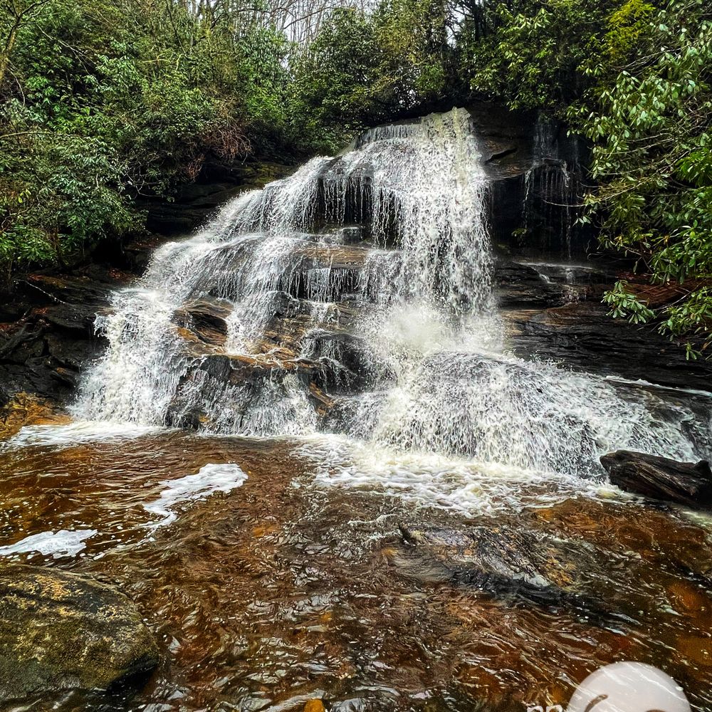
THE FIRST THING YOU NEED TO KNOW is this is one of the most uniquely beautiful waterfalls I've ever had the pleasure of visiting in the South, but it is not for the casual hiker. You absolutely need a basic understanding of how to follow blazes and navigate faint areas of the trail that might be overgrown. You also need to be in fairly good physical shape, because this trail is a WORKOUT... but the payoff is so worth it!!! ***** We completed our hike on Saturday 11/12/2022. While most other website reviews say they didn't encounter any other hikers, we actually came across several. At the falls we met a famous hiker and his crew repelling down the vertical drop section of Flat Creek Falls. I was kinda fanboying in the moment because I've used a number of his hiking notes over the years to guide me to many of the more difficult and less populated trails. On our return hike we also encounter THREE other couples separately headed to the falls. Must have been something in the air that day!!! It rained most of the week prior to our hike, so the falls were flowing nicely. But unfortunately the rain knocked all the remaining fall leaves off the trees, so my photos weren't as fall-tacular as I was hoping. The trail itself is rather boring with no scenic views other than the steep downhill section within the last mile where you can get a glimpse of Bear Lake. It can be a rather tricky trail to follow, but there are enough blazes to keep you on track. This is the first trail of hundreds that I've hiked where strips of a terrycloth towel were used as blaze markers... LOL! But hey, they were REALLY helpful! [ NOTES ] * Flat Creek Falls is broken into sections. The main visible fall is a sheer freefall of about 100 feet. Next it cascades heavily down the mountain, lengthening its overall look. Above the waterfall and out of view is another 30+ feet of sliding cascades, adding to its overall height. A drone would allow the best pic of the full glory of this waterfall. Check out this drone video by Seth Hogan: https://www.youtube.com/watch?v=nT9TiFQtNgE * Lots of blown down trees to climb over/around. * THIS IS A WET HIKE!!! There is almost no way of avoiding getting your shoes or boots wet, so bring extra socks and shoes for the ride home. * Trail can get a little tricky in parts for inexperienced hikers even with the blazes, so be sure to download the offline map. * ALLTRAILS map ends at the lowest decent viewing point. You will still need to boulder jump several more yards to get the best vantage point. * VERY surprised by the "WARNING: BEAR SANCTUARY" markers along the steep downhill section of the trail. * Don't miss NELLIE FALLS which can be accessed along a spur trail near the parking area. DO NOT FOLLOW the wide Flat Creek Road trail. It does not lead to Nellie Falls. Instead, find an unmarked opening in the trees about 100 feet from the parking area AFTER crossing the creek . It looks rather sketchy but follow this trail. It will split in about 1/3rd of a mile and you will continue on the left trail that goes downhill. Once you reach Nellie Falls, you must cross through the river and continue the trail up the left side of a very large boulder to get the best view of Nellie. The hike to Nellie will add about 2 miles to your overall Flat Creek Falls hiking distance. [ NAVIGATION NOTES ] DO NOT... I REPEAT... DO NOT USE GPS NAVIGATION through Panthertown along Forrest Service Road 4670. You WILL NOT get through! Instead, use Hwy 281 to Rock Bridge Rd. The parking area will be at the end of Rock Bridge Road. Also, it is important to download this trail map prior to arriving. Mobile coverage is very weak past Lake Toxaway: https://www.alltrails.com/trail/us/north-carolina/flat-creek-road-flat-creek-falls/print?grid_format=decimal&map_center_lat=35.2159563039431&map_center_lon=-83.03239512200847&map_type=alltrailsOutdoorsV2&map_zoom=14.007959882271786&paper_orientation=portrait&paper_size=letter [ FINAL THOUGHTS ] Maybe it is because I haven't hiked much this year and I'm no longer in hiking shape, but this trail really burned out my legs. I don't remember being this exhausted after a hike since I did Mounte LeConte in Gatlinburg via Alum Cave Trail. ALLTRAILS lists the hiking distance @ 5.8 miles round trip, but I don't believe that is accurate. My iPhone walking tracker logged me at 11.1 miles for the day (which also included the 2 miles round trip to Nellie Falls). Other than walking to my truck in my driveway, inside a restaurant after the hike, and to my shower when I got home... I did no other walking that day. TOTAL HIKE TIME - 5 hours 15 minutes It was a blessing to witness these two spectacular natural piece of art with my own eyes. They've been on my list for the past year and did not disappoint! Thank you Jess L for always being willing to tackle ANY trail with me! 2022 / 116 read more


More info about Flat Creek Falls
Flat Creek Parking Area
Tuckasegee, NC 28783
Directions
Hours
Outdoor Amenities













Flat Creek Falls - hiking - Updated August 2026
Best of Tuckasegee
People found Flat Creek Falls by searching for…
Hiking Trails With Waterfalls in Tuckasegee, NC
Public Shower in Tuckasegee, NC
Scenic Overlook in Tuckasegee, NC
Scenic Views in Tuckasegee, NC
Lookout Points in Tuckasegee, NC
Off Road Trails in Tuckasegee, NC
Secret Spots in Tuckasegee, NC
Things to Do in Tuckasegee, NC
Scenic Drive in Tuckasegee, NC
Beautiful Views in Tuckasegee, NC
Waterfalls and Swimming Holes in Tuckasegee, NC
Historical Tours in Tuckasegee, NC
Historical Sites in Tuckasegee, NC
Lakes & Ponds in Tuckasegee, NC


