Herns Mill Historic Covered Bridge Photos


More like Herns Mill Historic Covered Bridge
Recommended Reviews - Herns Mill Historic Covered Bridge
Start your review...

2 months ago
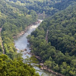
The beautiful farms leading to hear was breath taking. we enjoyed seeing the covered bridge and hearing the water near by. read more


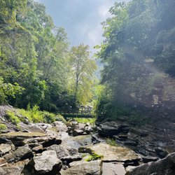
Fan of covered bridges and we were in the area so made a detour to check it out. You could even drive over the bridge. The road to get to the bridge was very narrow ..not 2 car but we came across a truck and we both made it through. The stream rurunning under the bridge was lovely. Fall great time to check it out. read more


3 months ago
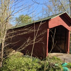
Built after the Civil War in 1884, this is a Queen post trust bridge that is ten feet, 6 inches wide and is 53 feet long. It was built to provide access to the S.S. Hern Mill when it was in operation. The bridge was renovated in 2000 with some stability upgrades and steel beams to ensure the bridge will be here for years. Interesting tidbit - when a local farmer discovered the bridge updates in 2000 no longer allowed him to move a piece of his farm machinery across the bridge, he made some "modifications" with his chainsaw until he achieved the desired width. Don't do that. The bridge was listed on the National Register of Historic Places in 1981. [Review 19605 overall - 79 in West Virginia - 576 of 2023.] read more


More info about Herns Mill Historic Covered Bridge


Herns Mill Historic Covered Bridge - landmarks - Updated June 2026
Best of Lewisburg
People found Herns Mill Historic Covered Bridge by searching for…
Things to Do in Lewisburg, West Virginia
Scenic Views in Lewisburg, West Virginia
Public Services & Government in Lewisburg, West Virginia
Attractions in Lewisburg, West Virginia
Photo Spots in Lewisburg, West Virginia
Tourist Attractions in Lewisburg, West Virginia
Places to Take Pictures in Lewisburg, West Virginia
Sunrise View in Lewisburg, West Virginia
Waterfalls in Lewisburg, West Virginia
Scenic Overlook in Lewisburg, West Virginia
View Points in Lewisburg, West Virginia
Historical Sites in Lewisburg, West Virginia
Reviews in Lewisburg, West Virginia
Bridge in Lewisburg, West Virginia
Night View in Lewisburg, West Virginia
Places to Visit in Lewisburg, West Virginia
Military Museum in Lewisburg, West Virginia
To Do in Lewisburg, West Virginia
Things to See in Lewisburg, West Virginia
Sunday Fun Things to Do in Lewisburg, West Virginia
Sightseeing in Lewisburg, West Virginia
Castles in Lewisburg, West Virginia
Trending Searches in Lewisburg, WV
Caves near Herns Mill Historic Covered Bridge
Fishing Spots near Herns Mill Historic Covered Bridge
Hiking near Herns Mill Historic Covered Bridge
Landmarks & Historical Buildings near Herns Mill Historic Covered Bridge
River Tubing near Herns Mill Historic Covered Bridge
Scenic Drive near Herns Mill Historic Covered Bridge
Scenic Night View near Herns Mill Historic Covered Bridge
Strawberry Picking near Herns Mill Historic Covered Bridge
Swimming Holes near Herns Mill Historic Covered Bridge
Tourist Attractions near Herns Mill Historic Covered Bridge
Browse Articles
Browse Nearby
Browse Brands
Related Searches in Lewisburg, WV
Best Fishing Locations and Guides in Lewisburg, West Virginia
Best Fun Things to Do in Lewisburg, West Virginia
Best Lookout Points to Visit in Lewisburg, West Virginia
Book Engaging Historical Tours in Lewisburg, West Virginia
Discover Charming Historic Homes in Lewisburg, West Virginia
Discover Family-Friendly Aquariums in Lewisburg, West Virginia
Discover Famous Monuments in Lewisburg, West Virginia
Discover Fun Kid Activities to Enjoy in Lewisburg, West Virginia
Discover Historic Sites and Places in Lewisburg, West Virginia
Discover Popular Landmarks in Lewisburg, West Virginia
Discover Popular Photo Spots in Lewisburg, West Virginia
Discover Stunning Skyline View Spots in Lewisburg, West Virginia
Discover the Best Beaches in Lewisburg, West Virginia
Enjoy Arts & Entertainment in Lewisburg, West Virginia
Enjoy Hiking Adventures in Lewisburg, West Virginia
Enjoy Scenic Night View Experiences in Lewisburg, West Virginia
Enjoy the Best Night View Spots in Lewisburg, West Virginia
Explore Beautiful Castles and Landmarks in Lewisburg, West Virginia
Explore Beautiful Parks and Green Spaces in Lewisburg, West Virginia
Explore Family-Friendly Zoos and Wildlife in Lewisburg, West Virginia
Explore Free Things to Do Around Lewisburg, West Virginia
Explore Popular Scenic Overlook Points in Lewisburg, West Virginia
Explore Popular Scenic Views Near Lewisburg, West Virginia
Explore Popular View Points Around Lewisburg, West Virginia
Explore Scenic Lakes to Visit in Lewisburg, West Virginia
Explore Top Art Galleries Located in Lewisburg, West Virginia
Explore Venues & Event Spaces in Lewisburg, West Virginia
Find Beautiful Views in Lewisburg, West Virginia
Find Exciting Tours to Take in Lewisburg, West Virginia
Find Fun Things to Do With Kids in Lewisburg, West Virginia
Find Top Art Museums in Lewisburg, West Virginia
Find Top-Rated Waterfalls in Lewisburg, West Virginia Now
Find the Best Bridge Spots in Lewisburg, West Virginia
Find the Best Playgrounds to Visit in Lewisburg, West Virginia
Hiking Trails With Waterfalls in Lewisburg, West Virginia
Must-See Tourist Attractions Around Lewisburg, West Virginia
Popular Kids Activities in Lewisburg, West Virginia
Popular Places to Take Pictures in Lewisburg, West Virginia
Popular Places to Walk Around in Lewisburg, West Virginia
Popular Things to Do in Lewisburg, West Virginia
Secure Convenient Parking Options in Lewisburg, West Virginia
See Top Fireworks Events in Lewisburg, West Virginia
Top Fun Things to Do at Night in Lewisburg, West Virginia
Top Hiking Trails to Explore in Lewisburg, West Virginia
Top Historic Restaurants to Try in Lewisburg, West Virginia
Top Places to Visit in Lewisburg, West Virginia for Sightseeing
Top Things to Do With Kids in Lewisburg, West Virginia
Tour Famous Lighthouses Located in Lewisburg, West Virginia
People who viewed Herns Mill Historic Covered Bridge also viewed
Hokes Mill Covered Bridge
1 review
Greenbrier Military School Historical Marker
1 review
North House Museum
3 reviews
Border Heroes
1 review
Humpback Covered Bridge
18 reviews
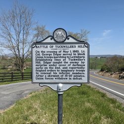
Battle of Tuckwiller's Hill Historical Marker
1 review
I-64 Westbound Welcome Center
2 reviews
Lewisburg Historical Marker
1 review
Department Of Motor Vehicles
2 reviews
Ronceverte Historical Marker
1 review