Imperial Sand Dunes Photos


You might also consider
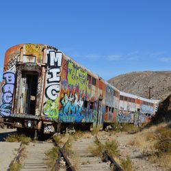
More like Imperial Sand Dunes
Recommended Reviews - Imperial Sand Dunes
Start your review...

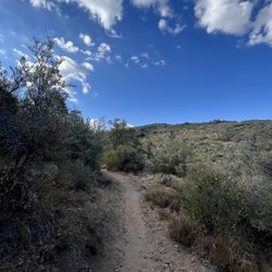
Most know about the White Sands National Park, but the Imperial Sand Dunes in way Southern California shouldn't be slept on either! We came to the Hugh T. Osborne lookout area here and it was so gorgeous! You can park along the incline or drive all the way up and walk around on the dunes. A local told us the dunes span 250 square miles of this area- that's more square footage than the entire city of Chicago takes up! All you see for miles and miles are sand dunes and the mountains way in the distance. It feels like a whole other world, and not one I ever really knew existed in the U.S. At this lookout they have some bathrooms (very bare bones and no way to wash your hands after which seems a little crazy), and a single covered picnic table to sit at. There are garbages as well. But seriously, it is so gorgeous here even when us rookies came in the midst of the hottest time of year (aka off season), which can also be dangerous with all the wildlife coming out during the hot times. But hey, we didn't see any and thoroughly enjoyed the serene view and eerily quiet atmosphere. El Centro is a small city nearby that is really cute and nice of you need another place to stop- or Yuma on the Arizona side. This place is worth a little road trip to see! read more


More info about Imperial Sand Dunes


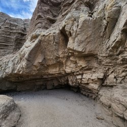


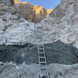


Imperial Sand Dunes - hiking - Updated June 2026
Best of Brawley
People found Imperial Sand Dunes by searching for…
Running Trails in Brawley, California
Fishing Spots in Brawley, California
Sand Dunes in Brawley, California
Hiking Trails in Brawley, California
Playgrounds in Brawley, California
Scenic Drive in Brawley, California
Things to Do in Brawley, California
Walking Trails in Brawley, California
Off Road Trails in Brawley, California
Sunset View in Brawley, California
Playgrounds for Kids in Brawley, California
Secret Spots in Brawley, California
Swimming Lakes in Brawley, California
Fun Things to Do at Night in Brawley, California
Lakes & Ponds in Brawley, California
View Points in Brawley, California
Lookout Points in Brawley, California
Picnic Spots in Brawley, California
Easy Hikes in Brawley, California
Trending Searches in Brawley, CA
Bounce House Rentals near Imperial Sand Dunes
Flower Fields near Imperial Sand Dunes
Flower Shop near Imperial Sand Dunes
Lakes near Imperial Sand Dunes
Movie Theatre near Imperial Sand Dunes
Nurseries & Gardening near Imperial Sand Dunes
Outdoor Furniture Stores near Imperial Sand Dunes
Parks near Imperial Sand Dunes
Pedicure near Imperial Sand Dunes
Picnic Areas near Imperial Sand Dunes
Pool Supplies near Imperial Sand Dunes
Running Trails near Imperial Sand Dunes
Summer Camps near Imperial Sand Dunes
Swimming Pools near Imperial Sand Dunes
Browse Articles
Browse Nearby
Browse Brands
Related Searches in Brawley, CA
Best Fishing Locations and Guides in Brawley, California
Best Fun Things to Do in Brawley, California
Best Nature Trails for Hiking in Brawley, California
Best Places for Horseback Riding in Brawley, California
Best Spots for Star Gazing in Brawley, California
Best Waterfalls and Swimming Holes in Brawley, California
Check Out Off Road Trails in Brawley, California
Discover Dog Friendly Trails to Explore in Brawley, California
Discover a Hiking Trail in Brawley, California
Discover the Best Night Hike Trails in Brawley, California
Dog-Friendly Hikes With Dogs in Brawley, California
Enjoy Camping Adventures Around Brawley, California
Enjoy Exciting Mountain Biking Adventures in Brawley, California
Enjoy Tent Camping Spots Around Brawley, California
Enjoy the Best Walking Trails in Brawley, California
Experience Stunning Sunset Views in Brawley, California
Explore Beautiful Parks and Green Spaces in Brawley, California
Explore Bike Rentals Throughout Brawley, California
Explore Easy Hikes Perfect for All in Brawley, California
Explore Fun Activities to Do in Brawley, California
Explore Jet Skis for Sale or Rent in Brawley, California
Explore Popular Campgrounds Near Brawley, California
Explore Popular RV Parks Around Brawley, California
Explore Popular View Points Around Brawley, California
Explore Scenic Lakes to Visit in Brawley, California
Explore Secret Spots Worth Visiting in Brawley, California
Explore Top Dog Parks in Brawley, California Near You
Explore Top Water Parks in Brawley, California Today
Explore the Best Swimming Holes Around Brawley, California
Explore the Best Trail Options in Brawley, California
Find Beautiful Views in Brawley, California
Find Fun Things to Do With Kids in Brawley, California
Find Popular Ziplining Spots Around Brawley, California
Find the Best Playgrounds to Visit in Brawley, California
Find the Best Scenic View Locations in Brawley, California
Find the Best Swimming Pools in Brawley, California Today
Great Places to Swim in Brawley, California
Plan a Scenic Drive Route Near Brawley, California
Popular Fishing Spots to Explore in Brawley, California
Popular Kids Activities in Brawley, California
Popular Picnic Spots to Visit in Brawley, California
Popular Places to Take Pictures in Brawley, California
Popular Things to Do in Brawley, California
See Top Fireworks Events in Brawley, California
Top Climbing Spots and Gyms in Brawley, California
Top Playgrounds for Kids to Enjoy in Brawley, California
Top Running Trails to Explore in Brawley, California
Top Swimming Lakes to Enjoy in Brawley, California
Top-Rated Basketball Courts to Play at in Brawley, California