Leprechaun Canyon Photos


You might also consider
More like Leprechaun Canyon
Recommended Reviews - Leprechaun Canyon
Start your review...

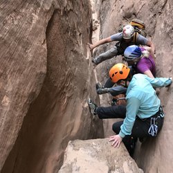
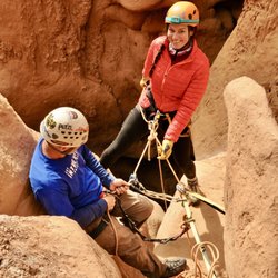
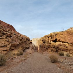
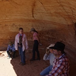
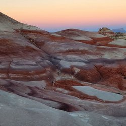
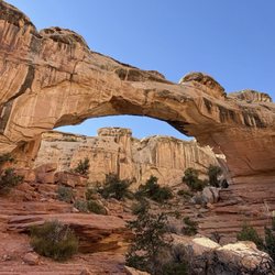
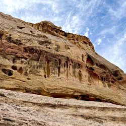
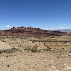
A wonderland of looming slot canyons and strange rock formations - Leprechaun Canyon is the smallest of the Irish Canyons to explore in Southern Utah - but totally worth it and more easily accessible than most (at least for the first mile or so). The trails are along the North Wash and are sandy and overgrown with willows, cottonwoods, and all sorts of other desert plants. It was windy when I hiked and the rustling of the leaves was delightful as I trudged through the sand. I can see how this would be quite treacherous in the rainy season - the area is prone to flash floods so be careful and keep an eye on the weather. Once you're deep in these canyons, it's hard to get out unless you've got mad Spidey-skills! These canyons are great for all levels from novice hikers up to pro canyoneers. They even filmed part of 127 Hours in part of this particular canyon! You can experience quite a few slot canyons along the way on a mostly flat trail with little effort. But after about 1.5 miles, the slots narrow to the point where you can't go any further and you have to either backtrack or climb out. Just be aware of your skills and you'll have a blast exploring. There's lots to see and do in this area - especially if you love those Utah deserts. This trail has dirt parking right off a main paved road and is easy to find - just plug it into google maps and double check it with AllTrails. No bathrooms though :/ I recommend you download the offline maps before you go bc signal is virtually nonexistent once you get into the canyons and even before that. Bring lots of water too - especially in the hot seasons. read more


More info about Leprechaun Canyon
UT-95
Hanksville, UT 84734
Directions
Hours
Outdoor Amenities


Leprechaun Canyon - hiking - Updated July 2026
Best of Hanksville
Browse Brands
Related Searches in Hanksville, UT
Affordable Long Term RV Parking in Hanksville, Utah
Best Fishing Locations and Guides in Hanksville, Utah
Best Lookout Points to Visit in Hanksville, Utah
Best Nature Trails for Hiking in Hanksville, Utah
Best Places for Horseback Riding in Hanksville, Utah
Best Places for Stunning Views in Hanksville, Utah
Check Out Off Road Trails in Hanksville, Utah
Discover Popular Bike Trails in Hanksville, Utah
Discover Scenic Creeks to Explore in Hanksville, Utah
Discover Top Nature Parks to Visit in Hanksville, Utah
Discover a Hiking Trail in Hanksville, Utah
Enjoy Camping Adventures Around Hanksville, Utah
Enjoy Exciting Mountain Biking Adventures in Hanksville, Utah
Enjoy Scenic Night View Experiences in Hanksville, Utah
Enjoy Tent Camping Spots Around Hanksville, Utah
Enjoy the Best Night View Spots in Hanksville, Utah
Enjoy the Best Picnic Spots and Ideas in Hanksville, Utah
Enjoy the Best Walking Trails in Hanksville, Utah
Exciting Cliff Jumping Spots in Hanksville, Utah
Experience Stunning Sunset Views in Hanksville, Utah
Explore Beautiful Parks and Green Spaces in Hanksville, Utah
Explore Bike Rentals Throughout Hanksville, Utah
Explore Easy Hikes Perfect for All in Hanksville, Utah
Explore Free Picnic Areas Around Hanksville, Utah
Explore Popular Boat Charters Near Hanksville, Utah
Explore Popular Campgrounds Near Hanksville, Utah
Explore Popular RV Parks Around Hanksville, Utah
Explore Popular Scenic Overlook Points in Hanksville, Utah
Explore Popular View Points Around Hanksville, Utah
Explore Secret Spots Worth Visiting in Hanksville, Utah
Explore the Best Swimming Holes Around Hanksville, Utah
Explore the Best Trail Options in Hanksville, Utah
Family Friendly Hiking With Kids in Hanksville, Utah
Find Beautiful Views in Hanksville, Utah
Find Cozy Camping Cabins in Hanksville, Utah
Find Parks and Recreation Activities in Hanksville, Utah
Find the Best Scenic View Locations in Hanksville, Utah
Hiking Trails With Waterfalls in Hanksville, Utah
Locate a Public Shower Facility in Hanksville, Utah
Must-See Tourist Attractions Around Hanksville, Utah
Perfect Spots to Watch Sunset in Hanksville, Utah
Plan Nature Center Visits in Hanksville, Utah
Plan a Scenic Drive Route Near Hanksville, Utah
Popular Places to Take Pictures in Hanksville, Utah
Popular Things to Do in Hanksville, Utah
Relax at Natural Hot Springs Near Hanksville, Utah
Top RV Campgrounds to Visit in Hanksville, Utah