Cancel

    Open app

    Search

    NASA Tracking Historical Marker

    3.0 (1 review)

    NASA Tracking Historical Marker Photos

    More like NASA Tracking Historical Marker
    Recommended Reviews - NASA Tracking Historical Marker

    Your trust is our priority, so businesses can't pay to alter or remove their reviews. Learn more about reviews.
    Yelp app icon
    Browse more easily on the app
    Review Feed Illustration
    Photo of Bruce K.
    2415
    25973
    76311

    7 years ago

    Helpful 6
    Thanks 0
    Love this 6
    Oh no 0

    Verify this business for free

    Get access to customer & competitor insights.

    Verify this business

    High Falls Covered Bridge - High Falls Covered Bridge, Cedar Mountain

    High Falls Covered Bridge

    5.0(2 reviews)
    21.1 km

    Big thanks to Richard R. for adding this one that did not come up in the usual searches and yet, it…read morewas the main reason I passed through the DuPont Forest. I love bridges and I love covered bridges even more! And wow, thanks for the amazing writeup of all the drama on this property that was an eye-opener. I parked the van at the High Falls Trailhead (there are restrooms and even a wifi here!) and made my way along the trail to the bridge. It's about 0.75 of a mile on a path through the woods. I am apparently not as delicious as usual as I earned zero mosquito bites despite sweating a lot in the humidity. I'd call this walk "easy plus." The bridge itself is impressive and quite modern. And I would suggest not missing the nearby Falls though I was simply too tired and it was getting too late for me. I'll need to plan better next time! The walk back was much easier as I opted to take the gravel road that is easy and smooth, but only open for emergency vehicles and the forest rangers. I would rate the hike as "easy" for 0.6 miles though not wheelchairable. You can ask the rangers for access by vehicle for handicapped but they're only open regular hours. [Review 20030 overall - 3463 in North Carolina - 1005 of 2023.]

    High Falls Covered Bridge (also known as Buck Forest Covered Bridge) is one of my favorite bridges…read morein the Southern United States. It is a modern structure that has an interesting history. It is an example of the power of the people versus the dollar power of a developer. HISTORY In 1999, Sterling Diagnostic Imaging decided to sell their interest in the land that holds Triple Falls and High Falls, two of the most gorgeous waterfalls you will ever visit this side of the Mississippi. For reasons still unknown, the company decided to use an unusual bidding method by choosing to keep the bidding private and secretive. The State offered up a bid in efforts to save the land for public use, but Sterling announced a developer by the name of Jim Anthony won with a bid of 6.35 million. The developer initially announced in the Hendersonville Times News that he had no plans to develop the land, but instead wanted to use it as a private retreat. However, it soon became apparent Anthony was indeed planning a massive upscale gated community. The fact that the deed he purchased from Sterling Diagnostics stating the land could not be used for residential purposes at the Transylvania Courthouse did not seem to matter. It was later discovered the complex legal agreement between the two was unenforceable and the battle began between the state and Anthony. Anthony proceeded to begin building the roads and this gorgeous covered bridge as part of his planned community, but thankfully he was ultimately defeated. On October 23, 2000 Governor Jim Hunt and the Council of State unanimously voted to invoke eminent domain on the tract of land owned by developer Anthony. In many ways Anthony still won big, because the State paid him 24.5 million dollars in an out of court settlement. WOW! The Falls opened to the public on December 17, 2000. Since then, the entire 2200 acres has been integrated into Dupont State Forest. [History Reference: Romantic Asheville - "How Dupont State Forest was saved"] FINAL THOUGHTS Aside from being one of the most beautiful covered bridges you will ever see, it also is part of a trail system that includes arguably the most beautiful waterfalls in the South. If that is not enough of a reason to come here, let me give you movie fans one more reason. Many scenes from the 1st Hunger Games were filmed right here in this forest. The scene were Katniss finds Peeta camouflaged in the ground at the waterfall is located on the second tier of Triple Falls... just a half mile downstream of High Falls Covered Bridge. Movie scene: https://www.youtube.com/watch?v=UxvyMiwhJWw Year Built: 2000 Obvious materials: Wood, stone, concrete Spans over: Little River at the top of High Falls Location: Dupont State Forest @ Buck Forest Road

    Photos
    High Falls Covered Bridge - High Falls Covered Bridge, Cedar Mountain

    High Falls Covered Bridge, Cedar Mountain

    High Falls Covered Bridge - High Falls Covered Bridge, Cedar Mountain

    High Falls Covered Bridge, Cedar Mountain

    High Falls Covered Bridge - Lots of riders use the trails, so your chances of seeing a group on horseback is pretty good!

    See all

    Lots of riders use the trails, so your chances of seeing a group on horseback is pretty good!

    Revolutionary War Graveyard - Revolutionary War Graveyard, Dandridge

    Revolutionary War Graveyard

    5.0(2 reviews)
    110.4 km

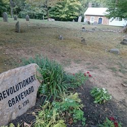
    There's a very helpful brochure at the entrance and if they're out of stock, I've added a picture…read more The brochure tells the story of this cemetery that dates back to 1785 when the oldest church in the county was organized by Scots-Irish in a log building that stood at the north side of the graveyard called Francis Dean's or Robert Henderson's Lower Meeting House. Dean owned the land and Henderson was the first pastor of the church. The brochure continues, "When the church was founded in 1785, Dandridge was just a small western outpost nestled along the French Broad River in Caswell County, State of Franklin, where most people were living in scattered log cabins. The ace of cession by North Carolina paved the way for the formation of the State of Franklin which almost became the nation's 14th state and survived for four years under its own government even though North Carolina would never officially recognize the Franklinites." It was peaceful and interesting and quite historic. If you're heading to Dandridge, stop in and visit the final resting place of these pioneers. [Review 20105 overall - 461 in Tennessee - 1081 of 2023.]

    So old. Yeah, this is pretty neat. Dating back to around 1785, interred here are the graves of…read moreRevolutionary War veterans and early citizens of Dandridge. The are only a handful of headstones and they are all unmarked and weathered - in a really cool historic way. There are several stone benches and the grounds are well maintained. The local attendant at the visitor center told me much more oral history; apparently you may never guess it by the size of this little hill mound but approximately 200 unknown graves lie underneath. Oh my.

    Photos
    Revolutionary War Graveyard - Revolutionary War Graveyard, Dandridge

    Revolutionary War Graveyard, Dandridge

    Revolutionary War Graveyard
    Revolutionary War Graveyard - Revolutionary War Graveyard, Dandridge

    See all

    Revolutionary War Graveyard, Dandridge

    NASA Tracking Historical Marker - landmarks - Updated July 2026
    Loading...
    Loading...
    Loading...