Opossum Creek Falls Trailhead Photos


More like Opossum Creek Falls Trailhead
Recommended Reviews - Opossum Creek Falls Trailhead
Start your review...



7 years ago
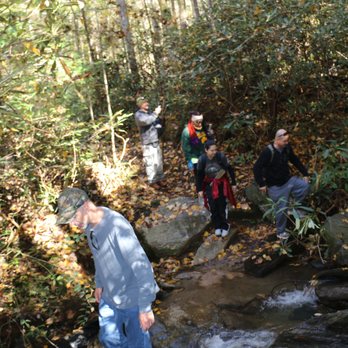
I don't know if it's just that warm & fuzzy time of the year or if my soul is sensing a coming change in my life seasons, but something has my nostalgic side all stirred up! . | THE GROUP HIKE | As promised in my previous review, part of my solo hiking intentions (besides the mind-calming quietness), is to scout out new locations suitable for our group hikes. I thoroughly enjoyed this particular hike because so many people joined us based on pictures they'd seen of previous hikes. Two ladies show up we'd never met before because they saw it under "events" on yelp. A coworkers from a job I haven't worked at for more than 18 years joined us with her family as well as a good friends daughter & her pre-teen son. Also joining us were a few teens and two families from our church + my wife's childhood best friend and her husband... who drove down from Ohio just for the hike. It was a day filled with joyful moments and laughs as everyone got along so well it almost felt like one family. The beauty of a large group is the group itself seems to separate into hiking styles. Some lead, some trail further behind and some are always right in the middle, each faction taking care of its own members. What I love about bringing new hikers that don't get out into nature often is the FRESHNESS & EXCITEMENT they bring to the hike. More than half the group were not regular hikers and EVERYTHING seems to awe them with wonder. Take the Chattooga River for example. We arrived @ the river about 2.25 miles from the parking area and about .25 miles before we turn upstream to Opossum Falls. After showing the group where to cross over the creek to a small sand island, they were so in love with the big river views that I had a hard time getting them to continue to the falls! This was the first waterfall of the day, and the first waterfall ever for many of them. They were so overjoyed with the flow, sound and beauty of Opossum Creek Falls that we stayed way past our allotted time and had to cancel visiting one of the other 4 waterfalls on the hiking schedule. But no matter, this waterfall is truly worth it! . | THE TRAIL | While Opossum creek is super easy to reach because the 2.5 mile trail is mostly all downhill to the falls, the return trip is a beast. The section closest to the Chattooga River is the steepest, so it manages to take your legs reserve power early into the return trip back to the parking area. Trust me when I say you will feel this trail the next day! 5 miles round trip total. Video link to trail experience: https://www.hdcarolina.com/episode/opossum-creek-falls . | PRO TIPS | * The road to the falls is wide, so you don't feel the anxiety of slipping off the road if a car approaches from the opposite direction. Although it is gravel, it's very smooth and easy on cars. * Parking area can handle over a dozen cars. * Beautiful picture opportunities when the trail meets the Chattooga River. Must cross downed logs to get to the island for best pics. * Once trail meets the river, keep straight through the camping area until you see the sign for the falls. It can be a little confusing since the trail seems to disappear. * Plenty of places for a group to sit near the falls. * Once past the camp area, must cross two small creeks to reach the falls. * NO RESTROOMS * NO PARKING FEES . | FINAL THOUGHTS | The area between Eastern Tennessee, the Western sections of the Carolinas and Northern Georgia is known as the land of 1,000 falls. Oconee County, SC all by itself has some spectacular monsters in its closet. While researching hikes I found well over 30 in this area alone, some with maintained trails, others you have to create your own trail. It would take several weeks of all day hikes to see all of them! Fortunately, Opossum Creek Falls is a beautiful and well maintained trail with a decent parking area. Although the fall is listed as only 50 feet, it certainly looks and feels much larger. Good for families with older children, but toddlers and 5 & 6 year olds may need assistance/carrying on the return. As for me, my heart was filled with the sight of people of all walks and ages enjoying the human experience together in nature. I thought several times during our hike "What a wonderful world it would be if we could ALL come together like this." Enjoy!!! 2019 / 135th review read more




More info about Opossum Creek Falls Trailhead

















Opossum Creek Falls Trailhead - landmarks - Updated August 2026
Best of Long Creek
People found Opossum Creek Falls Trailhead by searching for…
Hiking Trails With Waterfalls in Long Creek, SC
Swimming Holes in Long Creek, SC
Things to Do in Long Creek, SC
Places to Take Pictures in Long Creek, SC
Scenic Overlook in Long Creek, SC
Plantation Tours in Long Creek, SC
Off Road Trails in Long Creek, SC
Historical Sites in Long Creek, SC
Scenic Drive in Long Creek, SC
Walking Trails in Long Creek, SC
Things to See in Long Creek, SC
Natural Hot Springs in Long Creek, SC
River Swimming in Long Creek, SC
Browse Nearby
BEST of Long Creek, South Carolina Things to Do near Opossum Creek Falls Trailhead
BEST of Long Creek, South Carolina Restaurants near Opossum Creek Falls Trailhead
BEST of Long Creek, South Carolina Breakfast near Opossum Creek Falls Trailhead
BEST of Long Creek, South Carolina Hotels near Opossum Creek Falls Trailhead
BEST of Long Creek, South Carolina Campgrounds near Opossum Creek Falls Trailhead
BEST of Long Creek, South Carolina Fishing near Opossum Creek Falls Trailhead


