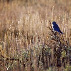
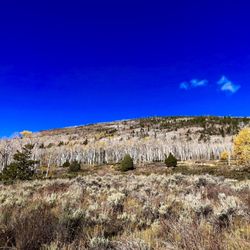
Otter Creek State Park Photos


More like Otter Creek State Park
Recommended Reviews - Otter Creek State Park
Start your review...

8 years ago
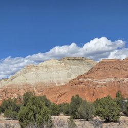
We went to Otter Creek State Park. There is a nice place to go fishing and enjoy the views. There is also a campground. Many were there enjoying the state park. read more


More info about Otter Creek State Park


Otter Creek State Park - parks - Updated June 2026
Best of Antimony
People found Otter Creek State Park by searching for…
Things to Do in Antimony, Utah
Swimming Holes in Antimony, Utah
Places to Swim in Antimony, Utah
Picnic Areas in Antimony, Utah
Fishing Spots in Antimony, Utah
Fishing Lake in Antimony, Utah
Places to Take Pictures in Antimony, Utah
Camping Sites in Antimony, Utah
Picnic Spots in Antimony, Utah
Watch Sunset in Antimony, Utah
Walking Trails in Antimony, Utah
Swimming Lakes in Antimony, Utah
Lakes & Ponds in Antimony, Utah
Running Trails in Antimony, Utah
Scenic Drive in Antimony, Utah
Beautiful Views in Antimony, Utah
Tourist Attractions in Antimony, Utah
Browse Articles
Browse Brands
Related Searches in Antimony, UT
Best Fishing Locations and Guides in Antimony, Utah
Best Places for Horseback Riding in Antimony, Utah
Best Places for Stunning Views in Antimony, Utah
Best Spots for Star Gazing in Antimony, Utah
Check Out Great Playgrounds in Antimony, Utah
Check Out Off Road Trails in Antimony, Utah
Discover Fun Recreation Activities in Antimony, Utah
Discover Popular Bike Trails in Antimony, Utah
Discover Popular Photo Spots in Antimony, Utah
Discover Top Nature Parks to Visit in Antimony, Utah
Discover the Best Fishing Lake in Antimony, Utah
Discover the Best Night Hike Trails in Antimony, Utah
Dog-Friendly Hikes With Dogs in Antimony, Utah
Effective Stairs Workout Spots in Antimony, Utah
Enjoy Tent Camping Spots Around Antimony, Utah
Enjoy the Best Night View Spots in Antimony, Utah
Enjoy the Best Picnic Spots and Ideas in Antimony, Utah
Enjoy the Best Walking Trails in Antimony, Utah
Exciting Cliff Jumping Spots in Antimony, Utah
Experience Stunning Sunset Views in Antimony, Utah
Explore Beautiful Parks and Green Spaces in Antimony, Utah
Explore Easy Hikes Perfect for All in Antimony, Utah
Explore Free Picnic Areas Around Antimony, Utah
Explore Nature Spots Around Antimony, Utah
Explore Popular Picnic Areas Around Antimony, Utah
Explore Popular Scenic Overlook Points in Antimony, Utah
Explore Popular Scenic Views Near Antimony, Utah
Explore Popular View Points Around Antimony, Utah
Explore Scenic Lakes to Visit in Antimony, Utah
Explore the Best Swimming Holes Around Antimony, Utah
Family Friendly Hiking With Kids in Antimony, Utah
Find Beautiful Views in Antimony, Utah
Find Fun Kids Activities Outdoor in Antimony, Utah
Find Picnic Tables for Outdoor Fun in Antimony, Utah
Find Top Dog Friendly Parks to Visit in Antimony, Utah
Find Top-Rated Waterfalls in Antimony, Utah Now
Find the Best Parks for Picnics in Antimony, Utah
Find the Best Playgrounds to Visit in Antimony, Utah
Great Places to Swim in Antimony, Utah
Hiking Trails With Waterfalls in Antimony, Utah
Perfect Spots to Watch Sunset in Antimony, Utah
Picnic Areas With BBQ Pits Available in Antimony, Utah
Plan a Scenic Drive Route Near Antimony, Utah
Popular Places to Take Pictures in Antimony, Utah
Popular Things to Do in Antimony, Utah
Safe River Swimming Areas in Antimony, Utah
Safe and Fun Parks for Kids in Antimony, Utah
Top Fishing Ponds to Visit in Antimony, Utah