Pecos Historical Park Photos


More like Pecos Historical Park
Recommended Reviews - Pecos Historical Park
Start your review...


When I was searching for things to do in Santa Fe I stumbled upon this park. I was thinking to myself that it looked kind of boring, but it turned out to be a really cool place. Admission is only $3 per person. They give you a pamphlet/laminated book type thing and you follow the trail and read the information as you go. They did an excellent job of describing life at the pueblo and it made the trip super interesting. There is a lot of opportunity for great photos. Dogs are allowed throughout the park as long as they are leashed and picked-up after. They had a movie in the visitor center, which we watched after our walk, it was informative, but not necessary. read more


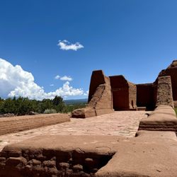
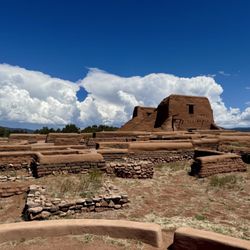
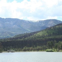
The Pecos Historical Park was a very interesting site with lots to see. I love exploring ruins and the Pecos site didn't disappoint. The museum on-site was also very interesting and did a great job telling the story and history of the area and the people who lived there. Pecos is also in a beautiful area with lots of wilderness, forests, and low mountains surrounding it. It may be out of your way, but Pecos is definitely worth visiting. read more


6 years ago
I have a few words for Azul trail. I recommend when you are injured in general to refrain from hiking. Unless you have lost the trail for three hours. In dealing with sartori tears try to go around fallen trees if you can to lessen the pain. DO NOT FOLLOW AVERAGE HIKERS. read more


19 years ago
This park has ruins from an old pueblo and Spanish missionaries. A trail winds around and a visitor center gives some information on the settlement that once was home to 2,000 people. There are some beautiful mountain views from the park. read more


7 years ago
12 years ago
15 years ago
15 years ago
More info about Pecos Historical Park
Pecos, NM 87552
Directions
(505) 757-6414
Call Now
Visit Website
http://www.nps.gov/peco/
Hours
Indoor Amenities
Outdoor Amenities
Ask the Community - Pecos Historical Park
Review Highlights - Pecos Historical Park


Why does Yelp recommend reviews?
2 reviews that are not currently recommended
The reviews below are not factored into the business's overall star rating.
10 years ago
14 years ago
Pecos Historical Park - parks - Updated June 2026
Best of Pecos
People found Pecos Historical Park by searching for…
Trending Searches in Pecos, NM
Amusement Parks near Pecos Historical Park
Baseball Fields near Pecos Historical Park
Beaches near Pecos Historical Park
Dog Swimming near Pecos Historical Park
Fruit Picking near Pecos Historical Park
Kayak Rental near Pecos Historical Park
Lakes near Pecos Historical Park
Outdoor Basketball Courts near Pecos Historical Park
Pick Your Own Farms near Pecos Historical Park
Playgrounds near Pecos Historical Park
Pool Supplies near Pecos Historical Park
Public Pools near Pecos Historical Park
River Swimming near Pecos Historical Park
River Tubing near Pecos Historical Park
Splash Pad near Pecos Historical Park
Swimming Holes near Pecos Historical Park
Swimming Lakes near Pecos Historical Park
Swimming Pools near Pecos Historical Park
Browse Articles
Browse Nearby
Browse Brands
Related Searches in Pecos, NM
Best Fishing Locations and Guides in Pecos, New Mexico
Best Nature Trails for Hiking in Pecos, New Mexico
Best Off Leash Dog Parks in Pecos, New Mexico
Best Places for Horseback Riding in Pecos, New Mexico
Best Water Parks for Kids in Pecos, New Mexico
Check Out Great Playgrounds in Pecos, New Mexico
Check Out Off Road Trails in Pecos, New Mexico
Discover Baseball Fields Around Pecos, New Mexico
Discover Lakes & Ponds to Explore in Pecos, New Mexico
Discover Popular Bike Trails in Pecos, New Mexico
Discover Top Nature Parks to Visit in Pecos, New Mexico
Discover the Best Night Hike Trails in Pecos, New Mexico
Dog-Friendly Hikes With Dogs in Pecos, New Mexico
Enjoy Scenic Night View Experiences in Pecos, New Mexico
Enjoy the Best Night View Spots in Pecos, New Mexico
Enjoy the Best Picnic Spots and Ideas in Pecos, New Mexico
Enjoy the Best Tubing Experiences in Pecos, New Mexico
Enjoy the Best Walking Trails in Pecos, New Mexico
Explore Free Picnic Areas Around Pecos, New Mexico
Explore Landmarks & Historical Buildings in Pecos, New Mexico
Explore Popular Picnic Areas Around Pecos, New Mexico
Explore Popular RV Parks Around Pecos, New Mexico
Explore Popular Scenic Overlook Points in Pecos, New Mexico
Explore Popular Scenic Views Near Pecos, New Mexico
Explore Scenic Lakes to Visit in Pecos, New Mexico
Explore Secret Spots Worth Visiting in Pecos, New Mexico
Explore Top Dog Parks in Pecos, New Mexico Near You
Explore Top Gyms in Pecos, New Mexico Now
Explore the Best Swimming Holes Around Pecos, New Mexico
Find Beautiful Views in Pecos, New Mexico
Find Parks and Recreation Activities in Pecos, New Mexico
Find Picnic Tables for Outdoor Fun in Pecos, New Mexico
Find Top Dog Swimming Spots in Pecos, New Mexico
Find the Best Parks for Picnics in Pecos, New Mexico
Find the Best Swimming Pools in Pecos, New Mexico Today
Have Fun at a Splash Pad in Pecos, New Mexico
Must-See Tourist Attractions Around Pecos, New Mexico
Parks With Basketball Courts for Games in Pecos, New Mexico
Perfect Spots to Watch Sunset in Pecos, New Mexico
Picnic Areas With BBQ Pits Available in Pecos, New Mexico
Popular Fishing Spots to Explore in Pecos, New Mexico
Popular Things to Do in Pecos, New Mexico
Popular Things to See in Pecos, New Mexico
Safe River Swimming Areas in Pecos, New Mexico
Top Hiking Trails to Explore in Pecos, New Mexico
Top Running Trails to Explore in Pecos, New Mexico
Top Swimming Lakes to Enjoy in Pecos, New Mexico
Top-Rated Hikes in Pecos, New Mexico to Explore
People who viewed Pecos Historical Park also viewed
Santa Fe Canyon Interpretive Loop
2 reviews
La Cieneguillia Petroglyph site
4 reviews
Randall Davey Cntr Audubon Society
6 reviews
Cerrillos Hills State Park
4 reviews
Ragle Park
4 reviews
Railyard Park and Plaza
9 reviews
Frenchies Field Park
1 review
Arroyo Hondo Open Space
2 reviews
Frank S Ortiz Dog Park
52 reviews
Pendaries RV Resort
11 reviews