Ramsey Cascades Photos


More like Ramsey Cascades
Recommended Reviews - Ramsey Cascades
Start your review...

Reviews With Photos - Ramsey Cascades

This is a really great trail to take. Definitely longer than 8 miles out and back. I think it was closer to 9. It took us 2 hours to get up and then 2 hours to come back, which was surprising. We were walking at a fast clip, and enjoyed the hike. Definitely gets more challenging after the first mile and a half. Did not require you to use your hands to support you, but there were some big steps. The trail was well-maintained and marked. The waterfalls at the top are definitely worth the effort. Wish we could come back in the summer so that we could enjoy the creek a little. There are lots of opportunities where you need to cross the creek and it would be fun if you could get your feet wet. There is a small parking area at the end of the road, right by the trail. But the road in from the main road is long, it probably took us 15 minutes once we entered the park.

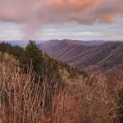
This is the most difficult hike I have ever done... hands down! I both hate this trail and love this trail! I am not sure of the difficulty rating, but I would venture to say it is listed as VERY STRENUOUS. I should start off by saying I was a bad, bad boy today. You see, there was a bulletin stating the trail was closed for bridge repairs, but my entire reason for coming to Gatlinburg was to: A) hike to the summit of Mount LeConte and B) hike the 8 mile loop to lay my eyes on Ramsey Cascades. It's the only large waterfall I had not yet seen in the Gatlinburg area. So I located a park ranger and asked him if there was any way I could still cross the river with the bridge being out. His semi-surly response was: "Well, you could wade through the water." "I'm allowed to do that?" I asked. "I can't tell you not to, but the water levels are up from all the recent rains." Well, that was all I needed to know, because I was bound and determined to see this waterfall come hell or high water. I would have left feeling defeated had I not given it a shot. THE EXPERIENCE The first two miles of this trail is gravel coated. There are still a lot of large rock outcroppings that serve as tripping hazards, but otherwise a comfortable walk. You should be forewarned the entire trail is ALL uphill. The gravel part is the easiest section of the trail with the least elevation gain. At about the 2 mile mark you will see a sign stating the remainder of the trail to Ramsey Cascades is 2.5 miles. Here is where the gravel road ends and a much more strenuous uphill climb begins. The bridge that was supposedly out was about 1/4 of a mile from this sign. Trail workers I encountered along the way told me it had a crack in the middle. After slowly walking out to test it, I felt confident it was capable of supporting my weight... so I risked it and skedaddled on across. I knew from here I would be on my own! Why? No other idiot would dare venture past the bridge and likely would heed the "trail closed" signs back at the parking area. I was going to be by myself for the next 2.25 miles and to be honest, I was a little afraid. Would I run across a black bear or pack of wolves? Would I trip and sprain my ankle or worse, break a leg? As a precaution, I found a large stick to carry with me and stopped often to listen for any noises that indicated something large might be nearby. After the bridge, the trail is outright BRUTAL. So brutal the park has installed stone steps in some of the more severe incline areas. They are nothing fancy, but they do the job. Shortly after passing over the bridge you'll come to an old growth area of Poplar Trees. Some were so big in circumference that it would take 6 people hand in hand to circle the largest of the group. Most of the trail follows the river, so the loud sounds of the cascades stay with you most of the hike. However, there is one area where the trail drifts away from the river and it becomes very quiet. My imagination had me thinking this would be the perfect spot for Red Riding Hoods grandmother's house. It was here I took a break. It was also here I debated on turning back. I was suffering from leg cramps, hunger, exhaustion and didn't know how much further I had to go. After a power bar and the last of my water, I hiked about 10 more minutes until I came to a different creek and a huge wall of stone. It was unclear which way the trail was leading, but as I navigated around the huge stone, the waterfall comes into view about 80 yards away. I was so relieved I almost collapsed with excitement. Ramsey Cascade is approximately 100 feet tall with multiple ledges creating a truly dramatic and picturesque waterfall as the water tumbles down its surface. Definitely qualifies as one of my favorites in the park, but Abram Falls still holds top honors. THE VERDICT I thought after going all uphill it would be a piece of cake going back down. Unfortunately that isn't true. Some of my most severe cramping happened in my quadriceps going downhill instead of my hamstrings going uphill. However, it's a beautiful waterfall and I'm happy to finally cross it off my list. MY STATS Elevation gain - 2375 Feet (593.5 feet average per mile) I would say 80% of the elevation gain happens in the last 2.5 miles! Trail Difficulty: VERY strenuous Total miles round trip: 8 Ascent time: 2h 9m Descent time: 1h 54m Total hike time: 4h 20m w/rest break @ falls ---------- NOTE: The Little Pigeon River along the road to the parking area has some AMAZING views, especially early in the morning. Here is my favorite photo taken around 7:45 am: http://www.yelp.com/biz_photos/ramsey-cascades-gatlinburg?select=D_lUVQwQckwUUjGpfvcgqw

Ok , read all the reviews on this trail and here is mine !! We hiked this trail on a Saturday and the temp was 75 and sunny . My wife and I are both 55 and the couple we hike with are in their early 60s , also my wife had a knee replacement 2 years ago !! We started the hike at day break and took us roughly 3.5 hrs to the top , the trail is absolutely beautiful, but if u are not in DECENT shape don't try it , we passed several people that gave up early on !! The total hike was about 9 miles and took approximately 6.5 hrs , slo the hike down was more tuff on my wife's knee so we took it a little slower !!! I highly recommend this hike , but it will kick your butt

Very nice hike. Took us 4 hours round trip to complete the hike. In October, the fall colors are amazing. Didn't feel like it was as strenuous as others stated. It is a tough hike but there are definitely harder ones out there. The last 20 minutes before the falls are the toughest but the end is worth it!

First i want to so that this is by far the most spectacular waterfall I have visited. Its huge, it beautiful and the trail to get there was just about the hardest thing I've done in a long time. The first mile and a half is a piece of cake, then things start to get real, by that I mean rugged and steep. Just when you think it can't get any harder, that's exactly what it does, it gets more steep and more rugged. The last third of the forth mile, it gets worse. I wanted to turn back more than once. With all that being said, the fall at the end was absolutely worth it, my husband told me to take lots of pictures cause we were never doing this trail again. But in a year he'll forget the pain and suffering, I might get him to do it again, we'll see. Definitely take something to eat once you reach the fall and lots of water. Good luck!


I have to disagree with the previous review on a few minor details, but overall, super accurate. The gravel road: it is the easiest part of the trail obstacle wise- you're not searching for where to put your foot next, or for a conveniently located tree to pull yourself up with, however- the first .75 miles of the gravel road is STEEP, and one of the longer steep trecks on the hike. Do not be disheartened! The whole hike will not be so bad. The rest of the super steep stretches are broken up somewhat with flat stretches along the way. 2nd, this is not an 8 mile round trip hike. It's closer to 9 miles. Like he said, the first two miles are gravel, and THEN you get to the 2.5 mile marker--- which means it's 4.5 miles either way. So if you're like me, and you're tracking when you hit 4 miles, you're going to be super disappointed to find yourself nowhere near the waterfall. Just keep going. Believe me. It's worth it. The last half mile up to the waterfall is probably the worst. If you don't have both hands and feet in good working condition I don't recommend you try this. This is my second time at it, and I carried my 7 month old daughter up the mountain with me, and it was a real challenge. I don't recommend bring children- teenager is probably the youngest I would venture could make this climb. Make sure you pack a picnic so you can hang out at the waterfalls for awhile and relax once you get there. The climb down is much quicker but harder on your bones. Once again, totally worth it. This is my favorite climb in all of the smokeys. I highly recommend it.

7 years ago


6 years ago
We took our four kids and a cousin up this trail. (18yo, 17yo, 15yo, 13yo and 10yo) we made it up in 2.5hrs and down in 1.5hrs. This trail was epic. Kids were dragging some on our way up but all said it was worth it. Bring water, snacks, great shoes and be ready to get a great workout in. read more


This is a really great trail to take. Definitely longer than 8 miles out and back. I think it was closer to 9. It took us 2 hours to get up and then 2 hours to come back, which was surprising. We were walking at a fast clip, and enjoyed the hike. Definitely gets more challenging after the first mile and a half. Did not require you to use your hands to support you, but there were some big steps. The trail was well-maintained and marked. The waterfalls at the top are definitely worth the effort. Wish we could come back in the summer so that we could enjoy the creek a little. There are lots of opportunities where you need to cross the creek and it would be fun if you could get your feet wet. There is a small parking area at the end of the road, right by the trail. But the road in from the main road is long, it probably took us 15 minutes once we entered the park. read more

12 years ago
This is the most difficult hike I have ever done... hands down! I both hate this trail and love this trail! I am not sure of the difficulty rating, but I would venture to say it is listed as VERY STRENUOUS. I should start off by saying I was a bad, bad boy today. You see, there was a bulletin stating the trail was closed for bridge repairs, but my entire reason for coming to Gatlinburg was to: A) hike to the summit of Mount LeConte and B) hike the 8 mile loop to lay my eyes on Ramsey Cascades. It's the only large waterfall I had not yet seen in the Gatlinburg area. So I located a park ranger and asked him if there was any way I could still cross the river with the bridge being out. His semi-surly response was: "Well, you could wade through the water." "I'm allowed to do that?" I asked. "I can't tell you not to, but the water levels are up from all the recent rains." Well, that was all I needed to know, because I was bound and determined to see this waterfall come hell or high water. I would have left feeling defeated had I not given it a shot. THE EXPERIENCE The first two miles of this trail is gravel coated. There are still a lot of large rock outcroppings that serve as tripping hazards, but otherwise a comfortable walk. You should be forewarned the entire trail is ALL uphill. The gravel part is the easiest section of the trail with the least elevation gain. At about the 2 mile mark you will see a sign stating the remainder of the trail to Ramsey Cascades is 2.5 miles. Here is where the gravel road ends and a much more strenuous uphill climb begins. The bridge that was supposedly out was about 1/4 of a mile from this sign. Trail workers I encountered along the way told me it had a crack in the middle. After slowly walking out to test it, I felt confident it was capable of supporting my weight... so I risked it and skedaddled on across. I knew from here I would be on my own! Why? No other idiot would dare venture past the bridge and likely would heed the "trail closed" signs back at the parking area. I was going to be by myself for the next 2.25 miles and to be honest, I was a little afraid. Would I run across a black bear or pack of wolves? Would I trip and sprain my ankle or worse, break a leg? As a precaution, I found a large stick to carry with me and stopped often to listen for any noises that indicated something large might be nearby. After the bridge, the trail is outright BRUTAL. So brutal the park has installed stone steps in some of the more severe incline areas. They are nothing fancy, but they do the job. Shortly after passing over the bridge you'll come to an old growth area of Poplar Trees. Some were so big in circumference that it would take 6 people hand in hand to circle the largest of the group. Most of the trail follows the river, so the loud sounds of the cascades stay with you most of the hike. However, there is one area where the trail drifts away from the river and it becomes very quiet. My imagination had me thinking this would be the perfect spot for Red Riding Hoods grandmother's house. It was here I took a break. It was also here I debated on turning back. I was suffering from leg cramps, hunger, exhaustion and didn't know how much further I had to go. After a power bar and the last of my water, I hiked about 10 more minutes until I came to a different creek and a huge wall of stone. It was unclear which way the trail was leading, but as I navigated around the huge stone, the waterfall comes into view about 80 yards away. I was so relieved I almost collapsed with excitement. Ramsey Cascade is approximately 100 feet tall with multiple ledges creating a truly dramatic and picturesque waterfall as the water tumbles down its surface. Definitely qualifies as one of my favorites in the park, but Abram Falls still holds top honors. THE VERDICT I thought after going all uphill it would be a piece of cake going back down. Unfortunately that isn't true. Some of my most severe cramping happened in my quadriceps going downhill instead of my hamstrings going uphill. However, it's a beautiful waterfall and I'm happy to finally cross it off my list. MY STATS Elevation gain - 2375 Feet (593.5 feet average per mile) I would say 80% of the elevation gain happens in the last 2.5 miles! Trail Difficulty: VERY strenuous Total miles round trip: 8 Ascent time: 2h 9m Descent time: 1h 54m Total hike time: 4h 20m w/rest break @ falls ---------- NOTE: The Little Pigeon River along the road to the parking area has some AMAZING views, especially early in the morning. Here is my favorite photo taken around 7:45 am: http://www.yelp.com/biz_photos/ramsey-cascades-gatlinburg?select=D_lUVQwQckwUUjGpfvcgqw read more

 - Local Flavor Near Me - Gatlinburg, Tennessee")


 - Local Flavor Near Me - Gatlinburg, Tennessee")


Ok , read all the reviews on this trail and here is mine !! We hiked this trail on a Saturday and the temp was 75 and sunny . My wife and I are both 55 and the couple we hike with are in their early 60s , also my wife had a knee replacement 2 years ago !! We started the hike at day break and took us roughly 3.5 hrs to the top , the trail is absolutely beautiful, but if u are not in DECENT shape don't try it , we passed several people that gave up early on !! The total hike was about 9 miles and took approximately 6.5 hrs , slo the hike down was more tuff on my wife's knee so we took it a little slower !!! I highly recommend this hike , but it will kick your butt read more


5 years ago
9 years ago
Very nice hike. Took us 4 hours round trip to complete the hike. In October, the fall colors are amazing. Didn't feel like it was as strenuous as others stated. It is a tough hike but there are definitely harder ones out there. The last 20 minutes before the falls are the toughest but the end is worth it! read more


10 years ago
First i want to so that this is by far the most spectacular waterfall I have visited. Its huge, it beautiful and the trail to get there was just about the hardest thing I've done in a long time. The first mile and a half is a piece of cake, then things start to get real, by that I mean rugged and steep. Just when you think it can't get any harder, that's exactly what it does, it gets more steep and more rugged. The last third of the forth mile, it gets worse. I wanted to turn back more than once. With all that being said, the fall at the end was absolutely worth it, my husband told me to take lots of pictures cause we were never doing this trail again. But in a year he'll forget the pain and suffering, I might get him to do it again, we'll see. Definitely take something to eat once you reach the fall and lots of water. Good luck! read more


6 years ago
This hike is very challenging but so worth it bring snacks and lots of water! Took us 4 hours there and 3 back but definitely a great day hike! read more


I have to disagree with the previous review on a few minor details, but overall, super accurate. The gravel road: it is the easiest part of the trail obstacle wise- you're not searching for where to put your foot next, or for a conveniently located tree to pull yourself up with, however- the first .75 miles of the gravel road is STEEP, and one of the longer steep trecks on the hike. Do not be disheartened! The whole hike will not be so bad. The rest of the super steep stretches are broken up somewhat with flat stretches along the way. 2nd, this is not an 8 mile round trip hike. It's closer to 9 miles. Like he said, the first two miles are gravel, and THEN you get to the 2.5 mile marker--- which means it's 4.5 miles either way. So if you're like me, and you're tracking when you hit 4 miles, you're going to be super disappointed to find yourself nowhere near the waterfall. Just keep going. Believe me. It's worth it. The last half mile up to the waterfall is probably the worst. If you don't have both hands and feet in good working condition I don't recommend you try this. This is my second time at it, and I carried my 7 month old daughter up the mountain with me, and it was a real challenge. I don't recommend bring children- teenager is probably the youngest I would venture could make this climb. Make sure you pack a picnic so you can hang out at the waterfalls for awhile and relax once you get there. The climb down is much quicker but harder on your bones. Once again, totally worth it. This is my favorite climb in all of the smokeys. I highly recommend it. read more


9 years ago
10 years ago
Absolutely great hike! If you are looking for something a bit more difficult, this is it. We had 5 active adults do this hike. For us it was tough, but very rewarding. Then Cascades are so beautiful. During your hike you will walk over two "bridges", really just logs with handrail on one side, and up some difficult rocks. I think that is all part of the experience. I have to say it felt longer than 4 miles because the terrain is difficult, but it is only 4 miles one way. I recommend bringing a hiking stick, water and some fruit for energy. We started at 2 in the afternoon and finished all 8 miles around 7pm. We did relax at the falls for a bit too. read more


More info about Ramsey Cascades
Ask the Community - Ramsey Cascades
Review Highlights - Ramsey Cascades


Ramsey Cascades - localflavor - Updated July 2026
Best of Gatlinburg
People found Ramsey Cascades by searching for…
Things to Do in Gatlinburg, Tennessee
Fun Places for Teens in Gatlinburg, Tennessee
Secret Spots in Gatlinburg, Tennessee
Places to Take Pictures in Gatlinburg, Tennessee
Caves in Gatlinburg, Tennessee
Waterfall in Gatlinburg, Tennessee
Farms in Gatlinburg, Tennessee
Picnic Areas in Gatlinburg, Tennessee
Lookout Points in Gatlinburg, Tennessee
Things to Do at Night in Gatlinburg, Tennessee
View Points in Gatlinburg, Tennessee
Festivals in Gatlinburg, Tennessee
Hiking in Gatlinburg, Tennessee
Night View in Gatlinburg, Tennessee
Scenic Overlook in Gatlinburg, Tennessee
Trails in Gatlinburg, Tennessee
Attractions in Gatlinburg, Tennessee
Bridge in Gatlinburg, Tennessee
To Do in Gatlinburg, Tennessee
Open Early in Gatlinburg, Tennessee
Bonfire in Gatlinburg, Tennessee
Browse Nearby
Browse Brands
Trending Searches in Gatlinburg, TN
Black Owned Nail Salons near Ramsey Cascades
Boat Rental near Ramsey Cascades
Day Trips near Ramsey Cascades
Fireworks near Ramsey Cascades
Jet Ski Rental near Ramsey Cascades
Kayak Rental near Ramsey Cascades
Public Pools near Ramsey Cascades
River Swimming near Ramsey Cascades
Soccer Store near Ramsey Cascades
Splash Pad near Ramsey Cascades
Strawberry Picking near Ramsey Cascades
Swimming Holes near Ramsey Cascades
Swimming Lakes near Ramsey Cascades