Shenandoah County Park Photos


More like Shenandoah County Park
Recommended Reviews - Shenandoah County Park
Start your review...

13 years ago
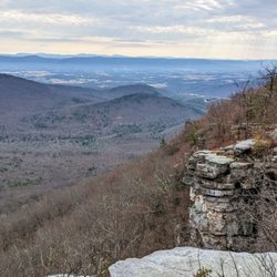
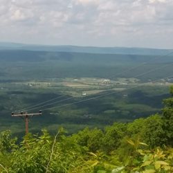
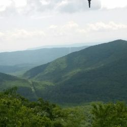
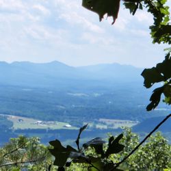
Nice place, I really like the Civil War trails toward the back of the park past all the tennis/basketball courts, baseball fields and playgrounds. The Park is very well taken care of and clean, there is an open area for picnics or football too. For me the stars are for the Civil War trails, walking through the fields and knowing the history that has happened here was just amazing. Worth a Look See if you're looking for an interesting and easy walk. read more


10 years ago
More info about Shenandoah County Park
Park Ln
Maurertown, VA 22644
Directions
Hours
Outdoor Amenities


Shenandoah County Park - hiking - Updated June 2026
Best of Maurertown
People found Shenandoah County Park by searching for…
Things to Do in Maurertown, Virginia
Playgrounds in Maurertown, Virginia
Disc Golf in Maurertown, Virginia
Basketball Courts in Maurertown, Virginia
Hiking Trails in Maurertown, Virginia
Baseball Fields in Maurertown, Virginia
Tennis in Maurertown, Virginia
Picnic Areas in Maurertown, Virginia
Parks for Kids in Maurertown, Virginia
Hiking With Kids in Maurertown, Virginia
Running Trails in Maurertown, Virginia
Easy Hikes in Maurertown, Virginia
Hikes With Dogs in Maurertown, Virginia
Tennis Courts in Maurertown, Virginia
Things to See in Maurertown, Virginia
Photo Spots in Maurertown, Virginia
Attractions in Maurertown, Virginia
Dog Swimming in Maurertown, Virginia
Playgrounds for Kids in Maurertown, Virginia
Parks for Picnics in Maurertown, Virginia
Snow Park in Maurertown, Virginia
Picnic Spots in Maurertown, Virginia
Trending Searches in Maurertown, VA
Black Owned Nail Salons near Shenandoah County Park
Fishing Spots near Shenandoah County Park
Pick Your Own Farms near Shenandoah County Park
Splash Pad near Shenandoah County Park
Strawberry Picking near Shenandoah County Park
Swimming Holes near Shenandoah County Park
Swimming Lakes near Shenandoah County Park
Browse Articles
Browse Nearby
BEST of Maurertown, Virginia Coffee near Shenandoah County Park
BEST of Maurertown, Virginia Restaurants near Shenandoah County Park
BEST of Maurertown, Virginia Things to Do near Shenandoah County Park
BEST of Maurertown, Virginia Parks near Shenandoah County Park
BEST of Maurertown, Virginia Waterfalls near Shenandoah County Park
BEST of Maurertown, Virginia Breakfast near Shenandoah County Park
BEST of Maurertown, Virginia Campgrounds near Shenandoah County Park
BEST of Maurertown, Virginia Taxis near Shenandoah County Park
Browse Brands
Related Searches in Maurertown, VA
Best Fishing Locations and Guides in Maurertown, Virginia
Best Lookout Points to Visit in Maurertown, Virginia
Best Nature Trails for Hiking in Maurertown, Virginia
Best Off Leash Dog Parks in Maurertown, Virginia
Best Parks for Parties and Events in Maurertown, Virginia
Best Spots for Star Gazing in Maurertown, Virginia
Best Water Parks for Kids in Maurertown, Virginia
Best Waterfalls and Swimming Holes in Maurertown, Virginia
Check Out Great Playgrounds in Maurertown, Virginia
Discover Dog Friendly Beaches Near Maurertown, Virginia
Discover Dog Friendly Trails to Explore in Maurertown, Virginia
Discover Lakes & Ponds to Explore in Maurertown, Virginia
Discover Popular Bike Trails in Maurertown, Virginia
Discover Popular Photo Spots in Maurertown, Virginia
Discover Scenic Mountain Bike Trails Near Maurertown, Virginia
Discover Soccer Fields in Maurertown, Virginia Near You
Discover Stunning Skyline View Spots in Maurertown, Virginia
Discover Top Nature Parks to Visit in Maurertown, Virginia
Discover a Hiking Trail in Maurertown, Virginia
Discover the Best Night Hike Trails in Maurertown, Virginia
Dog-Friendly Hikes With Dogs in Maurertown, Virginia
Effective Stairs Workout Spots in Maurertown, Virginia
Enjoy Scenic Night View Experiences in Maurertown, Virginia
Enjoy the Best Night View Spots in Maurertown, Virginia
Enjoy the Best Picnic Spots and Ideas in Maurertown, Virginia
Enjoy the Best Walking Trails in Maurertown, Virginia
Exciting Cliff Jumping Spots in Maurertown, Virginia
Experience Stunning Sunset Views in Maurertown, Virginia
Explore Easy Hikes Perfect for All in Maurertown, Virginia
Explore Free Picnic Areas Around Maurertown, Virginia
Explore Free Things to Do Around Maurertown, Virginia
Explore Landmarks & Historical Buildings in Maurertown, Virginia
Explore Off Leash Dog Beaches in Maurertown, Virginia
Explore Parks With Pull Up Bars in Maurertown, Virginia
Explore Popular Picnic Areas Around Maurertown, Virginia
Explore Popular Scenic Overlook Points in Maurertown, Virginia
Explore Popular Scenic Views Near Maurertown, Virginia
Explore Popular View Points Around Maurertown, Virginia
Explore Scenic Lakes to Visit in Maurertown, Virginia
Explore Secret Spots Worth Visiting in Maurertown, Virginia
Explore Top Dog Parks in Maurertown, Virginia Near You
Explore Top Water Parks in Maurertown, Virginia Today
Explore the Best Swimming Holes Around Maurertown, Virginia
Explore the Best Trail Options in Maurertown, Virginia
Find Beautiful Views in Maurertown, Virginia
Find Parks and Recreation Activities in Maurertown, Virginia
Find Picnic Tables for Outdoor Fun in Maurertown, Virginia
Find Top Dog Friendly Parks to Visit in Maurertown, Virginia