The Watchman Photos


More like The Watchman
Recommended Reviews - The Watchman
Start your review...

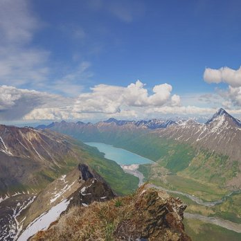
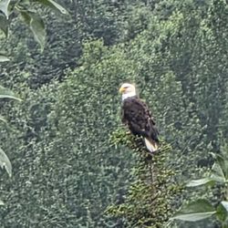
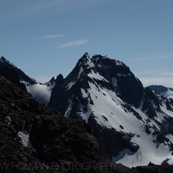
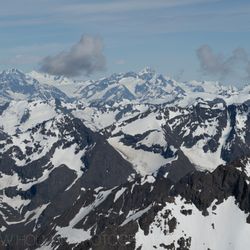
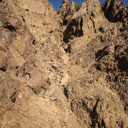
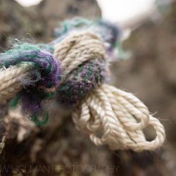
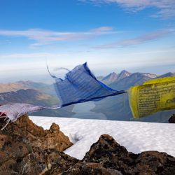
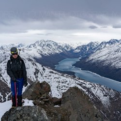
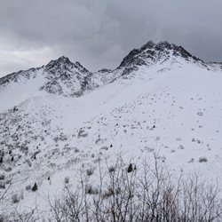
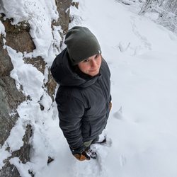
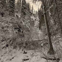
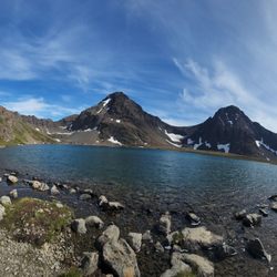
The crux for me on these Eklutna Glacier summits is that I don't have a mountain bike, but Abbey helped me out by renting one for me downtown ahead of time, so we could go right to the trailhead after work on Friday. We cycled in and setup our tent. There was a man and his dog plane-camping there, something I've heard happens at the Bold airstrip, but that I've never witnessed. We decided to get an early start and wakeup around 4:30am. At around 5:30 we were crossing the braids of the Eklutna river. I learned my mountaineering skills in the Pacific NW where you walk across bridges, so every time I cross these in Alaska... it kind of feels like the first time. It was extremely cold and unpleasant. Lucky for us, we had some uphill bushwhacking just ahead to clear our minds and warm us up. I've heard there might be some sort of "trail" up to the ridge of The Watchman, but we didn't find one. I was in front, following weaknesses in the trees. Initially it wasn't that bad, but, before I knew it we were hopping over rubbery tree branches stabbing at us from the slopes. In maybe 3-4 hours (it felt much longer) we were gaining the summit ridge. (Beta note: while I can't vouch for our bushwhacking route-finding, I can vouch for our ridge top-out. Once you can start to see up towards the ridge again, aim for ~61.3160, -149.0299. There is a big grass bench there, great for napping. The slope leading to it is quite moderate.) Once on the ridge, it's straight forward class 2 hiking. At about 61.3126, -149.0290 we left the ridge and started side-hilling to the climber's right (West). The side-hilling eventually turns to a wide grass bench with very comfortable hiking. This would be an amazing spot to make a high camp. (if you enjoy crossing rivers and bushwhacking with overnight gear, that is. There were ample streams for water here, but they seemed like they might be seasonal only.) Eventually the grassy bench ended (~61.3002, -149.0275) and we had to start picking our way up a series of choss gullies and rotting snow tongues. From here, the summit of The Watchman looks close (spoiler: it ain't) and there are great views of Peak 6530 (which I stupidly thought was Benign when I first saw it). The creatively-named peak (there's another peak with the same name, less than a dozen miles from this one) looks like it has some great couloir routes on its north-aspect. After ~1,000 feet of gain we were on the ridge proper. From here, it's mainly 3rd class ridge scrambling. You just have to be mindful of the runouts and not climb up anything that feels harder than that. (unless you want to) After a few false-summit top-outs, we eventually reached the summit proper. The summit area is how we all imagined the tops of mountains were before we actually started climbing them: it's the narrowest, steepest part of the climb with the scariest runout. We stayed on a ridge of increasing narrowness. Finally, we were looking at the last ~80ft. It was a slabby-looking slope off to our right with a thin (maybe 3-5 inches) layer of snow. In front of us, there was gravelly rock spine snaking up to the summit. Abbey mentioned that she didn't feel like going all the way to the summit, and, even though I'm the one with the higher risk tolerance...I definitely agreed with her on this one. It seemed like there wasn't a non-slippery way to the top. Either you go on ball-bearing gravel on top of rock or you go on a thin layer of snow of dubious quality. Abbey mentioned she read some people had gone "around" at this point. I started looking for another way. I found a sensible, short down-climb off of the ridge (climber's left/North). And then we side-hilled around looking for a less-terrible way up. I spotted some tat (the "summit anchor") around a horn and thought that was probably the summit. In front of us was something halfway between a shallow chimney and a narrow gully. After testing holds repeatedly, and breaking many, we were back on the summit ridge about 10ft from the summit. From there it was an easy crawl-scramble to the summit. Apart from an ominous storm cloud forming near Thunderbird Peak, the views were sunny and incredible! Abbey signed us into the summit register, and then we started picking our way down. In a surprise twist that rarely happens in the hills, down-climbing from the summit area was actually easier than going up! However, the dread of the bushwhack and the river re-crossing hung over our descent the entire time. We weren't precious about the creek crossing on the way out, we just marched straight through with our boots on this time. The rigidity of the mountaineering boots made It much easier, despite the flow coming up maybe a foot higher (mid-thigh now, instead of knee-high earlier). We got back to the Bold Airstrip and hydrated meals at Eklutna Lake. In our tent, we watched TV on a phone, and Abbey fell asleep with a nine-tenths of a beer in her hand. read more
More info about The Watchman


The Watchman - hiking - Updated July 2026
Best of Anchorage
People found The Watchman by searching for…
Trending Searches in Anchorage, AK
Dog Friendly Trails near The Watchman
Free Picnic Areas near The Watchman
Kayak Rental near The Watchman
Off Road Trails near The Watchman
Outdoor Activities near The Watchman
Parks For Picnics near The Watchman
Places To Swim near The Watchman
Public Shower near The Watchman
River Swimming near The Watchman
Scenic Overlook near The Watchman
Soccer Store near The Watchman
Sunrise View near The Watchman
Swimming Holes near The Watchman
Swimming Lakes near The Watchman
Browse Articles
Browse Nearby
Browse Brands
Related Searches in Anchorage, AK
Affordable Kayak Rental Services in Anchorage, Alaska
Best Dog Hiking Trails Around Anchorage, Alaska
Best Fishing Locations and Guides in Anchorage, Alaska
Best Fun Things to Do in Anchorage, Alaska
Best Gym With Sauna Amenities in Anchorage, Alaska
Best Places for Horseback Riding in Anchorage, Alaska
Best Sightseeing Experiences Available in Anchorage, Alaska
Best Spinning Classes Offered in Anchorage, Alaska
Challenge Yourself With an Obstacle Course in Anchorage, Alaska
Check Out Off Road Trails in Anchorage, Alaska
Discover Boot Camps Options in Anchorage, Alaska
Discover Dance Studios Available in Anchorage, Alaska
Discover Dog Friendly Trails to Explore in Anchorage, Alaska
Discover Great Fitness Classes Available in Anchorage, Alaska
Discover Gyms With Steam Room Options in Anchorage, Alaska
Discover Kids Indoor Play Area Venues in Anchorage, Alaska
Discover Top Yoga Options and Studios in Anchorage, Alaska
Discover a Hiking Trail in Anchorage, Alaska
Discover the Best Beaches in Anchorage, Alaska
Discover the Best Night Hike Trails in Anchorage, Alaska
Dog-Friendly Hikes With Dogs in Anchorage, Alaska
Enjoy Camping Adventures Around Anchorage, Alaska
Enjoy Exciting Mountain Biking Adventures in Anchorage, Alaska
Enjoy Hiking Adventures in Anchorage, Alaska
Enjoy Kayaking Adventures in Anchorage, Alaska
Enjoy Off Leash Dog Hikes in Anchorage, Alaska
Enjoy Tent Camping Spots Around Anchorage, Alaska
Enjoy a Beautiful Waterfall Hike in Anchorage, Alaska
Enjoy the Best Bouldering Experiences in Anchorage, Alaska
Enjoy the Best Walking Trails in Anchorage, Alaska
Exciting Things to Do in Anchorage, Alaska Today
Explore Beautiful Parks and Green Spaces in Anchorage, Alaska
Explore Bike Rentals Throughout Anchorage, Alaska
Explore Boxing Gyms in Anchorage, Alaska
Explore Easy Hikes Perfect for All in Anchorage, Alaska
Explore Fitness Centers and Gyms in Anchorage, Alaska
Explore Fun Activities to Do in Anchorage, Alaska
Explore Indoor Tennis Courts in Anchorage, Alaska
Explore Martial Arts Options in Anchorage, Alaska
Explore Pilates Reformer Classes Available in Anchorage, Alaska
Explore Popular Campgrounds Near Anchorage, Alaska
Explore Popular Recreation Centers Around Anchorage, Alaska
Explore Popular Sports Clubs in Anchorage, Alaska
Explore Private Gyms With Great Amenities in Anchorage, Alaska
Explore Scenic Lakes to Visit in Anchorage, Alaska
Explore Summer Camps for All Ages in Anchorage, Alaska


