Wallingford Vietnam Veterans Monument Photos


You might also consider
More like Wallingford Vietnam Veterans Monument
Recommended Reviews - Wallingford Vietnam Veterans Monument
Start your review...

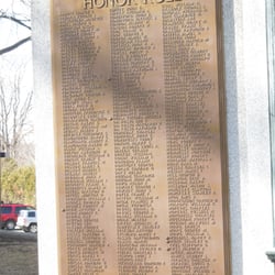
Courage Sacrifice Honor Determination 1959 1975 (Monument inscription) While looking for some background material on this monument, I found an excellent NY Times article from 1985, the year this monument was dedicated.. The small town of Wallingford sent 676 men and women to Vietnam. Twelve soldiers died there. Some of Wallingford's returning veterans wanted to build a Vietnam Memorial to honor the service of their colleagues. There was opposition from some folks of an "older generation of veterans" who didn't think the Vietnam vets deserved a monument. The article quoted a belief of some that "Losers don't deserve a monument". So the vets decided to pursue and fund the monument on their own. They raised $80,000 from T-shirt sales, car washes, garage sales, dinners and raffles. Local artists donated their services to help the monument become a reality. The design is striking- an eleven foot tall tilted V-shaped wedge of black granite. The artist who designed the monument said that the tilted angle represents "an inconclusive end to an undeclared war". The sides of the Wedge bear the names of hundreds of Wallingford's Vietnam vets. Some of the names are shadowed in a gold leaf to represent those Killed in Action. The V-shaped inscription reads: During the 16 years the war continued American Soldiers Sailors, Airmen and Marines fought with heroism and determination under some of the most difficult circumstances ever encountered by American armed forces. Tragically, upon their return home they received virtually no recognition for their service and sacrifice because of the raging controversy over United States policy in conducting the war. 300,000 were wounded in action 75,000 were permanently disabled 58,118 were killed in combat Later, thousands more would die as a result of gunshot wounds and the dioxin code named "agent orange" As of this date, November 11th, 1985, ten years after the fall of the Saigon government and twelve years after the removal of American ground forces from Vietnam, 2,489 brave Americans remain missing in action or held prisoners of war. They Are Not Forgotten read more


More info about Wallingford Vietnam Veterans Monument
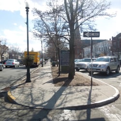
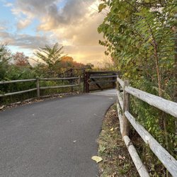
1151 E Center St
Wallingford, CT 06492
Directions
Hours
Outdoor Amenities


Wallingford Vietnam Veterans Monument - landmarks - Updated July 2026
Best of Wallingford
People found Wallingford Vietnam Veterans Monument by searching for…
Walking Trails in Wallingford, Connecticut
Places to Take Pictures in Wallingford, Connecticut
Fishing Spots in Wallingford, Connecticut
Free Things to Do in Wallingford, Connecticut
Scenic View in Wallingford, Connecticut
Date Ideas in Wallingford, Connecticut
Picnic Areas in Wallingford, Connecticut
Running Trails in Wallingford, Connecticut
Public Services & Government in Wallingford, Connecticut
Photo Spots in Wallingford, Connecticut
Picnic Spots in Wallingford, Connecticut
Things to Do at Night in Wallingford, Connecticut
State Park in Wallingford, Connecticut
Running Tracks Open to the Public in Wallingford, Connecticut
Meeting Places in Wallingford, Connecticut
Attractions in Wallingford, Connecticut
Playgrounds in Wallingford, Connecticut
Jail in Wallingford, Connecticut
Field Trips in Wallingford, Connecticut
View Points in Wallingford, Connecticut
Tourist Attractions in Wallingford, Connecticut
Chapel in Wallingford, Connecticut
Browse Nearby
BEST of Wallingford, Connecticut Restaurants near Wallingford Vietnam Veterans Monument
BEST of Wallingford, Connecticut Coffee near Wallingford Vietnam Veterans Monument
BEST of Wallingford, Connecticut Things to Do near Wallingford Vietnam Veterans Monument
BEST of Wallingford, Connecticut Breakfast near Wallingford Vietnam Veterans Monument
BEST of Wallingford, Connecticut Photo Spots near Wallingford Vietnam Veterans Monument
BEST of Wallingford, Connecticut Scenic Drive near Wallingford Vietnam Veterans Monument
BEST of Wallingford, Connecticut Hotels near Wallingford Vietnam Veterans Monument
BEST of Wallingford, Connecticut Campgrounds near Wallingford Vietnam Veterans Monument
BEST of Wallingford, Connecticut Day Trips near Wallingford Vietnam Veterans Monument
Browse Brands
Browse Articles
People who viewed Wallingford Vietnam Veterans Monument also viewed
Middletown Civil War Monument
1 review
West Haven World War I Monument
1 review
Kensington Volunteer Fire Department 9/11 Memorial
1 review
Waterbury Civil War Monument
1 review
Wallingford World War I Monument
1 review
Meriden's Traffic Tower
1 review
Portland Brownstone Arch
1 review
Amistad Memorial
3 reviews
Nathan Hale School House
1 review
Cromwell World War One Memorial
2 reviews