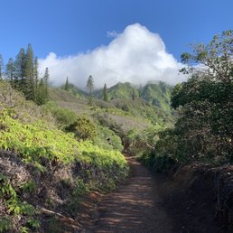
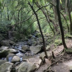
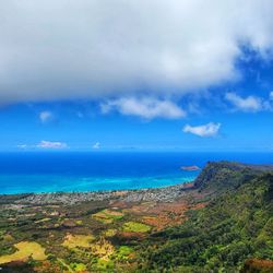
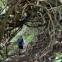
Wiliwilinui Ridge Trail Photos


You might also consider
More like Wiliwilinui Ridge Trail
Recommended Reviews - Wiliwilinui Ridge Trail
Start your review...

Reviews With Photos

This is probably the most challenging hike I've done so far. According to my Iphone the duration was 6 miles for total trip and 110 floors in height. Can I get a medal for this? Yes, it is a ridge hike with muddy in certain areas and lots of climbing up the stairs using ropes. I saw that some of the regular hikers wore shoes with spikes. I just wore my regular walking shoes and it was enough. But I highly recommend coming here on a sunny clear day only because it was muddy in certain spots and I can't imagine hiking here on a rainy day unless you're experienced hiker. When we got to the top, it was cloudy because you're so high up. It's not the rain cloud though. Once the cloud disappeared, you can see the entire windward side. The view was incredible! You have to see it for yourself. My photo won't express the view. You can also see the diamond head view but very small. I normally don't snack during any of my hikes but I do recommend bringing a small snack and eating them before heading down. My energy was down to zero while I was walking back down and it seem like forever. Bring lots of water too. I drink 2 bottled water. There's no public restroom. You have to go through a guard shack like other Yelpers mentioned. Go early. We got there around 6:45am and finished little after 10am. I am an average person so if I can do it then so can you.

The trailhead is located in a gated community. Thankfully when you stop off at the gate, security will provide you with a day pass. This hike can be a big muddy mess. The closer you get to the end it can get steep and the stairs that have been installed seem to be eroding so be careful. When I got up to the top the fog was quite thick. As it started to clear the view was quite spectacular. A good hike all in all but I definitely prefer kuli'ou'ou if given the choice between the two.

Gorgeous hike, but if you've only got time for one hike of this sort on the island, I'd recommend the Kuli'ou'ou Ridge Trail instead for better views at the top, and a more varied and interesting hike all the way up. Check out AllTrails for current conditions. Hike is not challenging for an experienced hiker, but may present some struggles if you're older, not very active, hopping on one leg etc. There's a few sections where you have to rely on a rope quite a bit. At one section, my weight was 100% on the rope as I climbed with my legs, and if the rope failed at that point I would have suffered a pretty nasty, though not debilitating, fall down the trail (but not at risk of going over the edge or anything). Going down can suck, and I scooted on my sizeable ass for some of the way, which helped a lot. Views at the top facing south were spectacular. The north was completely covered in fog. If you've got time for a few good hikes on Oahu, this should definitely be one of them and you won't be disappointed.

My hubby and I had such a blast hiking this trail, even if it dumped rain on us...twice! We got there early to make sure that we got a parking pass and parked right at the trailhead. It started to drizzle at the beginning of the trail which was covered by trees and relatively flat. There was one area early on with a rope to help get up the muddy trail. Later during the hike, the trail became more steep with sections of some steps as well. But the sun at come out so it was pretty easy to ascend even without using the ropes. The view at the top was absolutely beautiful and there was a bench at the top to enjoy the view as well. After a little while, the rain started to dump again which made the hike down pretty challenging as it was super muddy and slippery. We definitely utilized the ropes and still slipped in a couple places but had SO MUCH FUN as it was very exhilarating. We made it down safely and wished that we had brought extra shoes and clothes to change into. We look forward to hiking this trail again but plan to look ahead at the weather first!

Hiked: Saturday, 23rd April 2022. Weather: overcast with slight drizzling and windy. The trail is hidden at the back of a very rich-looking neighborhood (i.e. massive houses with beautiful landscaping and amazing views). There is a gate guard where hikers must stop and get a free parking pass. The gate guard stated that the trail is managed by the state and anyone parked in the area without a pass will get towed (We returned the parking pass to a Dropbox on our way out). Parking near the trailhead is limited to 8 slots in one designated area then, about 10-15 dirt slots, plus one designated handicap parking, nearer the entrance. The trailhead is well marked. The first 1/4 to 1/2 mile of the trail is paved or gravel so it is fairly easy to identify. Further along, it starts getting to be compact dirt with some areas getting loose and muddy. One area with a slight incline had a rope to assist hikers. We did not need it but I suspect if it gets too wet and slippery, it would be necessary. Some parts of the trail is narrow and you can see drop-offs into the valley. This is also were some of the more scenic views overlooked to coast or city in a distant. About halfway, there are stairs that replace the dirt trail. At yhis point, there are signs encouraging hikers to brush their boots to remove weed seeds. However, the one boot brush in place was filled with mud and worn out. Thus, it was ineffective. I hope it is replaced and others put in soon; (does anyone know how to pursue getting that done?). The steps only had risers, where the thread should be, it was just the ground. Because of this, it was basically compacted dirt, which was now muddy or filled with water. This is also where we stopped, enjoyed the view then turned around. Because it was very cloudy/overcase/drizzeling, my mother (64 yr old) didn't feel comfortable proceeding so we turned around and headed back (At that point we were also about 1.5 miles in so it wasn't a complete waste). We saw other hikers who proceeded without issues. So hopefully others aren't deterred. Overall, the part that i did experience was a great hike with spectacular views.

If you are looking for moderate-intermediate type of hike, this one is for you. you can have some stairmaster vibes but really good workout while trying to navigate thru the muddy hills and puddles. I went for my first time with my friend who servicing in Navy who from HI, has done this hike a few times, having his experience helped me feel reassured throughout the entire hike going up and going down. As I hiked thru the difficult muddy hills, I even sort of cried even wanted to call it quits, just hesitated on some of the sketchy muddy inclines with little rope to hang on. But my friend kept encouraging, was pretty impressed we got up within 1 hr. i'm so glad I got hiking gloves to hold onto the rope sections, came in handy. My friend and I also found a 4 year old hiking with his mom and aunt go to the top and back. If a 4 year old child can do it, you can conquer this hike. I would say come on a not rainy day, it will make it more difficult for the incline especially the muddy hills. Be careful going on steps, full of rain water, slippery. Once we made it to the end of the trail, it was so worth it and the views of windward and both East Honolulu were clear, just kept taking a bunch of photos until the rain comes down again. Also recommend you come early so you can get parking and it won't be super humid. There is parking lot when you reach past the guard tower, but if there is no stalls, there is also several stalls next to start of the trail. Take on the challenge and be my guest.

Amazing trail. One of your favorites because it's less crowded than diamond head and koko head. View is also way better!! Took us 2.5 hours total to complete the hike (1 hour and 15 minutes to get to the top). The hike is in a private property area, so the gates open at sunrise (around 6:30 am). There are limited parking spots up there so make sure to come early. Otherwise, you'll have to park outside the gate and walk an extra mile before getting to the start of the hike. 139 floors - according to my phone! 14,000+ steps! Definitely a lot of incline and steps. Moderate to strenuous hike! We started at 6:40 am and finished by 9:15 am! My family and I are pretty good hikers - so didn't take many breaks!

The trailhead for the Wiliwilinui Ridge, a 5.3 mi moderate hike with 1600 feet of gain, is located in a ritzy gated neighborhood community, so there are only 20 passes available corresponding to the designated parking stalls inside. You'll need to check in with a guard at the gate where they will provide you with the pass. I took a chance on a rainy morning, a bit torn on whether I should attempt a hike in such conditions. Hawaii is always rainy though, so the trails will ALWAYS be muddy. My main concern for a rainy hike was the potential for a fogged out viewpoint at the top. In a downpour, I checked in with the guard, secured a pass, and waited it out after parking. I then headed out equipped with trail runners, pack, my rain coat, and micro spikes (very helpful in mud). This is a fairly developed trail I'd say being mostly wide; one could avoid any muddy puddles with relative ease. There are some steep, slidey sections where ropes are present, installed probably by some passerby but they felt relatively safe and secure. In my opinion, the ascent was fairly gradual until mid-way where some stairs appeared. The set of stairways do end at a viewpoint where I was indeed fogged out! Despite the fog and rain though, the views of Waikiki through the sheets of pewter-opulent clouds were magnificent. I did not receive the all encompassing view of the island so that was a bummer! However, I appreciated the cardio invigoration for somehow I knew I'd have a fogged out view so what better way to make up for it by embarking on a fast, heart pounding ascent!

BEAUTIFUL UNREAL VIEWS! One of the best hikes I've been on - a must in Oahu. We did this hike October 2021. We started at 2:30pm which I don't recommended because it was pitch black by the time we got back to the car. We were the only ones doing the hike then so it was awesome just to be in nature alone. The intensity of the hike wasn't too bad. It's just difficult at the end where there are steep stairs. Slightly dangerous so definitely take your time to make sure you don't slip in the mud. Parking - we were able to get one of the coveted parking passes at the gate since nobody else was doing the hike at this time but I cannot imagine having to park by the entrance and walking up... it wouldn't be worth it imo.
Spectacular views as you move up to the second half of the ridge. Went here on a mostly sunny with a slight cloud weather and it's the most optimum environment for a ridge hike. The first half consist mostly uphill and some gravel to help with traction. The second half as you come along the stairs is where the challenge starts. I really underestimated how much stairs there was even though I've watched YouTube videos of people going to this trail. There's a couple sketchy climbs that I knew to make sure I take my time with. Better safe than sorry. As you get to the tower the clouds started to creep up and you can see views of the ridge you just traversed from. The final ridge was covered in fog and it felt like an accomplishment worthy before the New Years. Make sure to bring trail/hiking shoes. I've seen a couple hikers wearing running shoes and they had a challenge moving up these sketchy stairs and loose dirt. Also I used a hiking stick to help me move up the stairs as well as lessen the impact on knees when coming down the ridge. Bring a snack and at least a liter of water, it can get hot halfway through. And just in case, bring crampons if the path is muddy after a rain. In this case I didn't have to use it. I had to park before the guard as they had run out of parking permit, but I did see some stopped and waited. This was around 9am. The walk from the guard post to the start of the trail is a mile. It took me about 20-25 minutes to get to the trail from there. Looking back, I don't recommend it as the walk up is mostly uphill with some very steep. This adds an additional 2 miles in your hike to and back. I will wait next time.

This was a great trail! The trail starts at the end of the road. There's limited parking though, so if you dont get there early, you may not get a space, in which case you have to park before the gate and walk through a neighborhood...uphill...for 3/4 mile...to get to the trailhead. The trail is well marked and the first half is pretty wide. Then you hit the stairs and you go up up up. There's some mud, but it wasnt too bad. Only a few ropes, as you dont really need them. Near the end, there's a radio antenna or something. The final viewpoint on the Koolau ridge overlooking the windward side is just a few hundred feet later. From there, you can practically get a 360 degree view. Of course, the view of the windward side is fantastic! I'd definitely recommend going if you are looking to do a ridge hike. Tip: If you arent inclined to get out there super early to get a space, try arriving around 10AM. By then, some of the people who did get there super early will have left, hopefully freeing up a space for you. Worked for me, at least.

I have hiked this trail since 2016 and I always come back at least once a year since then. I've recently hiked this in Feb 2022 and the trail is still one of my favorites. In order to get to the trail, you will have to pass a security check point where they only give 20 passes for parking at the start of the trail. So if you get there when all passes are given out you won't be able to pass the guard. You are still able to hike the trail, but you will have to park on the street and walk about a half mile up to the start of the trail (I don't recommend this as it tired me out). They start giving passes out at the start of sunrise. This is a well maintained trail and beautiful views about 10 mins into the trail. The trail can get muddy after a very heavy rainfall, so try going on a day where it has been dry and sunny for about a week. On muddy/rainy days it makes the trail a lot more slippery and dangerous, especially on the ridge part of the trail. The first half of the trail is mostly covered so you get most of the shade you can. You'll get views of the valley as well as the town and diamond head at this point. Once you reach the halfway point, you'll be hiking the ridge at this point (you'll know when you see the stairs). At this point be careful of your footing as well as loose dirt/rocks, and damaged stairs. Although our first half of the hike was dry, the higher we got on the ridge, it started to rain. Again the rain makes the terrain a bit more difficult causing rocks and the stairs more slippery, so be very careful. Since you're going up higher in altitude it's also a lot more breezy and the grounds a lot more moist. It is a bit of a workout going up since it's all incline at this point. Please be aware of other hikers as well, let others pass as the trail does get narrow. At some points of the ridge when you look back, you get the whole view of Waikiki and Diamond Head, as well as the ocean. I took about an hour to get to the top. You'll know you reach the top when you reach the structure that's on the ridge. Once you reach the structure, if you continue past, you'll get to the view point that will greet you with astounding views of the East Side of Oahu. You'll be able to see Lanikai from here. Sadly I didn't get views this day as it was cloudy at the top. Tips: - 2-3 Hour round trip (1 hour up) remember it differs for everyone -Bring enough water -Be careful, wear good footwear (with good grip) -Be aware of your surroundings -Hiking on a sunny day? Bring sunscreen -Carry a snack or energy bar -A crazy selfie is not worth any risk

A fun adventurous trail with one of the best views of the island, there is good reason this is considered one of the best hikes on Oahu, but be warned, it is called nature's stairmaster for a good reason. The hike is located in a gated community so you will need to ask the guard for a parking pass, but didn't have any issues with that [and you can ensure that your car is pretty safe which is not the case with most trails]. I went after a pretty dry week on an afternoon and the trail was in phenomenal conditions with very little mud. The trail builds up slowly, preparing you for that final climb at the end with the stairs and ropes, but to be honest, didn't really need the ropes until going down. The views are absolutely incredible and the hike itself is very peaceful, with the sound of the birds and the wind really taking you out of the city. As always, bring plenty of water, sunscreen, and endurance to get through that final blast of stairs.

i'm ngl, this hike rocked my world. i did NOT know what i was signing myself up for, but i'm so happy i got to experience this!! perfect way to spend our morning! i was genuinely in disbelief at how stunning this trail was. it felt moderately lengthy, so it was a whole EXPERIENCE. the beginning was a breeze (shaded, not too steep), but omg towards the end it got challenging real fast :') i didn't see a single person leave with clean shoes... absolutely WORTH IT THO. probs wouldn't recommend after the rain bc the mud gets super slippery. it was really cool being so high up hehe i had lots of fun! read more


This trail has some of the beautiful views. It can be challenging at times, with big climbs and steep sections. Just take your time it is worth the climb. Limited parking, so you may a have a wait until someone else turns in the trail parking pass. I will do this hike again!! read more


9 months ago
An epic experience and what a hike! I'm 47 years old and not too much out of shape but still managed to get to the top in good time. The view of the east side was breathtaking. I will certainly hike this trail again. read more


10 months ago
This is probably the most challenging hike I've done so far. According to my Iphone the duration was 6 miles for total trip and 110 floors in height. Can I get a medal for this? Yes, it is a ridge hike with muddy in certain areas and lots of climbing up the stairs using ropes. I saw that some of the regular hikers wore shoes with spikes. I just wore my regular walking shoes and it was enough. But I highly recommend coming here on a sunny clear day only because it was muddy in certain spots and I can't imagine hiking here on a rainy day unless you're experienced hiker. When we got to the top, it was cloudy because you're so high up. It's not the rain cloud though. Once the cloud disappeared, you can see the entire windward side. The view was incredible! You have to see it for yourself. My photo won't express the view. You can also see the diamond head view but very small. I normally don't snack during any of my hikes but I do recommend bringing a small snack and eating them before heading down. My energy was down to zero while I was walking back down and it seem like forever. Bring lots of water too. I drink 2 bottled water. There's no public restroom. You have to go through a guard shack like other Yelpers mentioned. Go early. We got there around 6:45am and finished little after 10am. I am an average person so if I can do it then so can you. read more


3 years ago
The trailhead is located in a gated community. Thankfully when you stop off at the gate, security will provide you with a day pass. This hike can be a big muddy mess. The closer you get to the end it can get steep and the stairs that have been installed seem to be eroding so be careful. When I got up to the top the fog was quite thick. As it started to clear the view was quite spectacular. A good hike all in all but I definitely prefer kuli'ou'ou if given the choice between the two. read more


Gorgeous hike, but if you've only got time for one hike of this sort on the island, I'd recommend the Kuli'ou'ou Ridge Trail instead for better views at the top, and a more varied and interesting hike all the way up. Check out AllTrails for current conditions. Hike is not challenging for an experienced hiker, but may present some struggles if you're older, not very active, hopping on one leg etc. There's a few sections where you have to rely on a rope quite a bit. At one section, my weight was 100% on the rope as I climbed with my legs, and if the rope failed at that point I would have suffered a pretty nasty, though not debilitating, fall down the trail (but not at risk of going over the edge or anything). Going down can suck, and I scooted on my sizeable ass for some of the way, which helped a lot. Views at the top facing south were spectacular. The north was completely covered in fog. If you've got time for a few good hikes on Oahu, this should definitely be one of them and you won't be disappointed. read more


4 years ago
My hubby and I had such a blast hiking this trail, even if it dumped rain on us...twice! We got there early to make sure that we got a parking pass and parked right at the trailhead. It started to drizzle at the beginning of the trail which was covered by trees and relatively flat. There was one area early on with a rope to help get up the muddy trail. Later during the hike, the trail became more steep with sections of some steps as well. But the sun at come out so it was pretty easy to ascend even without using the ropes. The view at the top was absolutely beautiful and there was a bench at the top to enjoy the view as well. After a little while, the rain started to dump again which made the hike down pretty challenging as it was super muddy and slippery. We definitely utilized the ropes and still slipped in a couple places but had SO MUCH FUN as it was very exhilarating. We made it down safely and wished that we had brought extra shoes and clothes to change into. We look forward to hiking this trail again but plan to look ahead at the weather first! read more


4 years ago
Hiked: Saturday, 23rd April 2022. Weather: overcast with slight drizzling and windy. The trail is hidden at the back of a very rich-looking neighborhood (i.e. massive houses with beautiful landscaping and amazing views). There is a gate guard where hikers must stop and get a free parking pass. The gate guard stated that the trail is managed by the state and anyone parked in the area without a pass will get towed (We returned the parking pass to a Dropbox on our way out). Parking near the trailhead is limited to 8 slots in one designated area then, about 10-15 dirt slots, plus one designated handicap parking, nearer the entrance. The trailhead is well marked. The first 1/4 to 1/2 mile of the trail is paved or gravel so it is fairly easy to identify. Further along, it starts getting to be compact dirt with some areas getting loose and muddy. One area with a slight incline had a rope to assist hikers. We did not need it but I suspect if it gets too wet and slippery, it would be necessary. Some parts of the trail is narrow and you can see drop-offs into the valley. This is also were some of the more scenic views overlooked to coast or city in a distant. About halfway, there are stairs that replace the dirt trail. At yhis point, there are signs encouraging hikers to brush their boots to remove weed seeds. However, the one boot brush in place was filled with mud and worn out. Thus, it was ineffective. I hope it is replaced and others put in soon; (does anyone know how to pursue getting that done?). The steps only had risers, where the thread should be, it was just the ground. Because of this, it was basically compacted dirt, which was now muddy or filled with water. This is also where we stopped, enjoyed the view then turned around. Because it was very cloudy/overcase/drizzeling, my mother (64 yr old) didn't feel comfortable proceeding so we turned around and headed back (At that point we were also about 1.5 miles in so it wasn't a complete waste). We saw other hikers who proceeded without issues. So hopefully others aren't deterred. Overall, the part that i did experience was a great hike with spectacular views. read more


If you are looking for moderate-intermediate type of hike, this one is for you. you can have some stairmaster vibes but really good workout while trying to navigate thru the muddy hills and puddles. I went for my first time with my friend who servicing in Navy who from HI, has done this hike a few times, having his experience helped me feel reassured throughout the entire hike going up and going down. As I hiked thru the difficult muddy hills, I even sort of cried even wanted to call it quits, just hesitated on some of the sketchy muddy inclines with little rope to hang on. But my friend kept encouraging, was pretty impressed we got up within 1 hr. i'm so glad I got hiking gloves to hold onto the rope sections, came in handy. My friend and I also found a 4 year old hiking with his mom and aunt go to the top and back. If a 4 year old child can do it, you can conquer this hike. I would say come on a not rainy day, it will make it more difficult for the incline especially the muddy hills. Be careful going on steps, full of rain water, slippery. Once we made it to the end of the trail, it was so worth it and the views of windward and both East Honolulu were clear, just kept taking a bunch of photos until the rain comes down again. Also recommend you come early so you can get parking and it won't be super humid. There is parking lot when you reach past the guard tower, but if there is no stalls, there is also several stalls next to start of the trail. Take on the challenge and be my guest. read more


3 years ago
Amazing trail. One of your favorites because it's less crowded than diamond head and koko head. View is also way better!! Took us 2.5 hours total to complete the hike (1 hour and 15 minutes to get to the top). The hike is in a private property area, so the gates open at sunrise (around 6:30 am). There are limited parking spots up there so make sure to come early. Otherwise, you'll have to park outside the gate and walk an extra mile before getting to the start of the hike. 139 floors - according to my phone! 14,000+ steps! Definitely a lot of incline and steps. Moderate to strenuous hike! We started at 6:40 am and finished by 9:15 am! My family and I are pretty good hikers - so didn't take many breaks! read more


5 years ago
The trailhead for the Wiliwilinui Ridge, a 5.3 mi moderate hike with 1600 feet of gain, is located in a ritzy gated neighborhood community, so there are only 20 passes available corresponding to the designated parking stalls inside. You'll need to check in with a guard at the gate where they will provide you with the pass. I took a chance on a rainy morning, a bit torn on whether I should attempt a hike in such conditions. Hawaii is always rainy though, so the trails will ALWAYS be muddy. My main concern for a rainy hike was the potential for a fogged out viewpoint at the top. In a downpour, I checked in with the guard, secured a pass, and waited it out after parking. I then headed out equipped with trail runners, pack, my rain coat, and micro spikes (very helpful in mud). This is a fairly developed trail I'd say being mostly wide; one could avoid any muddy puddles with relative ease. There are some steep, slidey sections where ropes are present, installed probably by some passerby but they felt relatively safe and secure. In my opinion, the ascent was fairly gradual until mid-way where some stairs appeared. The set of stairways do end at a viewpoint where I was indeed fogged out! Despite the fog and rain though, the views of Waikiki through the sheets of pewter-opulent clouds were magnificent. I did not receive the all encompassing view of the island so that was a bummer! However, I appreciated the cardio invigoration for somehow I knew I'd have a fogged out view so what better way to make up for it by embarking on a fast, heart pounding ascent! read more


5 years ago
BEAUTIFUL UNREAL VIEWS! One of the best hikes I've been on - a must in Oahu. We did this hike October 2021. We started at 2:30pm which I don't recommended because it was pitch black by the time we got back to the car. We were the only ones doing the hike then so it was awesome just to be in nature alone. The intensity of the hike wasn't too bad. It's just difficult at the end where there are steep stairs. Slightly dangerous so definitely take your time to make sure you don't slip in the mud. Parking - we were able to get one of the coveted parking passes at the gate since nobody else was doing the hike at this time but I cannot imagine having to park by the entrance and walking up... it wouldn't be worth it imo. read more


Spectacular views as you move up to the second half of the ridge. Went here on a mostly sunny with a slight cloud weather and it's the most optimum environment for a ridge hike. The first half consist mostly uphill and some gravel to help with traction. The second half as you come along the stairs is where the challenge starts. I really underestimated how much stairs there was even though I've watched YouTube videos of people going to this trail. There's a couple sketchy climbs that I knew to make sure I take my time with. Better safe than sorry. As you get to the tower the clouds started to creep up and you can see views of the ridge you just traversed from. The final ridge was covered in fog and it felt like an accomplishment worthy before the New Years. Make sure to bring trail/hiking shoes. I've seen a couple hikers wearing running shoes and they had a challenge moving up these sketchy stairs and loose dirt. Also I used a hiking stick to help me move up the stairs as well as lessen the impact on knees when coming down the ridge. Bring a snack and at least a liter of water, it can get hot halfway through. And just in case, bring crampons if the path is muddy after a rain. In this case I didn't have to use it. I had to park before the guard as they had run out of parking permit, but I did see some stopped and waited. This was around 9am. The walk from the guard post to the start of the trail is a mile. It took me about 20-25 minutes to get to the trail from there. Looking back, I don't recommend it as the walk up is mostly uphill with some very steep. This adds an additional 2 miles in your hike to and back. I will wait next time. read more


This was a great trail! The trail starts at the end of the road. There's limited parking though, so if you dont get there early, you may not get a space, in which case you have to park before the gate and walk through a neighborhood...uphill...for 3/4 mile...to get to the trailhead. The trail is well marked and the first half is pretty wide. Then you hit the stairs and you go up up up. There's some mud, but it wasnt too bad. Only a few ropes, as you dont really need them. Near the end, there's a radio antenna or something. The final viewpoint on the Koolau ridge overlooking the windward side is just a few hundred feet later. From there, you can practically get a 360 degree view. Of course, the view of the windward side is fantastic! I'd definitely recommend going if you are looking to do a ridge hike. Tip: If you arent inclined to get out there super early to get a space, try arriving around 10AM. By then, some of the people who did get there super early will have left, hopefully freeing up a space for you. Worked for me, at least. read more


I have hiked this trail since 2016 and I always come back at least once a year since then. I've recently hiked this in Feb 2022 and the trail is still one of my favorites. In order to get to the trail, you will have to pass a security check point where they only give 20 passes for parking at the start of the trail. So if you get there when all passes are given out you won't be able to pass the guard. You are still able to hike the trail, but you will have to park on the street and walk about a half mile up to the start of the trail (I don't recommend this as it tired me out). They start giving passes out at the start of sunrise. This is a well maintained trail and beautiful views about 10 mins into the trail. The trail can get muddy after a very heavy rainfall, so try going on a day where it has been dry and sunny for about a week. On muddy/rainy days it makes the trail a lot more slippery and dangerous, especially on the ridge part of the trail. The first half of the trail is mostly covered so you get most of the shade you can. You'll get views of the valley as well as the town and diamond head at this point. Once you reach the halfway point, you'll be hiking the ridge at this point (you'll know when you see the stairs). At this point be careful of your footing as well as loose dirt/rocks, and damaged stairs. Although our first half of the hike was dry, the higher we got on the ridge, it started to rain. Again the rain makes the terrain a bit more difficult causing rocks and the stairs more slippery, so be very careful. Since you're going up higher in altitude it's also a lot more breezy and the grounds a lot more moist. It is a bit of a workout going up since it's all incline at this point. Please be aware of other hikers as well, let others pass as the trail does get narrow. At some points of the ridge when you look back, you get the whole view of Waikiki and Diamond Head, as well as the ocean. I took about an hour to get to the top. You'll know you reach the top when you reach the structure that's on the ridge. Once you reach the structure, if you continue past, you'll get to the view point that will greet you with astounding views of the East Side of Oahu. You'll be able to see Lanikai from here. Sadly I didn't get views this day as it was cloudy at the top. Tips: - 2-3 Hour round trip (1 hour up) remember it differs for everyone -Bring enough water -Be careful, wear good footwear (with good grip) -Be aware of your surroundings -Hiking on a sunny day? Bring sunscreen -Carry a snack or energy bar -A crazy selfie is not worth any risk read more


5 years ago
A fun adventurous trail with one of the best views of the island, there is good reason this is considered one of the best hikes on Oahu, but be warned, it is called nature's stairmaster for a good reason. The hike is located in a gated community so you will need to ask the guard for a parking pass, but didn't have any issues with that [and you can ensure that your car is pretty safe which is not the case with most trails]. I went after a pretty dry week on an afternoon and the trail was in phenomenal conditions with very little mud. The trail builds up slowly, preparing you for that final climb at the end with the stairs and ropes, but to be honest, didn't really need the ropes until going down. The views are absolutely incredible and the hike itself is very peaceful, with the sound of the birds and the wind really taking you out of the city. As always, bring plenty of water, sunscreen, and endurance to get through that final blast of stairs. read more


7 years ago
This is a great trail that takes you to the top of one of the higher peaks in Honolulu. It's pretty strenuous near the end as there are a lot of stairs. If it's muddy, it'll be even harder. Thankfully, they've put some ropes to help you ascend/descend on some parts. First off, the directions via this app will lead you nowhere near the entrance for some reason. You have to drive all the way to the top of this hilly, multi-million dollar community until you reach a gated security area, which leads you into an area with even more expensive homes. You'll get a pass and then drive even further up the road until you hit the trail head. There's minimal parking so I suggest you go early morning. The first mile and a half or so (I never really counted) is fire road. Then you hit some mostly uphill tracks. Very doable stuff with plenty of cover. When you reach the point where you can actually see the summit, that's where it gets difficult. Lots of stairs with a steep incline. Be careful when ascending and descending (especially when muddy). After all, it is a ridge. Just take your time; no need to rush, folks. If you're afraid of heights, this might not be for you. Or you can try it, just don't look down. At the end, you'll be rewarded with stunning vistas of the southeastern part of the island. Very breathtaking. Depending on your level of hiking, I would say this is a very doable hike, probably moderate to intermediate. Just make sure you bring lots of water and shoes with traction. It's well worth it. read more


5 years ago
ONE OF OAHU'S BEST HIKES! A medium difficulty hike but one of the most fun and beautiful hikes i've done in my trip to Oahu! The Wiliwilinui Ridge Trail is definitely on the medium-difficulty side, with that being said, I am fairly new to hiking and this did leave me tired but not to the point where it felt bad! The hike starts off with gradual incline and then leads into some incline with large stairs. The stair part can get very tiring, so just take your time and move at your own pace! It can get a little scary as you're on a narrow path once you reach the top and the view around you is the cliff, but it is very beautiful and you can see all of the greenery and ocean around you! Once you get to the top, the view is amazing. I believe you can continue on, but we decided not to since it started to sprinkle a little and the sun was setting! TIPS: 1. Make sure to go when it has not rained heavily the day before. It was quite muddy during some portions of the hike, it didn't make it anymore difficult it was just annoying to step in mud and you could slip on the stair if your shoes are wet with mud. 2. This hike took around 3 hours from start to end, be sure to plan accordingly and not hike too late otherwise you will need a flashlight or phone light to see! 3. You have to pass by a residential area to get to the start of the trail, just keep that in mind in case you are confused. 4. Parking can be very limited, luckily we went around 3PM and there was still parking available. read more


One of the tougher trails I've done in Hawaii, and definitely the most hazardous I've done solo. I would highly recommend wearing real hiking shoes for the last part as it is muddy and requires some climbing. The first half is fairly easy to moderate and can be done in sandals or sneakers and still affords you pretty good views. Also recommend wearing longer pants because the plants can be pretty overgrown in some parts. Once you start getting to the electrical towers though, all bets are off. You know this trail was slick because it took me almost as long to come down as it did to go up (1.5 hours each way, 3 hours total, out and back) because of how treacherous footing was. I took things fairly slow since I was hiking solo and trying to be more careful of my footing. There are ropes to help you in some places (mostly at the last third), and some of them were very necessary because of how many of the old steps were washed out. I had to steel myself and use some bravery points near the end with washed out steps and basically climbing up a questionable muddy staircase. The last electrical tower still afforded some nice views, but the mist and cloud cover came in and made the end of the trail look like an endless void. Will have to do this one again on a bright day or early morning to get the best view, although I enjoyed the reprieve from the sun as there is little shade on most of this hike. Parking was fairly easy on a Friday afternoon, although maybe I lucked out because it was a weekday and clouds looked questionable. You'll have to show your ID to the gate guard and display the pass on your dash. Also, this is yet another hike where I saw someone local trail running it. Insanity! Overall, great hike that starts off fairly easy/moderate that turns challenging towards the end with some great views. Check the weather to make sure it hasn't rained too recently, wear the right shoes (or only do the first half), and take it slow. read more


6 years ago
A few tips. This hike is marked as moderate on all trails. I would say its a little more than a moderate hike for beginners. Bring a good amount of water, and try to come early. They only allow 20 passes vehicles at a time. We arrived a little after 8am, and all the passes were gone. We had to park outside of Waialae Iki so that added about an extra mile both ways. I would suggest hiking this trail on a dry day, and verify that it hasn't rained 1-2 days before. With that being said, this hike was awesome. It's elevation gain is about 1600 ft so its a lot of steep incline. There are several ridges you must pass to the top, but the view makes it worth it. When you get to the top, the air gets a little thin. The views are amazing. You can see Hawaii Kai and Kailua. When I did this hike, I haven't hiked or exercised in a while, so it was tough. I felt accomplished at the end. read more


7 years ago
A fairly straight forward up and down hike, starts off shady with inclines and declines until you reach higher elevation you break out abound the tree lines and start to see the other ridges on your left and right. If it was raining the day before the beginning of the hike will be muddy so bring plastic bags and slippers for after the hike and water to wash your legs. We went on a day where it was going to storm and it showed once we made it to the steps leading up to the radio tower. No view at the top for us as we were in cloud-9 but was a great work out and good way to end our Sunday. Bring water for the hike and after to rinse off!!! When in doubt turn around, 4/19/2019 Came back to one of my go to hike on the island with more friends, the only difference between this and the last time was the weather was more clearer. As usual make sure you google search Laukahi st because for some reason putting in wiliwilinui hiking trail takings you over to the next valley deeper into Hawaii Kai. This hike is 4.5 miles long round trip so pack your gear accordingly that best suits you. Highly recommend going on a day that's has clear skies to full experience the views! read more


6 years ago
This hike was scary! It's really steep and muddy as well! Just to remind you this hike has a lot of muddy areas, no shade, a lot of bugs, really steep, really rocky, and is really LONG! If this is your first time hiking this trail then you better be ready for a long and challenging hike because this will make your cabs burn! When we hiked this trail it took us about 4/5 hours up and down this hike! Once we reached the top around 4:30pm it started to get cloudy. And it was harder to go down because of the clouds. It's harder to see where your going. So, if this is your first time it's best to go before 4:30pm come to the trail in the morning/ early afternoon to get the amazing view! It's not worth it going to the top and all you see is only clouds. You won't be able to see the view or take any pictures. So I recommend going REALLY early before it's late! One thing I hate about this hike is the stairs. The stairs aren't stable. Like there's a few of them that was gonna break off once you stepped on it! Like that's really dangerous! Other than that! Everything was great! It was a great and challenging workout for me and my friends:) read more


There are indeed a lot of short stairways here. Some of them are just metal bars. I hiked it dry but I can imagine this being a muddy, slippery pain in the rear if it were wet. That being said, the hike is a beautiful garden hike (photos posted), the most lush garden hike I did on Honolulu. And, the payoff at the summit is nice. It was the only summit where I saw simultaneous views of East (Kailua), West and South (Waikiki) beaches. read more


2 years ago
5 years ago
Disclaimer: I am not entirely a active fit person and only gone on hikes a few times in my life. But I heard about it and wanted to try it for myself with a few friends. I love that there was decent amount of shades from the trees and the clouds/ vog. And knowing how much I accomplished under my circumstances. If you love adventures, getting dirty, and trying out new things, I would recommend it! For a fair warning, I only recommend bringing your kids to this hike for half of the hike. It's decently paved but very steep incline. And BRING ALOT OF WATER & SOME SNACKS!!! I brought 3 liters of water and it wasn't enough for me. Also don't bring shoes that you love, it will get ruined if you the whole hike. Once you reach the half of the hike, there's going to be some stairs to get to the other half of the hike. It's going to be very difficult getting to the top of the trail; the stairs are very steep (almost eroded with mud), eventually becomes extremely muddy. And when you reached 75% of the hike, there's going to be a rope to climb. If you're short and no upper body strength, good luck because I wasn't able to climb it. When coming down, take your time because you will slip from the mud. Would recommend doing this early morning. It took us almost 4 hours to finish this hike. read more


This hike is amazing. Unfortunately, I went on a very cloudy, rainy day, so I did not see much of a view, but the hike itself was great! Not too challenging and not too easy. Just the right amount of a good longish hike. I felt like it took a while to get to the top. Driving through the neighborhood was nice too, the houses are so rich... If you have done Kuli'ouou it is similar with the length and I think way better! It doesn't have the long boring zig zag in the beginning like Kuli. The hike is pretty far up the hill/mountain? First, you must drive up the hill with all the nice houses and then hike up higher! This is a great hike for a great view! Definitely is a must! Make sure to wear good shoes with grips if ya don't want to be slipping and sliding around the whole time! Great place to take pictures, go with a group of friends or one friend! There is a parking area for cars as well! read more


If you're looking for a ridge hike that's not to extreme or long this hike is perfect! If you're not in shape once you hit the start of the stairs you will probably slow down, a lot, but the view was worth it! I would say this is like Koko head, but harder as the stairs twist and turn and break up in some parts, and there's an area you may need rope for assistance. The point you're looking to reach (and you will see it and the trail before you hit the stairs) is the electrical tower at the highest point on the ridge! Once there we were able to see all the way to KoKo Head/Portlock, and all the way to Campbell industrial and the slopes of Makakilo! Then when you turn around you will see Kaneohe, Mt Olomana right in from of you, Lanikai, and then Waiamanalo!!! Yes you will be way above the peaks of Olomana, pretty much standing on top of the Koolau Ridgeline that separates windward side from town. I really enjoyed this hike and it was definitely a work out! It took us a little longer, 3.5 hours. That's stopping for pictures, breaks, and taking our time going up. It took us less than an hour to get back to our car from the end of the trail. I recommend this hike on a clear day so you see all the views! read more


Really cool hike with incredible views at the top. Didn't realize how steep it was. The trail goes all the way to the top of mountain. Might be slippery during rainy conditions and better to get down before it gets dark. You do have to go through a gated community. read more

To get to Wiliwilinui, you drive up on Laukahi Street until you reach the guard shack. Give him your ID so he can issue you a parking pass. If there are no more parking stalls available then keep trying up and park on the dirt by the entrance to the hike. This hike is overall pretty easy, until you get closer to the top. If your like me and steepness is your enemy it gets a little challenging constantly being out of breath. But taking breaks always helps. It's worth it to make it all the way to the top because you can get a great panoramic view of the island. PRO TIP: Bring sunscreen! I wore sunscreen but didn't apply enough because I ended up getting a slight sunburn on my shoulders :( BOO. read more


6 years ago
Beautiful hike. Interval incline, often muddy making it slippery in spots. Bring enough water, snacks and some would benefit from hiking poles. 360° breathtaking view at the top. read more


7 years ago
This one is for the legs and cardio, that's for sure. To get here, you have to drive above Aina Haina, show your ID, get a parking pass, drive through a gated community, and park at the bottom of the hike. The first mile-1.5 mile is relatively flat (and shaded!!), but after that... HUNNAY. You'll d i e if your workouts don't usually have a cardio component and/or you're not wearing proper hiking boots. Thankfully, I do Pilates regularly and own hiking boots, but my friends were D Y I N G. Poor tings LOL (I mean, I was at some parts too. Gotta stay humble). The second half of the hike is pretty much a steep incline with sets of stairs. For the last 20 minutes of the hike, there are several ropes portions; really a testament to how steep it gets. Thankfully, there are great views to be found throughout the hike to motivate you to keep going! One side of the view at the top is from Chinaman's hat to Waimānalo. The other side is from the airport to Hawaii Kai. Pretty darn cool if you ask me. -1 star though bc the effort is harder for a similar view at Kuliouou, whose trailhead is 15-20 min more eastbound. This hike is a great workout and is still very much worth a trek though. read more


! - Hiking Near Me")


6 years ago
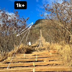
You don't need a Stairmaster if you hike this trail. The last third of it is straight up a lot of stairs....You did make a massage appointment for the next day right? Because your legs-quads and calves will need TLC. The photos don't show how vertical the climb is....the first set of stairs look deceptively easy. The cool thing about this trail is that you end up cutting across the middle of the island from East Oahu to seeing over to the Windward side. Hope the clouds don't block your view at the top! And remember, when you get to the electric structure at the top, you're not at the end...not yet. It's another 10 minutes or so till you reach the end. Going further pass the danger signs would mean you're literally walking on the top of the ridge! Passes are given out at the guard shack at the top of Waialae Iki. Go all the way up Laukahi Street off Kalanianiole Highway. You'll see the guard waiting to give out 20 coveted passes per day. The pass allows you to park at the start of the trail at the end of Okoa Street. No worries, it's easy to find and the pass has a map on the flip side. After the last pass is given out, you'll need to wait for someone to exit to get a pass. Limited access! Enjoy the awesome views that stretch all the way from Hawaii Kai to Diamond Head to downtown Honolulu and beyond on one side. And then the beautiful stretch of the Windward side at the top. Epic! read more


8 years ago
As you drive closer to the hike you have to drive through a residential area to the gate guard for a pass. As you travel for 2 miles up a hill of wealth to reach the hike you start to contemplate your career choices. No worries though, the sadness of poverty dissipates once you begin your adventure! It's absolutely beautiful. Be prepared for it to Rain off and on regardless of weather apps and bring a spare change of shoes to not cover your car in mud. Moderately shady but sunscreen and bug spray definitely recommended. Took us 3 hours to Complete with stops for hydration, urination, and selfies read more


I would say this is at the very least a moderate hike. It was a great workout. When you get to the top you are literally in the clouds. Great views of the island. The last part of the hike is mostly stairs. This was definitely one of my favorite hikes on the island. read more


8 years ago
One of the best trail n Oahu. It's a combination of stairs and low key rock climbing. Don't worry--no cliff. Not until you get to the top. Take note. Anyone can do this hike. However the trail will put your knees to the test. Especially to the part where you have to use rope. This "can" be a kid friendly hike. Still I wouldn't take small kids to this trail just to be SAFE. But I've seen people take their dogs. In my opinion, this hike will be more enjoyable for adults. Bring a good amount of water, most especially if your hiking midday. I normally go here in the morning and if We get lucky enough we're done before lunch. Also, bug spray will be helpful to avoid mosquitoes and fruit flies. Just a friendly reminder, please don't leave any trash up there. read more


Page 1 of 4
More info about Wiliwilinui Ridge Trail
Honolulu, HI 96821
Directions
Hours
Indoor Amenities
Outdoor Amenities
Wiliwilinui Ridge Trail Reviews in Other Languages
Ask the Community - Wiliwilinui Ridge Trail
In order to get a pass do you need to have a Hawaii license?
I don't think you need a Hawai'i license. I saw people from all over the world on this hike. Just bring a valid ID and see if that gets you in :)
Can you get in if you show up too early? Like 530 or 600?
You'll definitely be one of the first people with a pass! Just bring an ID.
Review Highlights - Wiliwilinui Ridge Trail
You might also consider


Why does Yelp recommend reviews?
4 reviews that are not currently recommended
The reviews below are not factored into the business's overall star rating.
9 years ago
9 years ago
15 years ago
11 years ago
Wiliwilinui Ridge Trail - hiking - Updated June 2026
Best of Honolulu
People found Wiliwilinui Ridge Trail by searching for…
Night View in Honolulu, Hawaii
Hiking Trails in Honolulu, Hawaii
Pokemon Go in Honolulu, Hawaii
Dog Friendly Beaches in Honolulu, Hawaii
Hiking Club in Honolulu, Hawaii
Things to Do in Honolulu, Hawaii
Abandoned Places in Honolulu, Hawaii
Scenic Views in Honolulu, Hawaii
Night Hike in Honolulu, Hawaii
Rope Swing in Honolulu, Hawaii
Natural Hot Springs in Honolulu, Hawaii
Waterfall Hike in Honolulu, Hawaii
Rock Climbing in Honolulu, Hawaii
View Points in Honolulu, Hawaii
Waterfalls in Honolulu, Hawaii
Dog Friendly Things to Do in Honolulu, Hawaii
Running Trails in Honolulu, Hawaii
Dog Friendly Hiking Trails in Honolulu, Hawaii
Walking Groups in Honolulu, Hawaii
Bamboo Forest in Honolulu, Hawaii
Trending Searches in Honolulu, HI
Beaches near Wiliwilinui Ridge Trail
Bird Sanctuary near Wiliwilinui Ridge Trail
Boat Rental near Wiliwilinui Ridge Trail
Cliff Jumping near Wiliwilinui Ridge Trail
Day Trips near Wiliwilinui Ridge Trail
Dog Friendly Trails near Wiliwilinui Ridge Trail
Fishing Spots near Wiliwilinui Ridge Trail
Free Kids Activities near Wiliwilinui Ridge Trail
Jet Ski Rental near Wiliwilinui Ridge Trail
Kayak Rental near Wiliwilinui Ridge Trail
Lakes & Ponds near Wiliwilinui Ridge Trail
Off Road Trails near Wiliwilinui Ridge Trail
Outdoor Activities near Wiliwilinui Ridge Trail
Pick Your Own Farms near Wiliwilinui Ridge Trail
Places To Walk Around near Wiliwilinui Ridge Trail
Public Shower near Wiliwilinui Ridge Trail
Rock Quarry near Wiliwilinui Ridge Trail
Scenic Drive near Wiliwilinui Ridge Trail
Secluded Spots near Wiliwilinui Ridge Trail
Soccer Store near Wiliwilinui Ridge Trail
Splash Pad near Wiliwilinui Ridge Trail
Strawberry Picking near Wiliwilinui Ridge Trail
Sunrise View near Wiliwilinui Ridge Trail
Swimming Holes near Wiliwilinui Ridge Trail
Swimming Lakes near Wiliwilinui Ridge Trail
Swimming Pools near Wiliwilinui Ridge Trail
Watch Sunset near Wiliwilinui Ridge Trail
Browse Articles
Browse Nearby
BEST of Honolulu, Hawaii Coffee near Wiliwilinui Ridge Trail
BEST of Honolulu, Hawaii Things to Do near Wiliwilinui Ridge Trail
BEST of Honolulu, Hawaii Restaurants near Wiliwilinui Ridge Trail
BEST of Honolulu, Hawaii Breakfast near Wiliwilinui Ridge Trail
BEST of Honolulu, Hawaii Parks near Wiliwilinui Ridge Trail
BEST of Honolulu, Hawaii Campgrounds near Wiliwilinui Ridge Trail
BEST of Honolulu, Hawaii Scenic View near Wiliwilinui Ridge Trail
BEST of Honolulu, Hawaii Cabins near Wiliwilinui Ridge Trail
Browse Brands
Related Searches in Honolulu, HI
Affordable Kayak Rental Services in Honolulu, Hawaii
Best Fishing Locations and Guides in Honolulu, Hawaii
Best Nature Trails for Hiking in Honolulu, Hawaii
Best Places for Horseback Riding in Honolulu, Hawaii
Best Waterfalls and Swimming Holes in Honolulu, Hawaii
Check Out Off Road Trails in Honolulu, Hawaii
Discover Dog Friendly Trails to Explore in Honolulu, Hawaii
Discover Kid Friendly Hiking Trails in Honolulu, Hawaii
Discover Scenic Hiking Trails in Honolulu, Hawaii
Discover Scenic Waterfall Spots in Honolulu, Hawaii
Discover Walking Parks in Honolulu, Hawaii Near You
Discover a Hiking Trail in Honolulu, Hawaii
Discover the Best Night Hike Trails in Honolulu, Hawaii
Dog-Friendly Hikes With Dogs in Honolulu, Hawaii
Enjoy Camping Adventures Around Honolulu, Hawaii
Enjoy Kayaking Adventures in Honolulu, Hawaii
Enjoy Tent Camping Spots Around Honolulu, Hawaii
Enjoy a Beautiful Waterfall Hike in Honolulu, Hawaii
Enjoy a Peaceful Nature Walk in Honolulu, Hawaii
Enjoy the Best Picnic Spots and Ideas in Honolulu, Hawaii
Enjoy the Best Walking Path in Honolulu, Hawaii
Enjoy the Best Walking Trails in Honolulu, Hawaii
Exciting Cliff Jumping Spots in Honolulu, Hawaii
Explore Beautiful Parks and Green Spaces in Honolulu, Hawaii
Explore Easy Hikes Perfect for All in Honolulu, Hawaii
Explore Fun Activities to Do in Honolulu, Hawaii
Explore Popular Campgrounds Near Honolulu, Hawaii
Explore the Best Beach Spots in Honolulu, Hawaii
Explore the Best Swimming Holes Around Honolulu, Hawaii
Explore the Best Trail Options in Honolulu, Hawaii
Family Friendly Hiking With Kids in Honolulu, Hawaii
Find Popular Ziplining Spots Around Honolulu, Hawaii
Find the Best Parks for Picnics in Honolulu, Hawaii
Find the Best Scenic View Locations in Honolulu, Hawaii
Great Places to Walk in Honolulu, Hawaii
Hike the Popular Waterfall Trail in Honolulu, Hawaii
Hiking Trails With Waterfalls in Honolulu, Hawaii
Off Leash Dog Hiking Trails in Honolulu, Hawaii
Plan a Scenic Drive Route Near Honolulu, Hawaii
Popular Outdoor Activities to Try in Honolulu, Hawaii
Popular Picnic Spots to Visit in Honolulu, Hawaii
Safe River Swimming Areas in Honolulu, Hawaii
Safe and Fun Parks for Kids in Honolulu, Hawaii
Top Climbing Spots and Gyms in Honolulu, Hawaii
Top Paddleboarding Activities in Honolulu, Hawaii
Top Places for Snorkeling in Honolulu, Hawaii
Top Running Trails to Explore in Honolulu, Hawaii
Top Swimming Spots and Pools in Honolulu, Hawaii