Cancel

    Open app

    Search

    Wye Marsh Wildlife Centre

    4.2 (6 reviews)

    Wye Marsh Wildlife Centre Photos


    More like Wye Marsh Wildlife Centre

    Recommended Reviews - Wye Marsh Wildlife Centre

    Your trust is our priority, so businesses can't pay to alter or remove their reviews. Learn more about reviews.
    Yelp app icon
    Browse more easily on the app
    Review Feed Illustration

    3 years ago

    Helpful 1
    Thanks 0
    Love this 2
    Oh no 0

    1 year ago

    Had a lovely day exploring the trails and wildlife. Would recommend it as a relaxing experience to connect with nature.

    Helpful 0
    Thanks 0
    Love this 0
    Oh no 0

    12 years ago

    Helpful 1
    Thanks 0
    Love this 1
    Oh no 0

    9 years ago

    Helpful 0
    Thanks 0
    Love this 0
    Oh no 0

    8 years ago

    Helpful 0
    Thanks 0
    Love this 0
    Oh no 0

    11 years ago

    Helpful 0
    Thanks 0
    Love this 0
    Oh no 0

    Verify this business for free

    Get access to customer & competitor insights.

    Verify this business

    Midland - Waubaushene Trail - Cruising by some beachfront homes.

    Midland - Waubaushene Trail

    5.0(2 reviews)
    3.7 km

    Love it! A perfect day-trip from Toronto! This a trail that almost any rider can enjoy. Round-trip…read moreis about 26 miles of paved trail that winds through a variety of areas (town, beach, wetland, but mainly forest). There are minimal spots where you have to cross a road. I would say that it is a very accessible trail for anyone in your family, from children to seniors. There is plenty of shade along the way, provided by the forest, so don't worry about melting, even if it is hot. Please note this a very friendly trail. Most of the riders greet each other, so don't be too shy to say hello or good morning. What sets this trail apart from so many (apart from the fact that it is fully paved and well-maintained) is that it seems carefully planned out. There are benches and trash cans at intervals, and at slightly longer intervals there are picnic tables, even in the middle of nowhere. There was even a port-o-potty or two right on the trail. The trail screams, "Bring a picnic!" During a trip to Toronto, we made the drive up (about an hour and fourty-five minutes) just to ride the trail. It was a very nice break from the city and absolutely worth the time. We made a stop in Barrie, a very pleasant town along the way, for coffee and a snack. I recommend taking some time to enjoy Barrie too. Note: You can park at Pete Pettersen Park (your have to add the Pete for Apple Maps, but it is called Pettersen Park on Google Maps) in Midland to start your ride. You will need to drive through a section for truck and trailer parking for boats to find the park. Don't give up and think it is only boat parking. Parking is free. Sainte-Marie among the Hurons, a French Jesuit settlement from the 1600's is right along the trail, so you might want to take your bike locks if you plan to visit it.

    We came to Midland this weekend and biked the entire Midland - Waubaushene Trail. We like cycling…read moreand, in my opinion, this is one of the most scenic bike rides in South Ontario. Former rail trail, it is level, fully paved and perfectly maintained. The trail follows Georgian Bay shoreline and the views are simply amazing. The roundtrip is 42 km but you can turn back at any point. Suggest stopping at Victoria Harbor on the way, it's really scenic. You may also visit Sainte-Marie among the Hurons historic camp, our kids really liked it. We were really lucky with the weather (it was Indian summer weekend) and finished the ride with well deserved beer on the patio of Boathouse eatery in Midland.

    Photos
    Midland - Waubaushene Trail
    Midland - Waubaushene Trail - Shaded forest section.

    Shaded forest section.

    Midland - Waubaushene Trail

    See all

    Joker's Hill Hiking Trail - Well marked trails

    Joker's Hill Hiking Trail

    4.0(1 review)
    82.0 km

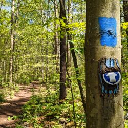
    I had been to the Thornton Bales Conservation Area before and couldn't quite make it to Joker's…read moreHill due to rainfall in the area. However, today I found out that there's a parking lot for the Joker's Hill hiking trail. The parking lot is fairly large, but inconspicuous. There are no signs, so you just have to slow down as you near the entrance heading south on Bathurst because it's easy to miss. I recommend wearing bug spray and long sleeve shirts and pants because there are signs indicating that there are ticks in the area. I also recommend wearing proper hiking shoes because there are areas that get muddy, depending on how far you hike. Don't forget to bring water. The trail starts off on the right and is shaded. Another trail head starts heading straight from the parking lot. I took the one that went straight. That trail starts off very narrow and passes by residential houses until you eventually reach a wider trail. The trail markers are dark blue. It's important that you know how to follow a trail and know how to read the trail markers because I'd say 95% of the trail is marked well and it's easy to go off the trail if you're not paying attention. I used my phone's GPS and Google Maps to figure out where I was located, though Google Maps doesn't show the trail that I was on. The trail merges with other trails. The blue trail markers turned into red and white. I believe the red trail markers are for the loop that starts off to the right of the Joker's Hill trail parking lot. I followed the white trail markers to the end of the Joker's Hill hiking trail, where I entered the Thornton Bales Conservation Area. The trail markers turn light blue. At the end of that trail are the 99 Steps. In total, it's a little over 5,000 steps and about 50 minutes to hike from the Joker's Hill parking lot to the 99 Steps parking lot. Overall, a pretty decent hike.

    Photos
    Joker's Hill Hiking Trail - The trail is well marked

    The trail is well marked

    Joker's Hill Hiking Trail
    Joker's Hill Hiking Trail - Wide trail

    See all

    Wide trail

    Mono Cliffs Provincial Park

    Mono Cliffs Provincial Park

    4.4(10 reviews)
    78.6 km

    Decided that thanks to COVID that I would explore more of the trails/parks that are close by…read more About 1.5 hrs from Toronto, this is a great hiking spot with good paths marked (although watch out for the horse poop!) and great views. There are multiple trails (named/colour coded), but the blue marked trail seems to be the "main" trail. I think the green trail takes you up to the viewing platform where you get some lovely views - I can only imagine when the leaves start changing colour - it must be epic! There is a map slightly into the entrance - i took a photo of it so I could see how all the different paths interconnected. Fairly large parking lot - you can only pay for either 4hrs or all day parking - there is no option to pay for anything less (but luckily it is not too expensive). I came on a random weekday so it was pretty dead - which was perfect! Lots of bugs so bug spray is a must. There really isn't any sitting areas - ie - no picnic areas/grass areas/benches to sit...it's definitely more of a walk walk hike hike area. Overall, it's a fairly easy and enjoyable hike. I'd love to come back in the fall and see the changing scenery!

    One of my favourite hikes! We went on a Sunday afternoon and the weather called for slight chance…read moreof light rain. Luckily this made it easy to get a parking spot, and the park was not busy at all. There are certain areas of the trail that are bit more difficult, but so enjoyable. Can easily spend hours here; can't wait to be back!

    Photos
    Mono Cliffs Provincial Park
    Mono Cliffs Provincial Park
    Mono Cliffs Provincial Park

    See all

    Wye Marsh Wildlife Centre - lakes - Updated September 2026

    Loading...
    Loading...
    Loading...