Cancel

    Open app

    Search

    Alander Mountain Trail

    4.0 (1 review)

    Alander Mountain Trail Photos
    Recommended Reviews - Alander Mountain Trail

    Your trust is our priority, so businesses can't pay to alter or remove their reviews. Learn more about reviews.
    Yelp app icon
    Browse more easily on the app
    Review Feed Illustration

    2 years ago

    Helpful 1
    Thanks 0
    Love this 0
    Oh no 0

    Verify this business for free

    People searched for Hiking 304 times last month within 15 miles of this business.

    Verify this business

    Bash Bish Falls - Waterfall blocked by unnecessary protection.

    Bash Bish Falls

    4.3(71 reviews)
    2.5 mi

    It took me three attempts over three days to make it all the way to the waterfall, but it was so…read moreworth it! I took this journey at the start of February, and there was tons of snow on the ground. On the first day, I arrived at the Massachusetts parking lot around 3 PM I figured I had a good two hours before sundown. I turned back after walking a short way down the trail because it was so steep, I thought I was going to tumble into the river. When I got back, I watched a video of someone hiking on the Massachusetts side, and I realized that the trail is normally full of stairs This makes sense because it's very steep and that's why it's so short but because of the snow, the stairs are covered up I would definitely not recommend using the Massachusetts side in the winter On the second day, I got to the New York parking lot around 2 PM. I made it about halfway down the much more gradual and scenic trail before I turned back. I turned back because the sun disappeared behind the mountain, and it was dark and windy On the third day, I got to the New York side at 11 AM. This time I realized that the top of the trail is just always dark and windy because it's in a corridor between two mountain peaks. So I pressed on. It took me about one hour to get to the end of the trail. I walked pretty slowly and stopped to look at nature a lot. If you are not someone who is super confident staying on the path in the forest, these are fairly easy trails because it's just a straight line the whole way there and you are following the river the whole time. I'm so glad I didn't give up because the falls are one of the most beautiful magical things I've ever seen Instead of water flowing down through the ice, it was snow and slush bursting through the sections of the frozen waterfall the water exploding into 1 million tiny snowflakes from the top to the bottom I plan to come back here in the summer with my kids and I think they will really love it.

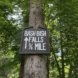
    Bash Bish Falls was just as beautiful as everyone says it is! The hike was worth every step, and…read moreseeing the waterfall in person was amazing. There's just something about being surrounded by nature that fills my cup. I LOVE to hike so this was my happy place. Even better, we got to share the experience with friends we've had for 24 years after meeting on a cruise. Good friends, beautiful scenery, and another memory made together. That's my kind of day. You can go I on the MA side which has lots of stairs but is a shorter walk or do the NY side with a short 3/4 mile hike to the falls.

    Photos
    Bash Bish Falls
    Bash Bish Falls - We came in on the NY side and hiked a bit

    We came in on the NY side and hiked a bit

    Bash Bish Falls

    See all

    Bear Mountain - Fall foliage

    Bear Mountain

    4.6(12 reviews)
    4.4 mi

    I hiked this mountain on October 18, 2024. I hiked Bear Mountain trail. Bear mountain did not…read moredisappoint. The fall foliage was beautiful. So many yellows and oranges. The was one little fly that we seem to make friends with. The scrabbles were good and a nice mix up to the trail. The trail was well marked and maintained. We were able to stand on the CT/MA line. The trail was about 6.5 miles long.

    As the tallest peak in Connecticut (2,300 ft.) Bear Mountain has to be one of my favorite CT hikes…read more There are several ways up to the summit, all of which are steep, long, and strenuous. On our most recent visit, we used Lion's Head. Although it's a bit longer than the Undermountain Trail, it's less vigorous and I think it has some really spectacular views. This is the perfect spot if you love panoramic overviews. From several lookouts, you can actually take in some great long-distance views. The southern part of Connecticut spreads out in front of you with the rolling Litchfield Hills to the south, Twin Lakes east, Massachusetts north-northeast, and surrounding mountainsides, farmland, woodlands, and small towns fill in the pieces of this picturesque puzzle (no western views). If you use Lion's head to reach the summit of Bear Mountain, it's a 6-mile round trip. As you near the top, the Appalachian Trail appears and is marked with white hash marks whereas the Lion's Head trail is marked by blue hash marks. Keep this in mind for your return trip or you be going off course! FYI: Park at the dirt parking lot on Bunker Hill Rd on the labeled "hiker parking" lot. All in all, the hike(s) up to Bear Mountain are tough and challenging even for the average day-hiker. With some patience, plenty of water and snacks, some determination and good company, Bear Mountain will be a great day-hike for any level. If you're feeling fancy, bring a bottle of wine and actual food and have a picnic at the summit. And if that still isn't enough, don't forget the journey's reward -- great overviews, Appalachian Trail access, title of hiking Connecticut's highest peaks, waterfalls, and woodlands.

    Photos
    Bear Mountain - On the CT/MA line

    On the CT/MA line

    Bear Mountain
    Bear Mountain

    See all

    Kaaterskill Falls - March 2026

    Kaaterskill Falls

    4.6(168 reviews)
    29.2 mi

    The falls are truly incredible…read more The trail down to the bottom of the falls, is a bit tricky. But so incredibly worth it. I would suggest not to believe the sign saying 189 steps.... it is definitely more! Take drinking water because you'll need that for sure. We went back in August and the heat was definitely there. The parking lot was pretty packed but throughout the trails people were pretty evenly spaced out. Not so much at the base of the falls themselves but there was still plenty of room to move around freely.

    A very mild and easy hike with a beautiful payoff! Definitely bring your bathing suits because you…read morecan take a dip in the water--it's cool, refreshing, and perfect for cooling off after the walk. The waterfall and surrounding scenery are absolutely beautiful, and you can easily spend some time relaxing on the rocks and taking in the view. You don't have to get in the water if that's not your thing; there are plenty of rocks around the area where you can sit and enjoy the scenery. There are both upper and lower sections of the waterfall, so depending on how much walking you want to do, you can choose which area to explore. We walked to the lookout point first, which gives you a view of the waterfall from above. From up there, everyone below looks like little ants! Before reaching the bridge, there are stairs that lead down to the actual waterfall, which I definitely recommend checking out. Overall, it's a beautiful spot, and the hike is very manageable!

    Photos
    Kaaterskill Falls - View Of Stream

    View Of Stream

    Kaaterskill Falls
    Kaaterskill Falls

    See all

    Alander Mountain Trail - hiking - Updated September 2026

    Loading...
    Loading...
    Loading...