American Tobacco Trail Photos


More like American Tobacco Trail
Recommended Reviews - American Tobacco Trail
Start your review...

Reviews With Photos

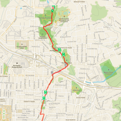
We finally checked out the American Tobacco Trail, one of the places in Durham with paved bikeable trails! After reading other Yelp reviews on safer vs. sketchier stretches of the trail, we decided to start out on Saturday morning at the parking lot near Southpoint Mall, off of Fayetteville road. The parking lot there can hold about 10-20 cars or so; we were able to find a space easily. From there we biked south 6 miles and then 6 miles back to the parking lot. The trail is well-marked although at a few parts of the beginning that wrap around Kroger and the shopping center we had to kind of guess where the trail continued. I like that the trail has varied scenery and a few benches or areas to rest along the way too! It crosses the main road only twice or so where you have to keep an eye out for cars. Otherwise it's a separate paved 2-laned trail. Since it's still a bit cold outside there weren't too many people out on the trail, but we did run into a lot of running groups, joggers, and bicyclists. I can see how the trail might get a little congested when it gets warmer. The terrain is mostly flat with a few hilly areas, and the part near Southpoint even has a few lamps. A helpful map of the trail: http://www.triangletrails.org/pdfs/ATT_map_page1-2015.pdf http://www.triangletrails.org/pdfs/ATT_map_page2-edited.pdf We'll be back on a longer bike ride next time!

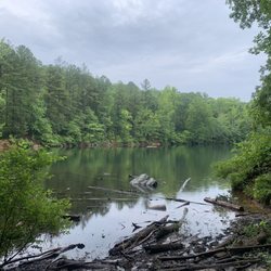
I love walking on the American Tobacco Trail and there are plenty of entrance points along this 20+ mile stretch. I have also biked on the trail and on some parts near Apex you will see horses. I have parked at the White Oak entrance in Apex and most recently in Durham in Fayetteville Street. I have always wondered where the bridge that crosses 40 goes and just found the entrance near the intersection of 54 and Fayetteville Street. The path is paved and bikers and runners did a good job of announcing "on your left". You pass residential parts and there are a few cross walks where you need to press the light to alert the drivers. All in all, it was a great walk on a pretty fall day and easy to park and navigate.

I absolutely love the American Tobacco Trail! It's a perfect little getaway to get yourself submerged into nature, and away from the city bustle and highways. I live just behind the trail by the Southpoint area and LOVE the new foot bridge that was recently completed!! It now connects the trail east of the NC 40 across to the Southpoint Mall! Whatever better way to get exercise on your way to some shopping!? The trail is miles and miles long and takes you into Downtown Durham. On a sunny day in the spring, it's so green and gorgeous, it's perfect for a run or nice walk with your dog. I highly recommend walking the trail off Fayetteville because it connects to Sutton Station where you can take a break for some gelato at Dulce Cafe on a hot day!!

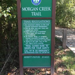
Today, as I was beginning my workout on the ATT, I saw a giant black snake crossing my path. I am more city than country, so I was a little freaked out, as he slithered into the grass on the side of the trail. A guy was jogging behind me and I stopped to tell him what I saw... he informed me it was just a rat snake. And I felt silly... well I am considering my American Tobacco Trail cherry: POPPED. I have not traveled the entire trail, I frequent the area that is between miles 10 - 13 on the lower portion (around Fayetteville Rd, Scott King Rd, Chatham County). It is really gorgeous and empowering... so calm and peaceful! If you can't focus on your workout here, I don't know where else you could go! But I would like to remind people that it is NOT paved in many places. Do not wear sandals while you walk on the ATT! I have seen really giant spiders, and from my recent (and first) rat snake sighting, please remember that you are in the WOODS and dress accordingly! Also, look out for horse droppings. It's kinda funny that dogs need to be cleaned up after but not horses? Stepping in dog poo is gross, but step in some horse poo and you have ruined a pair of shoes! (Yes, I know there is probably no practical way for horse riders to clean up after their horses) They have a really great map on their website that shows you where you can park to enjoy the trail. Also if parking is filled up along the Scott King Rd entrance (which it does on a nice day), you can park in Herndon Park. There is a paved path between two baseball fields that goes straight to the trail (under the power lines).

As far as running trails in Durham, American Tobacco Trail is by far my favorite. Mostly paved and with no sharp hills since it used to be a railroad track. The trail runs through all Durham's "major attractions" (Southpoint to Downtown and beyond). I usually jump on the trail between Cornwallis and MLK and run left or right. I love that the trail is mostly shaded, paved and has no major hills (on some days I just can't do hills, I'm not an expert runner yet people!) I usually see a lot of people biking the trail, especially during prime "get to work" and "get out of work" hours. There are flashing yellow lights that you can hit to let pedestrians cross busy roads and crosswalks over all busy roads as well where the trail cuts through. Depending on where you hit the trail, you may have to cross over roadways every 1-1.5 miles, but again, all dependent on where you pick it up. Along my run, there are several "branch offs" of the trail as well. For example, I have a real hesitation to run past Fayetteville Street when I'm alone, believe me when you see it you'll know why. It just gives me severe warning signs and memories from last years "incidents". But then I'm left in a dilemma as to where to go next. Luckily, ATT has an offshoot on Riddle Road that leads all the way into RTP and offers a seemingly safer path. If you live in Durham, you'll have heard some horror stories about runners getting mugged on the ATT. I NEVER run the trail at night or dusk because of this (plus the trail technically closes at sunset). However, I often run the trail by myself during the day, just keep your wits about you, I always carry my phone. Also, I have seen police patrolling the trail in golf carts, usually heading towards the Fayetteville intersection (glad to know that my instincts aren't skewed) and I've heard since the attacks last summer security has gotten tighter. The only other downside of the trail are lack of water stops and bathrooms. While there are a handful scattered around the trail, make sure you take necessary precautions before your run. And just get out there and DO IT! ATT is a great trail for beginners and intermediate training alike and the mile markers every .25 miles are always kept fresh! NOTE: If you don't live close to or on the ATT, the best place to start is at the beginning. Begins right downtown underneath the highway, across from the Bulls stadium. Park in the parking deck at American Tobacco Campus! Also, if you have a YMCA membership, you can shower up and change at the YMCA too!

So much Fun! What a great trail from downtown Durham to the Streets at South Point Mall. My wife and I had a wonderful time riding the eight mile section of this trail. The trail is well maintained and has mile markers every quarter mile. We found the ride to be very easy, great for beginner cyclists. It took us only 35-40 minutes to casually bike from downtown Durham to the mall. We highly recommend taking some time to enjoy this trail. Enjoy!

A quality rail to trail project, this outdoor attraction adjoins some other parklands, and is far enough from the downtown of any of the nearby metropolitan areas to be relatively quiet and safe and to offer some interesting views of the countryside. Having said that, it's long enough that there are sections of it for which the verdict is apparently different. Everything was in good condition when I visited, though water fountains in the neighboring park were shut off for the winter. read more


At first, I thought the trail would be inundated with tobacco products but learned that it was just the name. The trail goes on forever! We walked for two hours. The scenery was nice and trail was super safe during the day. Highly recommend this trail! There's a lot of trees, bushes, plants, flowers. Some people bike, walk, skateboard, or rollerblade. read more


3 years ago
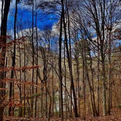
OK. This trail saved my literal life, lol. I was staying at a nearby hotel and experiencing 12h work days with my team. We love to see it, the hustle, the grind, the capitalism on a j-curve. However, the hotel gym was covered in glass where anyone could see me jiggling and perishing and I do my best jogging outside. I asked my local coworker for a running recommendation and he suggested this trail, saying basically I wouldn't be alone, for better or worse, there are always people on this trail. I needed to be AWAY from work, to clear my head, to improve my mental health and as a bonus, get a little cardio in for my heart. It starts conveniently near the stadium and idk how far it goes because I only did 3mi (1.5mi out and back). I'm somewhat of a nervous, anxious person and I worried mainly about getting stabbed (Portland, OR represent!), being preyed on by wildlife (some of the this-used-to-be-an-old-railroad slices thru the hills made me think of trails where I grew up that had cougars occasionally spotted with the seldom bear). But this trail was so beautiful! The leaves were orangey, there were so many people walking well-behaved dogs and I never felt lonely or at risk. I ran with both headphones in around 7am at a brisk 28 degrees and found the trail wholly lovely. Something I noticed that I loved (and normally don't see, especially in my regular neighborhood route) was the distance marking every .25 mi. It was really nice to know I didn't have to keep looking at my watch to see my distance, I always knew within a 1/4 mi how far out I was from the start. Anyone visiting Durham would enjoy this I think, for walking or jogging, unless you're really looking for something more isolated. If I find myself in Durham again, I'd absolutely do my jogging here, unless it was humid because I live in the PNW and the humidity does not suit my temperament. read more
3 years ago
We finally checked out the American Tobacco Trail, one of the places in Durham with paved bikeable trails! After reading other Yelp reviews on safer vs. sketchier stretches of the trail, we decided to start out on Saturday morning at the parking lot near Southpoint Mall, off of Fayetteville road. The parking lot there can hold about 10-20 cars or so; we were able to find a space easily. From there we biked south 6 miles and then 6 miles back to the parking lot. The trail is well-marked although at a few parts of the beginning that wrap around Kroger and the shopping center we had to kind of guess where the trail continued. I like that the trail has varied scenery and a few benches or areas to rest along the way too! It crosses the main road only twice or so where you have to keep an eye out for cars. Otherwise it's a separate paved 2-laned trail. Since it's still a bit cold outside there weren't too many people out on the trail, but we did run into a lot of running groups, joggers, and bicyclists. I can see how the trail might get a little congested when it gets warmer. The terrain is mostly flat with a few hilly areas, and the part near Southpoint even has a few lamps. A helpful map of the trail: http://www.triangletrails.org/pdfs/ATT_map_page1-2015.pdf http://www.triangletrails.org/pdfs/ATT_map_page2-edited.pdf We'll be back on a longer bike ride next time! read more


9 years ago
I love walking on the American Tobacco Trail and there are plenty of entrance points along this 20+ mile stretch. I have also biked on the trail and on some parts near Apex you will see horses. I have parked at the White Oak entrance in Apex and most recently in Durham in Fayetteville Street. I have always wondered where the bridge that crosses 40 goes and just found the entrance near the intersection of 54 and Fayetteville Street. The path is paved and bikers and runners did a good job of announcing "on your left". You pass residential parts and there are a few cross walks where you need to press the light to alert the drivers. All in all, it was a great walk on a pretty fall day and easy to park and navigate. read more


6 years ago
12 years ago
I absolutely love the American Tobacco Trail! It's a perfect little getaway to get yourself submerged into nature, and away from the city bustle and highways. I live just behind the trail by the Southpoint area and LOVE the new foot bridge that was recently completed!! It now connects the trail east of the NC 40 across to the Southpoint Mall! Whatever better way to get exercise on your way to some shopping!? The trail is miles and miles long and takes you into Downtown Durham. On a sunny day in the spring, it's so green and gorgeous, it's perfect for a run or nice walk with your dog. I highly recommend walking the trail off Fayetteville because it connects to Sutton Station where you can take a break for some gelato at Dulce Cafe on a hot day!! read more


15 years ago
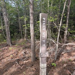
Today, as I was beginning my workout on the ATT, I saw a giant black snake crossing my path. I am more city than country, so I was a little freaked out, as he slithered into the grass on the side of the trail. A guy was jogging behind me and I stopped to tell him what I saw... he informed me it was just a rat snake. And I felt silly... well I am considering my American Tobacco Trail cherry: POPPED. I have not traveled the entire trail, I frequent the area that is between miles 10 - 13 on the lower portion (around Fayetteville Rd, Scott King Rd, Chatham County). It is really gorgeous and empowering... so calm and peaceful! If you can't focus on your workout here, I don't know where else you could go! But I would like to remind people that it is NOT paved in many places. Do not wear sandals while you walk on the ATT! I have seen really giant spiders, and from my recent (and first) rat snake sighting, please remember that you are in the WOODS and dress accordingly! Also, look out for horse droppings. It's kinda funny that dogs need to be cleaned up after but not horses? Stepping in dog poo is gross, but step in some horse poo and you have ruined a pair of shoes! (Yes, I know there is probably no practical way for horse riders to clean up after their horses) They have a really great map on their website that shows you where you can park to enjoy the trail. Also if parking is filled up along the Scott King Rd entrance (which it does on a nice day), you can park in Herndon Park. There is a paved path between two baseball fields that goes straight to the trail (under the power lines). read more

As far as running trails in Durham, American Tobacco Trail is by far my favorite. Mostly paved and with no sharp hills since it used to be a railroad track. The trail runs through all Durham's "major attractions" (Southpoint to Downtown and beyond). I usually jump on the trail between Cornwallis and MLK and run left or right. I love that the trail is mostly shaded, paved and has no major hills (on some days I just can't do hills, I'm not an expert runner yet people!) I usually see a lot of people biking the trail, especially during prime "get to work" and "get out of work" hours. There are flashing yellow lights that you can hit to let pedestrians cross busy roads and crosswalks over all busy roads as well where the trail cuts through. Depending on where you hit the trail, you may have to cross over roadways every 1-1.5 miles, but again, all dependent on where you pick it up. Along my run, there are several "branch offs" of the trail as well. For example, I have a real hesitation to run past Fayetteville Street when I'm alone, believe me when you see it you'll know why. It just gives me severe warning signs and memories from last years "incidents". But then I'm left in a dilemma as to where to go next. Luckily, ATT has an offshoot on Riddle Road that leads all the way into RTP and offers a seemingly safer path. If you live in Durham, you'll have heard some horror stories about runners getting mugged on the ATT. I NEVER run the trail at night or dusk because of this (plus the trail technically closes at sunset). However, I often run the trail by myself during the day, just keep your wits about you, I always carry my phone. Also, I have seen police patrolling the trail in golf carts, usually heading towards the Fayetteville intersection (glad to know that my instincts aren't skewed) and I've heard since the attacks last summer security has gotten tighter. The only other downside of the trail are lack of water stops and bathrooms. While there are a handful scattered around the trail, make sure you take necessary precautions before your run. And just get out there and DO IT! ATT is a great trail for beginners and intermediate training alike and the mile markers every .25 miles are always kept fresh! NOTE: If you don't live close to or on the ATT, the best place to start is at the beginning. Begins right downtown underneath the highway, across from the Bulls stadium. Park in the parking deck at American Tobacco Campus! Also, if you have a YMCA membership, you can shower up and change at the YMCA too! read more


11 years ago
So much Fun! What a great trail from downtown Durham to the Streets at South Point Mall. My wife and I had a wonderful time riding the eight mile section of this trail. The trail is well maintained and has mile markers every quarter mile. We found the ride to be very easy, great for beginner cyclists. It took us only 35-40 minutes to casually bike from downtown Durham to the mall. We highly recommend taking some time to enjoy this trail. Enjoy! read more


11 years ago
This is an absolutely beautiful trail, and it's easy to ride too. That said, many parts of it feel isolated and unsafe, so I only ride my bike on this trail, not walk--I guess I feel safer going a bit faster. Last year there were some truly terrifying reports of people getting bludgeoned by a hammer-wielding mugger. Instead of demanding wallets he'd apparently just hit people in the head with a hammer and rob them. Don't know if he was ever caught. I heard patrols of the trail got stepped up after that, but I never saw any. read more


7 years ago
15 years ago
18 years ago
13 years ago
16 years ago
15 years ago
16 years ago
15 years ago
11 years ago
14 years ago
8 years ago
11 years ago
8 years ago
10 years ago
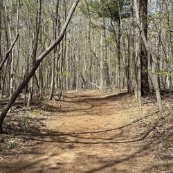
Beautiful trail where I started by south point mall. Looked kind of magical with all the trees and their shadows like a tunnel kind of. New favorite. read more


7 years ago
9 years ago
Page 1 of 2
More info about American Tobacco Trail
Ask the Community - American Tobacco Trail
Review Highlights - American Tobacco Trail


Why does Yelp recommend reviews?
3 reviews that are not currently recommended
The reviews below are not factored into the business's overall star rating.
11 years ago
13 years ago
9 years ago
American Tobacco Trail - hiking - Updated June 2026
Best of Durham
People found American Tobacco Trail by searching for…
Attractions in Durham, North Carolina
Lakes in Durham, North Carolina
Parks in Durham, North Carolina
Public Shower in Durham, North Carolina
Walking Trails in Durham, North Carolina
Watch Sunset in Durham, North Carolina
Things to Do in Durham, North Carolina
Beautiful Views in Durham, North Carolina
Running Trails in Durham, North Carolina
Sunset View in Durham, North Carolina
Hiking Trails With Waterfalls in Durham, North Carolina
Off Road Trails in Durham, North Carolina
Parks for Kids in Durham, North Carolina
Free Parking in Durham, North Carolina
Night Hike in Durham, North Carolina
Night View in Durham, North Carolina
Flower Field in Durham, North Carolina
Basketball Courts in Durham, North Carolina
Playgrounds in Durham, North Carolina
Picnic Areas in Durham, North Carolina
Dog Friendly Hiking Trails in Durham, North Carolina
Waterfalls in Durham, North Carolina
Trending Searches in Durham, NC
Bait And Tackle Shop near American Tobacco Trail
Bird Sanctuary near American Tobacco Trail
Black Owned Nail Salons near American Tobacco Trail
Boat Rental near American Tobacco Trail
Cliff Jumping near American Tobacco Trail
Creeks near American Tobacco Trail
Day Trips near American Tobacco Trail
Dog Friendly Trails near American Tobacco Trail
Fishing Spots near American Tobacco Trail
Jet Ski Rental near American Tobacco Trail
Kayak Rental near American Tobacco Trail
Lakes & Ponds near American Tobacco Trail
Outdoor Activities near American Tobacco Trail
Pick Your Own Farms near American Tobacco Trail
Places To Walk Around near American Tobacco Trail
Public Shower near American Tobacco Trail
River Swimming near American Tobacco Trail
Rock Quarry near American Tobacco Trail
Scenic Night View near American Tobacco Trail
Scenic Overlook near American Tobacco Trail
Secluded Spots near American Tobacco Trail
Soccer Store near American Tobacco Trail
Splash Pad near American Tobacco Trail
Strawberry Picking near American Tobacco Trail
Sunrise View near American Tobacco Trail
Swimming Holes near American Tobacco Trail
Swimming Lakes near American Tobacco Trail
Swimming Pools near American Tobacco Trail
Browse Articles
Browse Nearby
Browse Brands
Related Searches in Durham, NC
Affordable Kayak Rental Services in Durham, North Carolina
Best Fishing Locations and Guides in Durham, North Carolina
Best Places for Horseback Riding in Durham, North Carolina
Check Out Off Road Trails in Durham, North Carolina
Discover Kid Friendly Hiking Trails in Durham, North Carolina
Discover Scenic Mountain Bike Trails Near Durham, North Carolina
Discover Scenic Waterfall Spots in Durham, North Carolina
Discover Top State Parks to Visit in Durham, North Carolina
Discover a Hiking Trail in Durham, North Carolina
Discover the Best Night Hike Trails in Durham, North Carolina
Dog-Friendly Hikes With Dogs in Durham, North Carolina
Enjoy Camping Adventures Around Durham, North Carolina
Enjoy Exciting Mountain Biking Adventures in Durham, North Carolina
Enjoy Kayaking Adventures in Durham, North Carolina
Enjoy River Tubing Adventures in Durham, North Carolina
Enjoy Tent Camping Spots Around Durham, North Carolina
Enjoy a Beautiful Waterfall Hike in Durham, North Carolina
Enjoy the Best Picnic Spots and Ideas in Durham, North Carolina
Enjoy the Best Walking Trails in Durham, North Carolina
Explore Beautiful Parks and Green Spaces in Durham, North Carolina
Explore Easy Hikes Perfect for All in Durham, North Carolina
Explore Fun Activities to Do in Durham, North Carolina
Explore Popular Campgrounds Near Durham, North Carolina
Explore Popular Scenic Overlook Points in Durham, North Carolina
Explore the Best Beach Spots in Durham, North Carolina
Explore the Best Boating Spots in Durham, North Carolina
Explore the Best Swimming Holes Around Durham, North Carolina
Explore the Best Trail Options in Durham, North Carolina
Family Friendly Hiking With Kids in Durham, North Carolina
Find Beautiful Views in Durham, North Carolina
Find Popular Ziplining Spots Around Durham, North Carolina
Find the Best Parks for Picnics in Durham, North Carolina
Find the Best Scenic View Locations in Durham, North Carolina
Hiking Trails With Waterfalls in Durham, North Carolina
Must-See Sights to Explore in Durham, North Carolina
Off Leash Dog Hiking Trails in Durham, North Carolina
Plan a Scenic Drive Route Near Durham, North Carolina
Popular Fishing Spots to Explore in Durham, North Carolina
Popular Outdoor Activities to Try in Durham, North Carolina
Popular Picnic Spots to Visit in Durham, North Carolina
Safe River Swimming Areas in Durham, North Carolina
Safe and Fun Parks for Kids in Durham, North Carolina
Top Climbing Spots and Gyms in Durham, North Carolina
Top Paddleboarding Activities in Durham, North Carolina
Top Running Trails to Explore in Durham, North Carolina
Top Swimming Lakes to Enjoy in Durham, North Carolina
Top Swimming Spots and Pools in Durham, North Carolina
Top Things to Do With Kids in Durham, North Carolina
Walk Dog Friendly Hiking Trails in Durham, North Carolina
Walk the Best Paved Walking Trails in Durham, North Carolina
People who viewed American Tobacco Trail also viewed
Third Fork Creek Trail
7 reviews
Ellerbe Creek Trail
7 reviews
Duke Forest, Korstian Division
9 reviews
White Oak Creek Greenway
3 reviews
William B Umstead State Park
185 reviews
Bolin Creek Greenway
20 reviews
Hollow Rock Nature Park
3 reviews
Lake Lynn Trail
19 reviews
American Tobacco Trail - Chatham & Wake
8 reviews
Johnston Mill Nature Preserve
10 reviews