Baden Powell Trail Photos


More like Baden Powell Trail
Recommended Reviews - Baden Powell Trail
Start your review...

Reviews With Photos

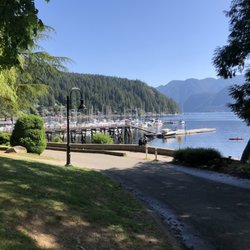
Just want to give some direction on where the trail starts from Deep Cove. Park at or near Panorama park. Go down to the dock, locate the washroom/shelter area. Walk towards north (left of shelter) on asphalt until you cross the street. Pay attention on the small sign that says "Baden Powell Trail" next to a residential house (see pic). Walk through it and you should see a staircase that is the start of the trail. I consider this part of the hike to be easy/medium difficulty. The view at Quarry Rock is amazing.

This trail is about 50 kms long through the North Shore mountains. The trail starts where Highway 99 (Sea-To-Sky) and Highway 1 diverge on the west, and on the East end, the trail starts in Panorama Park north from the heart of Deep Cove. I have done the East end of this trail, heading to the top of Quarry Rock in Deep Cove. There's parking lots and street parking, but on the weekends it could be limited. This is a relatively easy hike, there are stairways and bridges for easy access. It's about a 20 minute hike up, and then you are at the top of Quarry Rock! It's quite a beautiful sight, overlooking Deep Cove. After that, you can continue on the trail, which will eventually lead you to the Lynn Canyon Suspension Bridge as well. For a relaxing hike, this is the place to come. Go for a picnic in Panorama Park afterwards, visit the shops, or even go kayaking or canoeing in Deep Cove. You will not be disappointed!

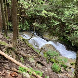
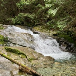
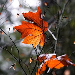
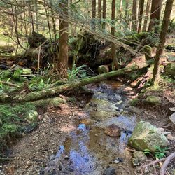
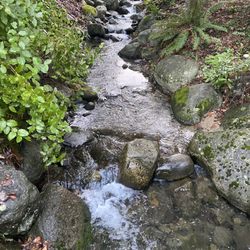
At first, the steps at the beginning had me a bit worried. I was winded and my legs were a bit unsure, but once you get past those stairs, the beauty of this trail takes over. I went hiking on the Baden Powell Trail the day after a huge rainstorm and it was quite dry and in good condition. I loved the many waterfalls and gullies. The walls of ferns and mossy trees are just breathtaking. And of course, the view from the top is just spectacular. On my hike I saw lots of people with dogs of all sizes, and people with babies in carriers and kids too. I went on Memorial Day weekend so Quarry Rock was pretty busy when we got up there. From the cute shops in Deep Cove to this wonderful trail, this is a perfect spot for any tourist or local looking for a relaxing day out.


Overall 4 Stars So the Baden Powell Trail is not for the faint at heart! It is considered a beginners trail however the trail is steeped with a lot of steps up and down the mountain trails. If you have weak knees or back, I recommend not to do it due to the steps and the distance to the No Name Rock - I made this up. Can find a name of the Rock peak anywhere ( the rock at the peak where you have a beautiful view of Deep Cove. You will "huff and puff" throughout the trail. Also, we saw people having to carry their pets with them because they were hot, short winded, or were the short legged breed. The trail itself is decently manicured with a lot of pressure treated wood for the steps and bridges. But the trail itself can be steep. I believe you will cross about 6 bridges before reaching the peak. It will take about 45 minutes (if you are in top shape) or more to reach the peak. I believe it took about 75 minutes due to popularity of the trail. Went around 4:30 PM on a Saturday during peak season. BRING WATER!!! We brought One 1Litre of Water each which was sufficient. Also, some snacks when you reach the "no name" rock. I really don't know if there is a name of the rock. I just call it that. The snacks is your reward with the view of the cove. It is spectacular! And we forgot ours! Don't make our mistake. I didn't take pictures of the steps and trail and I regret it now. However the trail itself is pretty and there are sections where the salty breeze feels lovely on your glistening skin. HAHA! The trail is about 2.2 kilometers or 1.37 miles from beginning to the No Name Rock - aka the Peak then 2.2 miles back. It is quicker coming down. Just give yourself rest during the train. It can get narrow and there are limited bench seats. Cons: 1. Limited bench seats 2. No signs to tell how far you come along or how far you have to go. I wish they will add a sign in the bridges as a Marker Point. The trail only has a beginning and ending sign 3. Trails on the steps can be narrow. Take your time. It is not a race. Advice: 1. Wear good comfortable shoes. Trail can be rocky and soil slippery at times. 2. Be courteous to other people on the trail. Some were oblivious on the people on the trail taking selfies or videos by blocking certain areas. Be patient and let the other people pass before you become an "influencer". When it is busy, it is not respectful. 3. Wear long sleeves early in the morning or later in the evening due to mosquitos. They seem to appear during those times. And when they saw me, it was "Asian Buffett" time! However, these mosquitoes were nothing like the ones in Alaska wear they will take you away for their feast or down in the South where they add some hot sauce on ya' before enjoy the entree'. Eat some Kimchi or garlic and they will stay away from you and maybe everyone else. Hmmm, that's not a bad idea! read more


6 years ago
8 years ago
This trial takes you to Quarry Rock with an amazing view of Deep Cove. It starts in a residential area and starts out with lots of stairs. It gets pretty slippery when it's raining. Being from LA, I definitely appreciated all the foliage and water - so beautiful! This trail also has the friendliest dogs running/playing around. read more


16 years ago
Just want to give some direction on where the trail starts from Deep Cove. Park at or near Panorama park. Go down to the dock, locate the washroom/shelter area. Walk towards north (left of shelter) on asphalt until you cross the street. Pay attention on the small sign that says "Baden Powell Trail" next to a residential house (see pic). Walk through it and you should see a staircase that is the start of the trail. I consider this part of the hike to be easy/medium difficulty. The view at Quarry Rock is amazing. read more


This trail is about 50 kms long through the North Shore mountains. The trail starts where Highway 99 (Sea-To-Sky) and Highway 1 diverge on the west, and on the East end, the trail starts in Panorama Park north from the heart of Deep Cove. I have done the East end of this trail, heading to the top of Quarry Rock in Deep Cove. There's parking lots and street parking, but on the weekends it could be limited. This is a relatively easy hike, there are stairways and bridges for easy access. It's about a 20 minute hike up, and then you are at the top of Quarry Rock! It's quite a beautiful sight, overlooking Deep Cove. After that, you can continue on the trail, which will eventually lead you to the Lynn Canyon Suspension Bridge as well. For a relaxing hike, this is the place to come. Go for a picnic in Panorama Park afterwards, visit the shops, or even go kayaking or canoeing in Deep Cove. You will not be disappointed! read more


At first, the steps at the beginning had me a bit worried. I was winded and my legs were a bit unsure, but once you get past those stairs, the beauty of this trail takes over. I went hiking on the Baden Powell Trail the day after a huge rainstorm and it was quite dry and in good condition. I loved the many waterfalls and gullies. The walls of ferns and mossy trees are just breathtaking. And of course, the view from the top is just spectacular. On my hike I saw lots of people with dogs of all sizes, and people with babies in carriers and kids too. I went on Memorial Day weekend so Quarry Rock was pretty busy when we got up there. From the cute shops in Deep Cove to this wonderful trail, this is a perfect spot for any tourist or local looking for a relaxing day out. read more


10 years ago
Beautiful trail (even in the pouring rain!) but very easy to get lost. Many trails cross each other, so bring a map, a phone with GPS or a trail tracking app or risk potentially walking in circles for hours. We got better directions from the hikers and bikers, which were very friendly, but the trails could use better/clearer markers. read more


More info about Baden Powell Trail
300 Panorama Drive
North Vancouver, BC V7G 1L2
Canada
Deep Cove
Directions
Hours
Outdoor Amenities
Review Highlights - Baden Powell Trail


Baden Powell Trail - hiking - Updated July 2026
People found Baden Powell Trail by searching for…
Beaches in North Vancouver, BC
Hiking Trails With Waterfalls in North Vancouver, BC
Stairs Workout in North Vancouver, BC
Lookout Points in North Vancouver, BC
Secluded Spots in North Vancouver, BC
Places to Take Pictures in North Vancouver, BC
Walking Trail in North Vancouver, BC
Scenic View in North Vancouver, BC
Waterfalls and Swimming Holes in North Vancouver, BC
Off Leash Dog Hikes in North Vancouver, BC
Dog Friendly Hiking Trails in North Vancouver, BC
Swimming Lakes in North Vancouver, BC
Beautiful Views in North Vancouver, BC
Picnic Parks in North Vancouver, BC
Running Trails in North Vancouver, BC
Picnic Areas in North Vancouver, BC
Lakes & Ponds in North Vancouver, BC
Picnic Spots in North Vancouver, BC
Things to Do With Kids in North Vancouver, BC
Browse Articles
Browse Brands
Related Searches in North Vancouver, BC
Affordable Kayak Rental Services in North Vancouver, British Columbia
Best Fishing Locations and Guides in North Vancouver, British Columbia
Best Places for Horseback Riding in North Vancouver, British Columbia
Best Sightseeing Experiences Available in North Vancouver, British Columbia
Check Out Off Road Trails in North Vancouver, British Columbia
Discover Popular Bike Trails in North Vancouver, British Columbia
Discover Scenic Mountain Bike Trails Near North Vancouver, British Columbia
Discover the Best Beaches in North Vancouver, British Columbia
Discover the Best Night Hike Trails in North Vancouver, British Columbia
Enjoy Camping Adventures Around North Vancouver, British Columbia
Enjoy Exciting Mountain Biking Adventures in North Vancouver, British Columbia
Enjoy Kayaking Adventures in North Vancouver, British Columbia
Enjoy Off Leash Dog Hikes in North Vancouver, British Columbia
Enjoy Scenic Places to Walk in North Vancouver, British Columbia
Enjoy Tent Camping Spots Around North Vancouver, British Columbia
Enjoy Water Activities and Fun in North Vancouver, British Columbia
Enjoy the Best Walking Trails in North Vancouver, British Columbia
Experience Stunning Sunset Views in North Vancouver, British Columbia
Experience Thrilling White Water Rafting in North Vancouver, British Columbia
Explore Beautiful Parks and Green Spaces in North Vancouver, British Columbia
Explore Fun Activities to Do in North Vancouver, British Columbia
Explore Popular Campgrounds Near North Vancouver, British Columbia
Explore Popular Dog Walking Trails in North Vancouver, British Columbia
Explore Scenic Lakes to Visit in North Vancouver, British Columbia
Explore Top Dog Parks in North Vancouver, British Columbia Near You
Explore Top Water Parks in North Vancouver, British Columbia Today
Explore the Best Beach Spots in North Vancouver, British Columbia
Find Beautiful Views in North Vancouver, British Columbia
Find Parks and Recreation Activities in North Vancouver, British Columbia
Find Top-Rated Waterfalls in North Vancouver, British Columbia Now
Find the Best Playgrounds to Visit in North Vancouver, British Columbia
Hiking Trails With Waterfalls in North Vancouver, British Columbia
Plan a Scenic Drive Route Near North Vancouver, British Columbia
Popular Fishing Spots to Explore in North Vancouver, British Columbia
Popular Kids Activities in North Vancouver, British Columbia
Popular Outdoor Activities to Try in North Vancouver, British Columbia
Popular Picnic Spots to Visit in North Vancouver, British Columbia
Safe and Fun Parks for Kids in North Vancouver, British Columbia
Top Dog Friendly Things to Do in North Vancouver, British Columbia
Top Hiking Trails to Explore in North Vancouver, British Columbia
Top Playgrounds for Kids to Enjoy in North Vancouver, British Columbia
Top Running Trails to Explore in North Vancouver, British Columbia
Top Swimming Lakes to Enjoy in North Vancouver, British Columbia
Top Swimming Spots and Pools in North Vancouver, British Columbia
Top Things to Do With Kids in North Vancouver, British Columbia
Top-Rated Camping Sites in North Vancouver, British Columbia
Walk Dog Friendly Hiking Trails in North Vancouver, British Columbia
Walk the Best Paved Walking Trails in North Vancouver, British Columbia
Where to Catch the Best Sunrise View in North Vancouver, British Columbia