Darkesville Historical Marker Photos

More like Darkesville Historical Marker
Recommended Reviews - Darkesville Historical Marker
Start your review...

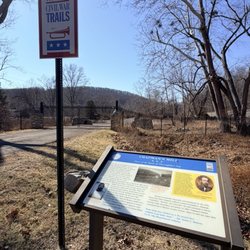
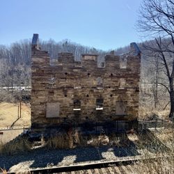
Along US-11, which they call Winchester Avenue here, this marker points out the local town that was named for a Revolutionary era hero. There is a small spot to stop. The marker reads, "Darkesville. Named for Gen. William Darke, veteran of the Revolution and the Indian wars. He saved the remnants of St. Clair's army from massacre in 1791 when badly defeated by the Miami Indians. His son, Capt. Joseph Darke, lost his life." Online, there is more information. Darkesville is an unincorporated community in Berkeley County, West Virginia, United States. Established in 1791, Darkesville has been nationally recognized as a historic district. Darkesville was recognized for its historic architecture, which includes approximately twenty-five buildings constructed as log cabins in 1810 or earlier. Darke served with British regulars commanded by Major General Edward Braddock in his 1755 expedition to the French-controlled Ohio Valley, as part of the French and Indian War. The British forces were defeated and Braddock died. Darke survived to be commissioned as a captain at the beginning of the American Revolutionary War. He was made prisoner at the Battle of Germantown. He was commanding colonel of the Hampshire and Berkeley regiments at the capture of General Cornwallis. Darke was often a member of the Virginia legislature and, during the convention of 1788, voted for the Federal Constitution and served as a major-general of the Virginia militia.. [Review 15117 overall, 619 of 2021, number 38 in West Virginia.] read more


More info about Darkesville Historical Marker


Darkesville Historical Marker - landmarks - Updated June 2026
Best of Inwood
People found Darkesville Historical Marker by searching for…
Trending Searches in Inwood, WV
Bait And Tackle Shop near Darkesville Historical Marker
Boat Rental near Darkesville Historical Marker
Bounce House Rentals near Darkesville Historical Marker
Caves near Darkesville Historical Marker
Cliff Jumping near Darkesville Historical Marker
Flower Shop near Darkesville Historical Marker
Golf Cart Rentals near Darkesville Historical Marker
Hidden Gems near Darkesville Historical Marker
Hiking near Darkesville Historical Marker
Landmarks & Historical Buildings near Darkesville Historical Marker
Lookout Points near Darkesville Historical Marker
Movie Theatre near Darkesville Historical Marker
Nurseries & Gardening near Darkesville Historical Marker
Pedicure near Darkesville Historical Marker
Pick Your Own Farms near Darkesville Historical Marker
Places To Visit near Darkesville Historical Marker
Public Services & Government near Darkesville Historical Marker
Scenic Drive near Darkesville Historical Marker
Secluded Spots near Darkesville Historical Marker
Splash Pad near Darkesville Historical Marker
Strawberry Picking near Darkesville Historical Marker
Summer Camps near Darkesville Historical Marker
Sunset View near Darkesville Historical Marker
Swimming Holes near Darkesville Historical Marker
Swimming Pools near Darkesville Historical Marker
Browse Articles
Browse Nearby
BEST of Inwood, West Virginia Restaurants near Darkesville Historical Marker
BEST of Inwood, West Virginia Coffee near Darkesville Historical Marker
BEST of Inwood, West Virginia Things to Do near Darkesville Historical Marker
BEST of Inwood, West Virginia Hiking near Darkesville Historical Marker
BEST of Inwood, West Virginia Shopping near Darkesville Historical Marker
BEST of Inwood, West Virginia Breakfast near Darkesville Historical Marker
BEST of Inwood, West Virginia Hotels near Darkesville Historical Marker
Browse Brands
Related Searches in Inwood, WV
Best Fun Things to Do in Inwood, West Virginia
Best Lookout Points to Visit in Inwood, West Virginia
Best Spots for Star Gazing in Inwood, West Virginia
Book Engaging Historical Tours in Inwood, West Virginia
Discover Charming Historic Homes in Inwood, West Virginia
Discover Family-Friendly Aquariums in Inwood, West Virginia
Discover Famous Monuments in Inwood, West Virginia
Discover Fun Things to Do Alone in Inwood, West Virginia
Discover Historic Sites and Places in Inwood, West Virginia
Discover Popular Photo Spots in Inwood, West Virginia
Discover Romantic Views in Inwood, West Virginia
Discover the Best Beaches in Inwood, West Virginia
Enjoy Hiking Adventures in Inwood, West Virginia
Enjoy the Best Night View Spots in Inwood, West Virginia
Enjoy the Best Walking Trails in Inwood, West Virginia
Explore Beautiful Botanical Gardens in Inwood, West Virginia
Explore Beautiful Parks and Green Spaces in Inwood, West Virginia
Explore Easy Hikes Perfect for All in Inwood, West Virginia
Explore Family-Friendly Zoos and Wildlife in Inwood, West Virginia
Explore Free Kids Activities Near Inwood, West Virginia
Explore Free Things to Do Around Inwood, West Virginia
Explore Fun Activities to Do in Inwood, West Virginia
Explore Popular Scenic Views Near Inwood, West Virginia
Explore Popular View Points Around Inwood, West Virginia
Explore Scenic Lakes to Visit in Inwood, West Virginia
Explore Secret Spots Worth Visiting in Inwood, West Virginia
Explore Top Art Galleries Located in Inwood, West Virginia
Explore Top Haunted Places Near Inwood, West Virginia
Explore Venues & Event Spaces in Inwood, West Virginia
Explore the Top Car Museum in Inwood, West Virginia
Find Beautiful Views in Inwood, West Virginia
Find Exciting Tours to Take in Inwood, West Virginia
Find Top Libraries to Visit in Inwood, West Virginia
Find Top-Rated Waterfalls in Inwood, West Virginia Now
Find the Best Bridge Spots in Inwood, West Virginia
Find the Best Playgrounds to Visit in Inwood, West Virginia
Hiking Trails With Waterfalls in Inwood, West Virginia
Must-See Tourist Attractions Around Inwood, West Virginia
Popular Outdoor Activities to Try in Inwood, West Virginia
Popular Picnic Spots to Visit in Inwood, West Virginia
Popular Things to Do in Inwood, West Virginia
Top Hiking Trails to Explore in Inwood, West Virginia
Top Places to Visit in Inwood, West Virginia for Sightseeing
Tour Famous Lighthouses Located in Inwood, West Virginia
Uncover the Best Secluded Spots Around Inwood, West Virginia
Visit Beautiful Gardens in Inwood, West Virginia
Visit Cultural Centers in Inwood, West Virginia
Visit Popular Museums in Inwood, West Virginia Now
Visit a Charming Gift Shop in Inwood, West Virginia
Where to Catch the Best Sunrise View in Inwood, West Virginia
People who viewed Darkesville Historical Marker also viewed
Lewis and Clark
1 review
Bolivar Heights Battlefield
9 reviews
Home Of The Jones Diamond
1 review
James Rumsey Monument
4 reviews
The Retreat Historical Marker
1 review
Antietam National Cemetery
1 review
Point of Rocks Bridge
4 reviews
Winchester and Potomac Railroad Bridge
1 review
Storer College Campus
1 review
U S Armory Site
1 review