Cancel

    Open app

    Search

    Fall Creek Falls Trailhead

    4.3 (3 reviews)

    Fall Creek Falls Trailhead Photos

    Recommended Reviews - Fall Creek Falls Trailhead

    Your trust is our priority, so businesses can't pay to alter or remove their reviews. Learn more about reviews.
    Yelp app icon
    Browse more easily on the app
    Review Feed Illustration

    1 year ago

    Helpful 0
    Thanks 0
    Love this 0
    Oh no 0
    Photo of Richard R.
    4995
    1575
    25935

    7 years ago

    Helpful 212
    Thanks 0
    Love this 210
    Oh no 0

    6 years ago

    Helpful 1
    Thanks 0
    Love this 1
    Oh no 0

    Verify this business for free

    People searched for Hiking 375 times last month within 15 miles of this business.

    Verify this business

    Station Cove Falls

    Station Cove Falls

    5.0(11 reviews)
    10.2 mi

    These falls are beautiful. I highly recommend checking them out. If you want a longer hike start at…read morethe Oconee Station State Historic Site. There are bathrooms there. If you prefer an easier, shorter hike then drive past the historic site and the trailhead, and parking, are on the left. If you start at the historic site, know that you will eventually just be crossing that same street to get to the trailhead.

    We started our adventure and family hike #8 (sans toddler - insert sad face) at Oconee Station…read moreState Historic Site. We also combined the Interpretive Nature Trail with the Station Cove Trail, which made for a longer, albeit nice hike around 3.1 miles. There's about a 260 ft. elevation gain, but wooden steps help with this ascent and then descent. Usually such a long walk would make my leg muscles ache the next day, but strangely enough I felt no soreness. I guess that means that I'm finally in shape enough to handle longer hikes. Woohoo! The large pond or small lake, depending on your opinion of what a body of 4 acres should be, was beautiful and shimmering in green and blue hues. Didn't see any fish or other creatures in it, but it is supposed to be full with bluegill and largemouth bass. Maybe we'll return for some fishing. Not long after the nature trail joins the falls trail you'll cross over Oconee Station Rd. There is an area for parking cars and from here the trail to the waterfall is about 0.75 mile, so if you prefer a shorter version this is it. I loved seeing the flowers starting to bloom and caught some good pictures of bloodroots and hepaticas. Down by one of the creeks an open area under a rock revealed animal footprints (maybe a raccoon?), which was cool to spot. There were more than a few trees down (probably from Hurricane Helene), but not completely obstructing the trail. As you approach the waterfall you step over some rocks from Station Creek to the other side. I'm glad that we had a good rainfall the day before, because it made for a great rush of water. Truly beautiful and my favorite falls discovered so far. We did run into a few people so it's definitely not an isolated area by any means (and we went on a Monday morning) although we did not meet another soul on the nature trail. Also, between the 3rd and 4th bridge is the Oconee Connector Trail which leads to Oconee State Park in case you want to add another 5.4 miles (I think) round trip to this one, but beware it apparently has an 800 ft. elevation change. Maybe one day I'll brave it. Overall, this was a great hike and our boys really enjoyed the beauty of the waterfall and easily travailed it. Looking forward to come back one day soon! Happy yelping!

    Photos
    Station Cove Falls
    Station Cove Falls
    Station Cove Falls

    See all

    Riley Moore Falls

    Riley Moore Falls

    4.2(5 reviews)
    7.0 mi

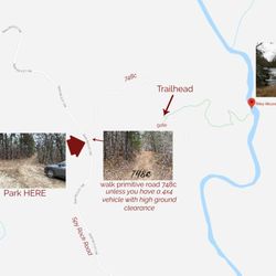
    I just wanted to update my 3/15/20 review below to add I've now done this hike several times, but…read moreTHIS time I had the chance to hike it with a friend who is directly related to the namesake of the waterfall... Riley Moore. Sandie is a church friend of mine and Riley Moore was her Great Great Uncle (I believe that's right). He once upon a time operated a grist mill here at the top of the falls. She's been trying to get here to see the waterfall, but couldn't find it and wanted to join us (along with her family) since I knew the way. Upon further research I discovered there are actually still remnants of the mill including visible drill holes, spikes and bolts. Thought that was pretty cool info to share! [ [ [ PREVIOUS REVIEW ] ] ] Riley Moore Falls is small in height but HUGE in personality. It's located off State Road S37-748, which is a nicely maintained gravel road where cars and trucks alike can comfortably traverse. ~~~ DIRECTIONS From Westminster, SC - DO NOT turn onto Cobb Bridge Road from Long Creek Hwy (Hwy 76) where you will see the brown & white sign pointing you in the direction of Riley Moore Falls. Our GPS had us go this way, then left onto State Road S37-748, but the road was CLOSED during our visit! INSTEAD, turn onto PU-32 also known as Rocky Fork Road. Turn left onto a gravel road near Rocky Fork Baptist Church and follow that until it dead ends @ State Road S37-748 (also known as Spy Rock Road). Turn right and drive approx. 1.4 miles (4 minutes) to 748c (aka Riley Moore Shoals Road). Park at the intersection of State Road S37-748 and 748c. DO NOT ATTEMPT TO DRIVE 748c in a car or minivan. Low clearance vehicles will find the terrain on this road to be VERY difficult to navigate without bottoming out or getting stuck. I'd also recommend 4x4 capability on wet days! There can be several deep-pocketed muddy areas after heavy rains. ~~~ THE TRAIL Once you reach the intersection of Spy Rock Rd (S37-748) and 748c, park roadside on Spy Rock, secure your vehicle and begin your hike approx. 1/2 mile down the "primitive road." IF you have a high ground clearance SUV or truck, you can drive the primitive road another half mile or so to a second parking area near the trailhead. The primitive road is VERY BUMPY  and can be muddy in spots after heavy rains, so a 4x4 is best. After reaching the second parking area, follow the marked trail on the left!!! The trail is a little over a 1/2 mile to the falls from here. The trail is fairly straightforward and easy to follow. ~~~ THE FALLS Once you reach the Chauga River, you will notice a large sandy area with plenty of room for an entire horde of hikers!!! Riley Moore Falls is not very tall (only about 12 feet), but it is very wide and has a deep base pool. PRO TIP - Bring swimwear, towels and a picnic, but be sure to pack it in and pack it out. ~~~ THINGS TO KNOW Hiking Distance: 2 miles (round trip to falls from S37-748) Difficulty of hiking 748c: All downhill to trailhead (moderate return) Difficulty of hiking trail to falls: EASY Creek Crossings: NO Elevation Gain: 357 feet Waterfall Height: Approx 12 feet Access to top of falls: NO - not without getting wet Access to base of falls: YES Pool of water @ base of Falls: YES Sitting areas @ base: YES + sandy beach RESTROOMS: NO PARKING: YES (along road) + secondary parking area closer to trailhead for trucks and high ground clearance vehicles with room for about 6 cars. ~~~ [ FINAL THOUGHTS ] A lovely waterfall in any season, but also a great spot for a summer swim. While we had the waterfall practically to ourselves during our Mid-March expedition, be advised other trail website reviews say it gets trashy & crowded in summer months. What a shame if that is true because it truly is a treasure. ENJOY! 2022 / 74 #UPDATE 178

    Don't know haven't been yet. I cannot tell you something why I have not been seen. So I cannot say…read moreanything about the place

    Photos
    Riley Moore Falls
    Riley Moore Falls - CREATED FROM GOOGLE MAPS

    CREATED FROM GOOGLE MAPS

    Riley Moore Falls

    See all

    Maxie Duke Falls

    Maxie Duke Falls

    5.0(1 review)
    6.0 mi

    Maxie Lee Wright Duke was an avid waterfall hunter and good friend to Sidney Holmes Ballenger, Jr.,…read morea man who loved waterfalls so much that he literally wrote the pioneering book on finding them in Oconee County, South Carolina. When he died @ age 73, Maxie wanted to honor him by petitioning the U. S. Department of the Interior in hopes of naming an UNNAMED local waterfall in his honor. While her 1993 petition was denied, the effort didn't end. In late 2014, Renee Hattenstein reapplied to the U.S. Board on Geographic Names to have the falls officially named Sid's Falls and in April of 2016, the name Sid's Falls was accepted by the board. Sadly I found an online obituary stating Maxie Lee Wright Duke passed away in December of 2020. But Oconee County residence wanted to honor her by unofficially naming a waterfall after her in close proximity to Sid's Falls. As a matter of fact, Maxie Duke Falls shares most of the same trail and parking that you would use to visit Sid's Falls. [ THE EXPERIENCE ] I WANT TO GIVE FAIR WARNING right up front that while 95% of this trail is super easy, the final leg of the trail to the base of the falls is NOT FOR THE FAINT OF HEART or anyone not capable of using BOTH HANDS during the descent. You will absolutely need to posses basic skills in climbing and some upper body and leg strength. The trail to the bottom at minimum fits the CLASS 3 hike rating and the breakoff trail to Maxie Duke is practically CLASS 4 as ropes are available to assist climbers on the steep, steep terrain. PARK at the small area off Damascus Church Road between Damascus Baptist Church and Cool Springs Road (State Route S-37-797). Walk around the gate and enjoy approx. 1.4 miles of easy hiking on a wide old road that passes two open grassy fields along the way. The grade varies, but typically stays within a 5% differential. However, once the trail enters into the woods and narrows, it becomes steeper. You will reach a point where the trail forks right or left. RIGHT is to Sid's Falls and LEFT is to Maxie Duke Falls. Here is where either trail gets noticeable difficult as the grade to Sid's can exceed -34% (according to AllTrails). Maxie Duke's trail is even steeper and may require the assistance of a preinstalled rope for most of the descent. Once you reach the creek you will need to wet cross over to the right side in order to achieve the best view of the falls. I ducked under a large fallen tree and discovered a dry trail leading to the base of the falls. I walked right out onto the stone ledge of the falls through the water and did not find the stones to be particularly slippery. In fact, I had good grip but I still remained very cautious. [ FINAL THOUGHTS ] When returning, you could also continue your adventure and follow the trail right of the split to Sid's Falls. But again, BE FOREWARNED the trail to Sid's is only slightly less steep, and you will absolutely need both hands and a lower center of gravity to remain balanced! Plan on getting your feet wet @ both falls to attain the best vantage for photos. Proceed with caution, respect the power of nature and know your own ability. It took us about 2 hours 20 minutes to hike from parking to both falls and back, which included rests and about 25 minutes of picture taking. ~ Round trip length to both: 3.3 miles ~ Elevation Gain: UNKNOWN (but probably 600+ feet) OVERALL this is a wonderful hike that will fool you into thinking it's easy for its majority... But do not choose to visit this trail casually! You're gonna get dirty, you're gonna be very tired, but the payoff is well worth the effort to see these two 50 foot beauties! NOT RECOMMENDED for young children, dogs, anyone with balance issues or solo hikers because it is not a popular trail (yet) and injuring yourself would make the return ascent very difficult. 2022 / 73

    Photos
    Maxie Duke Falls
    Maxie Duke Falls
    Maxie Duke Falls

    See all

    Brasstown Falls

    Brasstown Falls

    4.8(4 reviews)
    7.6 mi

    This was well-worth the drive from Columbia, SC. The hike wasn't that long. There were some stairs…read morethat were pretty steep but hand rails were available. Absolutely Stunning views.

    Beautiful waterfalls for just a short hike** from the parking lot. Has 3 sections,…read moreCascades/Veil/Sluice, the Cascades is the first one to get to and the easiest. The Veil section is probably my favorite part, it's a picture I see when someone mentions "waterfalls". I didn't hike down to the Sluice section as it didn't seem worth the effort after seeing the Cascades and Veil sections. ** excerpt from Richard R's amazingly detailed review and great tips "The hike is short to the first section of the falls known as "The Cascades." This is a highly appropriate name since this section really is more of a series of cascades than a waterfall. On the day of my visit, there had been several days of rain making the trail extremely muddy, but also making the falls extremely full! The flow was so strong that it was hard to see where the Cascades separated from the second section known as The Veil. You reach 'The Cascades' by following the trail on the right after the information board. You will go uphill slightly before making your descent down to the cascades. You will hear the falls long before you reach them. The downhill trail to the cascades is relatively easy, but it gets far more difficult when you continue downhill to see the two lower sections. NOTES: This is a class three hike, meaning you will need both hands to navigate the steepness of the trail. I HIGHLY RECOMMEND good hiking boots and a backpack for any camera, phone or other items you might carry in your hand. You will definitely need both hands to hold on to branches, tree roots or whatever you can find. * SCOUTING TIP - It is better to take the higher routes as you navigate your way to the lower falls. * SCOUTING TIP 2 - This trail IS NOT suitable for young children or anyone who doesn't have sure balance. Your legs, knees and upper body will be heavily used! * SCOUTING TIP 3 - DO NOT bring a walking stick. Again, you will need both hands to navigate this trail safely. I personally did not see the advantage to hiking down to the base of the second section known as 'The Veil'. However, if you are feeling adventurous, you can actually walk behind this section of the falls on low flow days. The trickiest part of the trail is finding your way to the base of 'The Sluice' section. At first I considered forgoing the hike since it was rather steep, but another hiker on his way up showed me pics on his camera that convinced me to continue. There is also a downed log you can use as a bridge to balance across to the other side for an even closer view of this third section of the falls, which looks a lot like a powerful water slide." https://www.yelp.com/biz/brasstown-falls-long-creek?hrid=Weq_6ZUYbqLd0Ao6QafbDg&utm_campaign=www_review_share_popup&utm_medium=copy_link&utm_source=(direct)

    Photos
    Brasstown Falls
    Brasstown Falls - Waterfalls

    Waterfalls

    Brasstown Falls

    See all

    Secret Falls

    Secret Falls

    5.0(3 reviews)
    13.7 mi

    Wanna know a secret???…read more There are waterfalls all over this region of the South just waiting to be discovered. Many are known and many more are unknown. While I've been hiking this area for nearly a decade, I only recently heard about this waterfall for the first time last year (2019). A well kept local secret indeed... but y'all dun let the wrong yelper discover this waterfall and the secret is about to be let out! [ THE DRIVE ] There are a shocking amount of natural waterfalls located on private property throughout this area. Thankfully this is not one of them and it can be enjoyed by all. The gravel road to the trailhead is known as Big Creek Road. Since we were coming from the King Creek Waterfall area near Tamassee SC, GPS lead us to the eastern end of Horse Cove Road, which is also known as Bull Pen Road closer to the Chattooga River (where you pass over a cool old iron bridge). I tell you these details because if you happen to follow our driving route on a week after heavy rainfalls, you are likely to see a great number of unnamed waterfalls off in the woods. We counted 5, and only one of them was a named waterfall on Google maps (Scotsman Falls). [ THE EXPERIENCE ] We traveled along Walking Stick Road until it took a sharp right turn towards Big Creek Road. On the day we visited, there was a locked gate blocking the drive onto Big Creek Road, so we parked in a small little niche near the gate and walked about 200 yards to the Secret Falls trailhead (which is marked with a narrow sign). The trail was very muddy, but the descent was slow and steady for the majority of the half mile hike. However, it gets considerably steeper as you approach the portion of the trail leading to the base of the falls. Here you will see poorly maintained wooden timbers actings as steps.They were so poor in fact, that we opted not to use them and walked alongside them. The waterfall was raging from all the recent rain, which limited some of our photo opportunities. It is a gorgeous waterfall with picturesque cascades both above and below it. The cascades below comes as the river takes a sharp left turn just past the pool of water at the base of the falls. Accessing the upper waterfall area is easily done by using a small obvious trail off to the left just before the wooden steps. A downed tree forces you to scramble over it and around large rhododendrons that are bent over from the weight of the fallen tree. Once through the brush, you will be directly on top of the falls, so be careful and exercise good judgement. [ THINGS TO KNOW ] Hiking Distance: 1.3 miles Difficulty: Easy and family friendly (but can be muddy) Creek Crossings: YES (3) Elevation Gain: 255 feet Waterfall Height: Approx 45 feet Access to top of falls: YES Access to base of falls: YES Pool of water @ base of Falls: YES Sitting areas @ base: YES RESTROOMS: NO PARKING: YES if gate is open. [ FINAL THOUGHTS ] THE SECRET IS OUT!!! This is a great waterfall for an easy family adventure. We came in the winter, but seems this would be a great picnic spot where kids could play in the water for hours in the summer. The drive to nearby Highlands, NC is only about 6.5 miles away for plenty of food options and even more waterfall adventures. Near Highlands are a number of GREAT waterfalls with very short hiking distances including Ranger Falls, Bust Yer Butt Falls, Bridal Veil Falls, Cullasaja River Falls and our personal favorites: Glen Falls, Dry Falls, Mud Falls and Estatoah Falls (which is hidden just next to the Sky Valley Scenic Overlook). ENJOY!!! 2020 / 4

    I was somewhat surprised that there are not more reviews of this trail/waterfall. I believe that…read morethe real name of this falls is Big Shoals Falls. In his book on NC waterfalls, Kevin Adams referred to it as Secret Falls and the name seems to have stuck. For years, there was no official trail to this waterfall and the one unofficial trail which existed traversed private property. I've been visiting the area for thirty years and this (October 2021) was my first visit to this waterfall. Bottom line: It is awesome. Truly one of the more beautiful waterfalls that I've been to. I have to disagree with the previous reviewer: IMO, this trail is in horrible shape. Granted, reviews like these are entirely subjective. But I would definitely not bring young children or dogs here. When I visited, the trail was really in bad shape. The first part of the hike was fairly easy. But the farther you go, the worse the trail becomes. Erosion had taken a terrible toll. There are many rutted and washed-out areas. Some were so bad that hikers have bypassed the trail completely. The final descent to the base of the falls was the worst. Wooden steps had been constructed. But the erosion was so bad that much of the soil behind the steps had washed out making the steps all but unusable. There are two water crossings on the trail. One was a couple of planks stretched across a small branch. The other was on a split log over a somewhat larger stream. Neither was too difficult. Then again, the faint-of-heart would probably not care for either one. Trekking poles helped me on both. I was not able to find a path to the brink of the falls. I tried one crude path which seemed to be incredibly choked with rhododenron. So I gave up on getting to the top of the falls. There is a much smaller cascade downstream of the main falls. As with the brink, I could not figure out how to get to it. I visited early in the morning and had the place all to myself. The lighting wasn't terrific. I'm not sure what time or sky conditions are ideal for photography. I drove in on Rich Gap and Big Creek Roads off of Hwy 28 south of Highlands. It wasn't too bad of a drive in my 2WD F-150. But I believe that the drive out on Walking Stick Rd to Horse Cove Rd east of town was easier. If you love waterfalls, definitely put this one on your must-see list. But be aware of the fact that the hike is a challenge. Not so much due to elevation change (which is moderate) but, rather, due to the overall condition of the trail.

    Photos
    Secret Falls - Have to walk over this water

    Have to walk over this water

    Secret Falls - Cross the tree

    Cross the tree

    Secret Falls

    See all

    Martin Creek Falls - Base of Martin Creek Falls approximate height here is about 15 to 18 feet of the overall 30 feet height of the entire falls.

    Martin Creek Falls

    4.7(3 reviews)
    7.2 mi

    Beautiful waterfalls and very easy to get to from warwoman dell parking lot. The trail is abt 2…read moremiles one way with an easy water crossing within 5 min. You can avoid it if you take the trail on the right of road crossing instead of going straight. The path is mostly gentle and downhill to falls but it felt ssteep and uphill on our way back from pinnacle knob at the end of 8 Miles. Always an awesome hike especially after rain or with fall colors

    Martin Creek Falls is a beautiful secluded waterfall in Clayton, GA near Warwoman Dell. It is part…read moreof the Chattahoochee National Forest that encompasses the entire Northeast corner of the state of Georgia. The forest itself is 750,145 acres and is so large that it is divided into regions. Martin Creek is located in the Chattooga River District and specifically in Rabun County, whom incorporates the largest portion of the National Forest. 148,684 acres of this massive forest system lie within Rabun County borders. Depending on how much you like hiking, you can get to Martin Creek Falls on a short 1/2 mile hike via Finney Creek Road or a longer 2 mile hike (one way) from Warwoman Dell via the Bartram Trail. If you choose to hike from Warwoman Dell, your extra effort will be rewarded with two additional waterfalls as well as a loop trail highlighting the history of the area. Becky Branch Falls is located near the trailhead at Warwoman Dell and an additional unnamed waterfall is about 1/4 mile south of Martin Creek Falls. Only about 8 feet tall, but it's multiple levels make it a beauty. Martin Creek Falls is one of the prettier waterfalls in North Georgia. It is a multi-tiered waterfall that looks as if it goes on forever from the base. It is also one of the few waterfalls that I wish the vegetation would be cut away to make the full view of the falls visible. From the deck at its base you can see the largest drop, but the upper tiers become more difficult to see as vegetation near the middle tier blocks the view. Still, it is a gorgeous waterfall that makes wandering in this neck of the woods an incredibly satisfying adventure. The lower part of the falls are shaded while the upper part is sunny, so bring a UV filter (which I forgot) for best DSLR results. DIRECTIONS From US-23 (Hwy 441) in Clayton, Georgia travel east on Rickman Road. In 1/2 a mile it will merge into Warwoman Road. 2.5 miles from here you will pass the parking entrance to Warwoman Dell, which is difficult to see, but look for a small brown sign with a picnic table symbol and turn right. You can either park here and take Bartram Trail to the falls (about 2 miles one way) OR continue along Warwoman Road to Finney Creek Road. Approximate address for Finney Creek Road is 3742 Warwoman Rd, Clayton, GA 30525. TURN LEFT. It is a gravel road across from an open grassy field. The trailhead to the falls is approximately 1.1 miles from Warwoman Road or approximately 1/2 mile from the Wildlife Management Check-In station that you will pass along Finney Creek Road. Hike from this trailhead to the falls is approximately 1/2 mile round trip. Recommended for families with young children as they can also splash around in the pool of water at the waterfalls base, so bring their swimsuits and ENJOY! 2018/54

    Photos
    Martin Creek Falls - The bridge to the viewing deck

    The bridge to the viewing deck

    Martin Creek Falls - The viewing deck

    The viewing deck

    Martin Creek Falls - The cascading stream heading downhill.

    See all

    The cascading stream heading downhill.

    Fall Creek Falls Trailhead - hiking - Updated July 2026

    Loading...
    Loading...
    Loading...