Finley Hills Trails Photos


You might also consider
More like Finley Hills Trails
Recommended Reviews - Finley Hills Trails
Start your review...

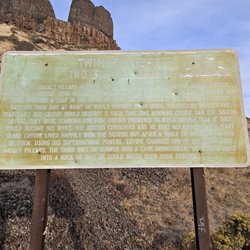
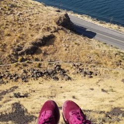
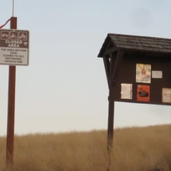
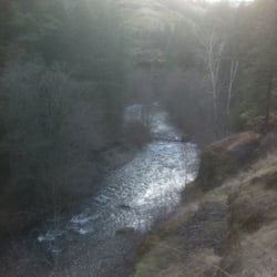
Nestled within the elbow of the mighty Columbia as it makes its last dash Pacific-ward are the Finley Hills Trails. This area is known as the Wallula Gap & you are gifted with views of this natural wonder....after you ride through some sandy, desolate, and sweat-inducing trails (that can sometimes have a rattler or few). So, I have looked at this area from afar (by car when heading down to Walla Walla, or by train window when going to Portland), and have always loved the terrain. Here, the Columbia cuts through what must have once day been a mountain, and now we're left with a mini-canyon with high walls. I always assumed the views from atop these walls must be awesome, and they are. Getting here is a short jaunt from the Tri-Cities, and yes, you do drive through Finley (it's not that scary, actually). Most of the drive is paved save for the last mile. There's an area to park your car (it isn't marked, but the Yelp Map should give ya a good idea). Once parked, cross the road you were just on and make your way through the gate/fence. Then you're in. There's the main road/trail here. I heard there is atleast one single track you can also take here if you take an immediate left, but it wasn't illuminated to me (grasses overtook it methinks). At any rate, just follow the road. The riding is decent, but it does get sandy in parts. If it's windy (which is frequently on the menu at the Wallula Gap), you will wish you had a mask like Darth Vader. I rode a few miles and saw no other bikers, but did see people on horseback. I was frequently on the lookout for rattlesnakes. It was a hot day, and my friend mentioned they also like this area (I never came across a single one). After a tough arduous workout, I spied some sort of Tower (probably cellular) and made my way toward it. Here is reward for all the pain and suffering. This is a perch with the views to make memories. Here you can see Mr. Columbia's elbow. You're going to be high up along cliff's so don't be too daring. It's a bit rocky here, too, so mind your knees and don't do the falling thing. This is what made it all worth it. Great views, great views, great views. Next time, I'd probably try this during a less windy and earlier in the season (to avoid the dryness factor). But all in all, a new local biking option has been found. read more


More info about Finley Hills Trails
Finley, WA 99337
Directions
Hours
Outdoor Amenities


Finley Hills Trails - hiking - Updated July 2026
Best of Finley
People found Finley Hills Trails by searching for…
Trending Searches in Finley, WA
Browse Articles
Browse Nearby
BEST of Finley, Washington Parks near Finley Hills Trails
BEST of Finley, Washington Restaurants near Finley Hills Trails
BEST of Finley, Washington Things to Do near Finley Hills Trails
BEST of Finley, Washington Coffee near Finley Hills Trails
BEST of Finley, Washington Horseback Riding near Finley Hills Trails
BEST of Finley, Washington Breakfast near Finley Hills Trails
BEST of Finley, Washington Campgrounds near Finley Hills Trails
Browse Brands
Related Searches in Finley, WA
Affordable Bike Repair Services in Finley, Washington
Affordable Bike Tune Up Services in Finley, Washington
Best Dog Hiking Trails Around Finley, Washington
Best Lookout Points to Visit in Finley, Washington
Best Nature Trails for Hiking in Finley, Washington
Best Places for Horseback Riding in Finley, Washington
Best Places for Stunning Views in Finley, Washington
Best Spots for Star Gazing in Finley, Washington
Best Waterfalls and Swimming Holes in Finley, Washington
Check Out Off Road Trails in Finley, Washington
Discover Lakes & Ponds to Explore in Finley, Washington
Discover Popular Bike Trails in Finley, Washington
Discover Popular Photo Spots in Finley, Washington
Discover Scenic Mountain Bike Trails Near Finley, Washington
Discover Top Nature Parks to Visit in Finley, Washington
Discover a Hiking Trail in Finley, Washington
Discover the Best Fishing Lake in Finley, Washington
Discover the Best Night Hike Trails in Finley, Washington
Dog-Friendly Hikes With Dogs in Finley, Washington
Enjoy Camping Adventures Around Finley, Washington
Enjoy Exciting Mountain Biking Adventures in Finley, Washington
Enjoy Hiking Adventures in Finley, Washington
Enjoy Off Leash Dog Hikes in Finley, Washington
Enjoy Scenic Night View Experiences in Finley, Washington
Enjoy Tent Camping Spots Around Finley, Washington
Enjoy the Best Night View Spots in Finley, Washington
Enjoy the Best Picnic Spots and Ideas in Finley, Washington
Enjoy the Best Walking Trails in Finley, Washington
Experience Stunning Sunset Views in Finley, Washington
Explore Beautiful Parks and Green Spaces in Finley, Washington
Explore Electric Bikes Available in Finley, Washington
Explore Popular Campgrounds Near Finley, Washington
Explore Popular RV Parks Around Finley, Washington
Explore Popular Scenic Overlook Points in Finley, Washington
Explore Popular Scenic Views Near Finley, Washington
Explore Popular View Points Around Finley, Washington
Explore Scenic Lakes to Visit in Finley, Washington
Family Friendly Hiking With Kids in Finley, Washington
Find Beautiful Views in Finley, Washington
Find Fun Kids Activities Outdoor in Finley, Washington
Find Parks and Recreation Activities in Finley, Washington
Find Specialized Bikes and Accessories in Finley, Washington
Find Top Dog Swimming Spots in Finley, Washington
Find Top-Rated Waterfalls in Finley, Washington Now
Find the Best Parks for Picnics in Finley, Washington
Find the Best Scenic View Locations in Finley, Washington
Get Reliable Bike Tire Repair in Finley, Washington
Off Leash Dog Hiking Trails in Finley, Washington


