Rattlesnake Slope Trail Photos


More like Rattlesnake Slope Trail
Recommended Reviews - Rattlesnake Slope Trail
Start your review...

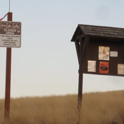
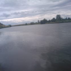
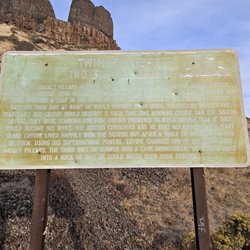
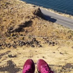
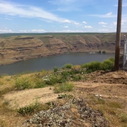
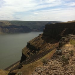
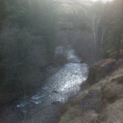
When people ask about things to do in the Tri-Cities, I usually say, "you have to drive an hour or two to find somewhere cool." (This was because I was lazy). I think one can find ANYTHING unique and cool WHEREVER they live. So, I've been trying to open my eyes to local options. Rattlesnake Mountain is said to the be the "highest mountain west of the Mississippi WITHOUT a tree on it". I don't know about that lofty claim, but that's its claim to fame. Rattlesnake Mountain ("Lalíik" name of mountain in Wanapum) always seemed elusive. Part of it is owned by a farmer (I on the western slope), while the eastern slope is under control of the Arid Lands Ecological Reserve. This is a huge ridge and the southern part of the ridge is where one can find hiking options. Right off of SR225, one can find a few trailheads. So, if you're traveling from SR240, go past the shooting range and then keep an eye out for a couple of trailheads to your left (if you're coming from Benton City, as soon as you pass the last house, the two trailheads will be on your left. The big trailhead is hard to miss and has a big sign marking itself. This is where some people unload their horses for rides up the Rattlesnake Slope. The other trailhead (a little more west) is small, and can fit only about 3 vehicles. Both trailheads have trails which head up the Slope. They join within a few minutes of traveling north. Once the trails are joined one then hikes up a canyon. The trail is basically a rutted road (perhaps access road for the powerlines you walk under while hiking). The hike in the canyon is nice and somewhat protected from the elements. Keep an eye out for wildlife. There are deer, coyotes, and elusive elk among the local inhabitants. Once you pop up out of the canyon you are in the grassy sage steppe of southeastern Washington. You can see the breath-taking expanse of land leading up to Rattle Mountain---"wow, the Tri-Cities is nearby??" One has a couple of options now. One can continue to hike on the main trail--this goes onto the flatlands below Rattlesnake Mountain, or one can take the less tread path which goes up to Rattlesnake Ridge (basically you walk along a barbed wire fence. We went up. This isn't for the weary. The hike is fairly vertical, and climbs up fast, but what a view. One can see LIGO (http://www.yelp.com/biz/ligo-hanford-observatory-richland), most of the Hanford Reservation, and quite a bit of the Tri-Cities and other nearby & smaller mountains (such as Badger {http://www.yelp.com/biz/badger-mountain-trails-richland}). All in all this is nice walk with great views. A good option for "something to do in the Tri-Cities". read more


More info about Rattlesnake Slope Trail


Rattlesnake Slope Trail - hiking - Updated July 2026
Best of Benton City
People found Rattlesnake Slope Trail by searching for…
Things to Do in Benton City, Washington
Hiking Trails in Benton City, Washington
View Points in Benton City, Washington
Off Road Trails in Benton City, Washington
Places to Take Pictures in Benton City, Washington
Walking Trails in Benton City, Washington
Sunset View in Benton City, Washington
Star Gazing in Benton City, Washington
Tent Camping in Benton City, Washington
Beautiful Views in Benton City, Washington
Sunrise View in Benton City, Washington
Attractions in Benton City, Washington
Running Trails in Benton City, Washington
Swimming Lakes in Benton City, Washington
Rattlesnake in Benton City, Washington
Views in Benton City, Washington
Secret Spots in Benton City, Washington
Natural Hot Springs in Benton City, Washington
River Swimming in Benton City, Washington
Free Campgrounds in Benton City, Washington
Secluded Spots in Benton City, Washington
Bike Paths in Benton City, Washington
Trending Searches in Benton City, WA
Boat Rental in Benton City, WA
Fruit Picking in Benton City, WA
Kayak Rental in Benton City, WA
Off Road Trails in Benton City, WA
Outdoor Activities in Benton City, WA
Places To Swim in Benton City, WA
Public Pools in Benton City, WA
Public Shower in Benton City, WA
River Swimming in Benton City, WA
Running Trails in Benton City, WA
Swimming Holes in Benton City, WA
Browse Articles
Browse Brands
Related Searches in Benton City, WA
Best Fishing Locations and Guides in Benton City, Washington
Best Fun Things to Do in Benton City, Washington
Best Nature Trails for Hiking in Benton City, Washington
Best Places for Horseback Riding in Benton City, Washington
Best Places for Stunning Views in Benton City, Washington
Best Spots for Star Gazing in Benton City, Washington
Best Waterfalls and Swimming Holes in Benton City, Washington
Check Out Off Road Trails in Benton City, Washington
Discover Popular Bike Trails in Benton City, Washington
Discover Scenic Mountain Bike Trails Near Benton City, Washington
Discover Scenic Waterfall Spots in Benton City, Washington
Discover a Hiking Trail in Benton City, Washington
Discover the Best Running Track in Benton City, Washington
Dog-Friendly Hikes With Dogs in Benton City, Washington
Enjoy Camping Adventures Around Benton City, Washington
Enjoy Exciting Mountain Biking Adventures in Benton City, Washington
Enjoy Tent Camping Spots Around Benton City, Washington
Enjoy Water Activities and Fun in Benton City, Washington
Enjoy the Best Night View Spots in Benton City, Washington
Enjoy the Best Picnic Spots and Ideas in Benton City, Washington
Enjoy the Best Walking Trails in Benton City, Washington
Explore Beautiful Parks and Green Spaces in Benton City, Washington
Explore Nature Spots Around Benton City, Washington
Explore Popular Boat Charters Near Benton City, Washington
Explore Popular Campgrounds Near Benton City, Washington
Explore Popular RV Parks Around Benton City, Washington
Explore Popular Scenic Overlook Points in Benton City, Washington
Explore Popular View Points Around Benton City, Washington
Explore Top Dog Parks in Benton City, Washington Near You
Explore Top Water Parks in Benton City, Washington Today
Explore the Best Trail Options in Benton City, Washington
Family Friendly Hiking With Kids in Benton City, Washington
Find Beautiful Views in Benton City, Washington
Find Cozy Camping Cabins in Benton City, Washington
Find Fun Kids Activities Outdoor in Benton City, Washington
Find Fun Things to Do With Kids in Benton City, Washington
Find the Best Scenic View Locations in Benton City, Washington
Find the Best Swimming Pools in Benton City, Washington Today
Have Fun at a Splash Pad in Benton City, Washington
Off Leash Dog Hiking Trails in Benton City, Washington
Perfect Spots to Watch Sunset in Benton City, Washington
Plan a Scenic Drive Route Near Benton City, Washington
Popular Kids Activities in Benton City, Washington
Popular Places to Take Pictures in Benton City, Washington
Popular Things to Do in Benton City, Washington
Safe River Swimming Areas in Benton City, Washington
Top Playgrounds for Kids to Enjoy in Benton City, Washington
Top Running Trails to Explore in Benton City, Washington
Top-Rated Basketball Courts to Play at in Benton City, Washington