Granny Squirrel Covered Bridge Photos


More like Granny Squirrel Covered Bridge
Recommended Reviews - Granny Squirrel Covered Bridge
Start your review...

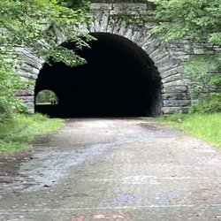
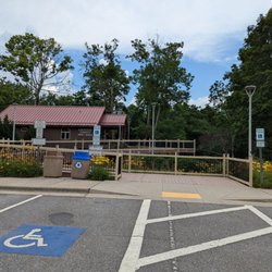
The Granny Squirrel Covered Bridge has a name that sounds like it wandered out of a tall tale and honestly that might be the most dramatic thing about it because despite the folksy title, it isn't really a bridge at all. It's more like a short decorative walkway tucked into the roadside with a roof that gives it the vibe of a covered bridge without actually carrying anything over water. But the quirky name and the quiet little setting make it one of those stops that's fun precisely because it feels a bit odd and a bit charming at the same time. [Round number review 25700 overall - 518 of 2026 - 4613 in North Carolina] read more


More info about Granny Squirrel Covered Bridge


Granny Squirrel Covered Bridge - landmarks - Updated June 2026
Best of Andrews
People found Granny Squirrel Covered Bridge by searching for…
Trending Searches in Andrews, NC
Boat Rental near Granny Squirrel Covered Bridge
Caves near Granny Squirrel Covered Bridge
Cliff Jumping near Granny Squirrel Covered Bridge
Day Trips near Granny Squirrel Covered Bridge
Dog Friendly Beaches near Granny Squirrel Covered Bridge
Fishing Spots near Granny Squirrel Covered Bridge
Historical Sites near Granny Squirrel Covered Bridge
Jet Ski Rental near Granny Squirrel Covered Bridge
Landmarks & Historical Buildings near Granny Squirrel Covered Bridge
Lookout Points near Granny Squirrel Covered Bridge
Peach Picking near Granny Squirrel Covered Bridge
Pick Your Own Farms near Granny Squirrel Covered Bridge
Places To Swim near Granny Squirrel Covered Bridge
River Swimming near Granny Squirrel Covered Bridge
Scenic Restaurants near Granny Squirrel Covered Bridge
Splash Pad near Granny Squirrel Covered Bridge
Strawberry Picking near Granny Squirrel Covered Bridge
Swimming Holes near Granny Squirrel Covered Bridge
Swimming Lakes near Granny Squirrel Covered Bridge
Things To See near Granny Squirrel Covered Bridge
Browse Articles
Browse Nearby
Browse Brands
Related Searches in Andrews, NC
Best Fishing Locations and Guides in Andrews, North Carolina
Best Fun Things to Do in Andrews, North Carolina
Best Lookout Points to Visit in Andrews, North Carolina
Best Observation Deck Views in Andrews, North Carolina
Best Spots for Star Gazing in Andrews, North Carolina
Best Things to Do on a Rainy Day in Andrews, North Carolina
Best Waterfalls and Swimming Holes in Andrews, North Carolina
Discover Charming Historic Homes in Andrews, North Carolina
Discover Family-Friendly Aquariums in Andrews, North Carolina
Discover Famous Monuments in Andrews, North Carolina
Discover Fun Kid Activities to Enjoy in Andrews, North Carolina
Discover Popular Photo Spots in Andrews, North Carolina
Discover Stunning Skyline View Spots in Andrews, North Carolina
Discover the Best Beaches in Andrews, North Carolina
Discover the Best Caves to Explore in Andrews, North Carolina
Discover the Best Planetarium Shows in Andrews, North Carolina
Enjoy Arts & Entertainment in Andrews, North Carolina
Enjoy Hiking Adventures in Andrews, North Carolina
Experience Stunning Sunset Views in Andrews, North Carolina
Explore Beautiful Botanical Gardens in Andrews, North Carolina
Explore Beautiful Castles and Landmarks in Andrews, North Carolina
Explore Beautiful Parks and Green Spaces in Andrews, North Carolina
Explore Family-Friendly Zoos and Wildlife in Andrews, North Carolina
Explore Free Things to Do Around Andrews, North Carolina
Explore Fun Activities to Do in Andrews, North Carolina
Explore Fun Field Trips in Andrews, North Carolina
Explore Popular Scenic Overlook Points in Andrews, North Carolina
Explore Popular Scenic Views Near Andrews, North Carolina
Explore Scenic Lakes to Visit in Andrews, North Carolina
Explore Secret Spots Worth Visiting in Andrews, North Carolina
Explore Venues & Event Spaces in Andrews, North Carolina
Find Exciting Tours to Take in Andrews, North Carolina
Find Top Libraries to Visit in Andrews, North Carolina
Find Top-Rated Waterfalls in Andrews, North Carolina Now
Find the Best Bridge Spots in Andrews, North Carolina
Find the Best Playgrounds to Visit in Andrews, North Carolina
Fun Rainy Day Activities to Try in Andrews, North Carolina
Hiking Trails With Waterfalls in Andrews, North Carolina
Must-See Tourist Attractions Around Andrews, North Carolina
Perfect Spots to Watch Sunset in Andrews, North Carolina
Popular Kids Activities in Andrews, North Carolina
Popular Picnic Spots to Visit in Andrews, North Carolina
Popular Places to Take Pictures in Andrews, North Carolina
Popular Things to Do in Andrews, North Carolina
Secure Convenient Parking Options in Andrews, North Carolina
See Top Fireworks Events in Andrews, North Carolina
Top Entertainment Options in Andrews, North Carolina
Top Hiking Trails to Explore in Andrews, North Carolina
People who viewed Granny Squirrel Covered Bridge also viewed
Fort Butler
1 review
Swain County Heritage Museum
9 reviews
Fontana Dam
10 reviews
Fort Hembree Historical Marker
1 review
Junaluska Historical Marker
1 review
Swain County Courthouse
1 review
Tsali Historical Marker
1 review
Clay County Government Center
1 review
Hiwassee Dam
3 reviews
Telliquah Covered Bridge
1 review