Hells Canyon National Recreation Area Photos


More like Hells Canyon National Recreation Area
Recommended Reviews - Hells Canyon National Recreation Area
Start your review...

12 years ago
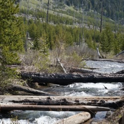
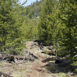
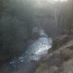
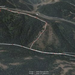
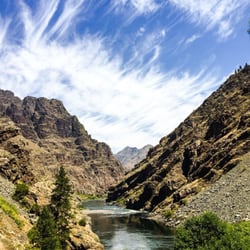
Hells Canyon is what you make of it. If you imagine it to be a gateway to hell, then that is exactly what it will be: grueling trails through rugged country, hostile heat and cold, intrusive plants and animals (poison ivy, ticks, rattlesnakes), and endlessly long and steep days followed by eternally long nights. If you approach it differently, with an open mind and an expansive heart, then Hells Canyon will be like the Iceland of the American West: beauty instead of brutality; green fields, verdant wildflowers, snow-topped ridges, and cascading mountain streams. Birds will sing and winds will blow; stars will shine brightly at night and you will stare in perpetual awe at one of America's most pristine wilderness areas. But the greater truth is that BOTH of these places exist - the Hells Canyon of nightmares, and the Hells Canyon of dreams. You simply have to find a way during your visit here to reconcile these opposing visions into an integrated whole. If you can do that - the beauty and and the beast coexisting happily together - then you will emerge from Hells Canyon a transformed person with a deeper sense of self and an enhanced appreciation for the diversity of the wider world in an appropriately sized package (750,000 acres, for starters). And if you can survive the ordeal, you will exit the canyon happier, heartier, and healthier than when you left - like Orpheus in the Underworld, except that in this particular case, you won't feel the need to look back. That, in essence, is what Hells Canyon means to me. And to you, if you are ready for the experience. May is the best of all possible months for visiting the canyon by foot or mule: you'll likely enter using Freezeout Trailhead (30 miles on asphalt and gravel roads from Joseph, OR), or Dug Bar, a long high-clearance road to the North (downstream). Bear in mind that the Idaho side of the canyon - the Seven Devils Wilderness - is still deep in melting snow, and is not accessible until the summer, so you'll need to enter from the Oregon side if you want to see the wildflowers and the impossibly green meadows that carpet the canyon in springtime. Plan for 3-5 days, choose the High Trail (#1751) as your main route, and don't descend to the Snake River unless you are prepared for thorns, poison ivy, and brush. Sluice Creek and Saddle Creek make good access points if you choose this path (Temperance Creek does not). If you are a first-time visitor, I'd recommend staying on the High Trail the whole time. Head up, down, and then North until you are tired, find a campsite, then return back over Freezeout Saddle when you have had your fill of what the canyon has to offer. The climb over Freezeout Saddle is epic: steep, switchbacked, with expansive views of the Seven Devils and of the distant Eagle Cap wilderness to the West. On a clear day, with lupines, Indian paintbrush, and arrowleaf balsamroot blooming, this is the most beautiful place you ever will see - as untouched and unvarnished a natural landscape as you are likely to find in the continental U.S. This is hard country. You need to be prepared. That "hell" part isn't a joke. But it's also America's grandest and most incredible canyon, end of story. If you are able to come, and it takes time, effort, and luck, then just do it! You'll emerge a different person than when you started, and that's something to treasure for years and decades to come. read more


More info about Hells Canyon National Recreation Area


Hells Canyon National Recreation Area - hiking - Updated June 2026
Best of Wallowa
Browse Brands
Related Searches in Wallowa, OR
Affordable Long Term RV Parking in Wallowa, Oregon
Best Things to Do on a Rainy Day in Wallowa, Oregon
Best Waterfalls and Swimming Holes in Wallowa, Oregon
Browse Top Hotels in Wallowa, Oregon for Your Stay
Enjoy Camping Adventures Around Wallowa, Oregon
Enjoy Tent Camping Spots Around Wallowa, Oregon
Explore Free Things to Do Around Wallowa, Oregon
Explore Hotels & Travel Options in Wallowa, Oregon
Explore Popular Campgrounds Near Wallowa, Oregon
Explore the Best Wineries in Wallowa, Oregon for Wine Tasting
Find Cozy Camping Cabins in Wallowa, Oregon
Must-See Tourist Attractions Around Wallowa, Oregon
Popular Things to Do in Wallowa, Oregon
Browse Articles
People found Hells Canyon National Recreation Area by searching for…
Natural Hot Springs in Wallowa, Oregon
Boat Repair in Wallowa, Oregon
Hiking Trails in Wallowa, Oregon
Attractions in Wallowa, Oregon
Beautiful Views in Wallowa, Oregon
Boat Rental in Wallowa, Oregon
Things to Do in Wallowa, Oregon
Fishing Trips in Wallowa, Oregon
Walking Trails in Wallowa, Oregon
Fishing Spots in Wallowa, Oregon
Lakes & Ponds in Wallowa, Oregon
Fishing Guides in Wallowa, Oregon
Places to Take Pictures in Wallowa, Oregon
Sunset View in Wallowa, Oregon