Hollenbeck Canyon Wildlife Area Photos


You might also consider
More like Hollenbeck Canyon Wildlife Area
Recommended Reviews - Hollenbeck Canyon Wildlife Area
Start your review...

Reviews With Photos

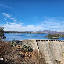
Was able to visit this hiking area during my Thanksgiving vacation, it was actually quite hot outside for November. The parking lot for this place is off Honey Springs road, which is right off the main drag of Campo rd. The trailhead has a few notices and a map showing you the canyon with the different paths for trails. The great thing about this canyon hike is the many different ways you can go around it. The pathways are very well maintained and and wide enough to bring your dog with you. This is excellent place to go mountain biking, as it provides lots of grades and hills but I wouldn't come here to run due to the uneven slippery trails some of the way up the canyon side. The trail has only a bit of shady area, so it does get really hot when out in the sun, for November I was cooking out here around noon time. Overall Hollenbeck is a decent trail system out in east county Jamul. You will be treated to lots of great views once going up the canyon hills. There is lots of nature out here along with plenty of peace and quiet since it's not near any major roads. The trail doesn't seem like it ever too busy really, as no one was even there when I came during the day with a friend. This one of the better state maintained wildlife areas in the San Diego county areas, they do a great job at keeping it clean. Great place to come walking with your dog or taking your bike out for a short run.

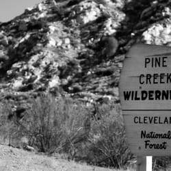
Beautiful place to hike! Good place to bring your kids and dogs. We went in the late afternoon, the temperature was perfect and there were only a couple of other people there. Beware though, if you're not hunting, you must purchase a "land use" pass. This is a new requirement and if you want to purchase the pass online you must buy it 15 days in advance I've attached pictures of the new sign.

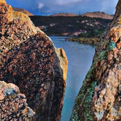
I love the mountain biking out here. There is a lot of climbing but most of it is on fire road and the payoff is SIIIIIIIIICK! There are two great segments of single track, mostly downhill but with short climbs in spots. One of the areas goes into a rocky canyon with a huge drop off and it is beautiful and super fun. I also see a lot of hikers out here. My advice would be to wear a lot of sunscreen have a lot of water with you. Even though there are groves of trees out here there are also huge expanses with no shade. Also, don't forget your camera !


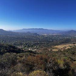
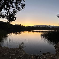
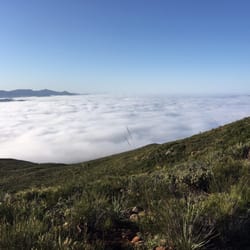
Hollenbeck Canyon consists of a neat network of nature trails that is off-the-beaten path, but certainly worth a look- especially during the month of March when spring is in full force and the trails are surrounded by the bright green spring-time folliage. There is a good 13-14 miles network of trails that one can follow and hike through. Regardless, you can make your time here as short or as long as you like. I actually mountain biked here during my visit in March 2012, but I saw plenty of hikers and equestrian folks as well. Take my advice and check out Hollenbeck Canyon! You'll be glad you did!

This place is gorgeous! I've lived in San Diego for more than 30 years and I'm NOW just discovering it! We started kind of late 9am so by the time we were heading back to the car, it was getting hot. I don't think I'd hike here in the summer, but the cooler months - definitely worth it.

Mountain bikers, hikers, runners and dogs, there is something for everyone here. Although the trails are well worn, they're not clearly marked. But, I'd assume they all loop somewhere. Too bad the drought dried up the creek. Be warned, there are large patches of meadows with no covering so even at 70 degrees the sun beats down like a drum.

This hike is a long and seemed like never ending hike through the canyons. Nice views and lots of options walking throughout the trails. The signs post or lack thereof, makes the hike a little confusing if you are not sure which path to take. I prefer more of a summit hike but you will definitely get a good workout doing this hike and will see horses next to the ranch. Plenty of parking and safe area as well. Plan for about 2-3 hours to see it all.

This was an enjoyable hike that is best to do in the morning. I came with my hubby and a friend who has done this hike numerous times. The lot has plenty of parking and not crowded at all for being a weekend. There is a porter potty (bring your own toilet paper and hand sanitizer) but no drinking facilities. I could see this hike being miserable on direct heat so do bring plenty of water. I drank about 48 oz on a relatively cool day (when we finished the hike it was 82 degrees). It took us just short of two hours (started at 8 am) to complete the loop. When you see the trail split we ventured to the right of the trail (you'll come back on the other side). After a nice relatively flat walk you'll start to ascend. This is the toughest part of the hike but it doesn't last long. Key is to go slow. The view from the top is fantastic and totally worth it. Then you'll descend and end up going through this abandoned corral. The scenery is very nice. Only a slight incline awaits you before it goes flat again and you branch off to the trail you've started. It's a very nice easy to moderate hike (moderate being the incline). Terrain can be slippery due to loose dirt, rocks, and gravel so wear shoes with good traction. Nice hike overall. I'd definitely do this again. My advice- come early to avoid the heat, bring plenty of water/snacks, shoes with traction, and hand sanitizer and toilet paper in case the toilet is not stocked. read more


5 years ago
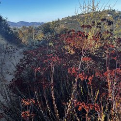
I haven't been out here for a while...Spring flowers are in bloom, everything was GREEN, water flowing! So beautiful! It was chilly early in the morning, but as you start to leave the valley, you'll feel a warm breeze coming off the mountain. As you ascend towards the mountain side you'll feel the sun beat down on you, so don't forget sunblock and plenty of water! There's plenty of shade down in the valley, but limited on the mountain. Get up and get out! read more


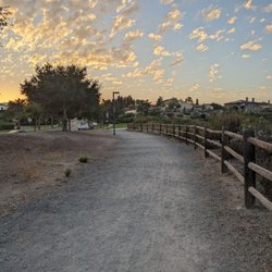
Hollenbeck canyon is a family friendly place to hike. The trails are easy to moderate and have plenty of shade if you go during the day. I prefer morning or late afternoon and I do recommend going while there is still running water in the creek. You have several options as far as hiking trails go so have fun and explore but definitely manage your time well if you go later in the afternoon. As always take plenty of water and stay hydrated!!! read more


Was able to visit this hiking area during my Thanksgiving vacation, it was actually quite hot outside for November. The parking lot for this place is off Honey Springs road, which is right off the main drag of Campo rd. The trailhead has a few notices and a map showing you the canyon with the different paths for trails. The great thing about this canyon hike is the many different ways you can go around it. The pathways are very well maintained and and wide enough to bring your dog with you. This is excellent place to go mountain biking, as it provides lots of grades and hills but I wouldn't come here to run due to the uneven slippery trails some of the way up the canyon side. The trail has only a bit of shady area, so it does get really hot when out in the sun, for November I was cooking out here around noon time. Overall Hollenbeck is a decent trail system out in east county Jamul. You will be treated to lots of great views once going up the canyon hills. There is lots of nature out here along with plenty of peace and quiet since it's not near any major roads. The trail doesn't seem like it ever too busy really, as no one was even there when I came during the day with a friend. This one of the better state maintained wildlife areas in the San Diego county areas, they do a great job at keeping it clean. Great place to come walking with your dog or taking your bike out for a short run. read more


8 years ago
Beautiful place to hike! Good place to bring your kids and dogs. We went in the late afternoon, the temperature was perfect and there were only a couple of other people there. Beware though, if you're not hunting, you must purchase a "land use" pass. This is a new requirement and if you want to purchase the pass online you must buy it 15 days in advance I've attached pictures of the new sign. read more


I love the mountain biking out here. There is a lot of climbing but most of it is on fire road and the payoff is SIIIIIIIIICK! There are two great segments of single track, mostly downhill but with short climbs in spots. One of the areas goes into a rocky canyon with a huge drop off and it is beautiful and super fun. I also see a lot of hikers out here. My advice would be to wear a lot of sunscreen have a lot of water with you. Even though there are groves of trees out here there are also huge expanses with no shade. Also, don't forget your camera ! read more


5 years ago
7 years ago
Such a serene and relaxing place to hike. I dislike that they imposed fees but there are less people on this trail unlike Cowles which is always packed. read more


6 years ago
14 years ago
Hollenbeck Canyon consists of a neat network of nature trails that is off-the-beaten path, but certainly worth a look- especially during the month of March when spring is in full force and the trails are surrounded by the bright green spring-time folliage. There is a good 13-14 miles network of trails that one can follow and hike through. Regardless, you can make your time here as short or as long as you like. I actually mountain biked here during my visit in March 2012, but I saw plenty of hikers and equestrian folks as well. Take my advice and check out Hollenbeck Canyon! You'll be glad you did! read more


11 years ago
This place is gorgeous! I've lived in San Diego for more than 30 years and I'm NOW just discovering it! We started kind of late 9am so by the time we were heading back to the car, it was getting hot. I don't think I'd hike here in the summer, but the cooler months - definitely worth it. read more


Mountain bikers, hikers, runners and dogs, there is something for everyone here. Although the trails are well worn, they're not clearly marked. But, I'd assume they all loop somewhere. Too bad the drought dried up the creek. Be warned, there are large patches of meadows with no covering so even at 70 degrees the sun beats down like a drum. read more


9 years ago
This hike is a long and seemed like never ending hike through the canyons. Nice views and lots of options walking throughout the trails. The signs post or lack thereof, makes the hike a little confusing if you are not sure which path to take. I prefer more of a summit hike but you will definitely get a good workout doing this hike and will see horses next to the ranch. Plenty of parking and safe area as well. Plan for about 2-3 hours to see it all. read more


10 years ago
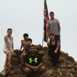
My sister brought me here for a hike and I absolutely loved it! Think it's my new favorite! The scenery is beautiful! read more


13 years ago
7 years ago
10 years ago
10 years ago
More info about Hollenbeck Canyon Wildlife Area
Ask the Community - Hollenbeck Canyon Wildlife Area
Is hunting allowed? Specifically rabbit hunting?
Review Highlights - Hollenbeck Canyon Wildlife Area
You might also consider


Why does Yelp recommend reviews?
Hollenbeck Canyon Wildlife Area - hiking - Updated June 2026
Best of Jamul
People found Hollenbeck Canyon Wildlife Area by searching for…
Hot Springs in Jamul, California
Things to Do in Jamul, California
Scenic View in Jamul, California
Off Road Trails in Jamul, California
Shaded Hike in Jamul, California
Waterfall in Jamul, California
Dirt Bike Trails in Jamul, California
Abandoned Places in Jamul, California
Secret Spots in Jamul, California
Mountain Bike Trails in Jamul, California
Bike Paths in Jamul, California
Hiking Trails With Waterfalls in Jamul, California
Places to Run in Jamul, California
Places to Walk in Jamul, California
Kid Friendly Hiking Trails in Jamul, California
Open Fields Trails in Jamul, California
Running Trails in Jamul, California
Walking Trails in Jamul, California
Secluded Spots in Jamul, California
Nature Walks in Jamul, California
Trending Searches in Jamul, CA
Black Owned Nail Salons near Hollenbeck Canyon Wildlife Area
Boat Rental near Hollenbeck Canyon Wildlife Area
Cliff Jumping near Hollenbeck Canyon Wildlife Area
Day Trips near Hollenbeck Canyon Wildlife Area
Fishing Spots near Hollenbeck Canyon Wildlife Area
Jet Ski Rental near Hollenbeck Canyon Wildlife Area
Kayak Rental near Hollenbeck Canyon Wildlife Area
Lakes & Ponds near Hollenbeck Canyon Wildlife Area
Off Road Trails near Hollenbeck Canyon Wildlife Area
Outdoor Activities near Hollenbeck Canyon Wildlife Area
Pick Your Own Farms near Hollenbeck Canyon Wildlife Area
Places To Walk Around near Hollenbeck Canyon Wildlife Area
Public Shower near Hollenbeck Canyon Wildlife Area
River Swimming near Hollenbeck Canyon Wildlife Area
Rock Quarry near Hollenbeck Canyon Wildlife Area
Running Trails near Hollenbeck Canyon Wildlife Area
Scenic Night View near Hollenbeck Canyon Wildlife Area
Scenic Overlook near Hollenbeck Canyon Wildlife Area
Secluded Spots near Hollenbeck Canyon Wildlife Area
Soccer Store near Hollenbeck Canyon Wildlife Area
Splash Pad near Hollenbeck Canyon Wildlife Area
Strawberry Picking near Hollenbeck Canyon Wildlife Area
Sunrise View near Hollenbeck Canyon Wildlife Area
Swimming Holes near Hollenbeck Canyon Wildlife Area
Swimming Lakes near Hollenbeck Canyon Wildlife Area
Watch Sunset near Hollenbeck Canyon Wildlife Area
Water Parks near Hollenbeck Canyon Wildlife Area
Waterfalls And Swimming Holes near Hollenbeck Canyon Wildlife Area
Browse Articles
Browse Nearby
Browse Brands
Related Searches in Jamul, CA
Affordable Kayak Rental Services in Jamul, California
Best Fishing Locations and Guides in Jamul, California
Best Places for Horseback Riding in Jamul, California
Best Waterfalls and Swimming Holes in Jamul, California
Check Out Off Road Trails in Jamul, California
Discover Dog Friendly Trails to Explore in Jamul, California
Discover Scenic Hiking Trails in Jamul, California
Discover Scenic Mountain Bike Trails Near Jamul, California
Discover Walking Parks in Jamul, California Near You
Discover a Hiking Trail in Jamul, California
Discover the Best Night Hike Trails in Jamul, California
Dog-Friendly Hikes With Dogs in Jamul, California
Enjoy Camping Adventures Around Jamul, California
Enjoy Exciting Mountain Biking Adventures in Jamul, California
Enjoy Kayaking Adventures in Jamul, California
Enjoy Tent Camping Spots Around Jamul, California
Enjoy a Beautiful Waterfall Hike in Jamul, California
Enjoy a Peaceful Nature Walk in Jamul, California
Enjoy the Best Picnic Spots and Ideas in Jamul, California
Enjoy the Best Walking Path in Jamul, California
Enjoy the Best Walking Trails in Jamul, California
Exciting Cliff Jumping Spots in Jamul, California
Explore Beautiful Parks and Green Spaces in Jamul, California
Explore Easy Hikes Perfect for All in Jamul, California
Explore Fun Activities to Do in Jamul, California
Explore Popular Campgrounds Near Jamul, California
Explore the Best Beach Spots in Jamul, California
Explore the Best Trail Options in Jamul, California
Family Friendly Hiking With Kids in Jamul, California
Find Beautiful Views in Jamul, California
Find Popular Ziplining Spots Around Jamul, California
Find the Best Parks for Picnics in Jamul, California
Find the Best Scenic View Locations in Jamul, California
Great Places to Walk in Jamul, California
Hike the Popular Waterfall Trail in Jamul, California
Hiking Trails With Waterfalls in Jamul, California
Off Leash Dog Hiking Trails in Jamul, California
Plan a Scenic Drive Route Near Jamul, California
Popular Outdoor Activities to Try in Jamul, California
Popular Picnic Spots to Visit in Jamul, California
Safe River Swimming Areas in Jamul, California
Safe and Fun Parks for Kids in Jamul, California
Top Climbing Spots and Gyms in Jamul, California
Top Paddleboarding Activities in Jamul, California
Top Places for Snorkeling in Jamul, California
Top Running Trails to Explore in Jamul, California
Top Swimming Lakes to Enjoy in Jamul, California
Top Swimming Spots and Pools in Jamul, California