
Indian Valley Trail
Indian Valley Trail Photos


You might also consider
More like Indian Valley Trail
Recommended Reviews - Indian Valley Trail
Start your review...

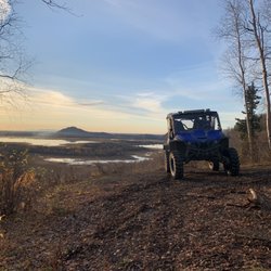
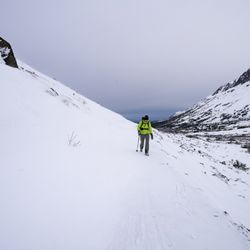
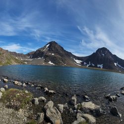
So, it's kind of hard to find information on this trail, so I'll help ya'll out. GETTING HERE: From the Seward Highway, go north (a right if you're heading towards Anchorage, a left if you're heading away from Anchorage) on Boretide Rd (right next to the new Turnagain Arm Pit BBQ location). Where the marker is for this Yelp listing, is where the paved road ends. Just keep going straight! The road can be a little bumpy but nothing that would require high-clearance or 4WD/AWD. Eventually, after what seems like a long time (but isn't), you'll end up at the trailhead. Officially, this trailhead is called "Indian Valley Trailhead". Chugach State Park's website is horrible (they have some great .pdf's for some of their trails, but good luck finding them anywhere on their website...), so I was only able to find most of this information from: googling, using summitpost (a climbing website), and browsing blogs. Hopefully, this consolidated source of information will be helpful to some! From this trailhead, you can access two trails: Powerline Pass: which has its other end at the Glen Alps area (Flattop) Indian Valley Trail: a trail of controversial quality (I have never done it) that goes NE from this trailhead and eventually meets the Ship Creek Trail. (About 1/4 of a mile up the trail you'll come to a junction: if you go straight you'll be on Indian Valley Trail, if you take a left, and go over a footbridge, you'll be on Powerline Pass trail) I'll be mainly speaking of Powerline Pass. Most folks start Powerline Pass up near Glen Alps. Most folks mountain bike* it, rather than hike it. Most folks would need a bike with a good suspension to do this. I do not have such a faithful, two-wheeled steed, so I hike. Why hike it from this side? A couple reasons: 1) This is the approach hike to climb Homicide Peak: this is how I originally found the trail. Homicide Peak is a fun scramble with awesome views of the Suicide Peaks. More info on climbing Homicide can be found here: http://www.summitpost.org/homicide-peak/815642 2) Crowds: there aren't many. This trail isn't as well-known or popular as many others in the area. 3) Feasting options: Froth and Forage (https://www.yelp.com/biz/froth-and-forage-coffeehouse-and-eatery-anchorage) is open till 10 pm, and located very close to this trailhead. Hiking early in the morning? Stop in for a coffee. Hiking late in the evening? Stop in for a burger! 4) Get out of your usual rut: expand your mind, hike some new stuff! Reasons you might want to be a bit leery of this trail: 1) I've heard the Indian Valley Trail can be miserable and overgrown in spots. I hope you like bushwhacking. Or 'schwacking, for short. 2) There can be lots of bear activity in this area. Carry your spray, take your dog, hike in a group. 3) If there's been recent rain, it can get pretty muddy. Definitely, give this trail a shot! *for info on mountain biking Powerline Pass, check out this slick website: https://www.mtbproject.com/trail/6452974/powerline-pass read more
 - Hiking Near Me - Anchorage, Alaska")


More info about Indian Valley Trail


Indian Valley Trail - hiking - Updated July 2026
Best of Anchorage
People found Indian Valley Trail by searching for…
Hiking Trails in Anchorage, AK
Walking Trails in Anchorage, AK
Rock Climbing Gyms in Anchorage, AK
Dog Friendly Trails in Anchorage, AK
Off Road Trails in Anchorage, AK
Dirt Bike Riding in Anchorage, AK
White Water Rafting in Anchorage, AK
Electric Bike Shop in Anchorage, AK
Running Trails in Anchorage, AK
National Parks in Anchorage, AK
Specialized Bike Shop in Anchorage, AK
Beautiful Views in Anchorage, AK
Hiking With Kids in Anchorage, AK
Trending Searches in Anchorage, AK
Beautiful Views near Indian Valley Trail
Boat Tours near Indian Valley Trail
Day Trips near Indian Valley Trail
Dog Friendly Trails near Indian Valley Trail
Free Picnic Areas near Indian Valley Trail
Kayak Rental near Indian Valley Trail
Off Road Trails near Indian Valley Trail
Outdoor Activities near Indian Valley Trail
Parks near Indian Valley Trail
Parks For Picnics near Indian Valley Trail
Places To Swim near Indian Valley Trail
Public Shower near Indian Valley Trail
River Swimming near Indian Valley Trail
Rock Quarry near Indian Valley Trail
Scenic Overlook near Indian Valley Trail
Soccer Store near Indian Valley Trail
Sunrise View near Indian Valley Trail
Swimming Holes near Indian Valley Trail
Swimming Lakes near Indian Valley Trail
Browse Articles
Browse Nearby
Browse Brands
Related Searches in Anchorage, AK
Affordable Bike Repair Services in Anchorage, Alaska
Affordable Kayak Rental Services in Anchorage, Alaska
Best Dirt Bike Riding Spots in Anchorage, Alaska
Best Dog Hiking Trails Around Anchorage, Alaska
Best Fishing Locations and Guides in Anchorage, Alaska
Best Fun Things to Do in Anchorage, Alaska
Best Gym With Sauna Amenities in Anchorage, Alaska
Best Nature Trails for Hiking in Anchorage, Alaska
Best Places for Horseback Riding in Anchorage, Alaska
Best Sightseeing Experiences Available in Anchorage, Alaska
Best Sledding Spots and Fun in Anchorage, Alaska
Best Spinning Classes Offered in Anchorage, Alaska
Challenge Yourself With an Obstacle Course in Anchorage, Alaska
Check Out Off Road Trails in Anchorage, Alaska
Convenient Bike Sharing Programs in Anchorage, Alaska
Discover Boot Camps Options in Anchorage, Alaska
Discover Dance Studios Available in Anchorage, Alaska
Discover Dog Friendly Trails to Explore in Anchorage, Alaska
Discover Great Fitness Classes Available in Anchorage, Alaska
Discover Gyms With Steam Room Options in Anchorage, Alaska
Discover Kids Indoor Play Area Venues in Anchorage, Alaska
Discover Popular Bike Tours in Anchorage, Alaska
Discover Popular Bike Trails in Anchorage, Alaska
Discover Scenic Mountain Bike Trails Near Anchorage, Alaska
Discover Top Yoga Options and Studios in Anchorage, Alaska
Discover a Hiking Trail in Anchorage, Alaska
Discover the Best Beaches in Anchorage, Alaska
Discover the Best Night Hike Trails in Anchorage, Alaska
Dog-Friendly Hikes With Dogs in Anchorage, Alaska
Enjoy Camping Adventures Around Anchorage, Alaska
Enjoy Exciting Mountain Biking Adventures in Anchorage, Alaska
Enjoy Hiking Adventures in Anchorage, Alaska
Enjoy Kayaking Adventures in Anchorage, Alaska
Enjoy Off Leash Dog Hikes in Anchorage, Alaska
Enjoy Tent Camping Spots Around Anchorage, Alaska
Enjoy a Beautiful Waterfall Hike in Anchorage, Alaska
Enjoy the Best Bouldering Experiences in Anchorage, Alaska
Enjoy the Best Tubing Experiences in Anchorage, Alaska
Enjoy the Best Walking Trails in Anchorage, Alaska
Exciting Things to Do in Anchorage, Alaska Today
Explore Beautiful Parks and Green Spaces in Anchorage, Alaska
Explore Bike Rentals Throughout Anchorage, Alaska
Explore Boxing Gyms in Anchorage, Alaska
Explore Easy Hikes Perfect for All in Anchorage, Alaska
Explore Fitness Centers and Gyms in Anchorage, Alaska