Jean Lafitte I-10 Bridge Photos


More like Jean Lafitte I-10 Bridge
Recommended Reviews - Jean Lafitte I-10 Bridge
Start your review...

Reviews With Photos

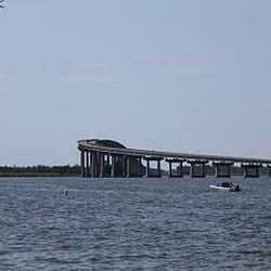
This is the bridge that takes you right into Lake Charles, Louisiana on the Interstate 10 freeway. I've drove from Houston to Lake Charles plenty of times way back when, this bridge always lets me know when I've arrived. There are 2 of these bridges here, this is the straight one, the other one has a big curve. You can't walk across this bridge, vehicles only, and it's been here a long time, they obviously built this to last!!

Another installment of fun facts for bridge fans: The name Jean Lafitte Bridge as an homage to the pirate of fame and legend is rumored to have been recorded on some early building plans but the US-90 bridge was officially christened the World War II Memorial Bridge (or some variant thereof) in 1952; the bridge later became the I-10 bridge. Pedestrian walkways on the bridge made it functionally obsolete as an interstate highway bridge from the start and for this and other reasons it needed replacing. The federal government promised to do that "shortly" It's now 67 years later and there's a proposal to install a six lane structure that would be "iconic" rather than pragmatic with a start date of sooner rather than later. It is also rumored to include pedestrian walkways. The current 6600-foot long cantilever bridge rises 135 feet above the waterway with a center span of 420 feet. The railings include 5,286 pairs of decorative crossed cast-iron pistols to recognize the local affinity for chicanery on the high seas and elsewhere.

Surprised that I have not reviewed this bridge with all of the trips that I've made from Houston to New Orleans and then back to Houston. Not as impressive as many of the other bridges in Louisiana, but think about how people would have travelled in the early 1900s with mosquitoes carrying Yellow Fever, no interstate highways, no air conditioning and limited bridges. The challenges were real. In fact, in 1900 the U.S. Army research corps proved that mosquitoes carried and transmitted Yellow Fever. Many people dismissed medical science. That distrust led to a massive outbreak of Yellow Fever in 1905 in New Orleans. Over 3,000 people were infected. About 450 people died. Public health to the rescue. Using simple methods to decrease breeding grounds and spraying for mosquitoes, that was the last outbreak in North America. Amazing. (There is a vaccine available if you travel to an area where Yellow Fever is still endemic.) Gives you something to think about while traveling on the interstate in a nice air conditioned car towing a trailer from New Orleans to Houston. Even if the interstate seems to always be under construction, at least the bridges are there to cross another large body of water. read more


Very high bridge that was just a little bit scary. I've been over taller bridges but the low railing at the side might be adding to the fright factor. Officially the Louisiana Memorial World War II bridge it is a through truss bright that carries I-10 between Lake Charles and Westlake, Louisiana and over the Calcasieu River. The bridge has a vertical clearance of 135 feet and was opened in 1952. The bridge predates the Interstate Highway System and is rated as "functionally obsolete". It has had some structural deficiency reports and therefore the top speed on the bridge has been lowered to 50 mph. It was reported as "dangerous" and the 7th in the United States that is in need of replacing. That said, I crossed the bridge successfully though I think I would detour next time. [Review 17370 overall - 81 in Louisiana - 888 of 2022.] read more


This is the bridge that takes you right into Lake Charles, Louisiana on the Interstate 10 freeway. I've drove from Houston to Lake Charles plenty of times way back when, this bridge always lets me know when I've arrived. There are 2 of these bridges here, this is the straight one, the other one has a big curve. You can't walk across this bridge, vehicles only, and it's been here a long time, they obviously built this to last!! read more


8 years ago
Another installment of fun facts for bridge fans: The name Jean Lafitte Bridge as an homage to the pirate of fame and legend is rumored to have been recorded on some early building plans but the US-90 bridge was officially christened the World War II Memorial Bridge (or some variant thereof) in 1952; the bridge later became the I-10 bridge. Pedestrian walkways on the bridge made it functionally obsolete as an interstate highway bridge from the start and for this and other reasons it needed replacing. The federal government promised to do that "shortly" It's now 67 years later and there's a proposal to install a six lane structure that would be "iconic" rather than pragmatic with a start date of sooner rather than later. It is also rumored to include pedestrian walkways. The current 6600-foot long cantilever bridge rises 135 feet above the waterway with a center span of 420 feet. The railings include 5,286 pairs of decorative crossed cast-iron pistols to recognize the local affinity for chicanery on the high seas and elsewhere. read more

This is the Lake Charles I-10 Bridge (I-10 Calcasieu River Bridge), or simple the I-10 Bridge as refered to by the locals of Lake Charles, Lousiana. Growing up in Calcasieu Parish of Southwest Lousiana, I never really devoted much time to think about this bridge even though it is surely a local landmark due to it being one of the three tallest structures in the area (135 feet) until the building of L'Auberge du Lac Resort, the tallest building between Houston and Baton Rouge. All I knew about the bridge was that it was big. The I-10 Bridge is located about where the Calcasieu River meets the lake that shares the name of the city, crossing the river to connect Lake Charles to Westlake, La. The design of the bridge itself is reflective of the culture of the region where it stands. The railing features crossed pistols that span its length. Even though the reason for the crossed pistols is not universally agreed upon, many hold it to be true that it is a gesture to celebrate the legacy of pirates who frequented Southwest Louisiana waterways, the most famous being Jean Lafitte. Legend says that Jean Lafitte buried some of his smuggled contraband in the area. But, Jean Lafitte's contraband did not only consist of material treasures, he also smuggled slaves into the state. The Lake Charles I-10 Bridge was built in 1952 under the governorship of Earl K. Long, brother of legendary former Louisiana governor and U.S. Senator Huey P. Long. 2009, the Louisiana DOTD released a statement proclaiming "the Interstate 10 bridge in Lake Charles is safe" despite receiving a Structural Evaluation rating of 3 by the NBI on a 0-9 scale. A rating of 3 denotes a structure is "basically intolerable requiring high priority of corrective action." This designation does not barr traffic on the roadway, but speed and weight limits are put into place. read more


10 years ago
More info about Jean Lafitte I-10 Bridge
Ask the Community - Jean Lafitte I-10 Bridge


Jean Lafitte I-10 Bridge - landmarks - Updated June 2026
Best of Lake Charles
People found Jean Lafitte I-10 Bridge by searching for…
Places to Take Pictures in Lake Charles, Louisiana
Things to Do in Lake Charles, Louisiana
Churches in Lake Charles, Louisiana
Attractions in Lake Charles, Louisiana
Public Services & Government in Lake Charles, Louisiana
Field Trips in Lake Charles, Louisiana
Parking in Lake Charles, Louisiana
Photo Spots in Lake Charles, Louisiana
Tourist Attractions in Lake Charles, Louisiana
Things to See in Lake Charles, Louisiana
Scenic Views in Lake Charles, Louisiana
Scenic Overlook in Lake Charles, Louisiana
Plantation in Lake Charles, Louisiana
Religious Organizations in Lake Charles, Louisiana
Sightseeing in Lake Charles, Louisiana
Lighthouses in Lake Charles, Louisiana
View Points in Lake Charles, Louisiana
Fun Things to Do at Night in Lake Charles, Louisiana
Boardwalk in Lake Charles, Louisiana
Landmarks in Lake Charles, Louisiana
Places to Visit in Lake Charles, Louisiana
What to Do in Lake Charles, Louisiana
Trending Searches in Lake Charles, LA
Boat Rental near Jean Lafitte I-10 Bridge
Day Trips near Jean Lafitte I-10 Bridge
Fishing Spots near Jean Lafitte I-10 Bridge
Hiking near Jean Lafitte I-10 Bridge
Kayak Rental near Jean Lafitte I-10 Bridge
Landmarks & Historical Buildings near Jean Lafitte I-10 Bridge
Picnic Areas near Jean Lafitte I-10 Bridge
Places To Swim near Jean Lafitte I-10 Bridge
Places To Visit near Jean Lafitte I-10 Bridge
Splash Pad near Jean Lafitte I-10 Bridge
Swimming Holes near Jean Lafitte I-10 Bridge
Swimming Lakes near Jean Lafitte I-10 Bridge
Water Parks near Jean Lafitte I-10 Bridge
Browse Articles
Browse Nearby
BEST of Lake Charles, Louisiana Restaurants near Jean Lafitte I-10 Bridge
BEST of Lake Charles, Louisiana Things to Do near Jean Lafitte I-10 Bridge
BEST of Lake Charles, Louisiana Coffee near Jean Lafitte I-10 Bridge
BEST of Lake Charles, Louisiana Shopping near Jean Lafitte I-10 Bridge
BEST of Lake Charles, Louisiana Breakfast near Jean Lafitte I-10 Bridge
BEST of Lake Charles, Louisiana Fun near Jean Lafitte I-10 Bridge
BEST of Lake Charles, Louisiana Hotels near Jean Lafitte I-10 Bridge
Browse Brands
Related Searches in Lake Charles, LA
Best Fishing Locations and Guides in Lake Charles, Louisiana
Best Fun Things to Do in Lake Charles, Louisiana
Best Places for Stunning Views in Lake Charles, Louisiana
Discover Family-Friendly Aquariums in Lake Charles, Louisiana
Discover Fun Kid Activities to Enjoy in Lake Charles, Louisiana
Discover Historic Sites and Places in Lake Charles, Louisiana
Discover Popular Landmarks in Lake Charles, Louisiana
Discover Top Nature Parks to Visit in Lake Charles, Louisiana
Discover the Best Beaches in Lake Charles, Louisiana
Enjoy Arts & Entertainment in Lake Charles, Louisiana
Enjoy Hiking Adventures in Lake Charles, Louisiana
Enjoy the Best Family Activities in Lake Charles, Louisiana
Enjoy the Scenic Boardwalk Attractions in Lake Charles, Louisiana
Experience the Best Family Fun in Lake Charles, Louisiana for All
Explore Beautiful Castles and Landmarks in Lake Charles, Louisiana
Explore Beautiful Parks and Green Spaces in Lake Charles, Louisiana
Explore Family-Friendly Zoos and Wildlife in Lake Charles, Louisiana
Explore Fun Activities to Do in Lake Charles, Louisiana
Explore Popular View Points Around Lake Charles, Louisiana
Explore Scenic Lakes to Visit in Lake Charles, Louisiana
Explore Sunday Fun Things to Do in Lake Charles, Louisiana
Explore Top Art Galleries Located in Lake Charles, Louisiana
Explore Top History Museums in Lake Charles, Louisiana
Explore Venues & Event Spaces in Lake Charles, Louisiana
Find Exciting Tours to Take in Lake Charles, Louisiana
Find Fun Things to Do With Kids in Lake Charles, Louisiana
Find Top Art Museums in Lake Charles, Louisiana
Find Top Libraries to Visit in Lake Charles, Louisiana
Find Visitor Centers to Explore in Lake Charles, Louisiana
Find the Best Bridge Spots in Lake Charles, Louisiana
Find the Best Playgrounds to Visit in Lake Charles, Louisiana
Fun Things for Kids in Lake Charles, Louisiana
Must-See Tourist Attractions Around Lake Charles, Louisiana
Popular Kids Activities in Lake Charles, Louisiana
Popular Outdoor Activities to Try in Lake Charles, Louisiana
Popular Places to Take Pictures in Lake Charles, Louisiana
Popular Things to Do in Lake Charles, Louisiana
Public Services & Government Offices in Lake Charles, Louisiana
Relax at Natural Hot Springs Near Lake Charles, Louisiana
Secure Convenient Parking Options in Lake Charles, Louisiana
See Top Fireworks Events in Lake Charles, Louisiana
Top Entertainment Options in Lake Charles, Louisiana
Top Fun Things to Do at Night in Lake Charles, Louisiana
Top Historic Restaurants to Try in Lake Charles, Louisiana
Top Places to Visit in Lake Charles, Louisiana for Sightseeing
Top Things to Do With Kids in Lake Charles, Louisiana
Tour Famous Lighthouses Located in Lake Charles, Louisiana
Visit Beautiful Gardens in Lake Charles, Louisiana