Little Stony Man Trailhead Photos


You might also consider
More like Little Stony Man Trailhead
Recommended Reviews - Little Stony Man Trailhead
Start your review...

Reviews With Photos

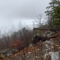
A quick and easy hike that is great for beginners. The views at the overlook are beautiful. It took about an hour to get to the top. Started out hike at 620ish to and arrived to the peak for the sunrise. The peak doesn't face east so it's not facing the sun coming but you the view is still amazing with cotton candy colored skies.

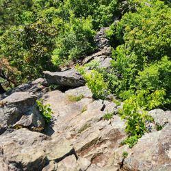
At the 41 mile marker on Skyline Drive, you will see a sign to turn into Skyland. After you turn, the parking lot for the trails to the Stony Man and Little Stony Man summits is immediately to your right. I did the Passamaquoddy Loop, which is the Little Stony Man hike, but made a detour to the Stony Man Summit. I would recommend starting the hike in a counterclockwise direction. About ten minutes on the trail, it splits in two. One way is straight and the other way veers to the right. Go straight to get to the Stony Man summit. I highly recommend the Stony Man summit. Similar to the top of Hawksbill, the views are absolutely spectacular and include the Shenandoah Valley, the town of Luray, and the Massanutten and Alleghany Mountains. Since it was partly cloudy when I got to the summit, the clouds split the sun rays up so it looked like a door from heaven opened up and God touched the valley with his hands. I give views on the top of Stony Man a slight edge over the views at the top of Hawksbill. I also think the rock formations at the clearing on top of Stony Man are prettier. It takes about 20 minutes to get to the top from the parking lot and the elevation change is only 340 feet. Accordingly, it is an easier hike than Hawksbill too. Of course, both are easy hikes and definitely worth the time. You can definitely do both on the same day since they are so close to each other. From the summit of Stony Man, I walked back toward the same direction I came from and took a sharp turn to where the road split and veered right in order to hike to Little Stony Man. To be honest, the views at Little Stony Man are good but do not match Stony Man. Consequently, hiking the loop to see Little Stony Man is more for exercise as it is 3.5 miles with a 770 feet elevation change. It is a decent workout but not strenuous. I definitely recommend completing the counterclockwise loop rather than going to Little Stony Man then going back up from where you came from because it is much steeper. The second half of the loop has a lot more rocks. Although parts of it are a little bit narrow and you can see the steep hill to your right, you can hug the inside of the trail if you are afraid of heights. You are not in danger of slipping off the path unless you are extremely careless. There is also a sharp turn near the end of the Passamaquoddy Trail to link to the Furnace Spring Horse Trail that heads back to the parking lot instead of connecting to a trail that heads to Skyland. As a hint, you will see a door for a shack built into rocks and an electrical line above that are landmarks for the sharp turn left. If you are planning a trip to Shenandoah National Park and looking for recommendations, feel free to message me for my itinerary. You can also find the electronic copy through the link my profile.

Finally the humidity is down!!! This started out being a nice 2 mile round trip. Apparently, I missed some signage and ended up at the Skyline Resort! Thats me being me I guess. The first mile view here was great though its the same view from Hughes Gap Overlook. I kept going and passed some rock climbers. Harnesses and ropes . Looked cool. Ended up at the resort. Took the fire road and horse trail back and I ended up at the overlook again. The did have markers but I thought they were confusing. So did 2 other couples I met. It was fun though.

Oct, 2025. The Stony Man summit (elevation 4,003') is accessible via multiple hiking routes in Shenandoah National Park. My husband and I parked at the lot at mile marker 41.7 on Skyline Drive; the trailhead and an informational sign are easy to access, just off the parking lot. This is a lollipop trail that is rated moderate in AllTrails. My watch recorded a total of 1.8 miles total with an elevation gain of 338'. This is a well-maintained, uphill-climbing trail that leads to overviews with beautiful views. Some quick, random notes: *Once you reach the circular part of the lollipop, the trail to the right is rocky; the path to the left is smoother. You can elect to take one up, and the other down. *We visited in mid-October during leaf-peeping season. The parking lot and the trails near Stony Man were very crowded mid-day. *As you approach the summit, most hikers go to the rocky overview on the right, where there are sweeping views of the valley below. Note, however, that there is another very nice, and smoother rock, overview just five minutes back, just off the main trail. *Shenandoah National Park charges an admission fee. read more


3 months ago
So this peak can apparently be reached via a few different trails (I think...). We originally were considering starting from a trailhead along Skyline Drive but (after miraculously scoring one of a very limited # of parking spots) had to abandon that... Instead, a bit later in the day, we started the ascent from a different trailhead not far from Skyland (on its approach road). You basically leave from the parking lot and hike about 0.2 miles to an intersection with the Appalachian Trail. From there, you ascend a single trail towards the summit, which diverges to form a loop closer to the top. It isn't super steep either way. We made it to the summit and enjoyed the views. It appeared that you could descend slightly on a different trail and have good views from another spot about 25 feet below the crest. We did not do that, though. We hiked back down the other branch of the loop. We had to hurry due to our need to get in line for the Skyland dining room when it opened at 5 p.m. This is a worthwhile hike if you have time. You can probably ask the rangers / info desk at Skyland for better guidance on the merits of the various trails that lead up to the summit. read more

3 years ago
8 years ago
A quick and easy hike that is great for beginners. The views at the overlook are beautiful. It took about an hour to get to the top. Started out hike at 620ish to and arrived to the peak for the sunrise. The peak doesn't face east so it's not facing the sun coming but you the view is still amazing with cotton candy colored skies. read more


9 years ago
At the 41 mile marker on Skyline Drive, you will see a sign to turn into Skyland. After you turn, the parking lot for the trails to the Stony Man and Little Stony Man summits is immediately to your right. I did the Passamaquoddy Loop, which is the Little Stony Man hike, but made a detour to the Stony Man Summit. I would recommend starting the hike in a counterclockwise direction. About ten minutes on the trail, it splits in two. One way is straight and the other way veers to the right. Go straight to get to the Stony Man summit. I highly recommend the Stony Man summit. Similar to the top of Hawksbill, the views are absolutely spectacular and include the Shenandoah Valley, the town of Luray, and the Massanutten and Alleghany Mountains. Since it was partly cloudy when I got to the summit, the clouds split the sun rays up so it looked like a door from heaven opened up and God touched the valley with his hands. I give views on the top of Stony Man a slight edge over the views at the top of Hawksbill. I also think the rock formations at the clearing on top of Stony Man are prettier. It takes about 20 minutes to get to the top from the parking lot and the elevation change is only 340 feet. Accordingly, it is an easier hike than Hawksbill too. Of course, both are easy hikes and definitely worth the time. You can definitely do both on the same day since they are so close to each other. From the summit of Stony Man, I walked back toward the same direction I came from and took a sharp turn to where the road split and veered right in order to hike to Little Stony Man. To be honest, the views at Little Stony Man are good but do not match Stony Man. Consequently, hiking the loop to see Little Stony Man is more for exercise as it is 3.5 miles with a 770 feet elevation change. It is a decent workout but not strenuous. I definitely recommend completing the counterclockwise loop rather than going to Little Stony Man then going back up from where you came from because it is much steeper. The second half of the loop has a lot more rocks. Although parts of it are a little bit narrow and you can see the steep hill to your right, you can hug the inside of the trail if you are afraid of heights. You are not in danger of slipping off the path unless you are extremely careless. There is also a sharp turn near the end of the Passamaquoddy Trail to link to the Furnace Spring Horse Trail that heads back to the parking lot instead of connecting to a trail that heads to Skyland. As a hint, you will see a door for a shack built into rocks and an electrical line above that are landmarks for the sharp turn left. If you are planning a trip to Shenandoah National Park and looking for recommendations, feel free to message me for my itinerary. You can also find the electronic copy through the link my profile. read more


3 years ago
11 years ago
Finally the humidity is down!!! This started out being a nice 2 mile round trip. Apparently, I missed some signage and ended up at the Skyline Resort! Thats me being me I guess. The first mile view here was great though its the same view from Hughes Gap Overlook. I kept going and passed some rock climbers. Harnesses and ropes . Looked cool. Ended up at the resort. Took the fire road and horse trail back and I ended up at the overlook again. The did have markers but I thought they were confusing. So did 2 other couples I met. It was fun though. read more


11 years ago
Excellent! Fairly easy uphill to the top. About 2 miles round trip. Fantastic views from the top!! Absolutely recommend! read more

8 years ago
More info about Little Stony Man Trailhead
Ask the Community - Little Stony Man Trailhead
Review Highlights - Little Stony Man Trailhead


Little Stony Man Trailhead - hiking - Updated June 2026
Best of Syria
People found Little Stony Man Trailhead by searching for…
Hiking Trails in Syria, Virginia
Things to Do in Syria, Virginia
Off Road Trails in Syria, Virginia
Secret Spots in Syria, Virginia
Hiking With Kids in Syria, Virginia
Things to See in Syria, Virginia
Sunrise View in Syria, Virginia
Star Gazing in Syria, Virginia
Lookout Points in Syria, Virginia
Walking Trails in Syria, Virginia
Waterfalls and Swimming Holes in Syria, Virginia
Beautiful Views in Syria, Virginia
Sunset View in Syria, Virginia
Scenic Overlook in Syria, Virginia
Tourist Attractions in Syria, Virginia
Scenic Views in Syria, Virginia
Skyline View in Syria, Virginia
Canyoneering in Syria, Virginia
Dinosaur Park in Syria, Virginia
Browse Nearby
BEST of Syria, Virginia Restaurants near Little Stony Man Trailhead
BEST of Syria, Virginia Things to Do near Little Stony Man Trailhead
BEST of Syria, Virginia Coffee near Little Stony Man Trailhead
BEST of Syria, Virginia Shopping near Little Stony Man Trailhead
BEST of Syria, Virginia Breakfast near Little Stony Man Trailhead
BEST of Syria, Virginia Wineries near Little Stony Man Trailhead