Long Point Portage Historical Marker Photos

More like Long Point Portage Historical Marker
Recommended Reviews - Long Point Portage Historical Marker
Start your review...



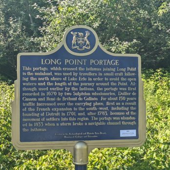
Located not far from the Old Cut Lighthouse, this marker points out some of the travel history of the area, going back to before roads and everything happened by ship. The marker reads, "This portage, which crossed the isthmus joining Long Point to the mainland, was used by travellers in small craft following the north shore of Lake Erie in order to avoid the open waters and the length of the journey around the Point. Although used earlier by the Indians, the portage was first recorded in 1670 by two Sulpician missionaries, Dollier de Casson and René de Bréhant de Galinée. For about 150 years traffic increased over the carrying place, first as a result of the French expansion to the south-west, including the founding of Detroit in 1701, and, after 1783, because of the movement of settlers into this region. The portage was abandoned in 1833 when a storm broke a navigable channel through the isthmus." The marker was erected by the Archaeological and Historic Sites Board, Ministry of Colleges and Universities and it has the text in French on the reverse. There is parking here and it's metered so be sure to check dates and times before leaving your vehicle. [Review 1432 of 2024 - 110 in Ontario - 22455 overall] read more