Manastash Ridge Viewpoint Photos


More like Manastash Ridge Viewpoint
Recommended Reviews - Manastash Ridge Viewpoint
Start your review...

3 years ago
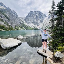
One of my favorite hikes! Went in 5th grade, 6th, 8th, and a couple more times in my adult hood. It's a steep climb but you get to your destination faster. Theres also a notebook you get to sign that the ellensburg library (I think) keeps on record each year! read more


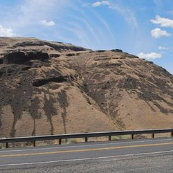
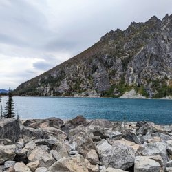
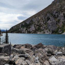
The Manastash Ridge Viewpoint is easily accessible from Route 97 (Interstate 82) and the road that takes you to the overlook is clearly marked on the highway. It is a nice place to get out of the car and stretch one's legs. The views are spectacular as are the rocks forming the cliffs/mountains around the parking area at the viewpoint. There is a light grayish yellow rock outcropping here that is overlain by some volcanic rocks. A very cool place indeed geologically. Watch out for big bugs when out of the car. They are friendly. read more


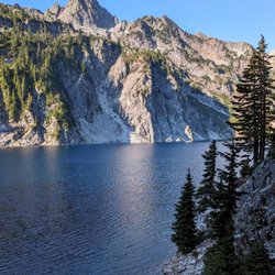
The view from this ridge on a clear day is pretty spectacular and breathtaking. It's the last ridge just before you drop down into the valley where Ellensburg sets and it is hard to do justice without seeing it! There are a few points from either side of the highway, depending on which direction you're traveling. The slightly better views are at the viewpoint heading towards Yakima, however the highway is in front of you so it can be a little bit tougher to get really good pictures. The valley down below with agricultural clots creates a beautiful agricultural place setting that gradually ascends into ruggedly majestic mountains that are often snowcapped. If you drive through here early in the morning, sometimes a fog sits overtop and it literally looks like the mountains are rising from the clouds. Couple this with the colors of the sunrise reflecting off the clouds in the mountains, or watching the sunset behind the mountains and casting Longshadows over the valley - It's the sort of scene that you seldom come across and that pictures can never fully capture. Whether you've been over this ridge once or 1000 times, you owe it to yourself to stop here and take in some of the beauty on a clear day. read more


More info about Manastash Ridge Viewpoint
Ellensburg, WA 98926
Directions
Visit Website
http://www.wta.org
Hours
Outdoor Amenities


Manastash Ridge Viewpoint - hiking - Updated July 2026
Best of Ellensburg
People found Manastash Ridge Viewpoint by searching for…
Hiking Trails in Ellensburg, WA
Swimming Lakes in Ellensburg, WA
Beautiful Views in Ellensburg, WA
Things to Do in Ellensburg, WA
Places to Take Pictures in Ellensburg, WA
Hiking With Kids in Ellensburg, WA
Watch Sunset in Ellensburg, WA
Sunrise View in Ellensburg, WA
Scenic Overlook in Ellensburg, WA
Walking Trails in Ellensburg, WA
Tent Camping in Ellensburg, WA
Off Road Trails in Ellensburg, WA
Lookout Points in Ellensburg, WA
Running Trails in Ellensburg, WA
Playgrounds for Kids in Ellensburg, WA
Trending Searches in Ellensburg, WA
Blueberry Picking near Manastash Ridge Viewpoint
Boating near Manastash Ridge Viewpoint
Cliff Jumping near Manastash Ridge Viewpoint
Day Trips near Manastash Ridge Viewpoint
Dog Friendly Things To Do near Manastash Ridge Viewpoint
Dog Swimming near Manastash Ridge Viewpoint
Jet Skis near Manastash Ridge Viewpoint
Kayak Rental near Manastash Ridge Viewpoint
Lakes near Manastash Ridge Viewpoint
Lookout Points near Manastash Ridge Viewpoint
Outdoor Activities near Manastash Ridge Viewpoint
Parks near Manastash Ridge Viewpoint
Peach Picking near Manastash Ridge Viewpoint
River Swimming near Manastash Ridge Viewpoint
River Tubing near Manastash Ridge Viewpoint
Rock Quarry near Manastash Ridge Viewpoint
Sunrise View near Manastash Ridge Viewpoint
Swimming Holes near Manastash Ridge Viewpoint
U Pick Farms near Manastash Ridge Viewpoint
Watch Sunset near Manastash Ridge Viewpoint
Browse Articles
Browse Nearby
Browse Brands
Related Searches in Ellensburg, WA
Affordable Kayak Rental Services in Ellensburg, Washington
Best Dog Hiking Trails Around Ellensburg, Washington
Best Fishing Locations and Guides in Ellensburg, Washington
Best Places for Horseback Riding in Ellensburg, Washington
Check Out Off Road Trails in Ellensburg, Washington
Discover Dog Friendly Trails to Explore in Ellensburg, Washington
Discover Easy Hiking Trails Near Ellensburg, Washington
Discover Top Nature Parks to Visit in Ellensburg, Washington
Discover Top State Parks to Visit in Ellensburg, Washington
Discover a Hiking Trail in Ellensburg, Washington
Discover the Best Night Hike Trails in Ellensburg, Washington
Dog-Friendly Hikes With Dogs in Ellensburg, Washington
Enjoy Camping Adventures Around Ellensburg, Washington
Enjoy Exciting Mountain Biking Adventures in Ellensburg, Washington
Enjoy Off Leash Dog Hikes in Ellensburg, Washington
Enjoy Tent Camping Spots Around Ellensburg, Washington
Enjoy the Best Walking Trails in Ellensburg, Washington
Experience Stunning Sunset Views in Ellensburg, Washington
Explore Beautiful Parks and Green Spaces in Ellensburg, Washington
Explore Easy Hikes Perfect for All in Ellensburg, Washington
Explore Fun Activities to Do in Ellensburg, Washington
Explore Popular Campgrounds Near Ellensburg, Washington
Explore Popular RV Parks Around Ellensburg, Washington
Explore Popular Scenic Overlook Points in Ellensburg, Washington
Explore Scenic Lakes to Visit in Ellensburg, Washington
Explore Top Dog Parks in Ellensburg, Washington Near You
Explore the Best Swimming Holes Around Ellensburg, Washington
Family Friendly Hiking With Kids in Ellensburg, Washington
Find Popular Ziplining Spots Around Ellensburg, Washington
Find the Best Playgrounds to Visit in Ellensburg, Washington
Hiking Trails With Waterfalls in Ellensburg, Washington
Off Leash Dog Hiking Trails in Ellensburg, Washington
Plan a Scenic Drive Route Near Ellensburg, Washington
Popular Fishing Spots to Explore in Ellensburg, Washington
Popular Outdoor Activities to Try in Ellensburg, Washington
Popular Picnic Spots to Visit in Ellensburg, Washington
Safe River Swimming Areas in Ellensburg, Washington
Safe and Fun Parks for Kids in Ellensburg, Washington
Top Hiking Trails to Explore in Ellensburg, Washington
Top Playgrounds for Kids to Enjoy in Ellensburg, Washington
Top Running Trails to Explore in Ellensburg, Washington
Top Swimming Lakes to Enjoy in Ellensburg, Washington
Top Swimming Spots and Pools in Ellensburg, Washington
Top Things to Do With Kids in Ellensburg, Washington
Top-Rated Camping Sites in Ellensburg, Washington
Uncover the Best Secluded Spots Around Ellensburg, Washington
People who viewed Manastash Ridge Viewpoint also viewed
Rocky Top Trails
2 reviews
Ginkgo Petrified Forest State Park
32 reviews
Wanapum State Park
21 reviews
Yakima Area Arboretum
10 reviews
Snow Mountain Ranch
2 reviews
Yakima Canyon
3 reviews
Yakima Sportsman State Park
26 reviews
City Of Vantage
2 reviews
Frenchman Coulee
7 reviews
Rill Adventures Raft and Gear Rentals
71 reviews