Mojave Riverwalk Trailhead Photos


You might also consider
More like Mojave Riverwalk Trailhead
Recommended Reviews - Mojave Riverwalk Trailhead
Start your review...

1 year ago


2 years ago
6 years ago
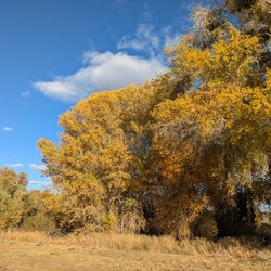
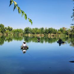
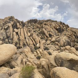
Great outdoor trail without ending up in the dirt..this trail has a small two lane sidewalk where you can walk, or ride a bike throughout the entire trail. You can make up multiple trails to shorten or lengthen your workout. There's no charge if you park on PARK RD right off yates rd.. there's parking right before you get to the gate to pay for entrance. Your trail starts right there. Walk back up to the light and go left. You can go over the bridge or under it. Going under the bridge takes you towards either the college or you can split off and end up on the other side of the bridge, we walked over the bridge and crossed then Came back. That trail is only about 2.5 miles. Once your heading back there's another split to take you down into Mojave narrows. Once you get into Mojave narrows you'll see the lake and there's a park restroom on the opposite side for men and woman right off equestrian center rd. Once you pass the restrooms your back at your car.. have fun!!! read more


6 years ago
More choices in the High Desert to walk or ride a bike. South Mojave Riverwalk runs along Jess Ranch starting behind 24 Hour Fitness. One way 2.74 miles. Mojave Riverwalk Trailhead starts on the lower campus of Victor Valley College and runs along Spring Valley Lake and takes you into Mojave Narrows. The trail is 3.5 miles one way. Bring your good walking shoes and a great attitude. read more


5 years ago
6 years ago
More info about Mojave Riverwalk Trailhead
18564 Bear Valley Rd
Victorville, CA 92395
Directions
(760) 245-5551
Call Now
Hours
Outdoor Amenities
Ask the Community - Mojave Riverwalk Trailhead
You might also consider


Why does Yelp recommend reviews?
1 review that is not currently recommended
The reviews below are not factored into the business's overall star rating.
4 years ago
Mojave Riverwalk Trailhead - hiking - Updated July 2026
Best of Victorville
People found Mojave Riverwalk Trailhead by searching for…
Lakes in Victorville, California
Parks in Victorville, California
Fishing in Victorville, California
Hiking Trails in Victorville, California
Walking Trails in Victorville, California
Off Road Trails in Victorville, California
Running Trails in Victorville, California
Things to Do in Victorville, California
Dirt Bike Riding in Victorville, California
Bike Paths in Victorville, California
Picnic Areas in Victorville, California
Lakes & Ponds in Victorville, California
Tourist Attractions in Victorville, California
Things to Do at Night in Victorville, California
Dog Friendly Hiking Trails in Victorville, California
Scenic Views in Victorville, California
Fishing Lake in Victorville, California
Sunset View in Victorville, California
Trails in Victorville, California
Fishing Spots in Victorville, California
Fun Things to Do With Kids in Victorville, California
Stairs Workout in Victorville, California
Trending Searches in Victorville, CA
4th Of July Fireworks near Mojave Riverwalk Trailhead
Black Owned Nail Salons near Mojave Riverwalk Trailhead
Boat Rental near Mojave Riverwalk Trailhead
Cliff Jumping near Mojave Riverwalk Trailhead
Day Trips near Mojave Riverwalk Trailhead
Fireworks near Mojave Riverwalk Trailhead
Jet Ski Rental near Mojave Riverwalk Trailhead
Kayak Rental near Mojave Riverwalk Trailhead
Lakes & Ponds near Mojave Riverwalk Trailhead
Off Road Trails near Mojave Riverwalk Trailhead
Outdoor Activities near Mojave Riverwalk Trailhead
Parks For Picnics near Mojave Riverwalk Trailhead
Places To Walk Around near Mojave Riverwalk Trailhead
Public Pools near Mojave Riverwalk Trailhead
Public Shower near Mojave Riverwalk Trailhead
River Swimming near Mojave Riverwalk Trailhead
Rock Quarry near Mojave Riverwalk Trailhead
Scenic Night View near Mojave Riverwalk Trailhead
Scenic Overlook near Mojave Riverwalk Trailhead
Secluded Spots near Mojave Riverwalk Trailhead
Soccer Store near Mojave Riverwalk Trailhead
Splash Pad near Mojave Riverwalk Trailhead
Strawberry Picking near Mojave Riverwalk Trailhead
Sunrise View near Mojave Riverwalk Trailhead
Swimming Holes near Mojave Riverwalk Trailhead
Swimming Lakes near Mojave Riverwalk Trailhead
Watch Sunset near Mojave Riverwalk Trailhead
Browse Articles
Browse Nearby
BEST of Victorville, California Restaurants near Mojave Riverwalk Trailhead
BEST of Victorville, California Coffee near Mojave Riverwalk Trailhead
BEST of Victorville, California Things to Do near Mojave Riverwalk Trailhead
BEST of Victorville, California Parks near Mojave Riverwalk Trailhead
BEST of Victorville, California Breakfast near Mojave Riverwalk Trailhead
BEST of Victorville, California Lakes near Mojave Riverwalk Trailhead
BEST of Victorville, California Hot Springs near Mojave Riverwalk Trailhead
BEST of Victorville, California Campgrounds near Mojave Riverwalk Trailhead
BEST of Victorville, California Motel near Mojave Riverwalk Trailhead
Browse Brands
Related Searches in Victorville, CA
Affordable Kayak Rental Services in Victorville, California
Best Fishing Locations and Guides in Victorville, California
Best Nature Trails for Hiking in Victorville, California
Best Places for Horseback Riding in Victorville, California
Best Sledding Spots and Fun in Victorville, California
Best Waterfalls and Swimming Holes in Victorville, California
Check Out Off Road Trails in Victorville, California
Discover Dog Friendly Trails to Explore in Victorville, California
Discover Kid Friendly Hiking Trails in Victorville, California
Discover Scenic Bike Paths in Victorville, California
Discover Scenic Waterfall Spots in Victorville, California
Discover a Hiking Trail in Victorville, California
Discover the Best Night Hike Trails in Victorville, California
Discover the Best Running Track in Victorville, California
Discover the Best Tide Pools in Victorville, California
Dog-Friendly Hikes With Dogs in Victorville, California
Enjoy Camping Adventures Around Victorville, California
Enjoy Exciting Mountain Biking Adventures in Victorville, California
Enjoy Kayaking Adventures in Victorville, California
Enjoy Tent Camping Spots Around Victorville, California
Enjoy a Beautiful Waterfall Hike in Victorville, California
Enjoy the Best Picnic Spots and Ideas in Victorville, California
Enjoy the Best Tubing Experiences in Victorville, California
Enjoy the Best Walking Trails in Victorville, California
Exciting Cliff Jumping Spots in Victorville, California
Explore Beautiful Parks and Green Spaces in Victorville, California
Explore Easy Hikes Perfect for All in Victorville, California
Explore Fun Activities to Do in Victorville, California
Explore Popular Campgrounds Near Victorville, California
Explore the Best Beach Spots in Victorville, California
Explore the Best Boating Spots in Victorville, California
Explore the Best Swimming Holes Around Victorville, California
Explore the Best Trail Options in Victorville, California
Family Friendly Hiking With Kids in Victorville, California
Find Popular Ziplining Spots Around Victorville, California
Find the Best Parks BBQ Grills in Victorville, California
Find the Best Parks for Picnics in Victorville, California
Great Places to Walk in Victorville, California
Hiking Trails With Waterfalls in Victorville, California
Off Leash Dog Hiking Trails in Victorville, California
Plan a Scenic Drive Route Near Victorville, California
Popular Outdoor Activities to Try in Victorville, California
Popular Picnic Spots to Visit in Victorville, California
Safe River Swimming Areas in Victorville, California
Safe and Fun Parks for Kids in Victorville, California
Top Climbing Spots and Gyms in Victorville, California
Top Running Trails to Explore in Victorville, California
Top Swimming Lakes to Enjoy in Victorville, California
People who viewed Mojave Riverwalk Trailhead also viewed
Horseman's BMX
6 reviews
Mojave Riverbed
4 reviews
Mojave Narrows Regional Park
83 reviews
Pacific Crest Trail Section 7
1 review
Sunset Ridge Park
17 reviews
Big Horn Mine
123 reviews
Inspiration Point, Wrightwood
2 reviews
Theodore Payne Wildlife Sanctuary
1 review
Silverwood Lake State Recreation Area
291 reviews
Jackson Lake
27 reviews