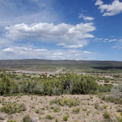
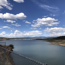
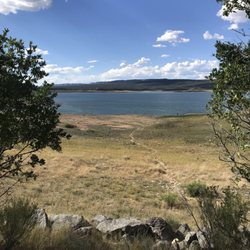
Monestary Lake Photos


More like Monestary Lake
Recommended Reviews - Monestary Lake
Start your review...

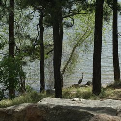
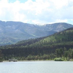
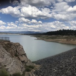
Easiest day trip everrrrr. We left Albuquerque around 7am, and pulled in around 8:10ish. We spent about 2 hours fishing at the lake, and then drove up a few miles and found a great chill spot to fish the river the rest of the day. This is a fishing only lake, no swimming or boating, no campfires or camping allowed. Fishing licenses are required for anyone 12 years or older (if you're fishing, of course), no license required to chill. They are open 30 minutes before sunrise to sunset, and there are portable toilets on site. Owned by the Benedictine monastery, public access is leased from the monastery by the NM Dept of Game and Fish through the Open Gate Program. There is a small dirt trail around the lake, and the lake itself covers six acres and is appx. 20 feet deep. The pond is regularly stocked, and provides good handicap access. It's a nice little spot, it wasn't crowded, even the day before 4th of July, and it was truly an enjoyable morning spent. read more


9 years ago
What a fun day to go fishing or for some outdoor enrichment! If you are in the Albuquerque or the surrounding area and interested in fishing or walking around the great outdoors, Monestary Lake is a nice day trip to go check out. The the best of catch spots but serene nonetheless. Of course there is no liquor or glass items but you can bring your dog for an on leash trail walking or food for a picnic. The lake itself is small and there is a larger crowd but enough space to have some privacy but you will hear the joy from others when they catch a fish! Located in the Pecos, as you continue from Monestary Lake there are other fishing opportunities. If you are day tripping or hitting up different fishing spots to your destination, check out Monestary Lakes! read more


More info about Monestary Lake
Monastery Lake Rd
Pecos, NM 87552
Directions
Hours
Outdoor Amenities


Monestary Lake - lakes - Updated July 2026
Best of Pecos
People found Monestary Lake by searching for…
Trending Searches in Pecos, NM
Beautiful Views near Monestary Lake
Fruit Picking near Monestary Lake
Kayak Rental near Monestary Lake
Lakes & Ponds near Monestary Lake
Off Road Trails near Monestary Lake
Outdoor Basketball Courts near Monestary Lake
Picnic Spots near Monestary Lake
Public Swimming Pools near Monestary Lake
River Swimming near Monestary Lake
River Tubing near Monestary Lake
Swimming Holes near Monestary Lake
Swimming Lakes near Monestary Lake
U Pick Farms near Monestary Lake
Watch Sunset near Monestary Lake
Browse Articles
Browse Brands
Related Searches in Pecos, NM
Affordable Kayak Rental Services in Pecos, New Mexico
Best Fishing Locations and Guides in Pecos, New Mexico
Best Places for Stunning Views in Pecos, New Mexico
Discover Lakes & Ponds to Explore in Pecos, New Mexico
Discover the Best Beaches in Pecos, New Mexico
Enjoy Kayaking Adventures in Pecos, New Mexico
Enjoy Tent Camping Spots Around Pecos, New Mexico
Enjoy Water Activities and Fun in Pecos, New Mexico
Enjoy the Best Walking Trails in Pecos, New Mexico
Experience Stunning Sunset Views in Pecos, New Mexico
Explore Beautiful Parks and Green Spaces in Pecos, New Mexico
Explore Easy Hikes Perfect for All in Pecos, New Mexico
Explore Fun Activities to Do in Pecos, New Mexico
Explore Parks With Lakes to Visit in Pecos, New Mexico
Explore Popular Campgrounds Near Pecos, New Mexico
Explore Popular Picnic Areas Around Pecos, New Mexico
Explore Popular RV Parks Around Pecos, New Mexico
Explore Top Marinas Near Pecos, New Mexico
Explore Top Water Parks in Pecos, New Mexico Today
Explore the Best Swimming Holes Around Pecos, New Mexico
Find Beautiful Views in Pecos, New Mexico
Find Top Dog Friendly Parks to Visit in Pecos, New Mexico
Find Top Dog Swimming Spots in Pecos, New Mexico
Find Top-Rated Waterfalls in Pecos, New Mexico Now
Find the Best Parks BBQ Grills in Pecos, New Mexico
Find the Best Parks for Picnics in Pecos, New Mexico
Find the Best Playgrounds to Visit in Pecos, New Mexico
Find the Best Swimming Pools in Pecos, New Mexico Today
Great Places to Swim in Pecos, New Mexico
Have Fun at a Splash Pad in Pecos, New Mexico
Hiking Trails With Waterfalls in Pecos, New Mexico
Plan a Scenic Drive Route Near Pecos, New Mexico
Popular Fishing Spots to Explore in Pecos, New Mexico
Popular Outdoor Activities to Try in Pecos, New Mexico
Popular Picnic Spots to Visit in Pecos, New Mexico
Relax at Natural Hot Springs Near Pecos, New Mexico
Safe Lakes for Swimming Near Pecos, New Mexico
Safe River Swimming Areas in Pecos, New Mexico
Safe and Fun Parks for Kids in Pecos, New Mexico
Top Fishing Ponds to Visit in Pecos, New Mexico
Top Hiking Trails to Explore in Pecos, New Mexico
Top Playgrounds for Kids to Enjoy in Pecos, New Mexico
Top Running Trails to Explore in Pecos, New Mexico
Top Swimming Lakes to Enjoy in Pecos, New Mexico
Top Swimming Spots and Pools in Pecos, New Mexico
Top-Rated Camping Sites in Pecos, New Mexico
People who viewed Monestary Lake also viewed
Santa Fe Canyon Interpretive Loop
2 reviews
Cerrillos Hills State Park
4 reviews
Picacho Peak
6 reviews
Atalaya Trail
15 reviews
Hillside Park
5 reviews
Rail Trail
4 reviews
Dorothy Stewart Trail
2 reviews
Randall Davey Cntr Audubon Society
6 reviews
General Franklin E. Miles Park
1 review
Arroyo Hondo Open Space
2 reviews