Cancel

    Open app

    Search

    Moose Mountain

    4.3 (3 reviews)

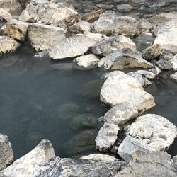
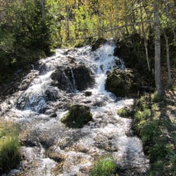
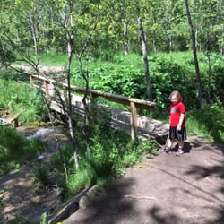
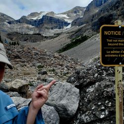
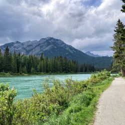
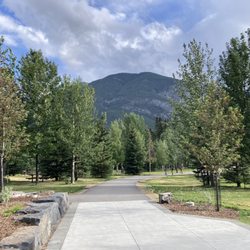
    Moose Mountain Photos

    Recommended Reviews - Moose Mountain

    Your trust is our priority, so businesses can't pay to alter or remove their reviews. Learn more about reviews.
    Yelp app icon
    Browse more easily on the app
    Review Feed Illustration

    3 years ago

    Helpful 1
    Thanks 0
    Love this 1
    Oh no 0
    Photo of Dale E.
    1286
    541
    2739

    10 years ago

    Helpful 7
    Thanks 0
    Love this 3
    Oh no 0
    Photo of Alan S.
    0
    106
    30

    7 years ago

    Helpful 0
    Thanks 0
    Love this 0
    Oh no 0

    Verify this business for free

    Get access to customer & competitor insights.

    Verify this business

    Troll Falls

    Troll Falls

    4.7(3 reviews)
    21.7 km

    A lovely, easy hike with a HUGE beautiful pay off at the end! It's a family friendly stroll with…read moreplenty of parking at the trailhead and it's easy to do in a couple of hours at most. The elevation is easy, and the stroll through the forest is leisurely and beautiful. In the winter you may want cramp ons or hiking poles since the packed down snow can get slick, but they're not necessary. At the end you'll find the beautiful Troll Falls. In the winter they're frozen the most miraculous bright blue and ice climbers have a great time climbing it's relatively easy verticals. Unlike the Johnston Canyon hike in Banff National Park, the Troll Falls hike allows you to get right up to the water falls, which makes for a truly special experience. Check my photos for proof!

    In the mountains and wanna go hiking, but need a spot that's not too difficult and also…read moreentertaining for wee kids? This is it. We were looking at different trail maps and unsure where to take our two year old for a hike that would grasp her attention span and also would be able to drag her along in a sled if she gets tired from all the walking. When Troll Falls popped out and had everything e were looking for. It's right at the bottom of the ski slope so if you find yourself driving up the mountain, you've gone too far. There is a decent sized parking lot by the entrance to the trail. The secret weapon for kids entertainment (aside from nature chats) are the hidden Troll Dolls around. Fun for everyone to try to be the first to spot them along the way! Even in December this was a fantastic crisp walk to do and at the end you come to a frozen waterfall. It was the most amazing thing to see, and to be able to walk on the frozen river. Just breathtaking! My husband is a geologist so he gives me all the geology chat along the way too. Really fantastic walk, I can't wait to do it again in summer and have a totally different experience. We seen a wolf run across the main road as we drove down to the trail so remember to stay safe when you are out there!

    Photos
    Troll Falls - Spot the troll dolls

    Spot the troll dolls

    Troll Falls
    Troll Falls

    See all

    Kootenay National Park - Stanley Glacier Hike

    Kootenay National Park

    4.7(15 reviews)
    79.7 km

    We had an amazing time visiting sites in Kootenay National Park while staying in Radium Hot Springs…read morefor a week. The is such a picturesque part of British Colombia, Canada. Our first stop was Olive Lake. A gorgeous green-blue body of water. A short trail from the parking lot. Our next stop was Paint Pots. Such a cool experience. We've never seen anything like it before. The colorful, iron-rich pools were so cool to see up close. The boardwalk to the paint pots was picturesque too. There are many stops and viewpoints along highway 93. Be sure to stop at the ranger station to get your park pass ($14/day) and map of all stops along the route. Most stops have restrooms available as well. Overall a must while visiting British Colombia, Canada. We thoroughly enjoyed exploring this area and would highly recommend.

    Rumor had it that Kootenay National Park was, perhaps, the most underrated of the National Parks in…read morethe area. I'm all for supporting the underdogs (& avoiding the crowds). Compared to Banff, Kootenay was empty & there are plenty of bodies of Gatorade-like waters. We enjoyed the wide open spaces and the non-touristy vibe of the park. On our Stanley Glacier Hike, we only saw 3 other sets of people... no shoulder bumping or shuttles needed here. We opted for the annual family/group pass, a great value if you're spending a week or so in any combination of the parks &/or may come back. (& we will come back... already planning it)

    Photos
    Kootenay National Park - Stanley Glacier Hike

    Stanley Glacier Hike

    Kootenay National Park - Stanley Glacier Hike

    Stanley Glacier Hike

    Kootenay National Park - This is the Continental Divide sign starting out Kootenay NP near the Banff area.

    See all

    This is the Continental Divide sign starting out Kootenay NP near the Banff area.

    Prairie Mountain

    Prairie Mountain

    5.0(1 review)
    13.0 km

    This was an intense hike with a steep learning curve! (haha…read moresee what I did there? ) This place was a lot easier to find than I thought it would be, thank goodness! Basically head down Hwy 66 until you come to winter closure gates. When the gates are closed you can park on the side of the road, with several trailhead options right beside the road. They all meet up to the main trail so we took the one past the gates. It's pretty much like hiking Vancouver's Grouse Mountain - a ~700m gain thigh-burning grind of a ~3km climb straight to the summit! And being that we live in Alberta, I tend to forget mountains have an entirely separate agenda when it comes to weather, regardless of what season it currently is on ground level lol. It was spitting rain when we started our hike about 9:30am, which slowly turned to sleet after 20-30 minutes up the trail, until finally snowing a little further up Thank god I had a random poncho hiding in my car, because I was ill-prepared for snow! With leftover winter still gripping the mountains, it was a little difficult without spikes for traversing the snowy bits, but I managed with great trail runners haha. As we got past the tree line towards the summit, it turned into a complete whiteout of hard snow/sleet pelting against our faces! The flagpole at the top still stands though, with the little thrashing about in the strong winds! It's a great view from up there, as you can see from the pictures lol. I must say the way back down was ridiculous fun, sliding down snow, bouncing between trees for braking and running down the mud! I am definitely coming back to actually see the majestic valley view without snow!

    Photos
    Prairie Mountain - ...now snowing!

    ...now snowing!

    Prairie Mountain
    Prairie Mountain

    See all

    Mountain Yamnuska Hike

    Mountain Yamnuska Hike

    5.0(1 review)
    26.7 km

    That was fun! Scary... but fun! This is a good and fun hike/scramble, including some adrenaline…read more But it is not an easy hike. So if you are scared of heights and not in a decent shape, don't do it! If you are uncertain about your capabilities I recommend going up Ha Ling peak. If you have no problems doing this hike and the gravel at the summit (yes, I want you to go all the way up) doesn't scare the shit out of you, you are probably fine to climb Yamnuska. Don't get me wrong, I don't want to talk you out of doing this hike. I just want you to be cautious. There are many situations during this hike where you really need to watch your step. If you misstep or lose balance, you can seriously hurt yourself. And if your legs get too tired it's very easy to lose your balance! Same goes for being on the phone, so don't text and hike! The mountain can be seen from the TC highway. It has a wide 152m cliff face (facing south) that is very popular with local rock climbers. Start at the end of the parking lot. There is an information sign you should read, about where to go and where not (!) to go, take a picture of the map. The path starts right there, next to the sing. After walking for a bit you come to a sign that tells climbers to go left and hikers to go right. Go right, which means you go counter-clockwise, it's easier. Follow the yellow square signs. Further up it will be blue squares. When you are close to the top there will be various different ways you can go up, just pick the one that looks the best to you. The view at the summit and on the way up is stunning, enjoy it. At one point you have to climb along a rock with very little overhang you can stand on. That's why they have a chain there you can hold on to. Don't worry, it looks much scarier than it is. On your way down there will be a lot of gravel. Choose the areas where the gravel is deep and you sink in, this is the easiest to go down. Sinking in makes you stop, it is almost like going down stairs. Light gravel will make you slide down and fall. But again, remember what the information sign said about where not to go! They say the elevation gain is 900 meters, my app showed 1076 meter and my fitbit said I did 330 floors... pick you poison. What to bring: - Good hiking boots, preferably with ankle support - Gaiters, so you don't end up with too much gravel in your boots - Hat - Poles sometimes come in handy - Lots (!) of water - Phone to take pictures (but you better not drop it) - Sunscreen and bug spray Don't worry too much about all the things that could happen on this hike. If you worry too much you get insecure and then very likely something is going to happen. Many people are doing this hike, just watch your step and be careful. Have fun!!

    Photos
    Mountain Yamnuska Hike - So scenic

    So scenic

    Mountain Yamnuska Hike
    Mountain Yamnuska Hike - Now the climbing and scrambling begins

    See all

    Now the climbing and scrambling begins

    Soul Ski & Bike - New Nórdica skis, great deal on last year's model!

    Soul Ski & Bike

    4.5(11 reviews)
    57.8 km
    $

    DUDE. I went into basically every ski shop in Banff and this was the place that I knew I had to buy…read morefrom. Andrew, the owner, took time to listen and ask questions about my ability, my preferences, and what I needed to work on. He gave me advice without trying to sell me on anything - very different than some of the other shops in town (cough, cough, Abominable). I decided on some skis and wanted to work out some boot issues I'd been having. He told me to come back the next day and Brody would help me out (because Andrew was going out of town). Brody = freaking amazing. I ended up getting new boots and he helped me figure out that I was in a boot way too big for me. I got the new boots and after a day of riding, came back to make some adjustments. He and Tristan really thought through what options I had to make the boot fit perfectly. I was so impressed with how cool Brody was with my MILLIONS of questions. You could tell that he really cared about doing things right and making sure I felt great in my boots. It was an awesome experience. They do heat molding, waxing/tuning, sell Nórdica, K2, and Technica (and a few other brands I think). Great shop with great people! We meant to stop by to say thanks again before we left but didn't have time - if you see this review, tell them Andrea from Las Vegas sent you!

    This was my first time renting bikes in banff. We wanted a more relaxed ride so we could explore…read morethe town of the banff and the bow river. We opted for cruiser bikes. The staff were friendly and eager to help. We received a helmet and a lock along with your bike, charging you 10 bucks for an hour or if, over 3.5 hours, it'll be 35 for the day. We found these to be pretty reasonable prices! The bikes were comfy and easy to use. There were also lots of trails and places to bike around town that could allow you the whole day to explore. We would definitely come back here. Maybe next time I'll try a mountain bike!

    Photos
    Soul Ski & Bike
    Soul Ski & Bike
    Soul Ski & Bike - Our rental bikes!

    See all

    Our rental bikes!

    Moose Mountain - hiking - Updated June 2026

    Loading...
    Loading...
    Loading...