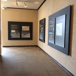
Moses Lake Information Center Photos


More like Moses Lake Information Center
Recommended Reviews - Moses Lake Information Center
Start your review...

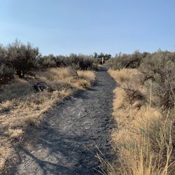
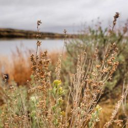
This is a really cute park to stop and have lunch or just sit and chill out. There is quite a bit of parking and if you're one that is just passing by Moses Lake, there is a public bathroom to stop and get rid of some lemonade. There is a cool fountain as you enter the information center/rest area and then plenty of picnic tables lined up to sit down and eat. It would be nice if there were some umbrellas or something to shield from the strong sun, but the only time you'll probably get sun is in the summer anyway because let's be real....this is Washington. Eastern Washington is a bit different though, but I still wish there was some sort of coverage from the sun. There are no trees either. I also thought it was cool that they have an electric car powering station, so that could be cool if you need to stop and charge up your e-car. This information center is basically in the middle of downtown so it has great access to all the festivities and restaurants and goings-on of the downtown area. I'm just glad they had a bathroom because I really needed one. read more


More info about Moses Lake Information Center


Moses Lake Information Center - landmarks - Updated July 2026
Best of Moses Lake
People found Moses Lake Information Center by searching for…
Parks in Moses Lake, Washington
Things to Do in Moses Lake, Washington
Places to Take Pictures in Moses Lake, Washington
Attractions in Moses Lake, Washington
Places to Visit in Moses Lake, Washington
Picnic Areas in Moses Lake, Washington
Public Services & Government in Moses Lake, Washington
Things to See in Moses Lake, Washington
Festivals in Moses Lake, Washington
Photo Spots in Moses Lake, Washington
Tourist Attractions in Moses Lake, Washington
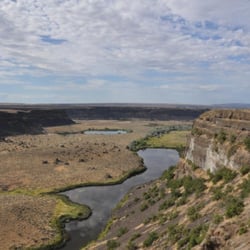
Scenic View in Moses Lake, Washington
View Points in Moses Lake, Washington
Sightseeing in Moses Lake, Washington
Night View in Moses Lake, Washington
Arts & Entertainment in Moses Lake, Washington
Bathroom in Moses Lake, Washington
What to Do in Moses Lake, Washington
Landmarks in Moses Lake, Washington
Picnic Spots in Moses Lake, Washington
Scenic Overlook in Moses Lake, Washington
Field Trips in Moses Lake, Washington
Trending Searches in Moses Lake, WA
Boat Rental near Moses Lake Information Center
Day Trips near Moses Lake Information Center
Fireworks near Moses Lake Information Center
Jet Ski Rental near Moses Lake Information Center
Kayak Rental near Moses Lake Information Center
Landmarks & Historical Buildings near Moses Lake Information Center
Picnic Areas near Moses Lake Information Center
Places To Swim near Moses Lake Information Center
Places To Visit near Moses Lake Information Center
River Swimming near Moses Lake Information Center
Splash Pad near Moses Lake Information Center
Strawberry Picking near Moses Lake Information Center
Swimming Holes near Moses Lake Information Center
Swimming Lakes near Moses Lake Information Center
Things To See near Moses Lake Information Center
Browse Articles
Browse Nearby
BEST of Moses Lake, Washington Restaurants near Moses Lake Information Center
BEST of Moses Lake, Washington Coffee near Moses Lake Information Center
BEST of Moses Lake, Washington Things to Do near Moses Lake Information Center
BEST of Moses Lake, Washington Photo Spots near Moses Lake Information Center
BEST of Moses Lake, Washington Breakfast near Moses Lake Information Center
BEST of Moses Lake, Washington Museums near Moses Lake Information Center
BEST of Moses Lake, Washington Hotels near Moses Lake Information Center
BEST of Moses Lake, Washington Campgrounds near Moses Lake Information Center
BEST of Moses Lake, Washington Day Trips near Moses Lake Information Center
Browse Brands
Related Searches in Moses Lake, WA
Best Fishing Locations and Guides in Moses Lake, Washington
Best Fun Things to Do in Moses Lake, Washington
Best Lookout Points to Visit in Moses Lake, Washington
Best Nature Trails for Hiking in Moses Lake, Washington
Best Places for Stunning Views in Moses Lake, Washington
Best Spots for Star Gazing in Moses Lake, Washington
Best Waterfalls and Swimming Holes in Moses Lake, Washington
Discover Charming Historic Homes in Moses Lake, Washington
Discover Famous Monuments in Moses Lake, Washington
Discover Fun Kid Activities to Enjoy in Moses Lake, Washington
Discover Historic Sites and Places in Moses Lake, Washington
Discover Popular Photo Spots in Moses Lake, Washington
Discover Romantic Views in Moses Lake, Washington
Discover Top Nature Parks to Visit in Moses Lake, Washington
Discover the Best Beaches in Moses Lake, Washington
Discover the Best Caves to Explore in Moses Lake, Washington
Enjoy Arts & Entertainment in Moses Lake, Washington
Enjoy Hiking Adventures in Moses Lake, Washington
Experience Stunning Sunset Views in Moses Lake, Washington
Experience the Best Family Fun in Moses Lake, Washington for All
Explore Beautiful Castles and Landmarks in Moses Lake, Washington
Explore Beautiful Parks and Green Spaces in Moses Lake, Washington
Explore Fun Activities to Do in Moses Lake, Washington
Explore Popular Scenic Overlook Points in Moses Lake, Washington
Explore Scenic Lakes to Visit in Moses Lake, Washington
Explore Secret Spots Worth Visiting in Moses Lake, Washington
Explore Sunday Fun Things to Do in Moses Lake, Washington
Explore Top Art Galleries Located in Moses Lake, Washington
Explore Venues & Event Spaces in Moses Lake, Washington
Find Beautiful Views in Moses Lake, Washington
Find Top Libraries to Visit in Moses Lake, Washington
Find Top-Rated Waterfalls in Moses Lake, Washington Now
Find the Best Bridge Spots in Moses Lake, Washington
Find the Best Playgrounds to Visit in Moses Lake, Washington
Fun Indoor Activities to Try in Moses Lake, Washington
Must-See Tourist Attractions Around Moses Lake, Washington
Popular Kids Activities in Moses Lake, Washington
Popular Places to Take Pictures in Moses Lake, Washington
Popular Places to Walk Around in Moses Lake, Washington
Popular Things to Do in Moses Lake, Washington
Popular Things to See in Moses Lake, Washington
Relax at Natural Hot Springs Near Moses Lake, Washington
Secure Convenient Parking Options in Moses Lake, Washington
Top Entertainment Options in Moses Lake, Washington
Top Fun Things to Do at Night in Moses Lake, Washington
Top Hiking Trails to Explore in Moses Lake, Washington
Top Historic Restaurants to Try in Moses Lake, Washington
Top Places to Visit in Moses Lake, Washington for Sightseeing