Cancel

    Open app

    Search

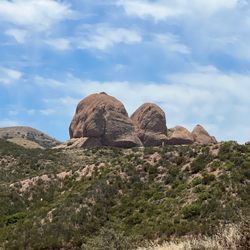
    Mount McDill

    4.0 (1 review)

    Mount McDill Photos

    You might also consider

    Recommended Reviews - Mount McDill

    Your trust is our priority, so businesses can't pay to alter or remove their reviews. Learn more about reviews.
    Yelp app icon
    Browse more easily on the app
    Review Feed Illustration
    Photo of Brian U.
    0
    2129
    128

    4 years ago

    Helpful 0
    Thanks 0
    Love this 0
    Oh no 0

    You might also consider

    Verify this business for free

    People searched for Hiking 1,099 times last month within 15 miles of this business.

    Verify this business

    Grass Mountain

    Grass Mountain

    4.5(2 reviews)
    5.7 mi

    I stopped celebrating New Year's Eve years ago because of the loud fireworks that affected all my…read morepets, and started a tradition of exploring a new trail every January 1st with my pups. This year, we headed toward Lake Elizabeth and began exploring the canyon trails. These trails were perfect! We started on Forest Road, right by the lake, and got onto Pacific Crest Trail. The trails are slightly bumpy in some spots and sandy in others, but overall, it wasn't too rough for my dogs. We spent about 1.5 hours trail driving before stopping for a hike. It was incredibly quiet, safe and peaceful. Some areas of the trail are quite narrow, but others have extra space to park and enjoy the view. It's a fantastic spot for hiking, off-road driving, and a picnic. The views of the mountains and lake are beautiful ! This review is not specific to the Grass Mtn but it is in this area and these trails will get you there. I loved this trail, will definitely be back and recommend it for any outdoor or off-road enthusiast. Happy New Year, everyone!

    The shortest path to Grass Mountain is via the Pacific Crest Trail. The starting point is 0.6 miles…read moresouth of San Francisquito Canyon Pass on San Francisquito Canyon Road. We didn't take this route. Instead, we opted for the slightly longer and less steep version that starts at San Francisquito Canyon Pass where Leona Divide Fire Road intersects then heading 2.8 miles northwest with a 900' elevation change. Getting to the top is easy to follow due to the eponymous grassy field, pine and juniper trees, and cell towers at the summit. The buried power line in the road is another clue due to dozens of Edison pull boxes in the trail and the separate fire break that the soft and sandy road skirts. The wide fire break and unground electrical conduit shows a major effort to limit forest fires in this area. Perhaps authorities are being extra cautious to avoid another disaster in the same canyon where the St. Francis dam collapsed in 1928 resulting in 400+ fatalities. The treeless trail meant repeated views of the wind farms in the western Antelope Valley and San Francisquito Canyon with the town of Green Valley as the centerpiece. I'm interested in going back in the spring to see if color patches of the Antelope Valley Poppy Reserve are visible. The peak was windy on our visit which I'd guess that is common. An unexpected bonus were the uplifted rock formations where the bulldozing that created the road exposed swirls of sedimentary layers. The open gate allowed access for vehicles to drive to Grass Mountain but passing could be tricky since the road is mostly the width of one big truck. We crossed paths with only one pickup truck which meant for a peaceful and undusty hike. Just barely within the boundary of the Angeles National Forest, a $5 Adventure Pass (or equivalent) is customary when parking on National Forest land.
    Photos
    Grass Mountain
    Grass Mountain - Quick stop with my favorite girl.   This trail is amazing for light off-road 4x4 fun with your pet.

    Quick stop with my favorite girl. This trail is amazing for light off-road 4x4 fun with your pet.

    Grass Mountain

    See all

    Martindale Ridge via Rowher OHV - big rick in the trail

    Martindale Ridge via Rowher OHV

    4.5(2 reviews)
    3.6 mi

    There are a lot of trails out here. Some are just for atvs and bikes. And you have to be careful,…read morebecause many of the trails have black diamond offshoots that can mess you up if you're. it careful, or at least prepared. lovely place.

    Although COVID cancelled our hikes overlooking Lake Tahoe, we tried Bouquet Canyon reservoir as a…read moresubstitute. Granted, not an equal replacement but was still enjoyable with multiple vistas of the man-made lake and a few patches of wildflowers. We started at Forest Road 6N08 and Bouquet Canyon Road along the eastern edge of the reservoir and just kept going up until we reached the top of Martindale Ridge. The ridge is also accessible from opposite side via Sierra Highway near Agua Dulce. Not an area of the Angeles National Forest where environment concerns are at the forefront, the roads are legal for Off-Highway Vehicle (OHV) use like dirt bikes, ATVs, and 4-wheelers. We were the only hikers on the dirt roads which we safely shared with six motorcyclists and a dozen 4x4s. As with most off-roading areas, multiple tracks were cut through the mountains. The trails were either named Martindale Ridge Road or Rowher OHV Trail. Consequently, it's easy to confuse the two and depending on the route taken, distances can greatly vary. For example, we hiked 5.0 miles going up and 3.8 miles returning down. The entire hike was 8.9 miles with a 1700' elevation difference.

    Photos
    Martindale Ridge via Rowher OHV - Sign up close

    Sign up close

    Martindale Ridge via Rowher OHV - Another big rock

    Another big rock

    Martindale Ridge via Rowher OHV - Lovely

    See all

    Lovely

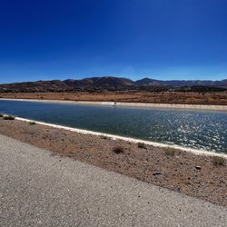
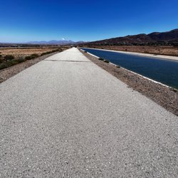
    Palmdale Aqueduct - The California Aqueduct near Palmdale

    Palmdale Aqueduct

    4.9(8 reviews)
    4.7 mi

    I don't know that most Los Angelinos know how much effort and engineering goes into bringing their…read morewater to them. These canals and tunnels and pipelines bring water 444 miles from the Sierra Nevada Mountains to Southern California. The Edmund G. Brown (a former California Governor) "California Aqueduct" is the state's largest and longest water transport system It was initially sold to the public in 1960 for an estimated total cost of $1.75 billion in state bonds. This was a misleading and low-balled figure. Construction began in 1961 and though still incomplete, the total cost for the project has grown over $4.3 billion for twenty-five dams and reservoirs, eighteen pumping plants, 683 miles of aqueducts, and eight hydro-electric power plants. The aqueduct serves 35 million people and 5.7 million acres of farmland pumped along the way to overcome gravity here and there through pumping stations and some of that energy is later recovered by hydroelectric plants. For example, the Edmonston Pumping Plant raises the water 1,926 feet over the Tehachapi Mountains. Much of the aqueduct walkways and bikeways were closed after September 11, but here in Palmdale where the Pearblossom Highway crosses over, there is a parking area and a narrow fenceway opening that you can fit through. I don't know that a bicycle would make it. It's worth stopping to see this tremendous engineering feat and perhaps understand what happens before you water your lawn or fill your pool. [Review 17536 overall - 333 in California - 1054 of 2022.]

    I went today for a walk and the views are absolutely gorgeous! It was cold but it was a nice quiet…read morewalk.

    Photos
    Palmdale Aqueduct - Beautiful Day for 28 miles

    Beautiful Day for 28 miles

    Palmdale Aqueduct - The California Aqueduct near Palmdale

    The California Aqueduct near Palmdale

    Palmdale Aqueduct - The California Aqueduct near Palmdale

    See all

    The California Aqueduct near Palmdale

    Kern River Outfitters - Kern Glamping Tents

    Kern River Outfitters

    4.9(360 reviews)
    77.9 mi

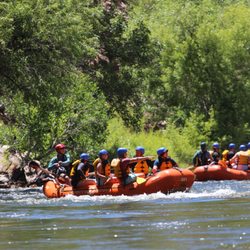
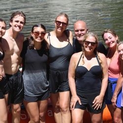
    We had a BLAST rafting with Kern River Outfitters. We were a party of 12 with kids ranging in age…read morefrom 10-15 plus adults and the whole experience was perfect for all ages! The guides were exceptional - we were led by Jackson and our guides on the rafts were Scott and Anneke. They gave us all of the important safety information (in a fun, engaging way) and once we were on the rafts they gave us clear direction (forward 1! Back 1!), talked about the rapids and local points of interest while making the trip super fun for everyone. The first time down the rapids helped our group get comfortable with what to expect. And on the second trip down the fun really increased! They let the kids "ride the bull" and get silly (all while feeling super safe!). We're planning to come back for a 2- day trip once all of our kids are old enough. Highly recommend!!!

    If you're looking for a great time, this is the place! Get going while the river water is flowing!…read more This place has great guides and they put your safety first. I went for a full day of rafting and it was great. We rode the upper Kern. The cold water felt great on such a hot day. John was our guide. He was great. You'll have a great time with any of the guides! They're all really fun. It would have been great to be able to jump off your raft and swap to another raft just for fun. The lunch provided was not bad. Sandwiches, cookies, fruit, and lemonade. Definitely would come back to raft with them again!

    Photos
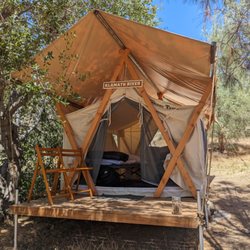
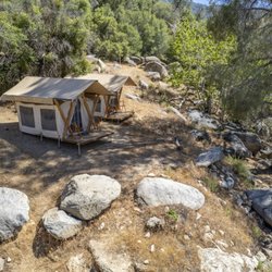
    Kern River Outfitters - Riverside Glamping

    Riverside Glamping

    Kern River Outfitters
    Kern River Outfitters

    See all

    Mount McDill - hiking - Updated May 2026

    Loading...
    Loading...
    Loading...