Nokiidaa Tail - Green Lane Photos


 - Hiking Near Me - Newmarket, Ontario")
More like Nokiidaa Tail - Green Lane
Recommended Reviews - Nokiidaa Tail - Green Lane
Start your review...

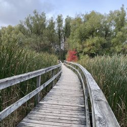
We came here to see the fall colours. As of Oct 12, 2025, we were a little early but there were still some fully turned trees. When the sun came out, the colours really shone through. Nice patch of nature in the middle of a suburban neighbourhood. There's streams, ponds, and plenty of trees. Lots of birds and squirrels. Also signs here and there explaining trees and flowers. Mostly paved and flat, so the trail seems quite accessible. Depending on how you do the loop, you could spend 30min to 2.5hr in the park. There are also quite a few parking spots around the trail, so park near where you'd like to enter. If you make the wrong turn, you'll find yourself by a busy road, so check googlemaps as you go and stay in the park. The park is also on All Trails. read more


Sunday May 9, 2021 - My friends decided to go for a walk. When I asked where are we going, they said to drop me off and leave me so that I can walk home. LOL .. it's a 9.5hr walk to home from there *cries*. We walked along the trail from Green Lane E to Yonge St. It took about 2.5 hours to go and come. We stopped here and there took photos and rested. It's a really nice trial to walk and there where off trail areas for biking. There was also some nice areas to sit and relax. read more


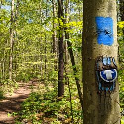
Looking for nature in your backyard? Check out the various sections of the Nokiidaa trail. With abundance of free parking off of Green Lane this is the perfect place to start your adventure. Travel north and see the award winning 2nd Concession boardwalk and sections of the Holland River Canal meandering through shaded forest canopy. To the south you will meet up with Newmarket and historic Main Street as you travel towards Aurora. If you are walking, cycling, or out for a run, this trail system spanning Aurora, Newmarket, and East Gwillimbury has something for you. See you on the trail. ;-) read more


More info about Nokiidaa Tail - Green Lane
868 Green Lanen E
Newmarket, ON L3X 0A4
Canada
Directions
Hours
Outdoor Amenities


Why does Yelp recommend reviews?
1 review that is not currently recommended
The reviews below are not factored into the business's overall star rating.
3 years ago
Nokiidaa Tail - Green Lane - hiking - Updated July 2026
People found Nokiidaa Tail - Green Lane by searching for…
Fun Things to Do in Newmarket, Ontario
Hiking Trails in Newmarket, Ontario
Playgrounds in Newmarket, Ontario
Walking Trails in Newmarket, Ontario
Waterfall Hike in Newmarket, Ontario
Beautiful Views in Newmarket, Ontario
Running Trails in Newmarket, Ontario
Free Parking in Newmarket, Ontario
Walking Groups in Newmarket, Ontario
Mountain Biking in Newmarket, Ontario
Fun Things to Do on Your Birthday in Newmarket, Ontario
Places to Visit in Newmarket, Ontario
Free Things to Do in Newmarket, Ontario
Off Road Trails in Newmarket, Ontario
Lakes & Ponds in Newmarket, Ontario
Things to Do Alone in Newmarket, Ontario
Fun Things to Do on a Saturday Night in Newmarket, Ontario
Places to Take Pictures in Newmarket, Ontario
Natural Hot Springs in Newmarket, Ontario
Tent Camping in Newmarket, Ontario
Dog Friendly Things to Do in Newmarket, Ontario
Browse Articles
Browse Brands
Related Searches in Newmarket, ON
Affordable Kayak Rental Services in Newmarket, Ontario
Best Fishing Locations and Guides in Newmarket, Ontario
Best Fun Things to Do in Newmarket, Ontario
Best Off Leash Dog Parks in Newmarket, Ontario
Best Places for Horseback Riding in Newmarket, Ontario
Best Places for Stunning Views in Newmarket, Ontario
Best Sledding Spots and Fun in Newmarket, Ontario
Discover Kid Friendly Hiking Trails in Newmarket, Ontario
Enjoy Camping Adventures Around Newmarket, Ontario
Enjoy Exciting Mountain Biking Adventures in Newmarket, Ontario
Enjoy the Best Family Activities in Newmarket, Ontario
Enjoy the Best Tubing Experiences in Newmarket, Ontario
Enjoy the Best Walking Trails in Newmarket, Ontario
Exciting Cliff Jumping Spots in Newmarket, Ontario
Explore Beautiful Parks and Green Spaces in Newmarket, Ontario
Explore Bike Rentals Throughout Newmarket, Ontario
Explore Free Things to Do Around Newmarket, Ontario
Explore Fun Activities to Do in Newmarket, Ontario
Explore Nature Spots Around Newmarket, Ontario
Explore Popular Campgrounds Near Newmarket, Ontario
Explore Popular View Points Around Newmarket, Ontario
Explore Scenic Lakes to Visit in Newmarket, Ontario
Explore Top Dog Parks in Newmarket, Ontario Near You
Explore Top Water Parks in Newmarket, Ontario Today
Explore the Best Boating Spots in Newmarket, Ontario
Explore the Best Trail Options in Newmarket, Ontario
Find Beautiful Views in Newmarket, Ontario
Find Fun Things to Do With Kids in Newmarket, Ontario
Find Popular Ziplining Spots Around Newmarket, Ontario
Find Top Dog Swimming Spots in Newmarket, Ontario
Find the Best Playgrounds to Visit in Newmarket, Ontario
Find the Best Scenic View Locations in Newmarket, Ontario
Hiking Trails With Waterfalls in Newmarket, Ontario
Plan a Scenic Drive Route Near Newmarket, Ontario
Popular Fishing Spots to Explore in Newmarket, Ontario
Popular Kids Activities in Newmarket, Ontario
Popular Outdoor Activities to Try in Newmarket, Ontario
Popular Picnic Spots to Visit in Newmarket, Ontario
Popular Things to Do in Newmarket, Ontario
Popular Things to See in Newmarket, Ontario
Safe and Fun Parks for Kids in Newmarket, Ontario
Top Climbing Spots and Gyms in Newmarket, Ontario
Top Paddleboarding Activities in Newmarket, Ontario
Top Places for Snorkeling in Newmarket, Ontario
Top Playgrounds for Kids to Enjoy in Newmarket, Ontario
Top Running Trails to Explore in Newmarket, Ontario
Top Swimming Lakes to Enjoy in Newmarket, Ontario
Top Swimming Spots and Pools in Newmarket, Ontario
People who viewed Nokiidaa Tail - Green Lane also viewed
Thornton Bales Conservation Area
5 reviews
East Don Parkland
6 reviews
Bayview Village
Mill Pond Park
24 reviews
Maple Nature Reserve
3 reviews
Toogood Pond
41 reviews
Unionville
Milne Dam Conservation Park
10 reviews
Unionville
Boyd Conservation Area
8 reviews
Pine Grove
Bob Hunter Memorial Park
5 reviews
Box Grove
Sugarbush Heritage Park
2 reviews
Thornhill Woods
Lake Wilcox Park
25 reviews