Palomarin Beach Photos


You might also consider
More like Palomarin Beach
Recommended Reviews - Palomarin Beach
Start your review...

2 years ago
Main trail is COMPLETELY overgrown. Heed the sign and don't take the main trail down. There is a shorter, steeper trail by the south parking lot but they both require the use of a rope ladder to get down the final 15 feet. Rather shaky on the way up. Just above the rope ladder there is another section of rope to help you ascend to where you can walk again. (Go right, not left.) The beach itself is very picturesque--lots of bluffs, a few small waterfalls, and a few sandy sections but mostly rocks. The tide pools I noticed were pretty small, probably not worth the journey especially if you have any gear with you (see above re: rope ladder). It is slow going walking along the rocks and seaweed, but it is a rather long beach. In my two hours there I saw NOBODY. read more
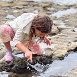
Simply put, I just love this beach! It's an amazing reward to be graced with the shallow waves of Palomarin Beach after embarking on a 4.5 mile hike and a short rock climb down the embankment. I've been to this beach a few times now so far, and its' beautiful views and calming waves never cease to amaze me. Palomarin Beach is located within Alamere Falls Park which is a subsidiary of Point Reyes National Seashore. This beach is only accessible through a few hiking trails within Alamere Falls Park. The shortest way to get to this beach is to take the Palomarin Beach Trail via the Palomarin/Coast Trail. This trail measures .6 miles one way, and will lead you directly down to the beach. If taking this trail, you'll have to scale down some steep rocks and cliffs. It's not impossible, but you'll need to have some upper body strength to climb up and down the rocks. If you've never been here before, I would suggest coming with someone just in case you need help getting up and down the steep cliffs. If you're not into rock climbing but don't mind the trek of a long hike, you can take the Palomarin (Coast) Trail all the way down to the beach. There's no rock climbing involved on this trail, however it's 6.5 miles one way. My favorite way to get down to this beach is via the Alamere Falls Trails. Not only does this trail take you down to the beach, but it also leads to the beautiful Alamere Falls! The hike to Alamere Falls is about 4.5 miles one way. You'll take the Palomarin Trail to Alamere Falls trail and it will lead you right down the beach. Like the Palomarin Beach Trail, this trail will involve some rock climbing down steep cliffs and rocks and you'll also have to hike through a short narrow path that contains poison oak and poison ivy. Totally doable as long as you're prepared for it. What's so great about this beach is that since it's located below the cliffs, it provides an amazing view of the California coastline, Every view will be picture worthy. The tides were low during my last visit, but they change depending on the season. You can put your feet in, but the waves can be pretty ferocious, so I wouldn't recommend swimming. The water is so white and clear and the sand is soft on your feet, so walking along the beach is perfect. There are a couple of flat rocks beneath the cliffs that are shaded. It's a nice place to sit and have lunch if you bring it with you. I will warn that the trail to the beach is a very popular one. So, if you want to beat the crowd, coming early is your best bet. Either way, this beach is totally worth a visit, especially if you're planning on hiking to Alamere Falls. read more


GETTING THERE. From the East Bay (Oakland, Berkeley, Alameda), San Raphael, or Fairfax, the easiest route is likely driving west on Sir Francis Drake Boulevard until you reach Olema, then turn south and continue south until you reach Olema Bolinas Road, which takes you along the west side of Bolinas Lagoon. Then, shortly before you reach the village of Bolinas, take a right turn (to the north) on Mesa Road. Mesa Road takes you all the way to Palomarin Trailhead. TA-DAAAAH ! (My recommended route avoids taking Route One through the Tamalpais Valley area, which has several hairpin curves, and scary cliffs. The scary cliffs are on the downhill side of Route One.) CLAM CHOWDER. After your visit to Palomarin Beach, I highly recommend stopping at one of the cafes or delis in Bolinas, such as Coast Cafe or Bovida Bolinas, for coffee and clam chowder. THE WALK DOWN. From Palomarin Trailhead, the hike down to the beach takes about 10 minutes. The scenery is lush with abundant greenery, and the devoted shutterbug will likely get distracted by the photo-opportunities. The final 30 seconds of the hike requires a slow descent down a steep slope. There is a 15-foot steep slope where you need to let yourself down while clutching a thick rope. This rope is tied to a bush. While letting yourself down, the slope is sufficiently angled, and with bumps of hard earth sticking out, so that you can place your feet on the bumps and ease yourself down while facing the cliff. THE BEACH. The beach has two zones, an area like a platform made of stone and a STONEY-ZONE that contains millions of stones. All of the stones are smooth, due to the decades and decades of polishing by being bumped together with the movement of the tides. The area that is like a stone platform has channels in. These channels it hold tidal pools, and kelp, tiny crabs, and other little sea animals live in these channels. In the STONEY-ZONE, if you walk south for a few minutes, or north for a few minutes, each of these two walks will take you past at least a half-million stones (there are no plants and not much sand in the STONEY-ZONE). My goal was to find a few stones that had a mouth and eyes. The technical term for clouds, mountains, or stones, that look like a human face or that look like an animal is: PAREIDOLIA. After a few visits to Palomarin Beach during the past eight years, I found five stones that were good enough for painting. I used enamel to paint eyes in the smoothly-sculpted naturally-occurring eye sockets. Also, I painted freckles on one of the stones. Another of the stones had naturally-occurring freckles. On each of my visits, I admired the large hawks that were flying above the cliffs situated at the eastern edge of the STONEY-ZONE. read more


More info about Palomarin Beach
You might also consider


Palomarin Beach - beaches - Updated July 2026
Best of Bolinas
People found Palomarin Beach by searching for…
Trending Searches in Bolinas, CA
Beach Chair Rentals near Palomarin Beach
Blueberry Picking near Palomarin Beach
Boardwalk near Palomarin Beach
Cliff Jumping near Palomarin Beach
Crabbing Location near Palomarin Beach
Day Trips near Palomarin Beach
Dog Friendly Beaches near Palomarin Beach
Jet Ski Rental near Palomarin Beach
Kayak Rental near Palomarin Beach
Peach Picking near Palomarin Beach
Picnic Spots near Palomarin Beach
Places To Swim near Palomarin Beach
Pool Day Pass near Palomarin Beach
Public Beaches near Palomarin Beach
River Swimming near Palomarin Beach
River Tubing near Palomarin Beach
Salt Water Pool near Palomarin Beach
Snorkeling near Palomarin Beach
Soccer Store near Palomarin Beach
Swimming Holes near Palomarin Beach
Swimming Lakes near Palomarin Beach
Tide Pools near Palomarin Beach
U Pick Farms near Palomarin Beach
Browse Articles
Browse Nearby
BEST of Bolinas, California Restaurants near Palomarin Beach
BEST of Bolinas, California Coffee near Palomarin Beach
BEST of Bolinas, California Tide Pools near Palomarin Beach
BEST of Bolinas, California Things to Do near Palomarin Beach
BEST of Bolinas, California Vacation Rentals near Palomarin Beach
BEST of Bolinas, California Breakfast near Palomarin Beach
BEST of Bolinas, California Lakes near Palomarin Beach
BEST of Bolinas, California Resorts near Palomarin Beach
BEST of Bolinas, California Campgrounds near Palomarin Beach
Browse Brands
Related Searches in Bolinas, CA
Affordable Paddle Board Rental in Bolinas, California
Affordable Snorkel Rental Services in Bolinas, California
Best Off Leash Dog Parks in Bolinas, California
Best Parks for Parties and Events in Bolinas, California
Book a Snorkeling Tour in Bolinas, California
Discover Dog Friendly Beaches Near Bolinas, California
Discover Kid Friendly Beaches to Visit in Bolinas, California
Discover Public Beaches to Visit in Bolinas, California
Discover Public Pools Open in Bolinas, California
Discover Scenic Beach Camping Sites in Bolinas, California
Discover Sea Shell Beaches Near Bolinas, California
Discover the Best Tide Pools in Bolinas, California
Enjoy Surfing Adventures in Bolinas, California
Enjoy a Dog Beach Day in Bolinas, California
Enjoy the Best Walking Trails in Bolinas, California
Experience Thrilling Parasailing Adventures in Bolinas, California
Explore Beautiful Parks and Green Spaces in Bolinas, California
Explore Easy Hikes Perfect for All in Bolinas, California
Explore Off Leash Dog Beaches in Bolinas, California
Explore Popular Campgrounds Near Bolinas, California
Explore Popular Picnic Areas Around Bolinas, California
Explore Scenic Lakes to Visit in Bolinas, California
Explore Secluded Beaches to Relax in Bolinas, California
Explore Top Dog Parks in Bolinas, California Near You
Explore Top Water Parks in Bolinas, California Today
Explore the Best Swimming Holes Around Bolinas, California
Find Beautiful Views in Bolinas, California
Find Free Beach Parking Options in Bolinas, California
Find Public Beach Access Points in Bolinas, California
Find Reliable Beach Chair Rentals in Bolinas, California
Find Surf Lessons Near You in Bolinas, California
Find Top Dog Friendly Parks to Visit in Bolinas, California
Find Top-Rated Waterfalls in Bolinas, California Now
Find the Best Playgrounds to Visit in Bolinas, California
Find the Best Swimming Pools in Bolinas, California Today
Join a Memorable Beach Bonfire Gathering in Bolinas, California
Perfect Spots to Watch Sunset in Bolinas, California
Picnic Areas With BBQ Pits Available in Bolinas, California
Popular Fishing Spots to Explore in Bolinas, California
Popular Picnic Spots to Visit in Bolinas, California
Relax at Popular Beach Parks in Bolinas, California
Safe Beaches for Kids in Bolinas, California
Safe and Fun Parks for Kids in Bolinas, California
Top Paddleboarding Activities in Bolinas, California
Top Places for Snorkeling in Bolinas, California
Top Playgrounds for Kids to Enjoy in Bolinas, California
Top Swimming Lakes to Enjoy in Bolinas, California
Visit Popular BBQ Park Locations in Bolinas, California