Cancel

    Open app

    Search

    Piney Creek Ravine Nature Preserve

    4.0 (1 review)

    Piney Creek Ravine Nature Preserve Photos

    More like Piney Creek Ravine Nature Preserve

    Recommended Reviews - Piney Creek Ravine Nature Preserve

    Your trust is our priority, so businesses can't pay to alter or remove their reviews. Learn more about reviews.
    Yelp app icon
    Browse more easily on the app
    Review Feed Illustration

    8 months ago

    Helpful 1
    Thanks 0
    Love this 0
    Oh no 0

    Verify this business for free

    Get access to customer & competitor insights.

    Verify this business

    Tunnel Hill State Trail

    Tunnel Hill State Trail

    4.5(6 reviews)
    52.7 mi

    In 2023, I toyed around with the idea of bridging the gap between 50km and the 50 mile distance. It…read morewas bothering me as I raced marathons and 50km that year until it happened. Maybe I have what I takes. I looked for a 50 mile distance race that had a very generous time limit on ultrasignup.com. I found Tunnel Hill 100 mile and 50 mile distance events in Vienna, IL. They offer 30 hours for both distances, so I would be able to complete the 50 miles with plenty of time to spare. I shared my findings on social media and they told me to go for it. And so, I did. Signing up online was easy, with prices under $100, you do get a bang for your running dollar. In the ensuing months before race day, it was on the back of my mind. Race day comes and I was not really nervous. Probably more excited than anything. My friend and I arrived in his rental car. We drove from Crystal Lake, IL. We lucked out on parking here and proceeded to packet pick up for our race bibs. Once secured, we milled around the mass group of participants that have joined that morning. After a brief race morning announcement, we were under way at 7am. The course was a figure 8, mostly trail with a lot of scenery and trees. The 50 mile course was a 13.1 mile out and back, then roughly 12 miles out and 11 miles on the return for the 50 miles. 100 miles repeat the 50 mile loop on the next set of 50 miles. It was literally that simple from a running standpoint. I started the race with mix emotions but every mile that checks off was me getting closer to the goal. The overall feeling of making it was electric and amazing at the same time. It was just after 2:30am when I crossed the finish line. No fanfare but just me and my thoughts. I figure that's how it is with these long distance running events, but I proved to myself that I can. There was a few aid stations on the course, but best thing was to carry your own aid if you need extra. But I carried my Starbucks cup, so I could carry water in between aid stations. Thank you to all the volunteers who make this event possible! When I made it to 35 miles, I knew I was in uncharted territory. I was tired and exhausted. I kept going and took breaks at the aid stations when necessary. It rain heavy that evening in 2024, which added an hour to my total time, but I didn't care at all. Just wanted to finish. Each step was a victory for me, especially after 40 miles and during the lonely stretches where it was just me and my thoughts. For the most part though, it was the greatest thing I've done since my 1st marathon in 2007. It was amazing to see other accomplished runners with me on the course that day / night. Happy that I finished and not doubted myself even just once. Happy for myself and that I believed in myself. Grateful and blessed. Tunnel Hill 100 mile ultra endurance event is staged at the Vienna City Park in Vienna, IL. They accept registrations annually at ultrasignup.com, which generally requires major credit cards as payment. As far as parking for race weekend, you just need to get here as soon as you can. Once other race participants arrive, it fills up pretty fast and they have another parking area for you to go to, but it is a half mile walk from the race venue. As far as public transportation, there is virtually none here. You would have to rent a car or have one of your own to get here. The closest airport will be in St. Louis, Missouri. Or Paducah, Kentucky. I happen to be driving from Chicago Illinois, because it was the cheapest I could find, flying into Chicago. For the most part though, it was a life changing experience for me and one that I won't ever forget forever. Definitely a place and race that can surely be the one you want to do your ultra distance in. Definitely a place where you can just let loose and enjoy the scenery while you crank the miles for your favorite distance or go race. If you don't have any yet or don't want to run Chicago, considered coming to this one since it's pretty awesome. Low-key and definitely a good vibe for all those involved. 5.0 stars for the overall experience Support local! A+

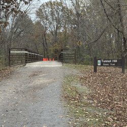
    An excellent rail trail connecting 45 miles of truly rural spaces, this made for a great 2-day…read morebikepacking excursion. We cycled from Harrisburg to Karnak, stayed the night in a campground right at the end of the trail, and returned home the following day. If you were to start this exact trail from any population center, it would be teeming with visitors. But that's not the reality here. We didn't see more than two dozen other cyclists total in 2 weekend days in May -- we damn near had the place to ourselves. And we were the only campers at the campground on a Saturday night (although some people might have stayed away because of rain in the forecast). The path itself is in really good shape for such an old trail. It's well-maintained and well-marked, and best of all, it's shade the whole way. You're almost always surrounded by trees. The terrain is surprisingly interesting, and for a number of miles you follow wetlands. I also particularly liked the bridges, which employ used railroad ties beautifully. And of course, there is the namesake tunnel, which you hit around mile 22. If there is a downside, it's the relative lack of amenities. You're not going to have ample choices for groceries or restaurants. But at least water stations and dry good shops are still around every several miles. And you're not here for the restaurants anyway.

    Photos
    Tunnel Hill State Trail - Bridge

    Bridge

    Tunnel Hill State Trail - Turtle

    Turtle

    Tunnel Hill State Trail

    See all

    Salt Lick Trail

    Salt Lick Trail

    4.9(15 reviews)
    43.4 mi

    One of the coolest nature experiences in the St. Louis area (Metro/Illinois side) lies in Valmeyer…read more The trail is about a mile long but plan to walk at least two miles. Starting at the parking lot, I highly recommend the Salt Lick Trail, which ascends to a hill (lots of steepness!). As you walk further on the trail, you get rewarding views. Near the end of it, you'll get a great view in which, on a clear day, you can see the St. Louis skyline. There are two other trails that link to the Salt Lick Trail. One of them starts at some church in Valmeyer.

    This is a moderately challenging trail with lookout points and views in otherwise relatively flat…read morefarming country. The trail is well-marked once you get on the trail. The most challenging and interesting route is to hike up Salt Lick Trail, take a brief left on Newman Trail, and return to your car via the Johnson Trail. The loop is a lot simpler than it sounds (see my Garmin map pic). This resulted in a 3-mile loop with 551 feet of elevation gain, up to a max elevation of 858 ft near the outlook. There are occasional viewpoints with benches all of the way up, with a flat limestone outlook at the point. There are steep areas (and steps with a cable). I would argue that the woods and limestone bluff are more interesting than the surrounding farmland. On your return via the Johnson trail, look up and left at the bluffs to see caves emerging from the historic salt mine. If you take this route, the abandoned salt mine building will be at the end of the Johnson trail, near the parking lot return. It was moderately advanced, and I recommend good hiking boots. Enjoy!

    Photos
    Salt Lick Trail
    Salt Lick Trail
    Salt Lick Trail

    See all

    Homer F Stemler Memorial Walking Trail - Sign at entrance

    Homer F Stemler Memorial Walking Trail

    4.3(6 reviews)
    48.6 mi

    This is a great and convenient trail for all ages! Our group ranged from young children to…read moreretirees. The parking is limited, but we were easily able to park on the side of the road. Overall, it took our group about an hour, but we stopped to talk and take in the scenery. We saw a family using a jogging stroller. However, if you're debating using a stroller vs pack, it would probably be easier to wear younger children in a hiking pack.

    It wasn't until about a month ago, I first heard about this place. I've developed a new interest in…read morehiking and this seemed to be the perfect place. It is somewhat a "hidden gem" and it's not marked on the roads so you gotta use your GPS to get you there. There is a small parking lot (for about 3-4 cars) where the trail starts. From the lot you will be greeted with plenty of signage, including the warnings and history of Homer Stemler. Be sure to take a picture of the map, which is near the trailhead. Pros: the trail, for the most part was moderately flat, with a few hills here and there. Very peaceful, and not many people were on the trails. Not really muddy, except near the start. Some signage throughout the trail. There are three (with different lengths) to choose from. Cons: Trails are poorly marked, as one could easily get lost. (Then again, getting lost is fun, right? lol) Scenery gets old, as you're basically in the woods. Don't expect anything fancy, like an overlook. But you'll find a pond! Also, Internet was sketchy on my phone so if you use Alltrails, you're gonna need it. Be sure to bring bug spray, hat, and try to wear pants instead of shorts no matter how hot it is.

    Photos
    Homer F Stemler Memorial Walking Trail - Map

    Map

    Homer F Stemler Memorial Walking Trail - Map

    Map

    Homer F Stemler Memorial Walking Trail - Pamphlet

    See all

    Pamphlet

    Piney Creek Ravine Nature Preserve - hiking - Updated August 2026

    Loading...
    Loading...
    Loading...