Cancel

    Open app

    Search

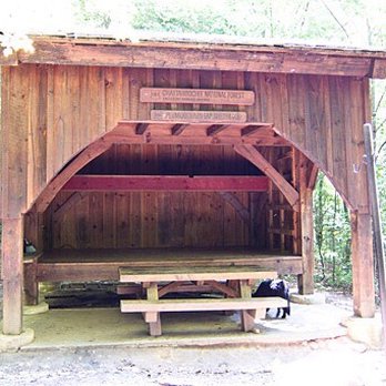
    Plumorchard Gap Shelter

    5.0 (1 review)

    Plumorchard Gap Shelter Photos
    Recommended Reviews - Plumorchard Gap Shelter

    Your trust is our priority, so businesses can't pay to alter or remove their reviews. Learn more about reviews.
    Yelp app icon
    Browse more easily on the app
    Review Feed Illustration

    7 years ago

    Helpful 4
    Thanks 0
    Love this 2
    Oh no 0

    Verify this business for free

    People searched for Hiking 539 times last month within 15 miles of this business.

    Verify this business

    Upper Moccasin Creek Falls

    Upper Moccasin Creek Falls

    5.0(2 reviews)
    6.2 mi

    Upper Moccasin Creek Falls is a true hidden treasure. If waterfalls were rated on attractiveness,…read morethis one would be a 10!!! ~~~ THE EXPERIENCE You start out on the Hemlock Falls Trail. The trail follows Moccasin Creek closely for its entire length to the falls. The beauty of Moccasin Creek is that nearly all of it is fast flowing water, loaded with endless cascades and multiple waterfalls. You will see at least a dozen waterfalls before you even reach Upper Moccasin Creek Falls. This is due to the river dropping from 2800 feet elevation to 1868 feet elevation on its way to Lake Burton. That's over 932 feet in a 5 mile stretch. There are around 7 falls between 8-12 feet tall and many more that are only 5-8 feet tall, but gorgeous in their own right. My visit was after a 4 day period of rainfall that saturated everything north of Atlanta in Georgia, so the water volume was great. Also, this sort of saturation spawns several other waterfalls that would likely be dry in a less rainy seasons. We found THREE large ribbon-like waterfalls at least 35-50' in height just off the trail looking into the woods. They were not on Moccasin Creek itself, but acted as tributaries [a river or stream flowing into a larger river or body of water]. There is even a small 5 foot waterfall directly on the trail. ~~~ UPPER MOCCASIN CREEK FALLS On my first attempt I was defeated trying to make it to this 2nd waterfall, which is a gorgeous 40' drop upstream. I tried to follow the trail past Hemlock Falls, but did not realize you must cross through Moccasin Creek about 50 yards past the crest of the falls. Once on the other side of the creek you will pick up a faint trail that keeps you above the river most of the 3/4 of a mile journey. I CAN'T STRESS ENOUGH that you MUST CROSS through the creek above Hemlock Falls. On my first attempt a few weeks prior, I did not cross through the creek and went as far as I could before reaching an impenetrable rhododendron patch. To reach Upper Moccasin Creek Falls, the creek must be on your right side, not your left. * * * NOTE - The trail to Upper Moccasin Creek Falls is considerably more difficult than the first half of the trail to Hemlock Falls. The trail is not too hard to follow, but it can be hard to see at times if you aren't familiar with hiking. Also, it can be very dangerous in some areas because sheer drops of 30-50 feet are only one footstep away. You will have to climb over and around lots of downed trees. * * * WEAR SHOES WITH GRIP, otherwise don't bother with this trail on days after recent rainfall. Once you reach the falls, we found the easiest trail down to the base was closest to the top of the falls. I regret not using a small spur trail to visit the top of the falls while heading down to the base. Satellite images on Google Earth show what looks like another smaller waterfall or cascade just above Upper Moccasin Creek Falls. ~~~ [ THINGS TO KNOW ] Hiking Distance: 3.5 miles (roundtrip) Difficulty: Moderate (I do not recommend for children under 12 or elderly) Creek Crossings: YES (1 bridged & 1 directly though Moccasin Creek) Elevation Gain: 752 feet Waterfall Height: Approx 40 feet Access to top of falls: YES Access to base of falls: YES Pool of water @ base of Falls: YES Sitting areas @ base: YES RESTROOMS: NO PARKING: YES (12+ cars) ~~~ FINAL THOUGHTS Upper Moccasin Creek Falls is one of the most attractive waterfalls I've seen on one of the most attractive rivers in the state. It is full of cascades and secondary waterfalls to delight the ears and dazzle the eyes. But it is not for the casual walker, it requires a little skill and spirit of adventure. It is not terribly difficult, but it also is not for the faint of heart. ENJOY! 2020 / 17

    If I knew that Upper Moccasin Creek Falls was as pretty as it ended up being, I would have visited…read moreit sooner when I paid Hemlock Falls Trail a visit a couple years back! So lets start there. To even reach Upper Moccasin Creek falls, you first need to get yourself to Hemlock falls Trail, which is right across the street from Moccasin Creek State park. Drive on into the Hemlock falls trail, which turns into dirt/gravel road. There'll be a trail parking lot and a noticeable trail that ultimately takes you to Hemlock Falls, which is about a mile to Hemlock falls. If you make it to Hemlock falls, which is a fine waterfall, that's just fine! However, if you want to see a much bigger, larger and "whoa" worthy falls, take the trail to just to the right of the opening that leads you to Hemlock. First things first, and this is a cautionary tale from Richard R. If you want to get to Upper Moccasin Creek falls, you have to cross the flowing water above Hemlock falls so that the creek is on your right. Yep, the water feeding hemlock is what you need to cross. When we did cross it it ended up being for us, just about knee deep (I'm 6'1"). Once you cross over, the trail to Upper Moccasin Creek is easily able to follow, but while easy to follow, understand it's also much more challenging than the trail to Hemlock. While more challenging, it's not overbearing or impossible to do. It is slippery, muddy at times, which sucks because the trail sometimes narrows to some pretty large drops you don't want to be a victim of. Heading to the actual falls requires you going down a steep decline to a large set of rocks that rest right in front of the falls. Stand on this (CAREFULLY) and bask at the glory. The actual waterfall is roughly 40 feet, and it crashes powerfully into a pool just at the bottom of the falls. Can you swim in the pool? I don't see why not but I didn't. You can't take bad photos here and while it was tiresome to get here, I think it was worth it. This is coming from a guy who does NOT like getting wet on hikes. Just over 3 miles is the round trip of this hike, and again while the trail to hemlock is not so bad, Upper Moccasin is a bit more of a challenge. I don't recommend tackling this by yourself. Long story short, the falls here were beautiful, which includes Hemlock falls. If you're in this area and you want to see a really beautiful fall that requires some work to get to it, do yourself a favor and check it out!

    Photos
    Upper Moccasin Creek Falls - Lots of downed trees to navigate around/through

    Lots of downed trees to navigate around/through

    Upper Moccasin Creek Falls
    Upper Moccasin Creek Falls - One of many sheer drops directly next to the trail. Easily a 50-60 foot tumble sure to injure or worse.

    See all

    One of many sheer drops directly next to the trail. Easily a 50-60 foot tumble sure to injure or worse.

    Riley Moore Falls

    Riley Moore Falls

    5.0(4 reviews)
    27.3 mi

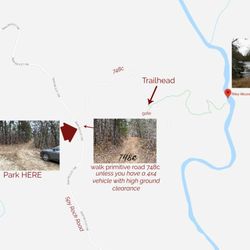
    I just wanted to update my 3/15/20 review below to add I've now done this hike several times, but…read moreTHIS time I had the chance to hike it with a friend who is directly related to the namesake of the waterfall... Riley Moore. Sandie is a church friend of mine and Riley Moore was her Great Great Uncle (I believe that's right). He once upon a time operated a grist mill here at the top of the falls. She's been trying to get here to see the waterfall, but couldn't find it and wanted to join us (along with her family) since I knew the way. Upon further research I discovered there are actually still remnants of the mill including visible drill holes, spikes and bolts. Thought that was pretty cool info to share! [ [ [ PREVIOUS REVIEW ] ] ] Riley Moore Falls is small in height but HUGE in personality. It's located off State Road S37-748, which is a nicely maintained gravel road where cars and trucks alike can comfortably traverse. ~~~ DIRECTIONS From Westminster, SC - DO NOT turn onto Cobb Bridge Road from Long Creek Hwy (Hwy 76) where you will see the brown & white sign pointing you in the direction of Riley Moore Falls. Our GPS had us go this way, then left onto State Road S37-748, but the road was CLOSED during our visit! INSTEAD, turn onto PU-32 also known as Rocky Fork Road. Turn left onto a gravel road near Rocky Fork Baptist Church and follow that until it dead ends @ State Road S37-748 (also known as Spy Rock Road). Turn right and drive approx. 1.4 miles (4 minutes) to 748c (aka Riley Moore Shoals Road). Park at the intersection of State Road S37-748 and 748c. DO NOT ATTEMPT TO DRIVE 748c in a car or minivan. Low clearance vehicles will find the terrain on this road to be VERY difficult to navigate without bottoming out or getting stuck. I'd also recommend 4x4 capability on wet days! There can be several deep-pocketed muddy areas after heavy rains. ~~~ THE TRAIL Once you reach the intersection of Spy Rock Rd (S37-748) and 748c, park roadside on Spy Rock, secure your vehicle and begin your hike approx. 1/2 mile down the "primitive road." IF you have a high ground clearance SUV or truck, you can drive the primitive road another half mile or so to a second parking area near the trailhead. The primitive road is VERY BUMPY  and can be muddy in spots after heavy rains, so a 4x4 is best. After reaching the second parking area, follow the marked trail on the left!!! The trail is a little over a 1/2 mile to the falls from here. The trail is fairly straightforward and easy to follow. ~~~ THE FALLS Once you reach the Chauga River, you will notice a large sandy area with plenty of room for an entire horde of hikers!!! Riley Moore Falls is not very tall (only about 12 feet), but it is very wide and has a deep base pool. PRO TIP - Bring swimwear, towels and a picnic, but be sure to pack it in and pack it out. ~~~ THINGS TO KNOW Hiking Distance: 2 miles (round trip to falls from S37-748) Difficulty of hiking 748c: All downhill to trailhead (moderate return) Difficulty of hiking trail to falls: EASY Creek Crossings: NO Elevation Gain: 357 feet Waterfall Height: Approx 12 feet Access to top of falls: NO - not without getting wet Access to base of falls: YES Pool of water @ base of Falls: YES Sitting areas @ base: YES + sandy beach RESTROOMS: NO PARKING: YES (along road) + secondary parking area closer to trailhead for trucks and high ground clearance vehicles with room for about 6 cars. ~~~ [ FINAL THOUGHTS ] A lovely waterfall in any season, but also a great spot for a summer swim. While we had the waterfall practically to ourselves during our Mid-March expedition, be advised other trail website reviews say it gets trashy & crowded in summer months. What a shame if that is true because it truly is a treasure. ENJOY! 2022 / 74 #UPDATE 178

    This is the best waterfall we got to visit in SC this far. After we left Reedy Branch Falls we…read moredrove here. Well, as close as we could get. I didn't realize that we couldn't drive all the way to the trailhead so we had a long hike in store due to me having to carry my toddler most of the time. I should have re-read the previous reviews before coming. My friend did help me carry her as well and for that I was very thankful. So definitely don't recommend this hike with a little one unless strapped in a carrier. Also, I don't recommend it for the elderly either. It's definitely a wilderness hike deal with roots and elevation change. In fact, it's mostly downhill on the way to the falls, but on the way back it's pretty much all uphill, which was not fun with aforementioned young child. It's about a half mile to the actual trailhead and then another 0.7 mile to the falls. That's about 2.4 miles round trip. The reason of course that my boys absolutely became enamored with this place is the large swimming hole. It is wonderful and has plenty of space. The waterfall itself is beautiful and although it's not as tall as others, its width is quite impressive. I was trying to get as close as I could and even noticed a hidden part of the falls inside of the rock structure. That was so cool!! The sand at the base and shore give it a beachy vibe. We definitely packed it in and out making sure not to leave anything behind as to preserve the area as best as possible. Needless to say we were wiped by the time we made it back to our vehicles, but we're still glad we decided to venture here. Coming back with my hubby and boys in the very near future. Happy yelping!

    Photos
    Riley Moore Falls
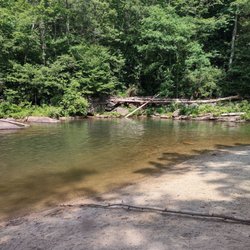
    Riley Moore Falls - CREATED FROM GOOGLE MAPS

    CREATED FROM GOOGLE MAPS

    Riley Moore Falls

    See all

    Martin Creek Falls - Base of Martin Creek Falls approximate height here is about 15 to 18 feet of the overall 30 feet height of the entire falls.

    Martin Creek Falls

    4.7(3 reviews)
    14.3 mi

    Beautiful waterfalls and very easy to get to from warwoman dell parking lot. The trail is abt 2…read moremiles one way with an easy water crossing within 5 min. You can avoid it if you take the trail on the right of road crossing instead of going straight. The path is mostly gentle and downhill to falls but it felt ssteep and uphill on our way back from pinnacle knob at the end of 8 Miles. Always an awesome hike especially after rain or with fall colors

    Martin Creek Falls is a beautiful secluded waterfall in Clayton, GA near Warwoman Dell. It is part…read moreof the Chattahoochee National Forest that encompasses the entire Northeast corner of the state of Georgia. The forest itself is 750,145 acres and is so large that it is divided into regions. Martin Creek is located in the Chattooga River District and specifically in Rabun County, whom incorporates the largest portion of the National Forest. 148,684 acres of this massive forest system lie within Rabun County borders. Depending on how much you like hiking, you can get to Martin Creek Falls on a short 1/2 mile hike via Finney Creek Road or a longer 2 mile hike (one way) from Warwoman Dell via the Bartram Trail. If you choose to hike from Warwoman Dell, your extra effort will be rewarded with two additional waterfalls as well as a loop trail highlighting the history of the area. Becky Branch Falls is located near the trailhead at Warwoman Dell and an additional unnamed waterfall is about 1/4 mile south of Martin Creek Falls. Only about 8 feet tall, but it's multiple levels make it a beauty. Martin Creek Falls is one of the prettier waterfalls in North Georgia. It is a multi-tiered waterfall that looks as if it goes on forever from the base. It is also one of the few waterfalls that I wish the vegetation would be cut away to make the full view of the falls visible. From the deck at its base you can see the largest drop, but the upper tiers become more difficult to see as vegetation near the middle tier blocks the view. Still, it is a gorgeous waterfall that makes wandering in this neck of the woods an incredibly satisfying adventure. The lower part of the falls are shaded while the upper part is sunny, so bring a UV filter (which I forgot) for best DSLR results. DIRECTIONS From US-23 (Hwy 441) in Clayton, Georgia travel east on Rickman Road. In 1/2 a mile it will merge into Warwoman Road. 2.5 miles from here you will pass the parking entrance to Warwoman Dell, which is difficult to see, but look for a small brown sign with a picnic table symbol and turn right. You can either park here and take Bartram Trail to the falls (about 2 miles one way) OR continue along Warwoman Road to Finney Creek Road. Approximate address for Finney Creek Road is 3742 Warwoman Rd, Clayton, GA 30525. TURN LEFT. It is a gravel road across from an open grassy field. The trailhead to the falls is approximately 1.1 miles from Warwoman Road or approximately 1/2 mile from the Wildlife Management Check-In station that you will pass along Finney Creek Road. Hike from this trailhead to the falls is approximately 1/2 mile round trip. Recommended for families with young children as they can also splash around in the pool of water at the waterfalls base, so bring their swimsuits and ENJOY! 2018/54

    Photos
    Martin Creek Falls - The bridge to the viewing deck

    The bridge to the viewing deck

    Martin Creek Falls - The viewing deck

    The viewing deck

    Martin Creek Falls - The cascading stream heading downhill.

    See all

    The cascading stream heading downhill.

    Plumorchard Gap Shelter - hiking - Updated July 2026

    Loading...
    Loading...
    Loading...