Quartz Peak Photos


You might also consider


More like Quartz Peak
Recommended Reviews - Quartz Peak
Start your review...



A difficult hike with amazing views! I loved this hike. It's a long way back to the trailhead from the road and there are places where having 4x4 or higher clearance would be nice, but I saw a Prius at the trailhead. There are workarounds. It's a long and steady climb, definitely one of the more challenging hikes in the west valley. The last little bit there's some scrambling to get to the peak. The views are amazing and the giant slabs of quartz are beautiful. read more
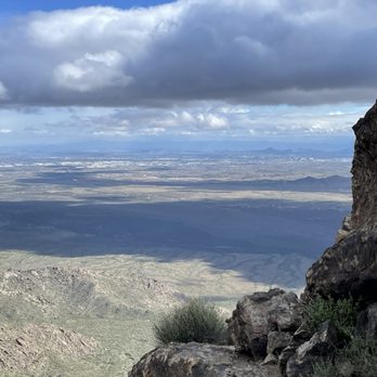


For years, I had stared out at the Sierra Estrella mountains wondering if I'd ever get the chance to hike to the top of Quartz Peak. I'm a Civic owner, so as soon as I heard about the sand roads and necessity of a high clearance/4x4 vehicle, I thought the day would never come (there's no way I'm buying a gas guzzling Jeep with a 30-mi each way work commute lol). That is, until I met some other awesome hikers from the Valley and coordinated an epic carpool! We met up in downtown Phoenix and headed out in the Jeeps to Goodyear. After getting off the 10 and heading down Estrella/Rainbow Ranch roads for what seemed like a good while, along came the sand/dirt roads. And man did they live up to their reputation! Some super fun off-roading action ensued, and let's just say I was so glad I wasn't in my own little car. One of the hiking buddies advised that he once tried to get to the trailhead in his Dodge Caravan but got stuck in the sand and wrecked the transmission. Yikes! Once we got to the trailhead (obviously an adventure in and of itself), it was a steady 5-6 mile uphill climb to the summit. There are definitely some false Peaks to conquer along the way that are grueling physically and mentally; however, once you get to the last half mile or so, it's a fairly short scramble and totally doable. Once you get to the top, you are greeted by a fantastic view of West Valley, South Mountain, Four Peaks, the Supes, East Valley, and the vast desert to the southwest. The way down is easier on the cardio but harder on the knees due to loose rocks so watch your step and don't rush it. Your legs will probably be sore for the next day or two but it'll be accompanied by the feeling of accomplishment! I also recommend going with a group as I did. Strength and support in numbers people! Plus, you may meet someone new and make friends along the way! I'm not sure when I'll get the chance to hike Quartz Peak again, but now every time I look out to the west at it, the memories will never fade! read more




11 years ago
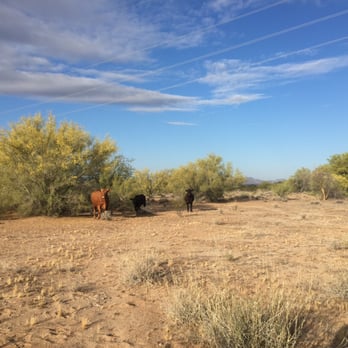
About an hour's drive from exiting the I-10, heading south on Estrella Parkway, your adventure begins on the road. The scenery transitions from a beautiful golf course community to farm lands then to remote desert. Around the intersection of Bullard Avenue and Riggs Road, an unmarked dirt road (around 6 miles) begins paralleling phone lines towards the mountain range. If you drive some little car or pseudo SUV with only 2wd, you might get stuck in the sand. Most of it is shallow but there are some deep sand areas where lower vehicles could get trapped. You're better off heading towards the trail in a 4wd high clearance vehicle. You'll eventually hit a "T" intersection. Veer right and you'll see a tiny vertical pole sign that says "Trail." Then go for another 2 miles and turn left at the second tiny replica sign that says "Trail." You eventually reach the dirt parking area. There is a single outhouse with no running water in case all that jiggling on the off-road part got to you! The hiking trail itself ascends the entire way and seldom has flat areas. Believe it or not, going up is easier technically because it's more a pain in the butt heading down since there's so much loose gravel and rock shards. But don't get me wrong, your cardio will really have its fair share of hard work as you climb about 2,473 ft. The actual summit is around 4,000 ft but you start at around 1,500 ft in the valley. (Sorry - rough "guesstimates"). The entire trail was shiny because it was full of bits of quartz and other mirror like rocks. This trail hugs ridges all the way to the peak. The last quarter mile is where the real scrambling begins. The trail is not as obvious and you have to take your time "finding" the cairns to lead you the way to the top. Breathtaking views await at the top. We were so high that we spotted a few hawks flying under us. There were some cool black lizards along the hike but luckily no snake sightings as we were warned. We found a geocache treasure at the top and logged our climb in the journal inside. That was a fun surprise! Sitting on the quartz was unique because it felt so cold! We were lucky that it rained the day before because temperatures were in the 70s and made it cooler to hike since there was not a whole lot of shade cover on this hike. It's definitely worth trying at least once in your lifetime. I would recommend bringing along a friend since it's so isolated. We only saw one other couple hiking the entire time! This is a hike recommended for more experienced hikers and it definitely is weather dependent too. read more


I love this hike! White quartz peak makes it special. Great workout on a remote trail. Continuous gain to the top. This hike will take you longer than you think. I wouldn't come out here without a high clearance, 4 wheel drive vehicle. Lots of miles of rutted road with deep sand. Bathroom at the trailhead. 1 hour drive from civilization. No water out here, just exposed hot desert. Hike in Winter only. read more


17 years ago
More info about Quartz Peak
Rainbow Valley, AZ 85326
Directions
(623) 580-5500
Call Now
Hours
Outdoor Amenities

Quartz Peak - hiking - Updated September 2026
Best of Rainbow Valley
People found Quartz Peak by searching for…
Scenic View in Rainbow Valley, AZ
Hiking Trails in Rainbow Valley, AZ
Watch Sunset in Rainbow Valley, AZ
Things to Do in Rainbow Valley, AZ
Off Road Trails in Rainbow Valley, AZ
Beautiful Views in Rainbow Valley, AZ
Easy Hikes in Rainbow Valley, AZ
Lookout Points in Rainbow Valley, AZ
Walking Trails in Rainbow Valley, AZ
Running Trails in Rainbow Valley, AZ
Sunset View in Rainbow Valley, AZ
Secluded Spots in Rainbow Valley, AZ
Scenic Overlook in Rainbow Valley, AZ
Hiking Trails Kid Friendly in Rainbow Valley, AZ
Places to Take Pictures in Rainbow Valley, AZ
Must See in Rainbow Valley, AZ
Photo Spots in Rainbow Valley, AZ
Stairs Workout in Rainbow Valley, AZ
Hiking With Kids in Rainbow Valley, AZ
Things to Do on a Rainy Day in Rainbow Valley, AZ
River Swimming in Rainbow Valley, AZ


