Raymondskill Falls Photos


You might also consider
More like Raymondskill Falls
Recommended Reviews - Raymondskill Falls
Start your review...

Reviews With Photos

What a natural gem. Quiet, short and long trails that get you away mentally into a peaceful journey. There were not a lot of people, folks that were there were very respectful of their surroundings. Highly recommend for novice to expert trekkers. Beware of bears fyi. Parking available, as well as restrooms.

Located right around Milford PA, this place is a find. The falls themselves are excellent. Apart from Bushkill, one of the best I found. The other nice thing about this place is the hiking. We hiked for almost 4 miles, and we didn't even scratch the surface. There are three awesome lookouts where you can see all three states (PA, NY, and NJ). Funny thing....it was hunting season, so looking down from the outlooks, we could see all these orange hunters walking through the woods. Definitely coming back here to do more hiking.

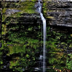
Raymondskill Falls is located within the Delaware Water Gap National Recreation area. Although this is a three-tier waterfall it is considered tallest waterfall in Pennsylvania. There are several trails you can take to view the falls. Only the one that leads to the bottom is dog friendly and you will need to walk off trail to actually see the falls. All the trails are very easy for anyone in mildly decent shape. Parking here is very limited. Definitely try to avoid peak times. These may be the tallest falls in PA but they are certainly far less impressive than other falls in the area.

When traveling from New Jersey to PA over the Dingman's Ferry Bridge make a right at the first light and the Raymondskill Falls is 4 miles up Route 209. Look for Raymondskill Road which will be on your left and follow the windy road up the mountain until you reach the trailhead entrance on your left to the falls. The falls has an elevation change of 178'. It is three-tiered with wooden viewing platforms. The descent to the upper tier is only 3/10ths of a mile but it steep with uneven ground. From the upper tier a trail will take you to the middle tier viewing platform. I thought the middle tier was the a gorgeous view. To view the bottom tier drive down the mountain and look for the Raymondskill Creek Trail. At the trailhead you will find a brick building with clean bathrooms. There is no fee to use the restrooms. The parking areas are small and during the peak of the season they fill up fast. Parking is not permitted on the side of the road and once you travel the Raymondskill Road, you will know why.

Minimal effort for a big payoff to enjoy the view of the three-tiered Raymondskill Falls! Well maintained trail (0.4 mile loop) with a lot of stone steps -- but railings in all of the steep parts made it easier. There were platforms at two of the levels for viewing and picture taking. Was able to see all 3 tiers in late July. You can park at either the Hackers trailhead parking lot (go straight onto trail; don't cross road) or the Raymondskill parking lot a bit further up the windy road. The only downside of our recent visit was that the 3 port-a-potties at the latter parking lot were very stinky.

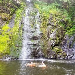
I came here with my friends for the sole purpose of doing a little morning hike near the Poconos. Little did we know, this is apparently the tallest waterfall in PA... We were pleasantly surprised by what awaited us (a 3 tier waterfall). PARKING/BATHROOM First we arrived to the parking area. It's quite spacious and not many people came to this waterfall, so theres enough space to park. We took our quick bathroom break there as well. (FYI, the toilet is just a hole and doesn't flush & there are caterpillar-like critters around.) With that part over with, we made our way to the actual trail. UPPER FALLS We followed the trail which lead us to the stairs up to the upper section of falls. It's small wide waterfall. Of course it's cool, but a lot awaits you as you go further down, so don't spend all your time there. MIDDLE FALLS Next, we went down to the middle tier of the falls. A lot more people congregate here to take pictures. Of course, it's a great view. But from experience, the highlight of this fall is the lower falls. I understand that many people won't and do not venture down the unmarked trails, but I do recommend it to those a bit more adventurous and looking for the best view. LOWER FALLS As I stated, the trail to the lower falls is not marked, but you can easily tell that a lot of people had gone down. It is wide and open enough to know that it's the trail downwards to the lower falls. At the very end of the trail, it gets quite narrow/slippery. You are literally walking down rocks. I found my hiking shoes to be very helpful, but even for me, I had to be very careful. Once I made it down, it was incredible! Seeing the waterfall up close was refreshing and honestly, the highlight of my day. Just be careful not to step too close to those wet rocks or you will fall in, but otherwise, it's so amazing here! And you get the best/unique pictures here, so it's all worth it.

A beautiful spot within the National Park Service - Delaware Water Gap Recreation Area. Approximately 3 miles South of Milford Borough, PA, the Raymondskill Falls are too good to miss. Both trailheads (lower and upper) are unpaved and limited for parking at peak times. The lower trail leads to the bottom of the falls, while the upper will take you to a perch at the top of the falls. While both trails are generally inclined downward getting to the falls, it's all uphill on the way back. There is a restroom at the upper parking area with signage and maps about the area.

So this is the home of the tallest waterfall in PA. So tall in fact that supposedly it's only a few feet shorter than Niagara Falls. OK, now before you think WTF, which is what I thought when I read that on the NPS website, know that there is a bit of a catch here. The catch of course is that while Niagara's height is measured as one continuous amount, Raymondskill Falls are just that, three individual falls which for whatever reason the NPS considers/measure as one. Don't let that little bit of magic math dissuade you from coming here because it is still a beautiful area and there are many more opportunities for exploring other waterfalls and endless amounts of hiking. The main parking lot (Hackers Trailhead) is on the small side but it does have a map of a few of the trails plus some restrooms and if you go down Raymondskill Road a little bit there is a smaller lot which is a great place to get parked in especially if you come here on a weekend. If you are looking for more hiking opportunities in the immediate vicinity of Raymondskill Falls, the National Park Service maintains several miles of trails nearby, which can be found on their website. www.nps.gov/dewa/planyourvisit/upload/mapCLIFFPARK.pdf We've done the Cliff Trail, Logger Path, Hackers Trail, Tri State Overlook and Minisink Overlook. While the trails are overall well maintained by the NPS there are parts of some especially near the falls that are slippery when wet (no, there is no Bon Jovi trail) or that have some steep elevation so handle with care. Like Cathy C. said, come on a weekday if possible, laying off especially holiday weekends in summer as the crowds get overwhelming, but the falls, trails and area are amazing and are well worth the short trip off of 209 if you're in the area.


This spot seems to be one of the few accessible during the winter months. After failing to enter multiple parks on a quest to hike in February, the hubby and I eventually stumbled upon this serene gem during our mini-moon and used it as a backdrop to take photos with our new DSLR camera. The hike to the waterfall was very short and rocky but that was to be expected. It was a great introduction to the Pocono Park region.

This is definitely my favorite local falls. There are a few different paths you can take that take you to different parts. If you go far left you'll be at the bottom where there's a small river. To the right you will end up at the top of the waterfall from the upper parking lot or if you go right from the lower parking lot you'll get right to the base of the waterfall. The hike isn't too bad going down but it can be tiring going up if you aren't in good shape. It's not a long hike at all though. The falls are gorgeous and within the last few years they redid the standing areas at the top and base of the falls which looks really nice. On the weekends it's pretty crowded and it can be hard to find parking but if you go on a weekday you're more likely to get an easy parking spot. Also, if you come while it's sunny there's a good chance you'll find a rainbow at the bottom of the falls which is pretty cool!

Amazing waterfalls. 1) This waterfalls is giant. 2) The park is completely free! 3) There is enough parking. 4) The falls has three section: Lower, Middle (which is the biggest section), and Upper (which is unmarked, but easily accessible). 5) Dingmans Falls Visitors Center (with Dingmans Falls and Silver Thread Falls), as well as George W. Childs Park (with 3 waterfalls) is also nearby.
Love these falls so much!!! Absolutely beautiful and FREE! The parking was easy and there is a bathroom. The trail to the view point was short and pretty easy! Ok for anyone who can handle stairs. There are also many unmarked side trails that take you to the Upper Falls and down to the creak. These are short but very steep . My kids needed to climb up using their hands .. but very fun!!

I have been coming here for years and it has always been so beautiful. I love morning hikes. Seeing the water falls and hiking through the trails is so picturesque. It's a great cardio workout. We climb up trail stairs and down. We go up some hills and down. It really depends on the direction you decide to take. Fall is my favorite time of year to come here when the weather is a bit cooler and there is not as much people around. The trails in this this park is very clearly marked and you can see trails that were created by the parks department plus some that were created by people who wanted to adventure off the regular trails. There are some very very small caves if you look around hard enough. I see them take a quick peek and I am on my way. I am not that adventurous, lol. This is definitely a fantastic place to visit if you are in the area. Just a couple of things to remember. Bug spray is your friend. Spray yourself, ticks are not fun and also be careful when running your hands on the wooden handrails because there may be splinters. I now take tweezers with me just in case splinters or ticks but this park is still a fantastic place to visit. read more


1 year ago
Really beautiful site, but it was hard to find. The address in the tour book took us to a closed, private road, and it's a windy two lane road with no shoulder, so it was also hard to find a place to turn around. There is a bit of a pull off area, and there is a restroom, but when I went off season (warm but not declared in season) it was locked. So mileage may vary on its usefulness. Luckily, if your eagle eyes spot the pullover parking lot, the falls are a pretty short walk. I recommend taking the path to the right to the top of the falls so you can then move down the steep incline instead of going up. The view from the bottom is very pretty. It's a good view and only needs like 20 minutes tops of your time. It was quite doable for my senior mother, but some parts were very slow moving. She enjoyed it, so it does still work for beginners as long as it's not been raining. Would recommend stopping by if you like seeing waterfalls. It's the tallest in the state and very scenic. read more

1 year ago
After a week of downpours we headed up to the Poconos to chase some waterfalls. Raymondskill was full of fury exploding over the weir like it had somewhere to be. The mist expanded well over the entire overlook of the middle falls where it swirled and danced almost to the top falls overlook. We parked in the bottom lot and took a light hike to the middle falls overlook - there were steps to the top overlook but my arthritic knee would not allow it so we drove up to the top parking lot and took another easy "hike" to the crest and I am glad we did. Photos don't do justice to the majesty of this natural wonder. The trails are friendly even to the weary and wobbly like me! Easily traversable but could be slippery in bad weather. The complete hike is only about a mile but you can still get a great view at the middle falls platform at roughly 1/2 mile in and out. Majestic & magical Raymonskill is glorious, but after the rain is a thunderous wonder and truly something to behold read more


What a natural gem. Quiet, short and long trails that get you away mentally into a peaceful journey. There were not a lot of people, folks that were there were very respectful of their surroundings. Highly recommend for novice to expert trekkers. Beware of bears fyi. Parking available, as well as restrooms. read more


Located right around Milford PA, this place is a find. The falls themselves are excellent. Apart from Bushkill, one of the best I found. The other nice thing about this place is the hiking. We hiked for almost 4 miles, and we didn't even scratch the surface. There are three awesome lookouts where you can see all three states (PA, NY, and NJ). Funny thing....it was hunting season, so looking down from the outlooks, we could see all these orange hunters walking through the woods. Definitely coming back here to do more hiking. read more


7 years ago
Raymondskill Falls is located within the Delaware Water Gap National Recreation area. Although this is a three-tier waterfall it is considered tallest waterfall in Pennsylvania. There are several trails you can take to view the falls. Only the one that leads to the bottom is dog friendly and you will need to walk off trail to actually see the falls. All the trails are very easy for anyone in mildly decent shape. Parking here is very limited. Definitely try to avoid peak times. These may be the tallest falls in PA but they are certainly far less impressive than other falls in the area. read more


5 years ago
When traveling from New Jersey to PA over the Dingman's Ferry Bridge make a right at the first light and the Raymondskill Falls is 4 miles up Route 209. Look for Raymondskill Road which will be on your left and follow the windy road up the mountain until you reach the trailhead entrance on your left to the falls. The falls has an elevation change of 178'. It is three-tiered with wooden viewing platforms. The descent to the upper tier is only 3/10ths of a mile but it steep with uneven ground. From the upper tier a trail will take you to the middle tier viewing platform. I thought the middle tier was the a gorgeous view. To view the bottom tier drive down the mountain and look for the Raymondskill Creek Trail. At the trailhead you will find a brick building with clean bathrooms. There is no fee to use the restrooms. The parking areas are small and during the peak of the season they fill up fast. Parking is not permitted on the side of the road and once you travel the Raymondskill Road, you will know why. read more


Minimal effort for a big payoff to enjoy the view of the three-tiered Raymondskill Falls! Well maintained trail (0.4 mile loop) with a lot of stone steps -- but railings in all of the steep parts made it easier. There were platforms at two of the levels for viewing and picture taking. Was able to see all 3 tiers in late July. You can park at either the Hackers trailhead parking lot (go straight onto trail; don't cross road) or the Raymondskill parking lot a bit further up the windy road. The only downside of our recent visit was that the 3 port-a-potties at the latter parking lot were very stinky. read more


I came here with my friends for the sole purpose of doing a little morning hike near the Poconos. Little did we know, this is apparently the tallest waterfall in PA... We were pleasantly surprised by what awaited us (a 3 tier waterfall). PARKING/BATHROOM First we arrived to the parking area. It's quite spacious and not many people came to this waterfall, so theres enough space to park. We took our quick bathroom break there as well. (FYI, the toilet is just a hole and doesn't flush & there are caterpillar-like critters around.) With that part over with, we made our way to the actual trail. UPPER FALLS We followed the trail which lead us to the stairs up to the upper section of falls. It's small wide waterfall. Of course it's cool, but a lot awaits you as you go further down, so don't spend all your time there. MIDDLE FALLS Next, we went down to the middle tier of the falls. A lot more people congregate here to take pictures. Of course, it's a great view. But from experience, the highlight of this fall is the lower falls. I understand that many people won't and do not venture down the unmarked trails, but I do recommend it to those a bit more adventurous and looking for the best view. LOWER FALLS As I stated, the trail to the lower falls is not marked, but you can easily tell that a lot of people had gone down. It is wide and open enough to know that it's the trail downwards to the lower falls. At the very end of the trail, it gets quite narrow/slippery. You are literally walking down rocks. I found my hiking shoes to be very helpful, but even for me, I had to be very careful. Once I made it down, it was incredible! Seeing the waterfall up close was refreshing and honestly, the highlight of my day. Just be careful not to step too close to those wet rocks or you will fall in, but otherwise, it's so amazing here! And you get the best/unique pictures here, so it's all worth it. read more


6 years ago
A beautiful spot within the National Park Service - Delaware Water Gap Recreation Area. Approximately 3 miles South of Milford Borough, PA, the Raymondskill Falls are too good to miss. Both trailheads (lower and upper) are unpaved and limited for parking at peak times. The lower trail leads to the bottom of the falls, while the upper will take you to a perch at the top of the falls. While both trails are generally inclined downward getting to the falls, it's all uphill on the way back. There is a restroom at the upper parking area with signage and maps about the area. read more


9 years ago
So this is the home of the tallest waterfall in PA. So tall in fact that supposedly it's only a few feet shorter than Niagara Falls. OK, now before you think WTF, which is what I thought when I read that on the NPS website, know that there is a bit of a catch here. The catch of course is that while Niagara's height is measured as one continuous amount, Raymondskill Falls are just that, three individual falls which for whatever reason the NPS considers/measure as one. Don't let that little bit of magic math dissuade you from coming here because it is still a beautiful area and there are many more opportunities for exploring other waterfalls and endless amounts of hiking. The main parking lot (Hackers Trailhead) is on the small side but it does have a map of a few of the trails plus some restrooms and if you go down Raymondskill Road a little bit there is a smaller lot which is a great place to get parked in especially if you come here on a weekend. If you are looking for more hiking opportunities in the immediate vicinity of Raymondskill Falls, the National Park Service maintains several miles of trails nearby, which can be found on their website. www.nps.gov/dewa/planyourvisit/upload/mapCLIFFPARK.pdf We've done the Cliff Trail, Logger Path, Hackers Trail, Tri State Overlook and Minisink Overlook. While the trails are overall well maintained by the NPS there are parts of some especially near the falls that are slippery when wet (no, there is no Bon Jovi trail) or that have some steep elevation so handle with care. Like Cathy C. said, come on a weekday if possible, laying off especially holiday weekends in summer as the crowds get overwhelming, but the falls, trails and area are amazing and are well worth the short trip off of 209 if you're in the area. read more


7 years ago


8 years ago
This spot seems to be one of the few accessible during the winter months. After failing to enter multiple parks on a quest to hike in February, the hubby and I eventually stumbled upon this serene gem during our mini-moon and used it as a backdrop to take photos with our new DSLR camera. The hike to the waterfall was very short and rocky but that was to be expected. It was a great introduction to the Pocono Park region. read more


4 years ago
7 years ago
This is definitely my favorite local falls. There are a few different paths you can take that take you to different parts. If you go far left you'll be at the bottom where there's a small river. To the right you will end up at the top of the waterfall from the upper parking lot or if you go right from the lower parking lot you'll get right to the base of the waterfall. The hike isn't too bad going down but it can be tiring going up if you aren't in good shape. It's not a long hike at all though. The falls are gorgeous and within the last few years they redid the standing areas at the top and base of the falls which looks really nice. On the weekends it's pretty crowded and it can be hard to find parking but if you go on a weekday you're more likely to get an easy parking spot. Also, if you come while it's sunny there's a good chance you'll find a rainbow at the bottom of the falls which is pretty cool! read more


11 years ago
Amazing waterfalls. 1) This waterfalls is giant. 2) The park is completely free! 3) There is enough parking. 4) The falls has three section: Lower, Middle (which is the biggest section), and Upper (which is unmarked, but easily accessible). 5) Dingmans Falls Visitors Center (with Dingmans Falls and Silver Thread Falls), as well as George W. Childs Park (with 3 waterfalls) is also nearby. read more


8 years ago
Love these falls so much!!! Absolutely beautiful and FREE! The parking was easy and there is a bathroom. The trail to the view point was short and pretty easy! Ok for anyone who can handle stairs. There are also many unmarked side trails that take you to the Upper Falls and down to the creak. These are short but very steep . My kids needed to climb up using their hands .. but very fun!! read more

9 years ago
Raymondskill Falls are a hidden gem off Route 209 a few miles south of Milford PA. Definitely worth the stop, but be prepared for the fairly short but challenging hike from the parking lot to the view of the falls. Rest rooms are available and located near the main parking lot. The main lot is on the small side and can fill up on weekends during the summer months. There is another even smaller lot which joins up with an alternate path down to the falls. No restroom located there, though. I live locally, and suggest visiting on a weekday when the site is not as busy with tourists. The falls are simply breathtaking! read more


We were in town visiting friends in Stroudsburg last weekend and took advantage of the unseasonable warm weather to cross this falls off our bucket list. When we got to the "park" we initially drove past the main parking area up to just before the bridge and parked off to the side and hiked down the side of the mountain because I heard falls and were treated to a smaller upper falls that appeared to be relatively secluded and not heavily hiked judging from the lack of trails. After taking a few photos we ventured down to the main area and lucked out to score a parking spot as a car was just pulling out (sheer luck as this place was pretty packed on Saturday). The trails are clearly marked and each leads to a different vantage point. We went with the middle trail that led to the mid point in the falls and provided awesome photo ops. There is also an upper viewing area that has steps leading up to it and another trail that I'll assume leads to the very bottom of the falls but since hubby and I were battling a cold we just weren't up for the additional hiking but we will definitely be sure to check it out on our next visit. I would consider the middle trail easy to moderate due to having to trek back uphill but certainly easy enough for all skill levels. The trails are blocked with fencing to protect the natural area but I feel it takes away from the goal as it makes it feel institutional and cage like, not at all like you're hiking through an amazing wooded wonderland. It clearly states online that dogs are not allowed so we left our golden back in our hotel room but upon arriving we saw many people hiking with their pets so I guess it just depends on the season and if there are rangers watching. read more


11 years ago
7 years ago
7 years ago
7 years ago
8 years ago
This place is magical! I felt like Pocahontas sitting alongside the streams. Absolutely worth getting lost trying to find this place driving down the winding PA roads. Make sure you are wearing hiking boots or sneakers with grips! I wasn't wearing the proper shoes and slipped a couple times walking on the trails. Definitely a MUST SEE and a great workout! read more

8 years ago
Pennsylvania's highest waterfalls, Raymondskill Falls is my favorite spot to visit or take friends in any season. The park (NPS) has recently renovated the viewing platforms and the trails to both the middle and upper views are well maintained. I highly recommend making your way to the northern end of the Delaware Water Gap National Recreation Area to check out these falls. Afterward you can extend your visit with a hike along the Cliff Trail and/or Hackers Falls. read more


8 years ago
9 years ago
9 years ago
10 years ago
More info about Raymondskill Falls
917 Raymondskill Rd
Milford, PA 18337
Directions
(888) 745-3101
Call Now
Hours
Outdoor Amenities
Ask the Community - Raymondskill Falls
Review Highlights - Raymondskill Falls


Why does Yelp recommend reviews?
2 reviews that are not currently recommended
The reviews below are not factored into the business's overall star rating.
10 years ago
5 years ago
Raymondskill Falls - hiking - Updated July 2026
Best of Milford
People found Raymondskill Falls by searching for…
Trending Searches in Milford, PA
Blueberry Picking near Raymondskill Falls
Boat Tours near Raymondskill Falls
Cliff Jumping near Raymondskill Falls
Day Trips near Raymondskill Falls
Dog Friendly Beaches near Raymondskill Falls
Dog Friendly Trails near Raymondskill Falls
Jet Ski Rental near Raymondskill Falls
Kayak Rental near Raymondskill Falls
Kids Activities Indoor near Raymondskill Falls
Lakes & Ponds near Raymondskill Falls
Lookout Points near Raymondskill Falls
Off Road Trails near Raymondskill Falls
Outdoor Activities near Raymondskill Falls
Peach Picking near Raymondskill Falls
Picnic Spots near Raymondskill Falls
Public Shower near Raymondskill Falls
River Swimming near Raymondskill Falls
River Tubing near Raymondskill Falls
Rock Quarry near Raymondskill Falls
Scenic Night View near Raymondskill Falls
Scenic Overlook near Raymondskill Falls
Skyline View near Raymondskill Falls
Soccer Store near Raymondskill Falls
Splash Pad near Raymondskill Falls
Sunrise View near Raymondskill Falls
Swimming Holes near Raymondskill Falls
Swimming Lakes near Raymondskill Falls
U Pick Farms near Raymondskill Falls
Watch Sunset near Raymondskill Falls
Browse Nearby
Browse Brands
Related Searches in Milford, PA
Affordable Canoe Rental Options in Milford, Pennsylvania
Affordable Kayak Rental Services in Milford, Pennsylvania
Best Dog Hiking Trails Around Milford, Pennsylvania
Best Fishing Locations and Guides in Milford, Pennsylvania
Best Parks for Parties and Events in Milford, Pennsylvania
Best Places for Horseback Riding in Milford, Pennsylvania
Best Water Parks for Kids in Milford, Pennsylvania
Best Waterfalls and Swimming Holes in Milford, Pennsylvania
Check Out Great Playgrounds in Milford, Pennsylvania
Check Out Off Road Trails in Milford, Pennsylvania
Discover Baseball Fields Around Milford, Pennsylvania
Discover Dog Friendly Trails to Explore in Milford, Pennsylvania
Discover Fun Toddler Parks in Milford, Pennsylvania for Your Little One
Discover Kid Friendly Hiking Trails in Milford, Pennsylvania
Discover Popular Bike Trails in Milford, Pennsylvania
Discover Scenic Mountain Bike Trails Near Milford, Pennsylvania
Discover Soccer Fields in Milford, Pennsylvania Near You
Discover Top Nature Parks to Visit in Milford, Pennsylvania
Discover Top State Parks to Visit in Milford, Pennsylvania
Discover a Hiking Trail in Milford, Pennsylvania
Discover the Best Beaches in Milford, Pennsylvania
Discover the Best Night Hike Trails in Milford, Pennsylvania
Dog-Friendly Hikes With Dogs in Milford, Pennsylvania
Enjoy Camping Adventures Around Milford, Pennsylvania
Enjoy Exciting Mountain Biking Adventures in Milford, Pennsylvania
Enjoy Hiking Adventures in Milford, Pennsylvania
Enjoy Kayaking Adventures in Milford, Pennsylvania
Enjoy Off Leash Dog Hikes in Milford, Pennsylvania
Enjoy River Tubing Adventures in Milford, Pennsylvania
Enjoy Tent Camping Spots Around Milford, Pennsylvania
Enjoy Water Activities and Fun in Milford, Pennsylvania
Enjoy the Best Walking Trails in Milford, Pennsylvania
Explore Beautiful Parks and Green Spaces in Milford, Pennsylvania
Explore Easy Hikes Perfect for All in Milford, Pennsylvania
Explore Family-Friendly Zoos and Wildlife in Milford, Pennsylvania
Explore Free Picnic Areas Around Milford, Pennsylvania
Explore Fun Activities to Do in Milford, Pennsylvania
Explore Outdoor Basketball Courts for All Skill Levels in Milford, Pennsylvania
Explore Parks With Pull Up Bars in Milford, Pennsylvania
Explore Picnic Parks Near Milford, Pennsylvania
Explore Popular Campgrounds Near Milford, Pennsylvania
Explore Popular Picnic Areas Around Milford, Pennsylvania
Explore Popular RV Parks Around Milford, Pennsylvania
Explore Popular Scenic Overlook Points in Milford, Pennsylvania
Explore Scenic Lakes to Visit in Milford, Pennsylvania
Explore Top Dog Parks in Milford, Pennsylvania Near You
Explore Top Trampoline Parks in Milford, Pennsylvania
Explore Top Water Parks in Milford, Pennsylvania Today
Explore the Best Swimming Holes Around Milford, Pennsylvania