Cancel

    Open app

    Search

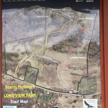
    Scenic Hudson's Long View Park

    4.0 (1 review)

    Scenic Hudson's Long View Park Photos

    You might also consider

    More like Scenic Hudson's Long View Park

    Recommended Reviews - Scenic Hudson's Long View Park

    Your trust is our priority, so businesses can't pay to alter or remove their reviews. Learn more about reviews.
    Yelp app icon
    Browse more easily on the app
    Review Feed Illustration

    8 years ago

    Helpful 1
    Thanks 0
    Love this 0
    Oh no 0

    Verify this business for free

    People searched for Hiking 639 times last month within 15 miles of this business.

    Verify this business

    Christman Sanctuary

    Christman Sanctuary

    4.9(8 reviews)
    27.5 mi

    The topography of this place is undulating but not too challenging, even for someone like me, a…read morecouch potato. A river runs through it. Along the way, there are some waterfalls of differing levels. Obviously, the volume of water is dependent on recent precipitation. The "mood" of the place depends of that flow. On most occasions, I could hear the rush of water before actually seeing it. It's an added bonus to this place, changing on a daily basis. Like a lot of things upstate, you've got to be informed about a place before you know it exists. If a co-worker hadn't told me about this sanctuary, I doubt I would have found it on my own. There is no fee but the parking lot is small; there's space for about eight vehicles. Check it out. It's a neat place. It'll do some good to get some fresh air.

    Note to self: September may not be the absolute best time to come here because of the very low…read moreflow. Still, there are plenty of things to like about this...once you find it. The falls seem to be commonly known as Bozenkill Falls but the road sign (pictured) says Christman Sanctuary, and the gravel parking lot isn't massive so it may be easy to miss. The first 100+ metres is mostly boardwalks so it's easy enough to navigate. Then comes rocky, uphill trail, but at least markers are readily visible and aplenty. On our first visit I feel like we barely scratched the surface, so will look forward to another visit. Thank you whoever you are, for helping to preserve and maintain this sanctuary!

    Photos
    Christman Sanctuary
    Christman Sanctuary - After a rainfall.

    After a rainfall.

    Christman Sanctuary - Lower falls - Christman Sanctuary

    See all

    Lower falls - Christman Sanctuary

    Kaaterskill Falls - March 2026

    Kaaterskill Falls

    4.6(168 reviews)
    21.2 mi

    The falls are truly incredible…read more The trail down to the bottom of the falls, is a bit tricky. But so incredibly worth it. I would suggest not to believe the sign saying 189 steps.... it is definitely more! Take drinking water because you'll need that for sure. We went back in August and the heat was definitely there. The parking lot was pretty packed but throughout the trails people were pretty evenly spaced out. Not so much at the base of the falls themselves but there was still plenty of room to move around freely.

    A very mild and easy hike with a beautiful payoff! Definitely bring your bathing suits because you…read morecan take a dip in the water--it's cool, refreshing, and perfect for cooling off after the walk. The waterfall and surrounding scenery are absolutely beautiful, and you can easily spend some time relaxing on the rocks and taking in the view. You don't have to get in the water if that's not your thing; there are plenty of rocks around the area where you can sit and enjoy the scenery. There are both upper and lower sections of the waterfall, so depending on how much walking you want to do, you can choose which area to explore. We walked to the lookout point first, which gives you a view of the waterfall from above. From up there, everyone below looks like little ants! Before reaching the bridge, there are stairs that lead down to the actual waterfall, which I definitely recommend checking out. Overall, it's a beautiful spot, and the hike is very manageable!

    Photos
    Kaaterskill Falls - View Of Stream

    View Of Stream

    Kaaterskill Falls
    Kaaterskill Falls

    See all

    Hannacroix Preserve

    Hannacroix Preserve

    4.0(1 review)
    14.8 mi

    The Hannacroix Ravine, a Nature Conservancy Preserve.  It is located in Clarksville, NY, off Cass…read moreRoad, and we had no problems finding the preserve using the directions on the Nature Conservancy website and Google Maps.  There are signs along the road and a small parking lot that holds two cars. I've heard it doesn't really get busy, so parking shouldn't be a concern, but just what I was told. (Note that the Hannacroix Ravine is different from the Hannacroix Preserve in New Baltimore, NY). We started off at the trailhead.  There isn't a kiosk at the beginning of the trail, so you might want to save a copy of the trail map to your phone beforehand. The trail meanders through woods, and is mostly flat or only a slight elevation change. My knees have been bothering me lately, so this was a great trail for me. The kids only complained moderately, so overall a success. There isn't a whole lot to do as far as exploring until you come to the creek. We had fun checking out the creek and wandering both up and downstream. We found some fish, newts, crayfish, and more. Being September, the stream was very low. Once we were done exploring the creek, we headed back the way we came. You can also do a loop, which puts you out to the road, and then you have to walk back a bit on the road. I don't think the road is too busy, but we figured the rest of the loop was similar to the first half, so we just went back how we had come in. I would say it was a couple miles from the trailhead to the creek. Overall, a pleasant hike with some nice exploring along the creek.

    Photos
    Hannacroix Preserve
    Hannacroix Preserve
    Hannacroix Preserve

    See all

    Lewis A. Swyer Preserve - Trail map

    Lewis A. Swyer Preserve

    3.5(2 reviews)
    1.2 mi

    I hate mud season. It's when the top 3 inches of soil thaws out but the ground stays frozen. It's…read moregreasy, slimy and can swallow your shoe whole. It makes any kind of outdoor activity treacherous. That's when I head to the Swyer Preserve and their boardwalk trail. Lewis Swyer Preserve is a 95 acre Nature Conservency site made up of a freshwater tidal swamp and a freshwater tidal marsh. The elevated boardwalk is a half mile trail from Rt. 9J to just before the railroad tracks that run along the Hudson. At the end of the trail is an observatory where you can see bald eagles and ospreys soaring. There's a ton of beaver activity with a beaver dam encroaching on the boardwalk. The boardwalk is a pretty easy stroll with one section in need of repair but on the whole a pretty awesome place while still keeping your feet dry. I only do this trail in spring and fall because in summer the poison ivy can be intense.

    Parking area is separated a short distance from the trailhead. There is a gravel path but still on…read morethe road shoulder, so take care. Well-maintained boardwalk with a few broken boards off to the side. There was a lot of poison ivy on the periphery of the trail, sometimes hanging over it. Mosquitoes were surprisingly not an issue, but there were plenty of bees. Wear long sleeves and long pants and watch your dog as they will brush against it. Beautiful views with wild irises, skunk cabbage, the creek, and flowering trees. The small observation tower gives good view of the whole area. Overall, I enjoyed it very much. My family did not. Some clearance of the periphery of the trail would be good.

    Photos
    Lewis A. Swyer Preserve - Train, nature, bridge, river

    Train, nature, bridge, river

    Lewis A. Swyer Preserve
    Lewis A. Swyer Preserve

    See all

    Overlook Mountain

    Overlook Mountain

    4.5(87 reviews)
    30.1 mi

    This place is absolutely amazing! I've hiked all the Catskills mountains three times over through…read morethe years and I had never been to overlook because there was no reason to but I had heard so much about this location I just had to visit and satisfy my curiosity on why this place is so popular. First off the parking lot is medium sized and parking on the road (even off the road) is risky because certain spots you are not allowed to park so arrive early, get a legit parking spot and save yourself the wasted trip or the hassle of returning to your vehicle to a ticket or it completely gone (towed). The hike up and back for Overlook is approximately 5 miles so everyone is spot on mentioning the distance. It's fairly steep all the way up and while you don't have any views on the way up, you do encounter some old ruins which is a neat break along the way. Once you do make it to the top you are met with a small shed that has some very minor historical information inside and on peak weekends you'll find stewards that can assist with information about the area and hiking tips. The fire tower can't be missed to the left after the small shed and the view is to the right of the shed. I have to say, I've been atop many mountains and it's been a long while since I've had my breath taken away but when I saw the view at Overlook it was breath taking. What made the view so beautiful and different than other mountains I've hiked is that the view is expansive with no mountains obstructing so you can see as far as the eyes can see. It's truly a remarkable view being so high up and seeing so far out. This mountain is known for its rattlesnake population. Sadly I never got to see one because I always hike in the early morning hours and they normally come out at around high noon when the sun is the hottest.

    Hiking is definitely a love-hate relationship! This mountain goes UP--and I mean all the way up…read more There are barely any flat or straight sections, so you're constantly climbing, weaving around corners, and then going back down just to do it all over again. I had to take frequent breaks to catch my breath because the climb was no joke. And honestly, the tower was probably the scariest part for me. The views from the top were absolutely beautiful, but I had to go up quickly and come back down just as fast because my fear was kicking in! Before tackling the mountain, we also walked a different trail, which was already exhausting. So by the time we started the climb, my legs were definitely feeling it. But once you finally reach the ruins and the tower, it all feels worth it. The scenery and views are honestly incredible, and it's such a beautiful place to see. Just be prepared: before you reach the top, you may question every life decision that brought you there!

    Photos
    Overlook Mountain
    Overlook Mountain
    Overlook Mountain

    See all

    Bash Bish Falls - Waterfall blocked by unnecessary protection.

    Bash Bish Falls

    4.3(72 reviews)
    26.5 mi

    It took me three attempts over three days to make it all the way to the waterfall, but it was so…read moreworth it! I took this journey at the start of February, and there was tons of snow on the ground. On the first day, I arrived at the Massachusetts parking lot around 3 PM I figured I had a good two hours before sundown. I turned back after walking a short way down the trail because it was so steep, I thought I was going to tumble into the river. When I got back, I watched a video of someone hiking on the Massachusetts side, and I realized that the trail is normally full of stairs This makes sense because it's very steep and that's why it's so short but because of the snow, the stairs are covered up I would definitely not recommend using the Massachusetts side in the winter On the second day, I got to the New York parking lot around 2 PM. I made it about halfway down the much more gradual and scenic trail before I turned back. I turned back because the sun disappeared behind the mountain, and it was dark and windy On the third day, I got to the New York side at 11 AM. This time I realized that the top of the trail is just always dark and windy because it's in a corridor between two mountain peaks. So I pressed on. It took me about one hour to get to the end of the trail. I walked pretty slowly and stopped to look at nature a lot. If you are not someone who is super confident staying on the path in the forest, these are fairly easy trails because it's just a straight line the whole way there and you are following the river the whole time. I'm so glad I didn't give up because the falls are one of the most beautiful magical things I've ever seen Instead of water flowing down through the ice, it was snow and slush bursting through the sections of the frozen waterfall the water exploding into 1 million tiny snowflakes from the top to the bottom I plan to come back here in the summer with my kids and I think they will really love it.

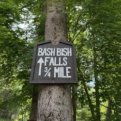
    Bash Bish Falls was just as beautiful as everyone says it is! The hike was worth every step, and…read moreseeing the waterfall in person was amazing. There's just something about being surrounded by nature that fills my cup. I LOVE to hike so this was my happy place. Even better, we got to share the experience with friends we've had for 24 years after meeting on a cruise. Good friends, beautiful scenery, and another memory made together. That's my kind of day. You can go I on the MA side which has lots of stairs but is a shorter walk or do the NY side with a short 3/4 mile hike to the falls.

    Photos
    Bash Bish Falls
    Bash Bish Falls - We came in on the NY side and hiked a bit

    We came in on the NY side and hiked a bit

    Bash Bish Falls

    See all

    Scenic Hudson's Long View Park - hiking - Updated September 2026

    Loading...
    Loading...
    Loading...