Cancel

    Open app

    Search

    Sewall Woods

    4.0 (1 review)

    Sewall Woods Photos

    You might also consider

    Recommended Reviews - Sewall Woods
    Your trust is our priority, so businesses can't pay to alter or remove their reviews. Learn more about reviews.
    Yelp app icon
    Browse more easily on the app
    Review Feed Illustration

    2 years ago

    Helpful 0
    Thanks 0
    Love this 0
    Oh no 0

    Verify this business for free

    People searched for Hiking 546 times last month within 15 miles of this business.

    Verify this business

    Russel C. Chase Bridge - Falls Path - Abandoned Excelsior Mill

    Russel C. Chase Bridge - Falls Path

    5.0(1 review)
    0.4 mi

    Very popular and well-travelled, the Bridge-Falls Path is a nice easy little trail, about half a…read moremile long. Starting downtown at the Wolfeboro Train Depot, it follows the path of the now defunct Wolfeboro Scenic Railway. The tracks are gone, but the scenic views remain. There's plenty of parking at the historic depot, and a short ride on your bike or a leisurely stroll will take you along Wolfeboro's Back Bay and past some informative signage telling the history of the area. After passing through the wooded shade and some interesting rock outcroppings, you will see the remains of Berry Mill, built in 1840, and still making excelsior when I was a kid in the early 80s. Here you can often find people fishing along the river, and others walking their dogs, taking photos, or just simply enjoying the sun. Crossing the bridge at Wolfeboro Falls, near the run-down water wheel, the Bridge-Falls Path comes to an end. But if you still have some adventure left in you, you can venture across the street and continue the 12 mile path onto the Cotton Valley Trail, also known as the Wolfeboro-Sanbornville Recreational Trail or the Honorable Russell Chase Memorial Path. The rails are still in place from here on, and still used once a year for hobbyists to try their own rail vehicles. But that's another review! The Bridge-Falls Path is lit for nighttime use, but I'm not really sure I'd go it alone in the dark. Unfortunate signs of graffiti are sparse (and oddly kooky- OctoCat, half-octopus half-cat! These vandals are likely young kids with an off-kilter sense of humor.) Overall, the Bridge-Falls Path is a great start to the Cotton Valley Trail.

    Photos
    Russel C. Chase Bridge - Falls Path - Back Bay section

    See all

    Back Bay section

    Castle In the Clouds

    Castle In the Clouds

    4.0(127 reviews)
    11.4 mi

    This destination was absolutely flawless - fantastic staff…read more- delicious food!! Room views are spectacular. New Hampshire life in these mountains are exquisite. Its AMAZING!!

    The place was amazing, very beautiful and views for days! The staff were very nice and informative…read more Now the not so good things: 1. It was very hot the day and you are forced immediately off the trolley to sit in a glassed in pouch that was 112 degrees for 20 minutes, which sets the tone of the experience in a negative way. You view the mansion hot and sweaty, which stinks (Pun intended). Even if it wasn't hot, people should have the option to skip the video. 2. The trolly is supposed to cycle every 15 minutes (trolly even said it on the way up). We waited over 30 minutes. 3. Some guests were chastised for things that could have been easily avoided by putting up signs. If you don't want people doing things which seem perfectly acceptable to do, put a sing up or put it at the end of your 20 minute video. I think the guests who were talked down too felt embarrased and it was unnecessary. 4. When you drive up to the attraction, there is parking, by the cafe. We parked, got out, and had to go up to some people working in the park to find that we had to continue driving up the mountain to get to the carriage house. Are signs that expensive? "Keep driving to see Castle In The Clouds" or "This way to see Castle in the Clouds".

    Photos
    Castle In the Clouds
    Castle In the Clouds
    Castle In the Clouds

    See all

    Bald Knob - View of Lake Winni from near the top!

    Bald Knob

    4.3(4 reviews)
    10.6 mi

    Steep. ?Private. Rocky. Good exercise. Great views of Lake Winnipesaukee. More to come . . .read more

    Also known as Bald Peak (and lending it's name to the nearby Bald Peak Colony Club) this little…read moremountain is a decent size to get in a half-day hike, depending on your ability, a picnic lunch, and some incredible views. It's a popular trek. There are also several hiking paths nearby which are maintained by the Castle Preservation Society, as well as Castle in the Clouds itself, and hiking trails at Mt. Shaw (I believe) nearby. I recommend sticking to the path along the eastern side (right-hand side as you approach the base) of the mountain. There are several very interesting places to explore just off the path, however they can get steep. The path travels up around the back of the rocky area. As you approach the outcropping, you will have an impressive view of Lake Winnipesaukee. When I was last there, there was a picnic table and camp fire as well. There are horse trails from the summit that travel west to Castle in the Clouds, but it's a long haul to get over there! (These trails are free and open to the public, but the Castle charges admission.) I believe I read that there are some geocaching spots up there as well. Parking is along the road right at the Tuftonboro/Moultonboro border by the town sign honoring local Olympians Hannah Hardaway and Wolfgang Moser.

    Photos
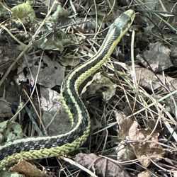
    Bald Knob - Cute little Eastern ribbon snake sunning itself.

    Cute little Eastern ribbon snake sunning itself.

    Bald Knob - Solomon's Plume

    Solomon's Plume

    Bald Knob - Sign at the trailhead.

    See all

    Sign at the trailhead.

    Jewell Falls

    Jewell Falls

    4.2(13 reviews)
    44.8 miNasons Corner

    This hike is a nice place to take a short stroll for the locals but not a place I would recommend…read moretourist to come. First off, it is only about half mile from parking to the waterfall. So total hike was only 1 mile. it is a WALK, not hike. Good for families with young ones. Be very aware that the mosquitoes here are super HUNGRY! I have never gotten so many bites within such a short time inside a hike! I got 6-7 bites all over my legs just from hiking here for 30 mins. My husband got 8+ bites all over his body! Luckily my little one only got 1 bite. We were all over Maine in the last 2 weeks including kayaking and out at Acadia national park. All outdoor activities and barely got any bites until now! There are other trails here too but after getting so many bites, we wanted to run away as fast as we could! I wish I didn't come here. View and waterfall are not worth it for trade off of these hungry hungry mosquitoes!! *sooo itchy* :-/ Bring bug spray if you wanna come!

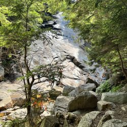
    Jewell falls is a waterfall of water flowing from the Fore River and is named for Tom Jewell who…read morewas one of the founders Portland Trails and very much alive today. Did you know that Portland Trails started in 1991? He donated the land around the falls and the rest of the land the trail walls through is a mix of public and private land. You see evidence of this with many marked signs that designate private property -- good to respect these so we can continue to walk these trails. Somehow I got lost off my usual path I take and ended up going on the greater fore river sanctuary trail loop around and across the railroad tracks, but the boardwalks were great! Back to the falls, if you start at the trailhead near Brighton ave, it's less than 0.25 miles of a walk. The falls are made of horsetails of rushing water over large slabs of rock. The trails are really well maintained and there's not too many people. You can definitely still hear traffic from some parts but there are a few quiet enclaves.

    Photos
    Jewell Falls
    Jewell Falls
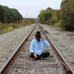
    Jewell Falls - My friend on the tracks at the entrance!

    See all

    My friend on the tracks at the entrance!

    Sewall Woods - hiking - Updated July 2026

    Loading...
    Loading...
    Loading...