Sierra Buttes Photos


You might also consider
More like Sierra Buttes
Recommended Reviews - Sierra Buttes
Start your review...

Reviews With Photos

This is a great place to do a little hiking, exploring and sightseeing from the top for a beautiful mountain. There is several way to get to the lookout, we rode in past the trail head up the gravel road, then to a trail that took us all the way past the upper parking lot, but then we hit too much snow in the middle of July. The hike to the top was only about 3/4 of a mile and a few stairs. Great views !!

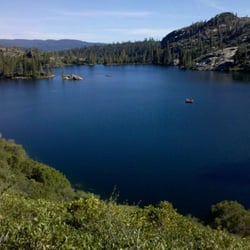
This is for Tamarack Lake not the actual Sierra Buttes. WWW.localhikes.com/hikes/tamarack lake 6922.asp! I'll see if I can get Yelp to make this lake its own place. We had a 4WD truck , ( I'm the hobbled one with Plantar Faciatis , so I got to ride, haha ) have to take it somewhat easy. The directions are on the above link. This is such an amazing area to hike, fish, camp and explore in. As you can see in the pictures the lake is absolutely breathtaking. And the good news is that there were zero mosquitoes. While the hiking distance is not far it is a bit steep and very rocky. You can get there hiking, 4WD or by horseback. It's an alpine lake and it's so worth the trip. It's remoteness is one of the great things about it. There are a couple of large rock fire rings and camping spots. We were there last week and were the only ones there. You can also hike in to the lake from the Tahoe Rim Trail. It's part of the Desolation Wilderness area. The mayflies were hatching and falling back into the water, not a very long lifespan. There were some fish, frogs and a small water snake ( its harmless ) that were feasting on the mayflies. There are a lot of other trails for day hikes out of this area that you should take advantage of if you are spending a few days. BTW there are plenty of Pine and Aspen trees but NO Tamarack's . kind of like Sardine Lake that has no sardines :)

Trails can be taken to the Lookout Building at the very top of the Sierra Buttes. Obviously it is uphill all the way (and steep in parts) but it can be conquered by taking a slow and easy approach up the western trail. Elevation: Highest point is ~8,800 ft. Difficulty: Moderate to Strenuous Hiking Season: June to October The trails up to the top of the Sierra Buttes offers wonderful views of various lakes on the way up . . . but spectacular 360 degree views are attainable from the balcony which completely encircles the Lookout Building at the top. The views from the lookout are the single highest point in the Lakes Basin area. However, beware that the steel stairs and walkways up the rock to the lookout can be a bit scary if you aren't fond of heights (or perhaps suffer from vertigo). Other Yelpers have posted photos of the steel stairs to give you a sense of what you're in for. Check out all the photos for a betters sense of the overall hiking experience.

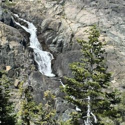
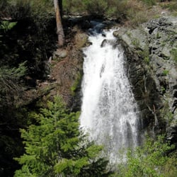
From pretty much anywhere near the Sierra Buttes, you can look up onto the huge crags and see the teeny tiny fire lookout perched precariously at the top. Actually getting to the fire lookout is not as difficult as you might think, and it is an incredibly rewarding hiking experience. There are several routes to get to the lookout, but we took the easiest way, which involved driving most of the way and hiking the last 2.5 miles. (The map I have provided here takes you to that trailhead.) The hike to the top is moderate--a few short, steep switchbacks but mostly steady, even climbing. The part of the hike that gives most people pause is at the very end--the 178 vertigo-inducing steps to the lookout itself. I was surprised to find that these were really more exhilarating than terrifying or exhausting. Views from the lookout are, as you would expect, spectacular. Unless you are a skilled winter mountaineer, I would recommend waiting until late-July to try this trail. We hit it in late June, and about 80% of the trail was snowbound, some of it dangerously so.

Sierra Buttes Fire Lookout was great! It's a 6 mile hike roundtrip. Climbing 1800 feet. 180 stairs at the end for the lookout. It's possibly one of the most beautiful sites I've even seen. I hiked it over labor day weekend and while it was busy it was not overwhelming busy. So that was a plus! You pass Lower and Upper Sardine Lake as well as a what I believe to be Tamarack. Some of the path had stairs that someone has bulit to make it more salt. It is a very well kept trail. Children were doing this hike with their families along with canine companions. If you're in the area I highly recommend this hike!!!!

7 years ago
.....I definitely underestimated the hike, lol. The hike to the fire lookout is about 2.5 miles one way, BUT the incline throughout most of the trail makes the hike a bit of a calves-burner. I'm not a seasoned hiker and I had to take multiple breaks, so much that I took like a 2 min break at each switcheroo point on the switchbacks right before the fire lookout lol (yeah there's even a set of unfriendly switchbacks here on top of the steady incline, hooray). Took me about 2 hours to arrive at the lookout lol but man oh man are the views gorgeous up there. I went on a windy day and I still felt safe climbing the stairs up to the actual lookout; the whole structure is pretty sturdy. Overall I would classify this hike as moderate-hard for people who don't hike often. Wouldn't say that this hike is very dangerous; just wear good shoes as there is a lot of loose gravel on the switchbacks and a couple of times I slipped when going back down towards the parking area. Would I ever do this hike again? Eh, to be honest probably not lol not because the hike itself but because of the long winding highway getting here. Very pretty trees throughout the 49 highway especially during autumn, but 1.5+ hours of driving on this highway (drove through Auburn) was a little too much for me. I definitely don't regret doing this whole adventure though. Google Maps "Sierra Buttes Trailhead" and the directions shown will lead you straight to the parking area/hiking trail entrance. read more


This hike is unreal. I went 10/13/19. Weather was really warm. Definitely was comfortable in a short sleeve. I had my dog with me and we were off! It wasn't too crowded. I probably saw 20 people throughout the whole hike. Almost all had dogs so it was very dog friendly! Many had dogs off leash so be prepared for that. I've seen some bad reviews online about mountain bikers but I didn't see very many and the ones I did were really polite and moved right out of the way. Towards the top it got chilly and very windy so make sure to bring some layers if you plan on going up. There are stairs that are extremely steep at the end, but honestly If you don't go up them then there's no real reason to do this hike. The stairs are necessary. My dog was too scared to go up them so I did have to carry him. Once at the top, the views are BREATHTAKING. So incredibly beautiful. Definitely worth the steep incline and quad burning it takes to get there. Whole hike took me about 3 or 4 hours. It was amazing and I highly recommend. I would rate it as hard however, due to the steep incline and loose gravel. You definitely need to be careful and wear good shoes. I fell twice on my way down and that was not fun. read more


12 years ago
The hike to the fire tower was fantastic! It is only 2.5 mi there and 2.5 mi back, which makes it easy peasy for people who are accustomed to hiking longer distances. Nevertheless the hike feels like a great accomplishment rather than a wimpy 5 mile hike because the incline going up is very steep the whole way. I'm a little bit of a scairdy cat, but the stairs up to the tower were no problem for me. A tip on how to find the trailhead: from Gold Lake Highway turn onto Packer Lake Rd. Keep going right; don't turn left onto Sardine Lake Rd. Pass Camp O-Ki-Hi and the Diablo campground on the right. Then go up a very steep road, some of which is wide enough only for one car. When you reach a fork in the road, go left rather than right. To the left will be a sign for Tamarack Lake and the Sierra Buttes; that is the correct road. The road on the right will take you to Packer Lake Lodge. Once you've turned left, you will see more campsites. Keep following the road until you see a parking lot; that's the beginning of the trail. read more


This is a great place to do a little hiking, exploring and sightseeing from the top for a beautiful mountain. There is several way to get to the lookout, we rode in past the trail head up the gravel road, then to a trail that took us all the way past the upper parking lot, but then we hit too much snow in the middle of July. The hike to the top was only about 3/4 of a mile and a few stairs. Great views !! read more


This is for Tamarack Lake not the actual Sierra Buttes. WWW.localhikes.com/hikes/tamarack lake 6922.asp! I'll see if I can get Yelp to make this lake its own place. We had a 4WD truck , ( I'm the hobbled one with Plantar Faciatis , so I got to ride, haha ) have to take it somewhat easy. The directions are on the above link. This is such an amazing area to hike, fish, camp and explore in. As you can see in the pictures the lake is absolutely breathtaking. And the good news is that there were zero mosquitoes. While the hiking distance is not far it is a bit steep and very rocky. You can get there hiking, 4WD or by horseback. It's an alpine lake and it's so worth the trip. It's remoteness is one of the great things about it. There are a couple of large rock fire rings and camping spots. We were there last week and were the only ones there. You can also hike in to the lake from the Tahoe Rim Trail. It's part of the Desolation Wilderness area. The mayflies were hatching and falling back into the water, not a very long lifespan. There were some fish, frogs and a small water snake ( its harmless ) that were feasting on the mayflies. There are a lot of other trails for day hikes out of this area that you should take advantage of if you are spending a few days. BTW there are plenty of Pine and Aspen trees but NO Tamarack's . kind of like Sardine Lake that has no sardines :) read more


Trails can be taken to the Lookout Building at the very top of the Sierra Buttes. Obviously it is uphill all the way (and steep in parts) but it can be conquered by taking a slow and easy approach up the western trail. Elevation: Highest point is ~8,800 ft. Difficulty: Moderate to Strenuous Hiking Season: June to October The trails up to the top of the Sierra Buttes offers wonderful views of various lakes on the way up . . . but spectacular 360 degree views are attainable from the balcony which completely encircles the Lookout Building at the top. The views from the lookout are the single highest point in the Lakes Basin area. However, beware that the steel stairs and walkways up the rock to the lookout can be a bit scary if you aren't fond of heights (or perhaps suffer from vertigo). Other Yelpers have posted photos of the steel stairs to give you a sense of what you're in for. Check out all the photos for a betters sense of the overall hiking experience. read more


From pretty much anywhere near the Sierra Buttes, you can look up onto the huge crags and see the teeny tiny fire lookout perched precariously at the top. Actually getting to the fire lookout is not as difficult as you might think, and it is an incredibly rewarding hiking experience. There are several routes to get to the lookout, but we took the easiest way, which involved driving most of the way and hiking the last 2.5 miles. (The map I have provided here takes you to that trailhead.) The hike to the top is moderate--a few short, steep switchbacks but mostly steady, even climbing. The part of the hike that gives most people pause is at the very end--the 178 vertigo-inducing steps to the lookout itself. I was surprised to find that these were really more exhilarating than terrifying or exhausting. Views from the lookout are, as you would expect, spectacular. Unless you are a skilled winter mountaineer, I would recommend waiting until late-July to try this trail. We hit it in late June, and about 80% of the trail was snowbound, some of it dangerously so. read more


8 years ago
10 years ago
7 years ago
16 years ago
11 years ago
Sierra Buttes Fire Lookout was great! It's a 6 mile hike roundtrip. Climbing 1800 feet. 180 stairs at the end for the lookout. It's possibly one of the most beautiful sites I've even seen. I hiked it over labor day weekend and while it was busy it was not overwhelming busy. So that was a plus! You pass Lower and Upper Sardine Lake as well as a what I believe to be Tamarack. Some of the path had stairs that someone has bulit to make it more salt. It is a very well kept trail. Children were doing this hike with their families along with canine companions. If you're in the area I highly recommend this hike!!!! read more

12 years ago
Perfect way to spend a morning in the mountains. Like other reviewers have said, it's a great payoff of a view for such a relatively short hike. While it is all uphill, the trail is really fun because the scenery changes so much in the 2.6 miles from the parking lot up to the lookout. There are sections through woods, over some grassy ridges, by some great scenic views, and the rocky peak of the lookout. Well worth the effort. (For those who like some quiet along the way, the Saturday morning I want was peaceful. When I pulled into the trailhead parking lot around 7:30 am, there was only one other car. I didn't see a single person on the way up, or during the 30 minutes I spent at the lookout. It wasn't until about halfway on the return did I begin seeing other hikers. By the time I was back to the parking lot around 10:30 am, I had passed around 20 people on their way up.) read more


8 years ago
13 years ago
More info about Sierra Buttes
Sierra City, CA 96125
Directions
Hours
Outdoor Amenities
Ask the Community - Sierra Buttes
Review Highlights - Sierra Buttes


Sierra Buttes - hiking - Updated June 2026
Best of Sierra City
People found Sierra Buttes by searching for…
Things to Do in Sierra City, California
Campgrounds in Sierra City, California
Fishing in Sierra City, California
Parks in Sierra City, California
Hiking Trails in Sierra City, California
Scenic View in Sierra City, California
Camping Sites in Sierra City, California
Mountain Biking in Sierra City, California
Scenic Drive in Sierra City, California
Dirt Bike Riding in Sierra City, California
View Points in Sierra City, California
Lookout Points in Sierra City, California
Dog Friendly Hiking Trails in Sierra City, California
Off Road Trails in Sierra City, California
Redwood Trees in Sierra City, California
Snow in Sierra City, California
Photo Spots in Sierra City, California
Scenic Overlook in Sierra City, California
Places to Take Pictures in Sierra City, California
Waterfall Hike in Sierra City, California
Attractions in Sierra City, California
Off Leash Dog Hiking Trails in Sierra City, California
Trending Searches in Sierra City, CA
Browse Articles
Browse Nearby
Browse Brands
Related Searches in Sierra City, CA
Best Fishing Locations and Guides in Sierra City, California
Best Places for Horseback Riding in Sierra City, California
Best Sledding Spots and Fun in Sierra City, California
Best Spots for Star Gazing in Sierra City, California
Best Waterfalls and Swimming Holes in Sierra City, California
Check Out Off Road Trails in Sierra City, California
Discover Popular Bike Trails in Sierra City, California
Discover Popular Photo Spots in Sierra City, California
Discover Scenic Mountain Bike Trails Near Sierra City, California
Discover Stunning Skyline View Spots in Sierra City, California
Discover Top Nature Parks to Visit in Sierra City, California
Discover a Hiking Trail in Sierra City, California
Discover the Best Night Hike Trails in Sierra City, California
Discover the Best Running Track in Sierra City, California
Dog-Friendly Hikes With Dogs in Sierra City, California
Effective Stairs Workout Spots in Sierra City, California
Enjoy Camping Adventures Around Sierra City, California
Enjoy Scenic Night View Experiences in Sierra City, California
Enjoy the Best Walking Trails in Sierra City, California
Exciting Cliff Jumping Spots in Sierra City, California
Experience Stunning Sunset Views in Sierra City, California
Explore Beautiful Parks and Green Spaces in Sierra City, California
Explore Easy Hikes Perfect for All in Sierra City, California
Explore Free Things to Do Around Sierra City, California
Explore Popular Campgrounds Near Sierra City, California
Explore Popular RV Parks Around Sierra City, California
Explore Popular Scenic Overlook Points in Sierra City, California
Explore Scenic Lakes to Visit in Sierra City, California
Explore Secret Spots Worth Visiting in Sierra City, California
Explore the Best Swimming Holes Around Sierra City, California
Explore the Best Trail Options in Sierra City, California
Family Friendly Hiking With Kids in Sierra City, California
Find Beautiful Views in Sierra City, California
Find Cozy Camping Cabins in Sierra City, California
Find Parks and Recreation Activities in Sierra City, California
Find the Best Scenic View Locations in Sierra City, California
Hiking Trails With Waterfalls in Sierra City, California
Must-See Tourist Attractions Around Sierra City, California
Off Leash Dog Hiking Trails in Sierra City, California
Perfect Spots to Watch Sunset in Sierra City, California
Picnic Areas With BBQ Pits Available in Sierra City, California
Plan a Scenic Drive Route Near Sierra City, California
Popular Picnic Spots to Visit in Sierra City, California
Popular Things to Do in Sierra City, California
Safe River Swimming Areas in Sierra City, California
Top Paddleboarding Activities in Sierra City, California
Top Running Trails to Explore in Sierra City, California
Top Swimming Lakes to Enjoy in Sierra City, California
People who viewed Sierra Buttes also viewed
Upper Salmon Lake Trail to Deer Lake and Summit Lake
1 review
Emerald Pools
22 reviews
Sierra Discovery Trail
6 reviews
Gold Lake
3 reviews
Hoyt Crossing
13 reviews
Madora Lake Loop Trail
3 reviews
Buck's Lake
10 reviews
Donner Memorial State Park
168 reviews
Castle Peak
8 reviews
Donner Ski Ranch Disc Golf Course
1 review