
Signal Point Photos


You might also consider
More like Signal Point
Recommended Reviews - Signal Point
Start your review...

Reviews With Photos

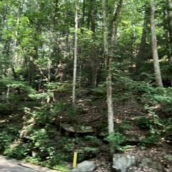
This overlook near Chattanooga apparently carries some significant Civil War history, but I didn't get much of a taste of that. I was there for the views. One can park near a splendid overlook of the river below. I underestimated the time to do a loop through the Rainbow Falls area and walk back. It was mostly a small path on fairly steep hills and parts required some care. That loop took me two hours or so. It delivered a variety of interesting plant and animal life. For the most part, I didn't get to see waterfalls but there were some around. There was no fee to get in, and it was remote enough not to be crowded on a day when a lot of things are crowded.

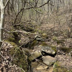
We went on a spur-of-the-moment adventure to find Signal Point overlook on a misty, rain-soaked day. Without a GPS, we just went off the beaten track and followed the small signs along the way, seeing large quaint old Plantation-style, Craftsman-style homes, as well as many 60s Modern marvels along the way. Once we reached the pinnacle, we found ourselves 672.57 feet up and surrounded by trees, dead quiet and a self-park area. We started the walk to the overlook. It's not a bad hike, but would have been better had we worn our proper hiking boots. We did not and there were many sets of wet stairs that were on a continuous decline, so we had to step gingerly. Except for when we reached Signal Point, where it became a bit rocky. The rocks were more slippery than the stairs, so we alternately walked in the grass. The view was worth it! Our breathtaking view once we got to Signal Point was enshrouded in clouds below us, hovering over the Tennessee River 'narrows' and trailing above. It is simply one of the most gorgeous things I have ever seen! History of Signal Point: During the Civil War in the Spring of 1863, Confederate forces cut off the telegraph lines to the city. Signal Point became a vantage point for US Army Signal Corp. They used telescopes and binoculars and sat in the trees to more closely view the passage. The 'Narrows' were a natural highway that extended for several miles downstream toward Paducah, Kentucky. This section was a treacherous stretch of rapids that made it almost impassable for large vessels that were bringing in reinforcements and supplies. The signals, comprising of square flags and torches, signified secret codes that were translated into numbers and words. Their signals flashed over to upriver 'Stringers Ridge'. Since there is a strong downriver current, the Union Army had to "warpup" the boats along man-made side channels lining the shore and physically pull the boats. The Union Army was led by Major General William T. Sherman. Tennessee Valley Authority (TVA) now operates a series of dams to allow navigation along the River. There is an additional trail in this park, directly to the right of the overlook, past the rock wall and beyond the cross-fencing. This trail is rated a 'strenuous' hike. It leads to Julia Falls, a wet-weather waterfall. Along the way are several notable rock formations, including 'Mushroom Rock' and a suspension bridge that leads to the waterfall. We will be back to tackle that more difficult trail once the leaves turn, which should be very soon. I would label this trek to the Point as 'Easy'', but keep in mind that rainy days will make the stairs slippery and a bit more difficult as there are no handrails. Wear hiking boots and bring a backpack with snacks and water! After we had our fill of fresh air, serene quiet and cool breezes, we made our ascent back. Once we were halfway back we discovered a dirt path leading directly to the parking. We decided to take that path and avoid the slippery stairs. A smart decision.

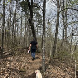
During my staycation this week, my dog buddy and I have been revisiting woodsy spots I enjoyed while growing up. Signal Point is one of them. Midday there were just a handful of people already on the nearby trail or pulling up. The temperature was perfect mid-70's. The sky was blue and clear. We enjoyed walking through the trees to the view to relax by for a bit. Highly recommended.

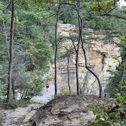
The entrance we took traveled through the forest where we caught glimpses of the overlook. There were steep declines and inclines. This hike would have been better to explore. This place would be better to hike when the ground is not wet. There was another path we took back to avoid all those stairs. The incline was sturdier when we hiked up. The hike started with several stairs but then continues as we hiked towards the overlook. The path curves and reaches some rockiness at the bottom and there were several puddles that made me hesitate. Then I stepped down into the overlook where we spent time. Julia Falls Overlook can be accessed from Signal Point and has a panoramic unobstructed looked into wide open space of the Tennessee River Gorge. There is a wooden staircase called "Mousetrap" drops a couple hundred feet before it levels out. This hike is difficult and is about a mile. There is a waterfall at the end. It The trail has sudden drops and narrow paths. Plus it has rocky terrains around the steep rock formations.


Surreal scenery! Definitely worth the trek. They did a fabulous job of creating a hiking trail that maintains the integrity of the nature scape it was created in. Majority dirt and rock trail, a few steps at the beginning. Short cut options that are more steep for those go-getters. The trail itself is fairly narrow but a ways from the ledge. It is predominantly shaded from the woods with the exception of the rock bluffs that you can walk out on. Beautiful rock bluffs to relax that overlook the Tennessee River. Stunning. As a visitor to Chattanooga, I would highly recommend this trail and visit over Rock City. It's free and personally I found it to be much more serene. I will definitely be returning whenever I am passing through. GO!


10 months ago
I parked here for the start of the Edward's Point trail via Crescent Ridge and found the parking lot pretty empty on a Monday morning around 9:30am. There are maybe 20 spots and the Signal Point overlook is right beside the restrooms and a short paved trail from parking. Worth a stop. read more


We were in Chattanooga for the weekend and wanted to visit Signal Mountain. In our limited research we heard that Signal Point was a special place to visit. We learned there are different ways to get to the top of Signal Point but all are pretty dang curvy and steep. We enjoyed our drive and the area appears to be very charming and peaceful. The Signal Point park is located adjacent to a residential neighborhood and is very well marked and easy to find. There are approximately 20 designated parking spots. It was a very cold afternoon so we bundled up and walked down to the overlook. It was really beautiful, with the Tennessee River flowing below and the array of rock ridges. The history of the area is incredible as well, there are signs within the park to help educate guests on the challenges of those who came before us. We learned that during the Civil War the river was a natural highway through the region but sections of rapids were impassable for large vessels. Supply boats bound for Chattanooga had to be pulled by ropes through the man-made side channels which strengthened the Union army for Sherman's advance on Atlanta in 1864. We also learned when the Confederate forces laid siege to Chattanooga in September 1863, they cut off telegraph lines to the city. The Federals, in order to move messages from Chattanooga, a series of signal stations were established. One of these stations was Signal Point. Incredible history and beautiful location all in one. We would highly recommend to others visiting or living in the area. read more


This overlook near Chattanooga apparently carries some significant Civil War history, but I didn't get much of a taste of that. I was there for the views. One can park near a splendid overlook of the river below. I underestimated the time to do a loop through the Rainbow Falls area and walk back. It was mostly a small path on fairly steep hills and parts required some care. That loop took me two hours or so. It delivered a variety of interesting plant and animal life. For the most part, I didn't get to see waterfalls but there were some around. There was no fee to get in, and it was remote enough not to be crowded on a day when a lot of things are crowded. read more


We went on a spur-of-the-moment adventure to find Signal Point overlook on a misty, rain-soaked day. Without a GPS, we just went off the beaten track and followed the small signs along the way, seeing large quaint old Plantation-style, Craftsman-style homes, as well as many 60s Modern marvels along the way. Once we reached the pinnacle, we found ourselves 672.57 feet up and surrounded by trees, dead quiet and a self-park area. We started the walk to the overlook. It's not a bad hike, but would have been better had we worn our proper hiking boots. We did not and there were many sets of wet stairs that were on a continuous decline, so we had to step gingerly. Except for when we reached Signal Point, where it became a bit rocky. The rocks were more slippery than the stairs, so we alternately walked in the grass. The view was worth it! Our breathtaking view once we got to Signal Point was enshrouded in clouds below us, hovering over the Tennessee River 'narrows' and trailing above. It is simply one of the most gorgeous things I have ever seen! History of Signal Point: During the Civil War in the Spring of 1863, Confederate forces cut off the telegraph lines to the city. Signal Point became a vantage point for US Army Signal Corp. They used telescopes and binoculars and sat in the trees to more closely view the passage. The 'Narrows' were a natural highway that extended for several miles downstream toward Paducah, Kentucky. This section was a treacherous stretch of rapids that made it almost impassable for large vessels that were bringing in reinforcements and supplies. The signals, comprising of square flags and torches, signified secret codes that were translated into numbers and words. Their signals flashed over to upriver 'Stringers Ridge'. Since there is a strong downriver current, the Union Army had to "warpup" the boats along man-made side channels lining the shore and physically pull the boats. The Union Army was led by Major General William T. Sherman. Tennessee Valley Authority (TVA) now operates a series of dams to allow navigation along the River. There is an additional trail in this park, directly to the right of the overlook, past the rock wall and beyond the cross-fencing. This trail is rated a 'strenuous' hike. It leads to Julia Falls, a wet-weather waterfall. Along the way are several notable rock formations, including 'Mushroom Rock' and a suspension bridge that leads to the waterfall. We will be back to tackle that more difficult trail once the leaves turn, which should be very soon. I would label this trek to the Point as 'Easy'', but keep in mind that rainy days will make the stairs slippery and a bit more difficult as there are no handrails. Wear hiking boots and bring a backpack with snacks and water! After we had our fill of fresh air, serene quiet and cool breezes, we made our ascent back. Once we were halfway back we discovered a dirt path leading directly to the parking. We decided to take that path and avoid the slippery stairs. A smart decision. read more


) - Hiking Near Me - Signal Mountain, Tennessee")


During my staycation this week, my dog buddy and I have been revisiting woodsy spots I enjoyed while growing up. Signal Point is one of them. Midday there were just a handful of people already on the nearby trail or pulling up. The temperature was perfect mid-70's. The sky was blue and clear. We enjoyed walking through the trees to the view to relax by for a bit. Highly recommended. read more


5 years ago
The entrance we took traveled through the forest where we caught glimpses of the overlook. There were steep declines and inclines. This hike would have been better to explore. This place would be better to hike when the ground is not wet. There was another path we took back to avoid all those stairs. The incline was sturdier when we hiked up. The hike started with several stairs but then continues as we hiked towards the overlook. The path curves and reaches some rockiness at the bottom and there were several puddles that made me hesitate. Then I stepped down into the overlook where we spent time. Julia Falls Overlook can be accessed from Signal Point and has a panoramic unobstructed looked into wide open space of the Tennessee River Gorge. There is a wooden staircase called "Mousetrap" drops a couple hundred feet before it levels out. This hike is difficult and is about a mile. There is a waterfall at the end. It The trail has sudden drops and narrow paths. Plus it has rocky terrains around the steep rock formations. read more


3 years ago
I went on this hike a Tuesday morning. Not many people were there, so the hike was very serene and enjoyable. The trail confused me a bit, but I would definitely do it again. read more


12 years ago
Surreal scenery! Definitely worth the trek. They did a fabulous job of creating a hiking trail that maintains the integrity of the nature scape it was created in. Majority dirt and rock trail, a few steps at the beginning. Short cut options that are more steep for those go-getters. The trail itself is fairly narrow but a ways from the ledge. It is predominantly shaded from the woods with the exception of the rock bluffs that you can walk out on. Beautiful rock bluffs to relax that overlook the Tennessee River. Stunning. As a visitor to Chattanooga, I would highly recommend this trail and visit over Rock City. It's free and personally I found it to be much more serene. I will definitely be returning whenever I am passing through. GO! read more


8 years ago
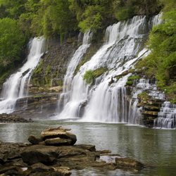
Moderate trail with short hike to the falls, while I was there a few people were swimming around so bring swimming clothes and something to change in to. I'd recommend wearing water shoes since the water is fairly murky in some parts. read more


15 years ago
12 years ago
This is an amazing trail, and even more beautiful in the fall. I agree with other yelpers that it is more of an intermediate hike, so I wouldn't recommend this for children. It has many breathtaking views of the river and mountainside, and has a nice mix of ups and downs so you won't get too tired too quickly. One word of warning, save some energy for the stairs on the way back. The steps are very large/steep, so it takes quite a bit of energy to get back to the starting point. One other great feature is there is a parking lot for this trail, which many others on signal point mountain do not have. I will definitely be back! read more


6 years ago
10 years ago
More info about Signal Point
Ask the Community - Signal Point
Review Highlights - Signal Point


Signal Point - hiking - Updated July 2026
Best of Signal Mountain
People found Signal Point by searching for…
Hiking Trails With Waterfalls in Signal Mountain, TN
Scenic Overlook in Signal Mountain, TN
Things to Do in Signal Mountain, TN
Scenic View in Signal Mountain, TN
Scenic Drive in Signal Mountain, TN
Churches in Signal Mountain, TN
Places to Take Pictures in Signal Mountain, TN
Waterfalls in Signal Mountain, TN
Plantation Tours in Signal Mountain, TN
Watch Sunset in Signal Mountain, TN
Rock Quarry in Signal Mountain, TN
Parks for Kids in Signal Mountain, TN
Swimming in Signal Mountain, TN
Walking Trails in Signal Mountain, TN
Things to Do on a Rainy Day in Signal Mountain, TN
Beautiful Views in Signal Mountain, TN
Secret Spots in Signal Mountain, TN
Lookout Points in Signal Mountain, TN
Running Trails in Signal Mountain, TN
Swimming Lakes in Signal Mountain, TN
Trending Searches in Signal Mountain, TN
Cliff Jumping near Signal Point
Dog Friendly Beaches near Signal Point
Dog Friendly Trails near Signal Point
Free Picnic Areas near Signal Point
Historical Sites near Signal Point
Jet Ski Rental near Signal Point
Kayak Rental near Signal Point
Landmarks & Historical Buildings near Signal Point
Off Road Trails near Signal Point
Outdoor Activities near Signal Point
Parks For Picnics near Signal Point
Picnic Spots near Signal Point
Places To Swim near Signal Point
Pool Day Pass near Signal Point
Public Shower near Signal Point
Public Swimming Pools near Signal Point
River Swimming near Signal Point
River Tubing near Signal Point
Scenic Overlook near Signal Point
Scenic Restaurants near Signal Point
Soccer Store near Signal Point
Swimming Holes near Signal Point
Swimming Lakes near Signal Point
Things To See near Signal Point
U Pick Farms near Signal Point
Browse Nearby
BEST of Signal Mountain, Tennessee Restaurants near Signal Point
BEST of Signal Mountain, Tennessee Coffee near Signal Point
BEST of Signal Mountain, Tennessee Things to Do near Signal Point
BEST of Signal Mountain, Tennessee Walking Trails near Signal Point
BEST of Signal Mountain, Tennessee Parks near Signal Point
BEST of Signal Mountain, Tennessee Caves near Signal Point
BEST of Signal Mountain, Tennessee Breakfast near Signal Point
BEST of Signal Mountain, Tennessee Ski Resorts near Signal Point
BEST of Signal Mountain, Tennessee Campgrounds near Signal Point
Browse Brands
Related Searches in Signal Mountain, TN
Affordable Kayak Rental Services in Signal Mountain, Tennessee
Best Dog Hiking Trails Around Signal Mountain, Tennessee
Best Fishing Locations and Guides in Signal Mountain, Tennessee
Best Fun Things to Do in Signal Mountain, Tennessee
Best Lookout Points to Visit in Signal Mountain, Tennessee
Best Places for Horseback Riding in Signal Mountain, Tennessee
Best Sightseeing Experiences Available in Signal Mountain, Tennessee
Book Engaging Historical Tours in Signal Mountain, Tennessee
Check Out Off Road Trails in Signal Mountain, Tennessee
Discover Charming Historic Homes in Signal Mountain, Tennessee
Discover Dog Friendly Trails to Explore in Signal Mountain, Tennessee
Discover Famous Monuments in Signal Mountain, Tennessee
Discover Popular Bike Trails in Signal Mountain, Tennessee
Discover Popular Landmarks in Signal Mountain, Tennessee
Discover Popular Photo Spots in Signal Mountain, Tennessee
Discover Top Nature Parks to Visit in Signal Mountain, Tennessee
Discover Top Points of Interest in Signal Mountain, Tennessee
Discover a Hiking Trail in Signal Mountain, Tennessee
Discover the Best Caves to Explore in Signal Mountain, Tennessee
Discover the Best Fishing Lake in Signal Mountain, Tennessee
Discover the Best Military Museum in Signal Mountain, Tennessee
Discover the Best Night Hike Trails in Signal Mountain, Tennessee
Dog-Friendly Hikes With Dogs in Signal Mountain, Tennessee
Enjoy Camping Adventures Around Signal Mountain, Tennessee
Enjoy Exciting Mountain Biking Adventures in Signal Mountain, Tennessee
Enjoy Kayaking Adventures in Signal Mountain, Tennessee
Enjoy Off Leash Dog Hikes in Signal Mountain, Tennessee
Enjoy Scenic Places to Walk in Signal Mountain, Tennessee
Enjoy Tent Camping Spots Around Signal Mountain, Tennessee
Enjoy a Beautiful Waterfall Hike in Signal Mountain, Tennessee
Enjoy the Best Walking Trails in Signal Mountain, Tennessee
Explore Beautiful Botanical Gardens in Signal Mountain, Tennessee
Explore Beautiful Castles and Landmarks in Signal Mountain, Tennessee
Explore Beautiful Parks and Green Spaces in Signal Mountain, Tennessee
Explore Children's Museums Near Signal Mountain, Tennessee
Explore Easy Hikes Perfect for All in Signal Mountain, Tennessee
Explore Free Things to Do Around Signal Mountain, Tennessee
Explore Fun Activities to Do in Signal Mountain, Tennessee
Explore Fun Field Trips in Signal Mountain, Tennessee
Explore Peaceful Bird Sanctuaries in Signal Mountain, Tennessee
Explore Popular Campgrounds Near Signal Mountain, Tennessee
Explore Popular Scenic Overlook Points in Signal Mountain, Tennessee
Explore Popular State Park Destinations in Signal Mountain, Tennessee
Explore Secret Spots Worth Visiting in Signal Mountain, Tennessee
Explore Top Art Galleries Located in Signal Mountain, Tennessee
Explore Top Dog Parks in Signal Mountain, Tennessee Near You
Explore Venues & Event Spaces in Signal Mountain, Tennessee
Explore the Best Swimming Holes Around Signal Mountain, Tennessee
Browse Articles
People who viewed Signal Point also viewed
Raccoon Mountain Recreation Area and Trails
25 reviews
Booker T Washington State Park
8 reviews
Experience Chattanooga
5 reviews
Ross' Landing Park
8 reviews
Stringer's Ridge Park
8 reviews
The Chattanooga Riverfront
53 reviews
Ruby Falls
948 reviews
Falling Water Falls Trail
4 reviews
Foster Falls Small Wild Area
12 reviews
Outdoor Chattanooga
6 reviews