Cancel

    Open app

    Search

    St Xavier Nature Preserve

    5.0 (1 review)

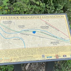
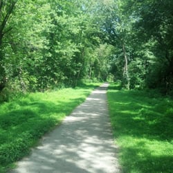
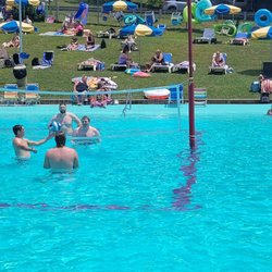
    St Xavier Nature Preserve Photos

    Recommended Reviews - St Xavier Nature Preserve

    Your trust is our priority, so businesses can't pay to alter or remove their reviews. Learn more about reviews.
    Yelp app icon
    Browse more easily on the app
    Review Feed Illustration

    3 years ago

    Helpful 0
    Thanks 0
    Love this 0
    Oh no 0

    Verify this business for free

    People searched for Parks 504 times last month within 15 miles of this business.

    Verify this business

    Ghost Town Trail

    Ghost Town Trail

    4.7
    (3 reviews)
    17.5 mi

    This is a gorgeous trail. It is very easy and you can walk as far as you want. The trail is well…read moremaintained (mostly crushed gravel) and a fun place to go for a walk, run, or bike ride. You will see beautiful forest areas along the way.

    Well another biking milestone for yours truly and her husband Rick. We did the entire 60+ mile…read moreround trip between Black Lick and Ebensburg on the Ghost Town Trail! It took all day, I'm still saddle sore and my leg muscles ache a little, but it was totally worth it. Besides, we're building up our strengths so we can do the 120+ miles of the Great Allegheny Passage Trail between McKeesport and Cumberland, MD. There's not too much more I can write about the trail. Last year we rode the Black Lick to Nanty Glo segment of the trail and most points of interest are between those two towns. Still, the remaining segment between Nanty Glo and Ebensburg makes for a pleasant ride. I did find out a few other things about the trail since the last time we rode it. Just east of Black Lick, the trail passes a salvage yard of discarded rail cars. These almost seamlessly blend into the scenery and they're altogether appropriate because this is a rails-to-trails conversion. Between Dilltown and Vintondale the creek has a bright red color because of the acid drainage from the coal mines. At several points you will exit the cool green forested surroundings and experience an "ecological disaster area", a legacy of the mining era. You'll see the remains of some slag dumps, which have an eerie beauty to them. Keep an eye out for the AMD & Art Park (AMD stands for Acid Mine Damage). One other thing to consider. This trail goes through some state game lands. During hunting season, you should wear brightly colored clothing. Riding the Ghost Town Trail can be very rewarding. Plan to take the whole day and be sure to enjoy the sights along the way.

    Photos
    Ghost Town Trail
    The trail is maintained enough to bring a tricycle
    The trail is maintained enough to bring a tricycle
    Ghost Town Trail

    See all

    Coal and Coke Trail

    Coal and Coke Trail

    4.5
    (2 reviews)
    11.5 mi

    The Coal & Coke Trail is a neat little biking and hiking trail in Westmoreland County connecting…read moreMount Pleasant with Scottdale. A mere 5 miles in length, it's one of the few Rails-to-Trails I hadn't covered yet. Really, I couldn't justify the time or gas money to do a 10 mile round trip bike ride. A 10 mile hike is of course another story! And that's just what I did as part of my employer's wellness program. I planned the whole thing and of course headed up the hardy group of hikers able to complete the entire 10 mile round trip. The trail begins and ends in city parks at both ends. We began at Willows Park in Mount Pleasant. The address I gave you above is the parking lot and it's based on information from www.traillink.com Drinking water and restrooms are available in the park, but the restrooms appear to be closed in winter. We began by working our way southbound. The trail was built on the roadbed of a Pennsylvania RR branch. As ts name implies, the railroad hauled coke ad coal over the line. The railroad was abandoned for many years, however after 8 years of planning, the trail opened in 2007. Upon leaving town, we hiked through some scenic wooded areas to the town of Bridgeport. At one point we noticed the trail paralleling an active rail line. The forest here is old growth and we crossed one of a few small streams. Beyond the town of Bridgeport, we again entered the woodlands while paralleling Jacobs Creek. Curving to the west as we approached Scottdale, we arrived at the scenic high point of the day. The sewage treatment plant. Yep! The trail even goes through plant's parking lot and is routed onto Sewage Treatment Lane! Well no worries--we crossed Old US 119 and then ducked under the new highway before entering our last stretch of woodlands. Part of the trail is incomplete at Scottdale, so we had to walk down Mildred Street , Bessemer Street, and Mt. Pleasant Road (they're actually all the same street) before reaching Kendi Park. The trail resumes briefly here but this was our rest stop and turnaround point. So this is a pleasant and relatively easy trail to hike or bike. Just remember, there aren't any places to obtain food or water along the path, so be sure to bring adequate supplies of each.

    Great place to walk. You can choose to challenge yourself or take it easy. Got lots of great pics…read moreas well

    Photos
    Quaint short trail.. Very nice

    See all

    Quaint short trail.. Very nice
    West Penn Trail

    West Penn Trail

    4.7
    (3 reviews)
    14.2 mi

    If you're looking for one the best bike trails in SW Pennsylvania, you should check out the is a…read more17-mile long West Penn Trail between Saltsburg and the Westinghouse trailhead near Blairsville. My husband Rick and I are avid trail riders and we did just that this past weekend. We'd FINALLY gotten a decent day in an otherwise crummy spring to go riding. So we prepped ourselves. Trail snacks and sandwiches? Check! Tool kit? Check! Tire repair kit? Check! Pumps air and insulin (I'm a type-1 diabetic)? Check! Okay, let's roll! Please note the address I gave you is the approximate location of the trailhead in Saltsburg. I used Google Maps to come up with the approximate address. The Kiski Section of the trail extends about another two miles north of here, dead ending at Urban Road. Plus Rick and I didn't start our ride here. We began our trip on the connecting Westmoreland Heritage Trail. Oh but what a glorious ride we had! The trail is a rails-to-trails conversion which mostly follows the Conemaugh River. It was an active railroad line until the 1970s when the Penn-Central Railway Co. abandoned it. It's the trail for you if you love old dam sites and stone arch bridges. We made a crossing of four out of the five bridges. We picked up the trail in Saltsburg, making our wy east. One of the first thing we learned is that an old canal paralleled the railroad and river. We saw plenty of sites relating to the old canal including lock sites, tunnel sites, and culverts (a shout out to my Yelp friend Mike O--no not Culver's, the hamburger chain near you!). After White Station we saw a little bit of the canal bed with some standing water remaining. Then about a couple miles east of there, we made a sharp left, following Elder's Run. Here we saw two highlights on the initial segment of the trip, a remaining building from the Atlas Powder Works, and the Elder's Run Culvert which is a tunnel that we passed through. At this point the trail appears to follow the old canal bed. Continuing our way east, we come up to an area that I think was my favorite on the whole trip, the Conemaugh Dam. Here the trail makes a number of turns, loops, and switchbacks to get around the dam. You'll find a lot of sites here. Working your way to the south in rapid succession you'll find the 1864 Railroad Grade, the 1954 High Level Bridge, the Pennsylvania Canal Site, the 1936 flood marker, Tunnleton, and the West Portal of the Canal Tunnel. In this area you'll also find a State Recreation Area with two parking lots for the trail and two sets of restrooms if you need them. In picking up the route of the old railroad, we cross three of the stone arch bridges spanning the Conemaugh River. Some people consider these bridges the scenic highlight, so a photostop is necessary if you brought your camera. We wound up our trip at the Social Hall area. Here the sites include a water spring, an old highway abutment, and the old Social Hall RR Station site, now used as a picnic grove. That was fine by us. We stopped there and relaxed, lunching on our sandwiches we packed. Then it was time to head back. The West Penn Trail is a fantastic ride but there are a few things to consider. First of all, this is a difficult trail in places. While much of the trail is easy to moderate, be careful of the slope at the Conemaugh River Dam section. It's a few miles long and way more challenging than the rest of the trail. There are many changes in elevation and some pretty good extended climbs. You go down to the river and across a stone bridge then a fairly long climb up to the top. I recommend that you be in decent shape when taking this trail. Remember too, please listen to your body. If you start getting tired, remember that no matter where you are, you're really only halfway there 'cos you gotta turn around and go back. Make sure your bike is in tip-top mechanical condition too. I strongly recommend a mountain bike for this trail. Road/city bikes are not recommended. Also be sure to pack supplies. Snacks such as nuts and dried fruits are terrific. If you want fresh fruit, apples travel well. If you're packing a lunch, a peanut butter-n-jelly sandwich is always good. And don't be in a hurry when riding this trail. Stop and enjoy the sites. Rick and I did a 40+ mile round trip and it took us all day!

    This is a really nice trail. It has a beautiful view when you ride over the Conemaugh Dam. There…read moreare some steep and challenging hills near the dam. The rest of the trail is only a slight grade. Also, the trail joins the Westmoreland Heritage Trail in Saltsburg. The Westmoreland Heritage Trail starts in Slickville and is 6 miles. It is a nice way to add a couple extra miles.

    Photos
    West Penn Trail
    A guy went by with a leaf blower at the recreation center at Conemaugh Dam.
    A guy went by with a leaf blower at the recreation center at Conemaugh Dam.
    West Penn Trail

    See all

    Laurel Hill State Park

    Laurel Hill State Park

    4.6
    (14 reviews)
    21.4 mi

    As if there wasn't enough parks in the Laurel Highlands, there is Laurel Hill State Park a 3,935…read moreacre natural area of beautiful forest, overlooks, ponds and streams. My recent visit was promising at first, but the rain just kept coming all day long and it "dampened" my spirits completely. I stopped by the main office and got directions to the Jones Mill Dam. Since it was raining so much I gave it some time to clear up, but to no avail. This park is certainly worth checking out and it will be super beautiful later on in the Spring. The wood frogs, spring peepers and other animals will be active. On the same road that this park lies on is two other parks: Kooser State Park and Laurel Ridge State Park, so it is possible to hit those up while in the area. I will certainly make the trip out here later on towards May.

    I was staying at Hidden Valley recently and I was looking for a cool place to hike in the area that…read moreI hadn't been to before and I happen to discover this gem. What a great spot for a hike, but an even better place for a swim, relaxing, a picnic on the grass or some sun on the sand by the water. So after we arrived we hit the trail that ran along the water while taking in the small but beautiful lake. We then proceeded to head into the woods. It was a great little hike and the trails were very easy. After we were done hiking we got the huge blanket and the cooler with snacks and drinks in it out of the car and headed over to a shaded spot under the trees. We sat in the grass area in the left corner of the parking lot and listened to music, ate, drank and enjoyed each other's company for a good while. Then after that we packed up our stuff in the car and headed down to the water and enjoyed the lake which is very clean and refreshing and the scenery is absolutely beautiful. I love that they have sand and everyone looked so happy. They also have an area where you can purchase food and beverages but they also have many other great amenities which I am sure can be discovered on here or on their website. I am so glad I discovered this place. I will most definitely be stopping by again when I am in the area. Enjoy :)

    Photos
    A wood frog in their vernal pool near the stream.
    A wood frog in their vernal pool near the stream.
    Laurel Hill State Park
    Laurel Hill State Park

    See all

    St Xavier Nature Preserve - parks - Updated June 2026

    Loading...
    Loading...
    Loading...