Cancel

    Open app

    Search

    Steel Valley Trail

    4.0 (4 reviews)

    Steel Valley Trail Photos

    Recommended Reviews - Steel Valley Trail

    Your trust is our priority, so businesses can't pay to alter or remove their reviews. Learn more about reviews.
    Yelp app icon
    Browse more easily on the app
    Review Feed Illustration

    2 years ago

    Helpful 2
    Thanks 1
    Love this 1
    Oh no 0

    6 years ago

    Helpful 0
    Thanks 0
    Love this 0
    Oh no 0
    Photo of Susan D.
    202
    828
    14

    15 years ago

    Helpful 3
    Thanks 0
    Love this 2
    Oh no 0
    Photo of Troy B.
    417
    854
    39430

    10 years ago

    Helpful 1
    Thanks 0
    Love this 2
    Oh no 0

    Verify this business for free

    People searched for Hiking 2,346 times last month within 15 miles of this business.

    Verify this business

    Dead Man's Hollow - The first early signs of Spring!  It looks like it will be a good one.  Beautiful crocus flower near the catfish pond area.

    Dead Man's Hollow

    4.1(9 reviews)
    10.6 mi

    This lovely conservation area is 450 acres of beautiful forest with lots to see and a very shadowy…read morepast. The ruins of an old pipe factory are very visible and there are informative signs that tell the story. These occurrences took place in the 1800's. There is history of criminals murdered, accidental death(pipe factory), a hanging, an explosion, a drowning, a giant snake sighting, all taking place in the park. For this reason many people think that the sight is haunted by the people who met their fate here. I hate to burst the excitement, but I have never experienced ghosts, or any other paranormal activity while spending time there. In fact, despite it's dark past Dead Man's Hollow is a very tranquil place. If you have been there during May when Spring season really kicks off you will see tons of wildflowers that are spectacular. The pipe factory had a fire and the ground was burned. This happens to be very good for re-growth and as a result we get to experience a lot of beautiful flora. Also, the old pipe factory remains are covered with cool graffiti. The trails are at times narrow, but they are very clean. You are at some point going to climb up and down hills, so it is a very good workout. I would say that the hiking is a bit more challenging. To find it I would suggest searching via a trailhead name and not just the park name. One example would be "cat fish pond trail." There is a nice parking area near that trailhead. There is also another parking area on the other side of the park(more on that later). This other side is closer to the ruins.

    We checked out the catfish pond today. It looked promising at first but soon discovered that there…read moreis very little accessibility to fish there. The spots that are open are at an incline sloped towards the pond and are very slippery and hazardous. I do not recommend taking young kids there. My daughter and I fished for an hour or so and only saw bluegill in the 3-4" range and smaller minnows. We used lures and worms and had many bites but the fish were too small to get hooked. We did see many water turtles and even a few babies whose shell was about 2-3" in diameter. We also saw one large snapping turtle appear for a few seconds. There are also a bunch of bullfrog minnows whose bodies were the size of golf balls (early June). It's a cool place to see but we won't be returning to fish.

    Photos
    Dead Man's Hollow - Beautiful crocus flowers near the catfish pond area.

    Beautiful crocus flowers near the catfish pond area.

    Dead Man's Hollow - The "cloth of gold" crocus flower.

    The "cloth of gold" crocus flower.

    Dead Man's Hollow - Just two dudes hiking the trail.

    See all

    Just two dudes hiking the trail.

    Great Allegheny Passage - Waterfront

    Great Allegheny Passage

    5.0(5 reviews)
    10.0 mi

    I can't believe I haven't reviewed the Great Allegheny Passage Rail Trail until now. It is such a…read morejewel and where I spend a lot of my free time riding my bicycle, especially during this crazy time we're in at the moment with COVID-19. (Note that it is not just for bicycles; walkers and runners also utilize the trail, just not motorized vehicles, so you don't have to compete with cars.) I won't go into all the details of the trail; that is interesting in itself regarding its history, how long it's taken to get the land for the different sections, its steepness grade or lack thereof, all the different towns it goes through, etc. For all of that, I'll give you the very useful link:https://gaptrail.org/ What I will do is give you some highlights and what makes it a jewel to me. It is 150 miles of mostly packed crushed limestone (with a bit of it paved between Pittsburgh and McKeesport) from the Pittsburgh Point Fountain (there's a marker on the ground near it) to Cumberland, MD. Most of it is on what used to be railroad beds and a bit of it is on streets (near downtown Pittsburgh and some in McKeesport). Because of the railroad bed usage, the path follows that grade (meaning gradual steepness with the sharpest elevation gain/loss being between the Eastern Continental Divide and Cumberland). What all the preceding paragraph means is that it is a quite doable trail and comfortable to ride. The packed gravel means it is pretty close to riding on a road surface because it is so packed. The only time that is not true is usually after a downpour when there might be parts of it that retain water. The grade following the grade of the railroads means the gradual incline (if you're going from Pittsburgh to Cumberland) is pretty gradual and a steady 10mph is doable. From the Continental Divide to Cumberland is downhill and is quite easy; coming back is a bit more strenuous -- see the afore-mentioned link to see mileage and grade of that section. I remember when I first heard about the trail; I had no concept of a rail trail to begin with so did not know what to expect in the least. If you're in the same boat, I will say that the trail is open from sun-up to sun-down, there are no street lights lighting the path on purpose though where it travels in spots may have lights for other purposes. It is mostly wide enough for say three bikes across, but don't do that! There is trail etiquette; learn it for everyone's safety and enjoyment -- stay to the right, single file and if you are riding 2 across for any reason, then pay close attention to passers; you'll need to be sure to listen to "on your left' or a bell or some audible signal that someone needs to pass you. On the converse side, if you're passing, pass on the left and issue an audible signal, etc. Just share the trail! Also, some parts of the trail are shaded by trees lining the trail; other parts are in the sun for extended periods so wear sunscreen. There are amenities all along the trail. That was important for me as a first-timer to know because I couldn't grasp at first if it was secluded, wilderness, or what. The GAP trail has so many towns, ballfields, restaurants, ice cream stands, portable restrooms every so many miles and parking trailheads plus a number of other cyclists on the trail that you won't feel that isolated and except for a couple spots (downtown Pittsburgh or Ohiopyle for example) you won't feel the trail is too crowded, either. Take water, snacks, an extra tube and you'll find you'll have what you need. Do you need certain size tires (mountain bike/hybrid/road bike)? Some people debate that. I have a hybrid bike and am happy enough. Favorite parts of the trail for me? I love the section between Myersdale, PA and Frostburg, MD. In that section is the Mason-Dixon line and the Eastern Continental Divide. I also love riding between Homestead and downtown Pittsburgh. Along that route is the Hays Eagle nest. And being downtown Pittsburgh on my bike is so much easier than navigating and parking a car. And when you want to go further on your adventure than Cumberland, MD? It hooks up directly with the C & O Tow Path for another 184.5 miles to get you all the way to Washington, D.C. for a total of 334.5 miles. Many of us have taken several days in one stretch to ride the entire length between Pittsburgh and D.C. and it is quite the trip, and well worthwhile, as are many of the many sections of the GAP trail. It has such unique personalities with wildlife (there are deer, owls, groundhogs, rabbits just to name a few) and so many wildflowers along the way. You're following rivers along the route, as well, plus get to take advantage of PA's lovely state park, Ohiopyle. There are several campsites, hotels, and bed and breakfasts along the way, too. I could go on and on but I recommend talking to others who have ridden the trail, look up Facebook webpages related to the GAP, get a trail book and google for more info.

    We are so fortunate to have this trail run right into downtown Pittsburgh. Today I rode from…read moredowntown to Homestead and back. 13 miles and, boy is my butt sore! Someday I hope to ride all the way to DC. They'll probably have to bring me home in a giant butt sling, but I don't care! Riding along the river is so beautiful on a warm fall day. Whether you go five miles or five hundred, don't miss an opportunity to bike, walk, or skate along this treasured trail.

    Photos
    Great Allegheny Passage
    Great Allegheny Passage
    Great Allegheny Passage - Crossing the Hot Metal Bridge to get from Downtown to the Great Allegheny Passage Trail.

    See all

    Crossing the Hot Metal Bridge to get from Downtown to the Great Allegheny Passage Trail.

    Frick Park - A mourning dove outside of the Frick Environmental Center.

    Frick Park

    4.6(106 reviews)
    5.2 miSquirrel Hill

    City parks in general, but Frick, Schenley, and Riverview in particular are amazing recreational…read moreassets that are unequalled in other metro areas. I was fortunate and privileged to grow up with Frick as my backyard and walked all over the place before graduating to riding mountain bikes on the trails when the sport was in its infancy. Later, I ran high school cross-country races in Schenley and trained in Frick Park. Nowadays, we enjoy the flowers, wildlife, and groomed and maintained trails. I never appreciated how unique, rare, and amazing the parks are until I moved away and it's so great to see them treated as the unique assets they truly are.

    Frick Park is a dense network of interconnected trails that helps define Pittsburgh as a city of…read moreparks. I keep coming back and exploring different paths, only to realize there's always more to discover. It's one of those places where you can return again and again and still find something new, which makes it feel really special to me. The way the trails connect is one of my favorite things. Nine Mile Run flows into Deer Creek, which then connects into Tranquil Trail, creating an easy, continuous experience through the park. And thats just one corner of the park. While bathrooms are not abundant, you will occasionally find a porta potty, and there is often trash cans and benches toward the entrances and parking lots of the trail as well. Overall it's just a wonderful place to spend a sunny afternoon, and I really hope spaces like this continue to be preserved as an important part of Pittsburgh's identity and history.

    Photos
    Frick Park - What a rare sight to see these snowdrop flowers in January.

    What a rare sight to see these snowdrop flowers in January.

    Frick Park - Entrance across from the Frick Museum

    Entrance across from the Frick Museum

    Frick Park - Flat Path behind the Frick Museum.

    See all

    Flat Path behind the Frick Museum.

    Nine Mile Run Watershed Association - The Nine Mile Run & StormWorks office, located at the corner of Pennwood Ave and Vassar Way

    Nine Mile Run Watershed Association

    4.3(3 reviews)
    6.2 mi

    The Nine Mile Run is a small stream that connects Frick Park with the Monongahela River. Chances…read moreare you've driven over it, biked over it, or walked over it but you wouldn't know it. You can cross it in hundreds of places but you won't need a bridge. That's because the stream runs almost entirely underground, emerging in Frick Park. The address shown is approximately where it emerges. People have lived in the Nine Mile Run Watershed for many centuries. The Native American Deleware tribe resided here until the 1600s. LIkely they hunted and fished here because it has been home to many species. When the Europeans arrived, they formed small communities and the region prospered, especially with the arrival of the steel industry. When that industry declined in the 1970s the area suffered a sizeable population loss. It is now reinventing itself into a post-industrial environment with plenty of green space. Nine Mile Run flows through Wilkinsburg, Swissvale, Edgewood, and the eastern most portion of Squirrel Hill. It is currently unhealthy. As the 20th Century began, streams were often used to transport trash and sewage and most of the Run was piped into underground culverts. The Run often gives off a stench of sewage after a rain. That's because over a quarter of the watershed is covered by impermeable surfaces such as pavement and sidewalks which do not allow rainwater to filter into the soil. Whenever it rains, Nine Mile Run becomes overwhelmed with water runoff, causing erosion, destruction of animal habitat, and environmental degradation. This is not helped by Pittsburgh's outdated sewer system. Just how antiquated is the system? No permits for the construction of the type of sewers Pittsburgh uses have been issued since the 1930s. Nine Mile Run was also deeply affected by the steel industry. While the mills kept us fed and put our kids thru school, they did heavy damage to the environment. Nine Mile Run Wateshed contained no mills, but millions of tons of slag were dumped along the edge of the stream. In 1922, Duquesne Slag Company bought 94 acres of the Nine Mile Run Watershed and over the years bought more and more land. Despite this being zoned a residential area, Duquesne Slag continued dumping. It's estimated that some 200 million tons of slag rest in the area. Today the Nine Mile Run Watershed is in the middle of decade long restoration project. Reclamation projects have resulted in new housing, vegetation, and greenways on the former slag heap. The Watershed is currently home to 250 plant species, 22 different mammals, and 189 types of birds. A 100 acre greenway is being built to connect Frick Park with the Mon River. A trail has been built along the stream and it will eventually link up with the Duck Hollow Trail and a direct connection will be made to the trail system in the park. My Girlfriends and I hike Frick Park's extensive trails and we are looking forward to being able to hike all the way from Reynolds Street down to the Mon.

    The Nine-Mile run Watershed is located in the Regent Square/Edgewood area of Pittsburgh and covers…read more~6.5 square miles. It boasts a stream and breathtaking scenery. It includes hiking trails and the largest urban stream restoration completed by the Army Corp of Engineers. The Nine Mile Run Watershed Association, is s non-profit organization located at 321 Pennwood Ave., supporting preservation of the site. They maintain a Facebook site and sponsor social and fund-raising events.

    Photos
    Nine Mile Run Watershed Association - Nine Mile Run staff enjoying the Nine Mile Run Bike Tour & Block Party 2017.

    Nine Mile Run staff enjoying the Nine Mile Run Bike Tour & Block Party 2017.

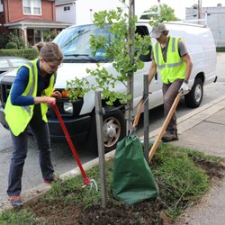
    Nine Mile Run Watershed Association - NMRWA staff removing grass to lay down mulch for a NMRWA tree planted in 2016.

    NMRWA staff removing grass to lay down mulch for a NMRWA tree planted in 2016.

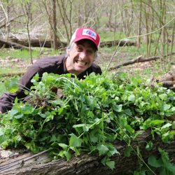
    Nine Mile Run Watershed Association - An Urban EcoSteward poses with a pile of uprooted garlic mustard in Frick Park.

    See all

    An Urban EcoSteward poses with a pile of uprooted garlic mustard in Frick Park.

    Panther Hollow Trail - Lower Trail

    Panther Hollow Trail

    4.3(6 reviews)
    3.2 miSquirrel Hill

    When I lived in Bloomfield, I'd often walk over to Oakland and the Panther Hollow Trail. The trail…read moreis part of the Three Rivers Heritage Trail system. It's well-maintained and kept clean. The trail is perfect for walking and biking. Whether you're out for a casual & leisurely walk or to get your jog on, it's a perfect trail. Peaceful and serene, surrounded by nature in the heart of a bustling city.

    Given that I live in N. Oakland, this trail is my gateway to the Three Rivers Heritage Trail…read moreSystem, a.k.a. the bike trails that run along all of Pittsburgh's rivers. It cuts through Schenley Park in pretty much the straightest and least hilly manner possible, connecting Oakland and Greenfield. The only part of this trail that I don't particularly like is the Greenfield end, where it loops around through part of the neighborhood, under the railroad bridge, and up into the trailhead parking lot for the Eliza Furnace trail. While it may be the safest way to get through this neighborhood at present, I particularly dislike the narrow blind corners, so on my way up to the trail, I often avoid them by climbing the hill and crossing the RR tracks (which you're not supposed to do, but I'm a railfan, so I know about trains and I'm careful). Speaking of which, closer to the Oakland side, this trail connects to the other Schenley Park trails via a connector that crosses the RR tracks. While not nearly as busy as many other RR tracks in PGH, these tracks (the same ones I cross) see a few trains a day, so take appropriate caution when crossing them. I've heard that wild turkeys live along this trail, but I've never actually seen them--at least, not in the park. (I did see them near Central Catholic HS one time). If you do encounter them, be careful, as they are hostile to cyclists and may attack!

    Photos
    Panther Hollow Trail
    Panther Hollow Trail - Freeway bridge

    Freeway bridge

    Panther Hollow Trail - Start of trail in Greenfield

    See all

    Start of trail in Greenfield

    Grandview Park

    Grandview Park

    4.4(18 reviews)
    0.5 miAllentown

    Grandview Park is a very cool place to hike - not only does it have some awesome Pittsburgh views…read morewith a beautiful, open, flat area featuring benches, picnic tables, porta-potties, trash cans, and even a working three-tier fountain for dogs and people alike, but it has a trail so forest-y that you will not believe how close it is to downtown. Grandview not only has the unique combination of city convenience and natural beauty, but the park hours are 6 AM to 11 PM which makes it a great spot for a first date. One thing to know is that while the main areas are accessible and enjoyable, the trail itself has certain parts where the branches, leaves, and vegetation grow very close to the path, so you may find yourself brushing through plants as you walk. One of the things on the path you may want to be careful about brushing up against are the several branches of what are called wineberry plants along the trail. They are beautiful and fun to spot, but be careful because the stems have thorns and they grow very close to the edges of the trail in some areas. Because the trail can get narrow in places, and it helps to be small and nimble because otherwise you will probably find yourself rubbing against these plants. There is also a hidden gem near the Grandview Park access road between Grandview Elementary and Emerald View Park where you can find two beautiful cypress trees. I have honestly never seen trees quite like these before. They look like what would happen if a regular tree had a soft and sweet little baby with a pine tree. They are unique, whimsical, and somehow both elegant and adorable at the same time. They are definitely worth taking a moment to appreciate when you are on this part of the trail. Another important thing to know is that there are some steep ledges on this trail which are no joke. You actually could get seriously hurt if you fell, so be mindful of where you are walking. Also, make sure you take this trail with someone you trust because, honestly, if someone wanted you to die, there are definitely places where they could make that happen on this trail.

    Great view of downtown which makes it a prime spot for the Fourth of July fireworks. This is where…read morewe watched our very first Pittsburgh fireworks. There's some overgrown weeds and trees blocking some of the view behind the bandstand. Otherwise, it's a great spot for live music, food trucks, and views of the sunset and the city.

    Photos
    Grandview Park
    Grandview Park - Statue

    Statue

    Grandview Park - The Best Fries in the City Food Truck

    See all

    The Best Fries in the City Food Truck

    Steel Valley Trail - hiking - Updated July 2026

    Loading...
    Loading...
    Loading...