Cancel

Open app

Search

Teutonia Peak

4.5 (4 reviews)

Teutonia Peak Photos

You might also consider

Recommended Reviews - Teutonia Peak

Your trust is our priority, so businesses can't pay to alter or remove their reviews. Learn more about reviews.
Yelp app icon
Browse more easily on the app
Review Feed Illustration

6 years ago

Helpful 9
Thanks 0
Love this 7
Oh no 0

6 years ago

Helpful 0
Thanks 0
Love this 0
Oh no 0
Photo of Antonio P.
267
187
136

7 years ago

Helpful 1
Thanks 0
Love this 1
Oh no 0
Photo of Rocky P.
109
164
176

11 years ago

Helpful 1
Thanks 0
Love this 2
Oh no 0

Verify this business for free

Get access to customer & competitor insights.

Verify this business

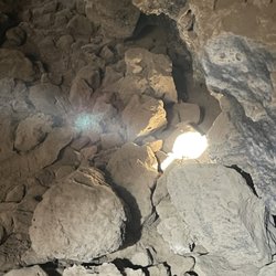
Mojave Lava Tubes - View of the tube from on top

Mojave Lava Tubes

4.7(23 reviews)
12.3 mi

I can't believe I forgot to review this crazy adventure from a couple years ago…read more I have visited the lava tubes in Hawaii and when I found out we had one in the middle of the desert I knew I would have to come check it out. Post pandemic, my husband and I set out on a Saturday morning to find and explore these tubes. From Las Vegas it takes roughly 2.5 hours to get there. Driving the I15 freeway, take the Kelso Road exit and make a left turn. Drive on this road till you see Aiken Mine Road. Turn here and it will take you to the tubes. Be advised this is a dirt road not maintained so it can be a challenge for a regular vehicle. High clearance vehicles are preferred. Once you arrive and park, you will see the trail that takes you to a ladder that you will climb down to enter the tube. Be careful and watch your head as you descend into the lava tube. It is very easy to hit your head on the overhead rock hanging down. If you hit the tube at just the right time, light will filter through and it's very interesting and unique. Be careful with the dust down there, it is swirling all around from foot traffic. I advise wearing a mask like I did in order to not breathe in bad air. Although not as picturesque as the Hawaiian tubes, it was a fun little adventure to seek out. Remember to follow the principles and Leave No Trace.
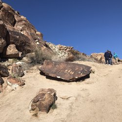
Very cool spot, off the beaten path... and when I say beaten, I mean it -- think bumpy, rocky…read more.. all the things besides smooth lol! This is about a 30 min drive off 15 and then once you turn off the main road, you'll take the unpaved road about 4.5 miles to the lava tubes where you'll then walk about .3 miles or so! Super easy and straightforward to find, worth it but take a look at my tips to understand what to prepare for to make it a great experience! 1. Make sure you have a vehicle that is higher up and can with stand a bumpy road -- it is no joke! 2. Climb all the way down into the lava tube, don't just look from above, otherwise it's not worth the trip. 3. Make sure you have some kind of light source because it's dark and you will bump your head or trip if you can't see. If you only have your phone, highly recommend videoing with the flash on, it is MUCH brighter than just the flashlight. 4. There is minimal to no service so just be prepared for that. 5. The 4.5 mile road to the lava tubes is one wide enough for cars going both ways most of the time, but there are times it's really a one lane road, so be aware of who is coming at you from afar and use the pull offs if needed. 6. Optimal lighting in the tube is between 10-2. Think peak sun time. This is slightly dependent on the season as it could fluctuate a bit, but ultimately that's the best time! Hopefully my review and tips help you have a great adventure at the lava tubes! Enjoy!

Photos
Mojave Lava Tubes - Ladder that takes you to the tube

Ladder that takes you to the tube

Mojave Lava Tubes - Entrance to the tube, watch your head as you climb in.

Entrance to the tube, watch your head as you climb in.

Mojave Lava Tubes - More light filtering in

See all

More light filtering in

Hole-in-the-Wall Rings Trail - So many unique rock windows in the desert

Hole-in-the-Wall Rings Trail

4.7(7 reviews)
21.1 mi

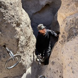
I love being impulsive and waking up to go adventuring. My man and I woke up on a Friday morning…read moreand decided we were going out to the Mojave Desert to see the lave tube and hike this very short but interesting trail. We did this trail a couple years ago and I just had failed to review so here we go. It's easy to find and the trail is approximately 1.4 miles with an elevation gain of 131 feet. The trail is a complete loop. What makes this trail fun and unusual is at the end in order to leave the narrrow canyon, you must use rings that are bolted into the wall to climb out. You can also descend the canyon with the rings but climbing up and out was much more challenging and rewarding. It helps to be in good shape as you will need to be strong enough to pull your body up through the canyon via the rings. The canyon you hike into is so incredible and so many different rock formations. I loved all the rocks with holes as you could hear the wind blowing through them. Plus there are so many petroglyphs along the way. Lots of photo opportunities and I highly recommend exploring this trail when you are looking to hike a one of kind trail. Plenty of parking and be sure to where solid trail shoes or hiking boots. Remember to pack in and out and LEAVE NO TRACE.

Absolutely gorgeous trail. It passes by wind-worn caves and a petroglyph, and ends at a set of…read moresteel rings for you to climb up (or down, depending on how you traverse the loop). I've never hiked such a unique trail before! The visitor center is also near by and has a gift shop, water, flush toilets, and a nice ranger stationed there who can provide more information about the area and advice. The center is very small so there aren't as many displays to educate you about the surrounding area compared to other visitor centers, but that's ok as you'll probably be itching to go outside and take in the views.

Photos
Hole-in-the-Wall Rings Trail - Coming around the bend and into the canyon where all the fun is.

Coming around the bend and into the canyon where all the fun is.

Hole-in-the-Wall Rings Trail - Hubby coming up through the rings

Hubby coming up through the rings

Hole-in-the-Wall Rings Trail - The visitor center near the trailhead

See all

The visitor center near the trailhead

Mitchell Caverns Natural Preserve

Mitchell Caverns Natural Preserve

4.4(27 reviews)
25.8 mi

I've been on a LOT of tours in a LOT of places around the world, and Willy is in my top 10! The…read morecaverns are pretty cool, but Willy's knowledge, humor, pacing, and care made this a five-star experience. Our group ranged in age from tween to 60s and everyone was engaged for two hours. I'm a California Naturalist with high standards and Willy knows his stuff! As a native Californian I especially loved knowing he's local, young, and a former CCC "graduate". His contributions and energy are why these government programs are so important. Must see if you're visiting the area, but be warned -- you need reservations and these fill up weeks ahead of time. The paved road, nature center, views, and well-organized everything made this a real treat!

Tours are offered on Friday-Sunday and Holiday Mondays at 11am and 2pm from October to May. In June…read moreand September, tours are on the same days but only at 10am. Reservations are highly recommended, as tour size is limited to approximately 12 people; and reservations are only taken via phone on Mondays between 8am-5pm. Cost is $10 per adult 17+ and parking is $10, payable at the visitors center upon arrival for the tour. The tour itself takes approximately 2 hours, and is about 1.5 mile round trip. It may feel strenuous for some people walking back up to the parking area from the caverns. Our guide was very knowledgeable and informative. I recommend bringing food and drinks to eat before or after the tour, as none is available. Also, leave your bags/belongings in the car. You will be asked to put these items at the entrance of the caverns, including water bottles.

Photos
Mitchell Caverns Natural Preserve

See all

Amargosa River Canyon

Amargosa River Canyon

5.0(4 reviews)
49.1 mi

Enjoyed going thru this river and canyon on a side by side! We camp at Dumont Dunes and this is…read morelocated in that vicinity. This river is an underground river but when it rains hard there's so much water on the trails it looks so cool! Such a great experience seeing this canyon! Totally recommend!

I have been hiking in the area for over a decade and it's always been a very special…read moreplace--history, great geology, and a date shake--all are part of hiking here. The Amargosa Rover Canyon offers several trails in China Ranch and beyond. There are two ways to hike the canyon itself. The best way to enjoy most of the entire canyon is to spot cars. Leave one at China Ranch and drive the other to Tecopa, California and park where there's public parking behind the post office. From here, hike south following the trail. Mostly you'll hike on the railroad bed of the T&T Railroad (Tonopah and Tidewater) bed as it follows the Amargosa River through the canyon. At places, the trail leaves thew railroad bed and makes wide arcs on the east side of the trail. After 5 miles, you'll reach the turnoff for China Ranch and where the spur from the T&T was built to bring gypsum from the mines above the ranch from the Morrison Siding. Along the way through the canyon from Tecopa, you'll see areas with barbed wire. This is where horses and cattle were fenced in to keep them off the railroad tracks. You will see no track. The railroad stopped operating in 1940 and the rails were pulled up and used for World War II needs. About a mile and a half from the Ranch, there's a turnoff to the west (right) and this leads to a little waterfall on the river. Beyond this about 1/4 mile, there's another turnoff--again to the west--that leads to a slot canyon that is blocked by a huge chockstone. Both side trails have signs but they have faded a lot over the years. When you almost reach the 90º bend in the river, the trail goes up a hill and heads east (left) toward the ranch. Before going up the hill, take time to look at the wood left from when this was where the gypsum was loaded onto ore cars over 100 years ago. Follow the trail from here to China Ranch. On this last bit, you'll come to a building. My first photo of this building is from 2005. The building was called the Tuff Building and the sign that was there said it was first a bar and then an assay house. The building was supposed to have been repaired that years. 1w2 years later, another portion has fallen over including the concrete piece from the doorway with the 1903 construction date in the concrete. I'm sure when I hike here next year, the rest of the southerly wall will be down too! What a shame! There are several hikes. After this 6.5 mile hike, you'll want to have a date shake and perhaps some date cookies. You earned them. On another day(s), you can explore the other trails in China Ranch. After your shake, take the car you left at the ranch and ride back to Tecopa to get the one where you started your hike. This is the way to see almost the entire canyon.
Photos
Amargosa River Canyon

See all

Teutonia Peak - hiking - Updated July 2026

Loading...
Loading...
Loading...